

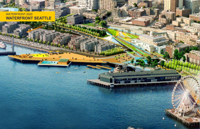
Specific. Delightful. Peculiar. That is the future of the waterfront, according to lead project designer James Corner. Updated waterfront redevelopment plans were unveiled last Wednesday to a packed house at Fischer Pavilion. The format for the evening was a mix of open house, presentation, and Q&A.
During the presentation, the public was introduced to a new and important figure of the waterfront project, Jared Smith. Mayor Murray tapped Smith three weeks ago to head the newly formed Office of the Waterfront. Smith isn’t new to the waterfront project; he was previously involved in planning the new SR 99 tunnel design. He will now play a significant role in the effort to bring the Alaskan Way Viaduct down, complete the seawall, and roll out the revitalised waterfront.
But the main subject of the evening was James Corner’s whimsical, colourful, and people-focused Waterfront 2020 presentation. Corner laid out his rationale for his expansive, water-oriented designs. He noted that Elliott Bay plays into the psyche of Seattle. Spatially, the city’s downtown streets are laid out in an east-west orientation. And naturally, those same streets terminate at the water’s edge to create strong view corridors. But more than that, the water is a primary driver of Seattle’s economy, recreation, culture, and transportation. When you think of Seattle’s neighbourhoods, they’re almost always associated with water somehow. Water is indeed the psyche of Seattle—it’s inseparable—with Elliott Bay its central focus.
Project goals
Corner explained that the waterfront must be organised in three ways:
- The City Scale. The design should recenter the city around Elliott Bay. It should be a place that draws people to the waterfront to claim as their own.
- The City Center Scale. Connecting the city centre to the waterfront is key. The viaduct and the hills have acted as barriers. With the viaduct gone, these connections can be made visually and physically.
- The Waterfront Scale. Designs should enhance the waterfront so as to recognise its many unique spaces and functions. Some of these functions being strolling, sitting, viewing, concerts, exercise, transportation, and more.
Corner envisions a waterfront that is well programmed. Most public spaces, large or small, require some level of active programming if they are to be actively used throughout the year. The waterfront is no different. Programming can come in many different forms, such as art exhibits, farmers’ markets, concerts, pools and playful activities, and street vendors. To accommodate these, Corner has intentionally designed spaces so that they are multidimensional, flexible, and easy to repurpose as needed. Friends of Waterfront Seattle, a group consisting of many waterfront businesses and others, will be a major institution ensuring that the waterfront is diversely programmed year-round.
Access to the waterfront will be greatly improved by taking advantage of a viaduct-free Alaskan Way. New pedestrian bridges, elevators, staircases, and wider sidewalks will be added along the project’s length. Intersections can be modified to give priority to pedestrians. Transit connections will be well integrated between buses and ferries to make transfers and movement easy. And, a significant amount of the street will be dedicated to cyclists with the addition of cycletracks.
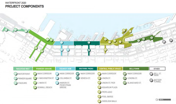
What is the waterfront?
Broken into six zones, the project area is 26 blocks long (~1.5 miles) reaching from CenturyLink Field to Bell Street. Each of the six zones has a unique character and history. Corner’s design is intended to complement those histories by intensely focusing on them as individual districts.
Railroad Way
Forming the most southern section of the waterfront, Railroad Way is intended be the terminus of the waterfront. This portion of the project will be entirely pedestrian-oriented in its design. Once the viaduct has been removed, the vacated Railroad Way will be reused as a wide, tree-lined avenue. To honour its history, the design may playfully incorporate steel tracks into the street to draw its alignment from the stadiums to Pioneer Square.
Pioneer Square
 The Pioneer Square section offers a number of opportunities, despite its trafficked nature leading up to the ferry docks. Because the right-of-way is so wide, much of it will be converted to non-vehicular uses. On the east side of the new Alaskan Way, a 30′ wide sidewalk will be put in place. This will link the stadiums of Railroad Way to Pioneer Square and the central waterfront. By creating a wide sidewalk in place of the former viaduct, buildings will reorient toward the street and water. It’s easy to imagine cafés and businesses springing out into this space for biergartens, event space, or sidewalk cafés. The section also has three prominent features: a new habitat beach, view corridors terminating prominently on the Washington Street Boat Landing, and the beginning of the central waterfront promenade.
Transit Hub
As the name suggests, this section is the transportation heart of the waterfront. The Colman Dock, West Seattle-Downtown bus stops, promenade cycletrack, and passenger ferries all converge to create a very busy transit-oriented space. Corner has two interesting ideas for the area. One is to replace the Marion Street pedestrian bridge, a bridge connecting the Colman Dock ferries and First Avenue. The new bridge would be much brighter and playful than the current one. The second idea is a large bikeshare shed for waterfront users (if and when Seattle rolls out the Puget Sound Bikeshare).
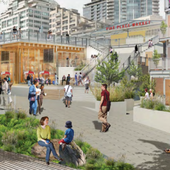
Historic Piers
 Piers 54 through 57 make up this section of the waterfront. To encourage activity, a grand promenade will be placed along the historic piers stretching 100′ in width with kiosks, seating, viewing spaces, and well placed landscaping to centre the spaces. Like Pioneer Square, frontages of buildings on the east side of Alaskan Way will hopefully reorient toward the water.
Piers in this area present an interesting opportunity to focus view corridors diagonally. Spaces terminating between piers will be visually linked east-west with the streets and diagonally with the piers. Materials on the ground, kiosks, seating, and other physical elements within these spaces will help make these visual cues clear to pedestrians.
The biggest access element added to this area will be the Seneca Street Deck, which will offer wonderful views to the water—much like the viaduct. At the same time, a staircase and elevator will give pedestrians vertical access between First Avenue and the waterfront.
Central Public Space
This may be the most significant space on the waterfront; it’s the closest section to the heart of the city centre. When you think of this space, you probably think of its most identifiable attractions: Pike Place Market and the Seattle Aquarium. These institutions are paramount to the central waterfront and the city centre. But these aren’t the only amenities abound. Waterfront Park, Pier 62/63, and the other piers make this an ideal area for play and culture.
 To connect these attractions, Overlook Walk, a gentle sloping landmass over Alaskan Way, will be constructed as a multipurpose space. Three new buildings will be strategically built within it. Nestled into Overlook Walk, these buildings will be visible, but not intrusive to the vistas or historic elements of the area. They also will provide a variety of uses such as social and affordable housing, public events space, restaurant and café space, and an artisan extension of the Pike Place Market.
Union Terrace is another significant connecting point from the city centre to the waterfront. View platforms will extend out from First Avenue and Western Avenue respectively. These will offer excellent vistas, much in the same way that the viaduct is known for. The platforms form a practical function as well by allowing elevators to provide step-free access to and from the waterfront.
Waterfront Park and Pier 62/63 both will be expanded and redesigned spaces. Offering year-round programming, visitors can expect activities and temporary features such as a sandy beach, Christmas village and tree, cultural events, or waterfront concerts. Waterfront Park may receive a water feature as its key attraction. The water feature would be a flexible space so that it could be changed as need. Turn off the water and drain the area, the space transforms into a popup farmers’ market or concert space. Turn back on the water and run through the water sprays, mist, and shallow pooling water. Pier 62/63 is a strong point on the waterfront reaching far out into the water. Corner suggests that it should become an active space similar to Waterfront Park, perhaps even with a pool and spa barge!
Belltown
Belltown forms the last portion of the waterfront project with Bell Street as its terminus. This area has many barriers, which makes any design challenging. For instance, Elliott Way will ascend a steep incline from the waterfront and must cross the railway tracks. At the same time, Elliott Way is flanked with very steep slopes to the east and west. Parking garages along the street certainly do not help to create an attractive space. Despite this, Corner has planned wide sidewalks, a tamed street, and some pedestrian amenities. Belltown will receive a new park and overlook. Together, these will be wonderful additions to the Bell Street Park woonerf. Meanwhile, Lenora Street will receive new access by way of a pedestrian bridge over the tracks, connecting Belltown to the waterfront.
Take away
Corner’s design for the waterfront is a very ambitious and practical one. His approach is comprehensive by recognising not only the future needs of Seattle, but taking note of its past. His vision of the waterfront is one that enhances the economic, recreational, cultural, and transportation value that the waterfront plays in the life of Seattle.
For 61 years, the waterfront has been severed from the city by a highway. In a few short years, that highway will be gone. We have the opportunity to reclaim that space as truly our own. We deserve a renewed and treasured waterfront to complement the city’s vibrant urban fabric, and Corner gives us one set of possibilities to accomplish that.
For a copy of the full presentation on Waterfront 2020, be sure to check out the online PDF.

Stephen is a professional urban planner in Puget Sound with a passion for sustainable, livable, and diverse cities. He is especially interested in how policies, regulations, and programs can promote positive outcomes for communities. With stints in great cities like Bellingham and Cork, Stephen currently lives in Seattle. He primarily covers land use and transportation issues and has been with The Urbanist since 2014.