

An important milestone in the Lid I-5 technical feasibility study has been reached. Data collected by engineering firm WSP indicates that it is structurally possible construct a freeway lid over Interstate 5 (I-5) in Downtown Seattle within all four of the sub-areas studied, which extend from Madison Street to Denny Way. The study also found that integrating midrise and highrise buildings with the lid structure would be compatible and in some cases preferable from an engineering standpoint to deal with grade changes. This is good news for people who want to maximize housing on the freeway lid.
The proposed project area for the I-5 freeway lid runs straight through one of the most challenging stretches of the Seattle interstate corridor. From topographical changes to a high density of off- and on-ramps, each of the sub-areas presented variables for WSP’s structural assessment of a future freeway lid to contend with. Their analysis yields insight into not only the challenges and opportunities presented within each of the four sub-areas of the proposed Downtown freeway lid, but also future areas of I-5 that could be lidded, such as NE 45th St in the University District.

Before moving forward, it’s important to note that ownership of both I-5 right-of-way and air space belongs to the Washington State Department of Transportation (WSDOT), who is working with the WSP consultant team, City of Seattle, and Lid I-5 campaign to “understand the requirements and constraints that would affect freeway lid feasibility in this study area.”
WSDOT has recognized the need to identify long-term plans for this segment of freeway, which needs updates to increase seismic resiliency and better serve today’s transportation needs. A crucial first step is securing funding for the I-5 Systems Partnership, which was not funded by the state legislation in last year’s budget session. The agency will be returning to legislators with another ask for I-5 planning funds in the next budget cycle.

When completing its research into the site conditions of the four freeway lid subareas, WSP used some technical assumptions including:
- Projects constructed by April 2019 are included in the feasibility assessment; projects currently in planning are not considered to be built.
- Existing bridges, ramps, walls, or other structures (excluding buildings and tunnels within the study area boundary can be removed, modified, or replaced for the purpose of this analysis.
- The study will only assess structural modifications to the existing lids at Freeway Park and the Convention Center necessary for potential edge integration with a future lid.
- The existing capacity of I‐5 will not be reduced; permanent I‐5 lane configuration modifications may be considered; temporary I‐5 impacts may be permissible.
At a technical feasibility study stakeholder meeting, Alex Hudson, executive director of Transportation Choices Coalition, questioned why the study did not take reductions in I-5 capacity into consideration as part of its research. Greg Banks, who was representing the WSP consultant team, acknowledged that while there may be reason for WSDOT to reduce I-5 capacity in the future, such a scenario was outside of the scope of the current technical feasibility study.
Sub-Area 1: Integrating with historic Freeway Park

The map and photographs above display some of the challenges presented in Sub-Area 1, which includes infrastructure for Freeway Park, which has been nominated for the National Register of Historic Places. (Credit: WSP )
WSP presented three possible concepts for lidding this sub-area. The first concept, which would lid the James Street freeway exit, southbound I‐5, and northbound I‐5, presents benefits both in the form of a maximized lid size and simplified intersections with road safety benefits.
However, this concept would also require the demolition of existing I-5 ramps and modification of existing walls. The Freeway Park box gardens would also need to be removed in order for this concept to work, presenting a hurdle for future lid design plans since Freeway Park is eligible and has been nominated for the National Register of Historic Places.
Two other concepts that would lessen the impact on the existing Freeway Park and/or ramps were also shared; however, both would result in a smaller and discontinuous lid structure.
Sub-Area 2: Increasing active park uses near the Convention Center

Extending from Seneca Street to the the Convention Center, the lid concept for the second sub-area would lid University St, southbound and north I‐5, and Hubbell Place. While such a plan would require demolition of the Freeway Park edges, modification of existing walls, temporary I‐5 traffic impacts, and partial demolition/replacement of the overhangs, the benefits of the lid would include noise reduction, increased connections, and an increase in area for active uses within Freeway Park.
Sub-Area 3: Expanding on the Pike-Pine Rennaissance

In some ways this sub-area is the easiest location throughout the entire proposed freeway lid project site to imagine a future in which I-5 vanishes from the landscape. However, while the area doesn’t have some of the easily visible challenges addressed in the other sub-areas, WSP’s concept for a complete lid over Sub-Area 3 does require permanent I-5 lane reconfiguration in addition to demolition and replacement of overhangs and modification of the existing walls.
A second concept that included partial lidding was also studied. This concept maintains the existing ramps as they are, but it would also result in a smaller lid area. Since this stretch would connect important future improvements such as the Pike-Pine Renaissance and Melrose Promenade, and also touches on existing civic/cultural institutions such as Convention Center and Paramount Theater, the case for a lid that could seamlessly integrate into the surrounding built environment is strong here, despite potential challenges.
Sub-Area 4: Challenging topography

The final sub-area studied faces many of the same challenges as the previous ones in terms of the demands it would place on I-5. Removal of existing ramps, modification of walls, and lane reconfiguration would also be necessary here. A partial lid would reduce impacts, but would also result in less new land created and fewer improvements for the surrounding environment.
While the entire proposed freeway lid project area is topographically challenging, Sub-Area 4 is one of the places where it is easiest to observe a steep change in grade between the east and west sides of I-5. Given the construction materials available, the grade presents a challenge in how the edge of the lid would connect to the surrounding landscape.
WSP explored two scenarios for integration of the freeway lid into the steep topography. The first would use raise the profile of the lid approximately four feet and require an allowance of five feet of landscaping on top of the structure.

However, in areas such as Sub-Area 4 near Denny Way where the grade is steeper, WSP discovered that a better solution would be including buildings on terra firma (solid ground) that connect directly to the lid structure. Access to the future lid could come through the building on a second or third floor, depending on the final design. Such a design could maximize new residential or commercial development on the edges of the freeway lid, while preserving opportunities for green space in other areas of the freeway lid.

What can be built on the I-5 Lid?
The concept of integrating buildings into the edges of the lid raises the question of exactly what kind of structures can be built on the proposed freeway lid. While WSP considers this question to be the next phase of its engineering study, it has already compiled preliminary data what possible weight bearing loads different segments of the freeway lid could carry.
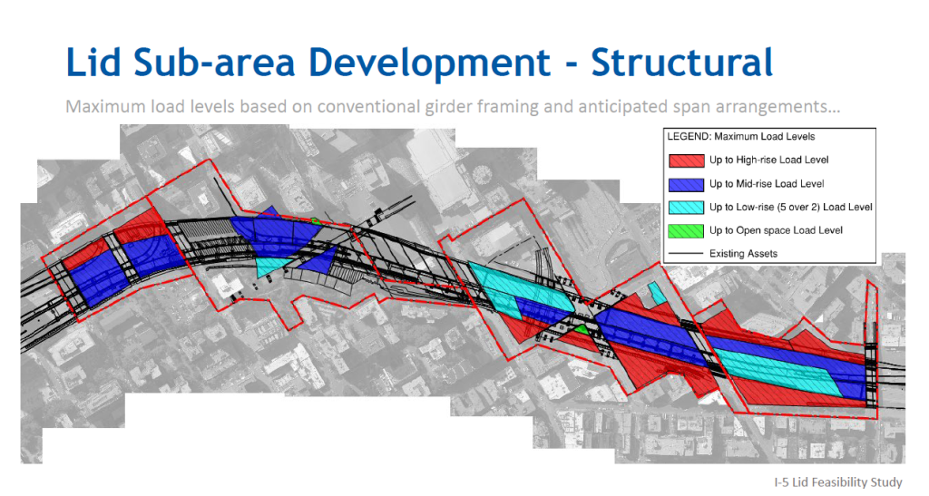
As the map above illustrates, the preliminary data suggests that the lid’s edges would be most appropriate for highrise development, while much of the remainder of the lid could carry either midrise or lowrise development.
WSP will be sharing more detailed information about future development scenarios on the proposed freeway lid with the public in November at the next technical feasibility stakeholder meeting.
Natalie Bicknell is a member of the Lid I-5 Campaign Steering Committee.
It’s our fall subscriber drive. Please consider a monthly donation if you enjoy articles like this one.
2019 Fall Subscriber Drive

Natalie Bicknell Argerious (she/her) is a reporter and podcast host at The Urbanist. She previously served as managing editor. A passionate urban explorer since childhood, she loves learning how to make cities more inclusive, vibrant, and environmentally resilient. You can often find her wandering around Seattle's Central District and Capitol Hill with her dogs and cat. Email her at natalie [at] theurbanist [dot] org.