

Using a pack of highlighters to show the absurdity of developing a private enclave in the city.
Last Tuesday, the Seattle Department of Construction and Inspections (SDCI) held an online public information session to discuss the permitting process for redeveloping the Talaris campus. The proposal is to locate 65 new single-family detached homes onto the 18-acre former research institute. Neighbors in Laurelhurst have expressed opposition to changing the historic site and losing trees. Civic organizations like Affordable Talaris have expressed shock that the city would approve a cloistered enclave of McMansions at a time of climate, housing, and public health emergency.
Between the very big ideas of community and the very small plans to build a house, there is a thin layer of paperwork that establishes the shape of places we live. We’ve talked a little about it before, drawing property lines through subdivision. Right now, in real time, we see that process at Talaris. It is ruining an invaluable resource. By virtue of its single family zoning, the development is exempt from the Mandatory Housing Affordability (MHA) program that would have required affordable housing contributions.
Understandably, “process” can be hard to see because it is difficult to connect those plansets with the real world. What does this mess of lines and tables actually translate to in real life? Today we’re going to talk about reading those documents, how you can do it, and why it’s very important you give it a try. Bonus: there will be coloring.
Highlighters Out
To start, let’s get a set of plans. Seattle makes this fairly easy. Start at the Seattle Services Portal. If you received notification as a neighbor or heard about the project through a community organization, you probably have a project number. Search using it. The Talaris project is 3030811-LU. If you don’t have a number, try the address or the name of the project. And if you don’t add the “-LU” extension, the search will turn up a lot of garbage.
Look for the most recent application that has a “review in process.” Depending on your search, this may be higher or lower on the list. When you find it, click and you’ll be directed to a page about the particular project. You want to click on “Attachments” because that’s where all the uploaded documents live. For Talaris, the plan set is on page 10 because there’s been a lot of correspondence. The full plan has text and extra images that we’ll use later, but here’s a picture of the overall version we’re going to work with:
Now that we have a current set of plans, let’s get into reading them. That starts with coloring. You can stick with a few basic colors. Leave the art markers for destress coloring. The point is to go around each type of line on the plan with a separate color. Here’s the breakdown in colors and the order that I layer them over the plan:
- Orange – Property lines
- Yellow – House lots
- Blue – Roads
- Green – Environmental
- Red – Easements
- I also keep a red pen on hand to liberally circle and label things “WTF?”.
For this article, I colored things digitally because I needed the illustrations for this article and I wanted to sit on the couch and watch Umbrella Academy (which had a much better second season than first). If you do this on a computer, anything more than a PDF markup app will be overkill. You don’t need a universe of colors and vector tools. My suggested colors come from a pack of highlighters that I used to mark up paper copies for years (darker colors and shades involved going over something a second time). The important thing is the process.
Northwest Nonsense – Ask Questions
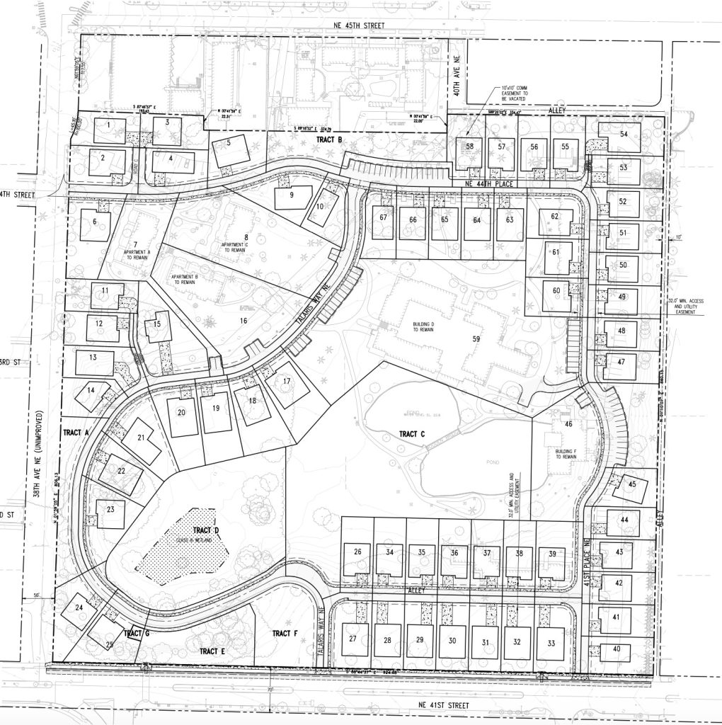
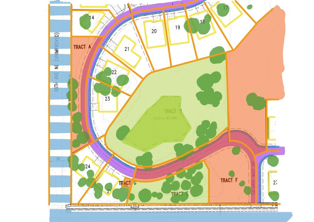
Using color, we can build up an understanding of what’s happening on the site. Let’s start in the northwest corner at the top left. It’s the main entrance from Sand Point Way via 38th Avenue NE. The boldest black lines labeled with directions are property lines. Let’s start there and build up colors. Orange for property lines. Yellow for house sites. Blue for roads. Like so:
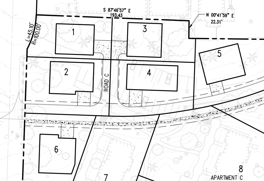
Start: The proposed layout of the northwest corner of Talaris, uncolored. 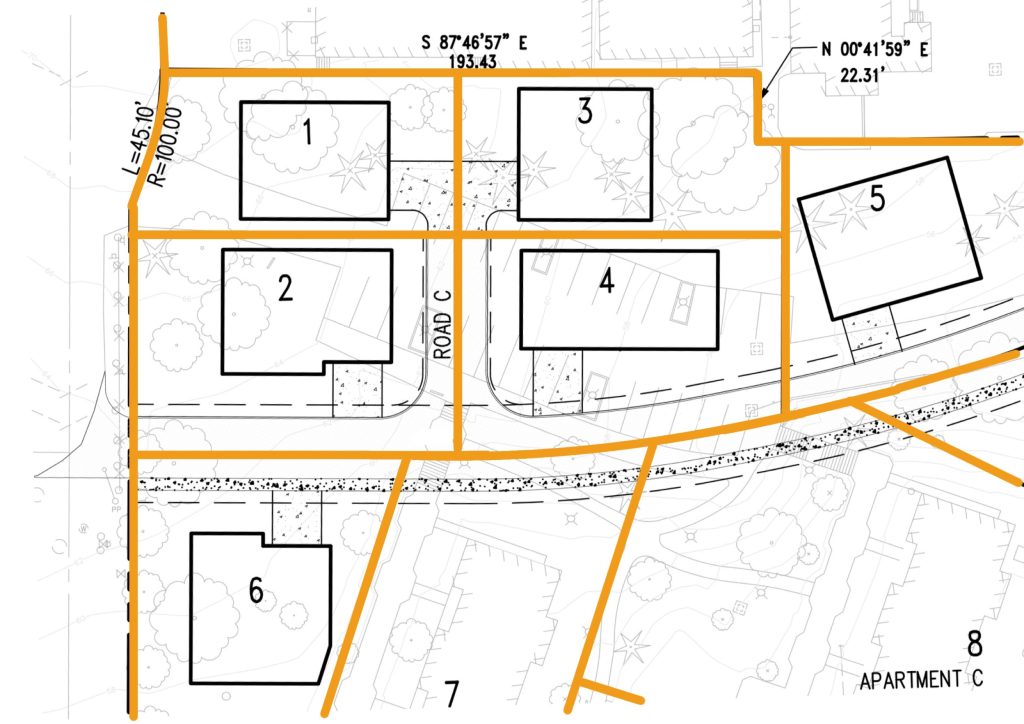
Layer 1: Adding in orange property lines, which tend to be the boldest lines on the drawing. 
Layer 2: Solid rectangles showing proposed house footprints get highlighted in yellow. Buildings to remain can be shaded in. 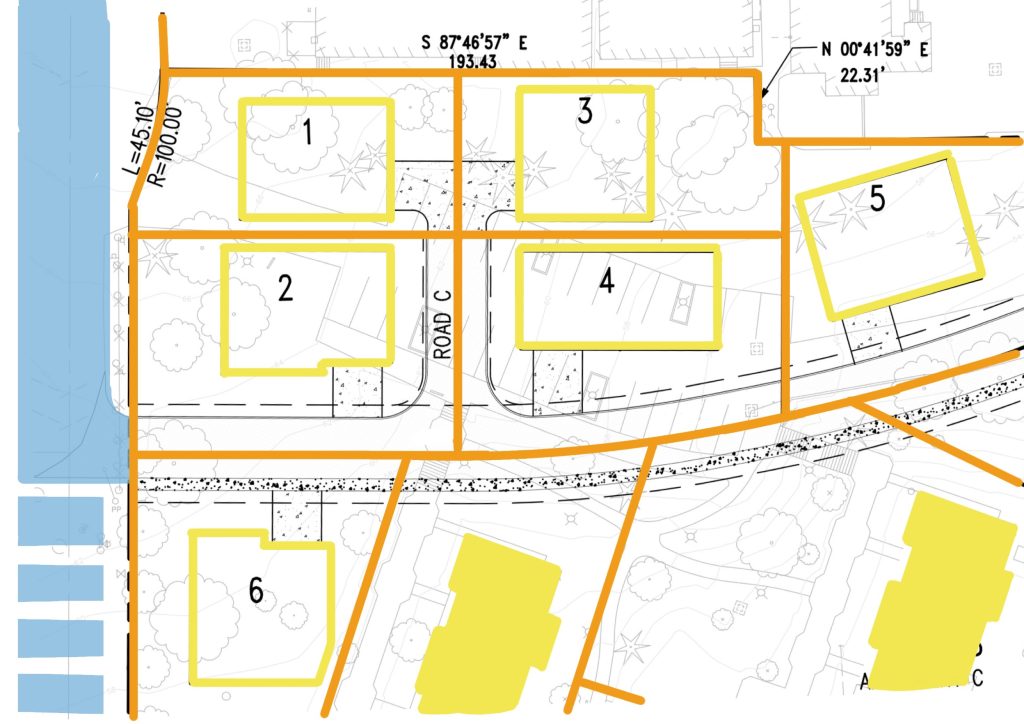
Layer 3: Blue designates the right-of-way for the existing street connecting to the development. 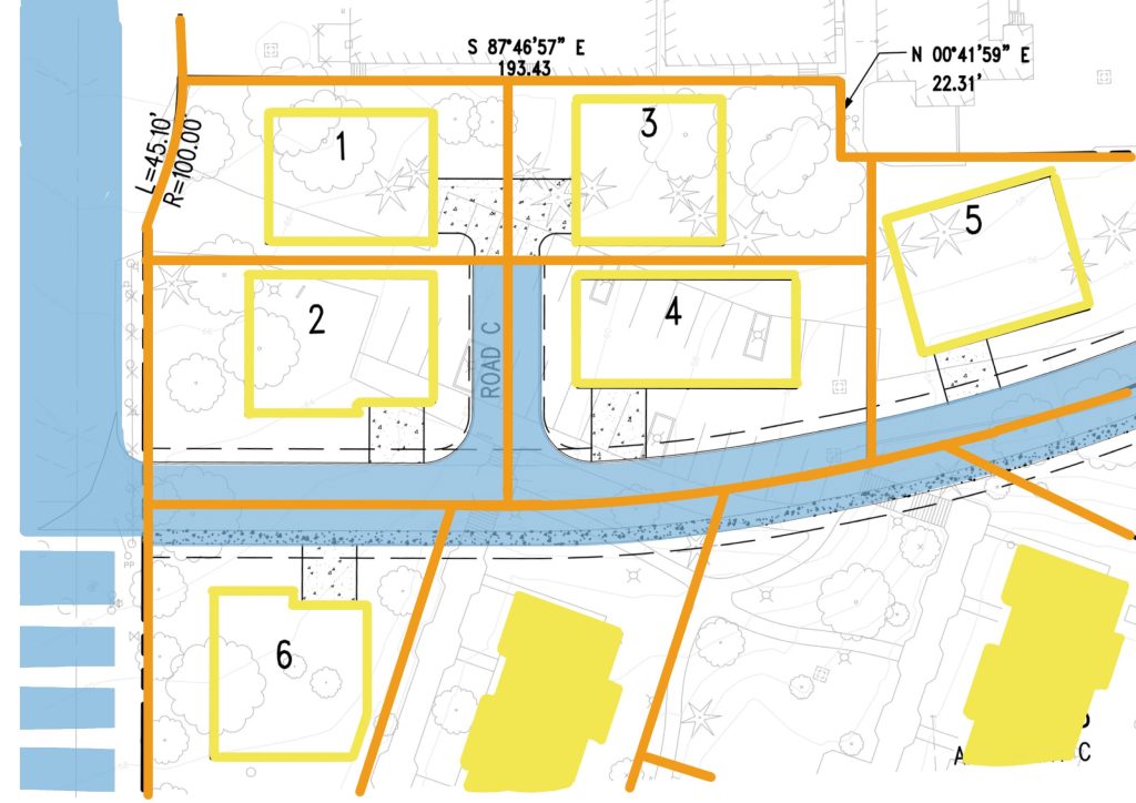
Layer 3.5: Blue is carried inside to show the proposed streets in the subdivision.
And now we have to sit here and look at this a second because that’s odd. Why doesn’t the big existing street outside the property have any property lines running through it, but the new proposed streets do? This is a point where we have to seek clarification by reading the text.
What we find is that there are not going to be public roads in the new subdivision. All of the roads are going to be private easements. Every road cuts 16 feet off one or more sides of the new properties. One side of the private street is going to be a separate sidewalk easement.
So if the City doesn’t take dedication of the roads, who is going to maintain them? Again, we look for clarification in the narrative and find that they will be maintained by a Homeowners Association (HOA) in conformance with City standards. That puts the burden of maintaining over 3,000 feet of 32-foot wide pavement, with sidewalk, on 65 homeowners and whoever takes ownership of the convention properties. And we have seen private streets with a single sidewalk maintained by an HOA elsewhere in the region and can question whether they are appropriate for anywhere in the city.
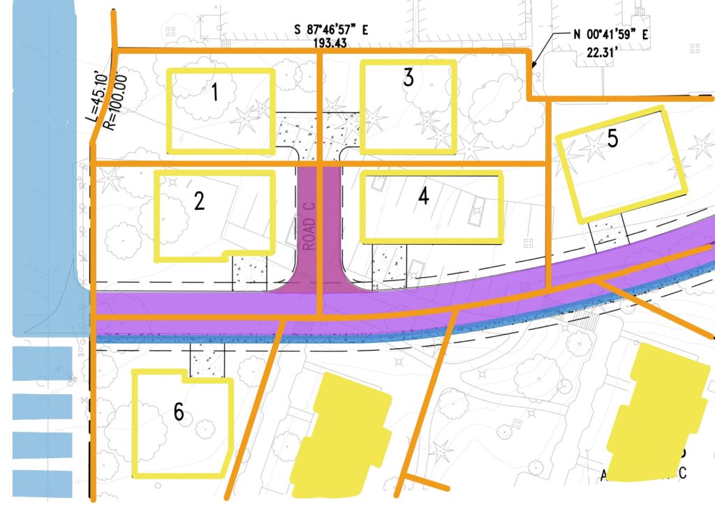
Why does that Road C also look a little strange? It’s narrower and doesn’t have any sidewalk. If it’s a road, then why aren’t the driveways for Lot 2 and Lot 4 coming off it? Well, again turning to the text, we find out that it’s not even a private street. It’s a shared driveway easement just for Lot 1 and Lot 3. That means Lot 2 and Lot 4 have their lots shaved down by 16 feet on one side and 11 feet on the other.
It also means that running through this little portion of the site are three separate types of easements, so we can shade them a little different. It really emphasizes how large the proposed houses are on these lots and how close together they’re putting a bunch of driveways. Some of those lot lines are skewing off at weird angles. Let’s keep that in mind. In the end, the northwest corner of the site looks like this:
Just by asking a few questions, we’ve found out some interesting things. There’s no public roads here. They’re shaving down properties with easements but making the houses larger. And they’re putting all these responsibilities on an HOA. Not totally satisfying answers, but this is just the start for this site. Let’s continue.
The Crying of Lot 59 – Look for Absurdity
The methodical nature of coloring a plan starts to give a sense of what is normal and what is irregular. As we work through this set, we notice where a lot of straight lines turn into a lot of curved lines. Just like in the northwest, we can move to the northeast and central parts of the map. The northeast corner has a right turn for NE 44th place with rectangular lots on both sides. Trace the property lines in orange. Trace the proposed houses in yellow and LORDY WHAT IS THAT THING?
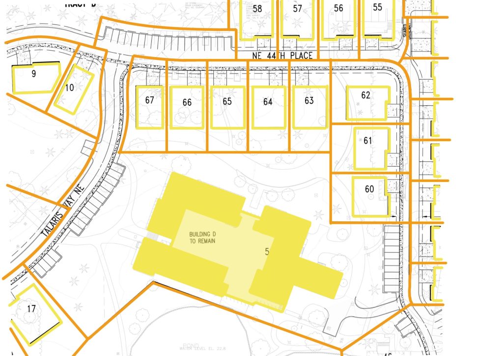
The big yellow blob at the middle of the site is the historic convention center complex that is proposed to remain. But what in the world is going on around it? Let’s highlight the lot it sits on and see if we can learn more.
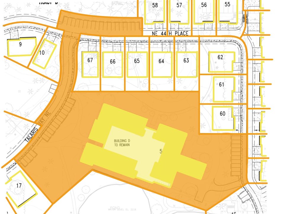
Lot 59 is proposed to stretch between the two private roads on the site, then go up and connect to the third. The bulk of the lot cuts in and out to wrap around neighboring private lots. Then it stretches 140 feet north to a secondary parking lot. The long stem takes up the whole width of Talaris way before connecting to the parking lot that scoops chunks out of Tract B and Lot 58.
A couple weeks ago, The Urbanist ran a contest about the region’s most bizarre lots. The winner can deservedly retain their title, but this new Lot 59 is absurd and would give them a solid run. Some of those strange lots in the contest were remnant edges where two properties didn’t match or where there was unusable land around a natural feature. What’s unique here is that Lot 59 is supposed to be a usable parcel. The extended stem is created intentionally to provide adequate parking. It looks like a poorly designed tractor.
This kind of leviathan causes problems by changing the shape of other lots like those scoop-outs. It explains why some of those lots in the northwest are shearing off at weird angles. The long stem also creates an erratic series of ownerships along Talaris Way. Some of the roads are owned by the neighboring property. Some of them are this remote lot. Some meet in the middle. Here it takes up the whole width. It’s the kind of goofy ownership that sets up the community for conflict between this property owner, the HOA and future neighbors. Looking for absurdity shows us these future points of conflict.
Paper Cuts – Stop Permanent Scars
As we’ve colored, we’ve been able to ask questions and look for absurdity. Understanding a proposed preliminary plan allows us see the places where our land will be divided. Talaris is going through this process so that they can create and sell off taxable lots that will exist permanently in the land records. Such a process is not to be undertaken lightly.
In the southwest corner of the site are HOA parcels and a few lots. Let’s work through highlighting them and see what we can find. Orange property lines, yellow building areas, shades of blue for the public streets and private street easements.
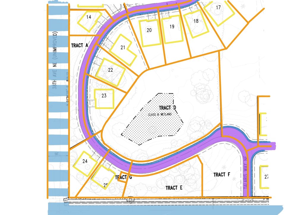
Let’s stop here for a second. The blue public street to the west of the parcel looks a different because it is unimproved. It is a paper street (not the soap company) existing only in the deed record and not on the ground. The land is wide enough to legally provide a street, is still owned by the city as a right-of-way, but one has never been built. This is the epitome of permanence in the land record.
What it effectively does is strangle Tract A. To avoid the paper street, the applicants have slalomed the proposed private street between a couple more lots and the edges of the property line. The proposed Talaris Way comes within its own width of the edge of property, leaving a tiny crop of trees on Tract A that have little more environmental use than the dead basil on my windowsill.
On the other other side of Talaris Way, there’s houses that separate the road from a “Class III Wetland.” That’s a lot of road and houses right near a slough. Let’s pull out the green and highlight some trees and natural resources.
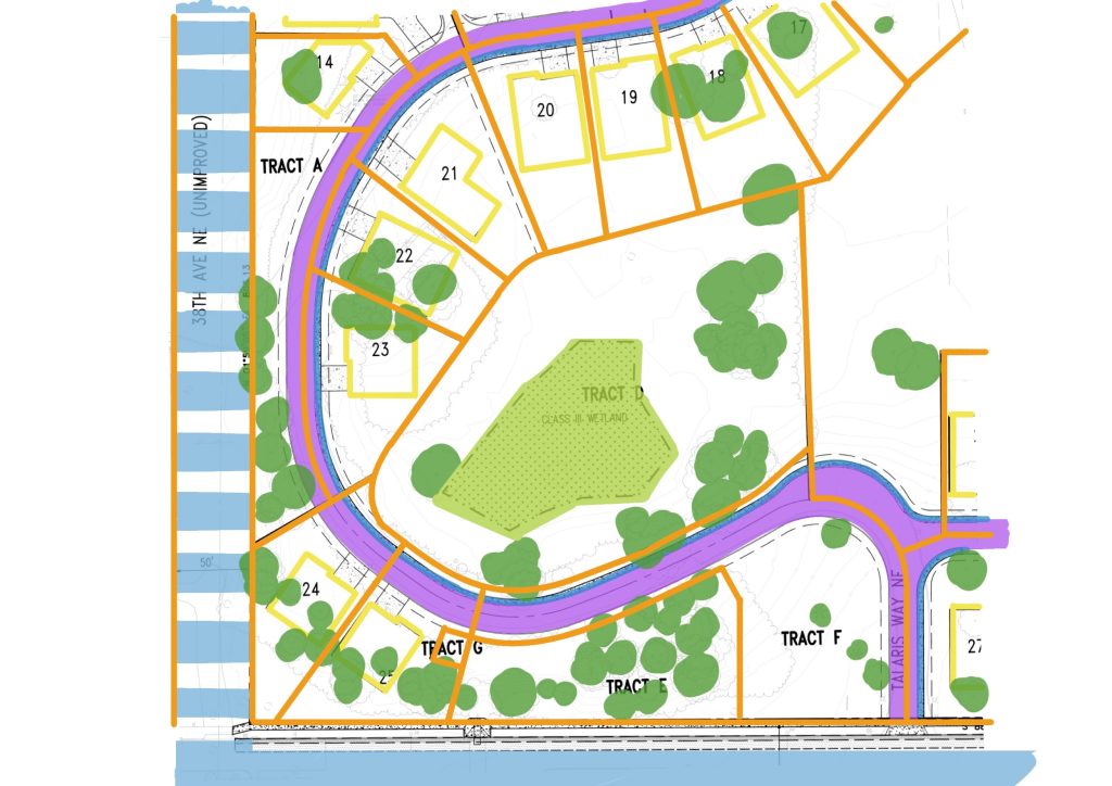
Now, that’s interesting. This corner is a solid cluster of existing trees. Not for long, though, because trees that touch the private street or the building footprints are proposed to be cut down. Most interestingly, the plan narrative that Tract A and Tract F are “open space parcels”, Tract D and Tract E are “non-disturbance parcels” and Tract G is a swage lift station. The narrative also tells us that there is an eagle nesting area on Tract E, which doesn’t need Tract G’s poop elevator for a neighbor. Let’s color them in and see if it highlights anything interesting.
That is quite revealing. What we can see is Lots 21 through 25 threading a needle through open space properties. Not just that, but the street serving these lots are cutting tons of space out of the open space tracts. Why are these lots are necessary here? The narrative also shows how parts of this area are in a stream buffer, a critical area, and a liquefaction zone. And just to be really irritating, there’s a planting strip and wedge of land owned by Lot 24 and Lot 25 on the other side of the proposed Talaris Way easement. These are legitimately terrible lots.
If we focus again on those orange property lines, we see stretches where it’s open space lots running side by side. They should be merged, removing houses and easements and lines dividing them. Larger open space tracts allow for protection of wetlands, nesting areas, and useful tree cover, not the thin lollypop trees that will be installed here. This application proposes to etch into the land record that these are separate tracts cut up by roads and property lines. It’s both unnecessary and short sighted.
By insisting on squeezing houses into this corner, the applicants force the need for a wiggling private street and the sewage pumping station. They cut apart the natural resource area for the sake of a couple of McMansions. Because this is subdivision, those cuts are permanent.
The Bigger Picture – Fight for the Future
Now we can step back and consider one more issue. Here’s the entire site colored in.
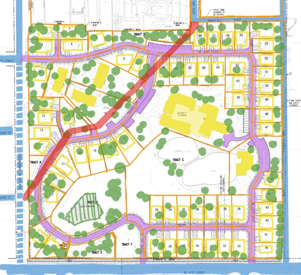
At this scale, we can see the layered private streets through the whole site, the erratically shaped lots, and the hack job division of natural resource areas. The big picture also gives us one more surprise: that wide red streak moving across the left side of the site. That’s a whole separate easement than the driveways and roads. It pushes back the houses on some of the lots and cuts across private and HOA property alike. That’s an easement for Yesler Creek running under the site in a pipe.
Yesler Creek is a north-south waterway running roughly from the Burke-Gilman Playground, across Children’s Hospital site and Talaris, then into what once was Union Bay. Like many waterways in Seattle, it is now a series of culverts except for some small portions near the Burke Gilman Trail. This easement across Talaris is one of those pipes.
Throughout the country, communities have been able to open up and restore once buried waterways. Projects like Saw Mill Creek in Yonkers, City Creek Park in Salt Lake City, and the Los Angeles River show it is possible to take a stream out of a concrete tube. Locally, Thornton Creek once ran under a parking lot, but now hosts hundreds of apartment units and a lush greenway. It’s only a few miles north of this site.
Parts of Yesler Creek itself have been restored by local groups. But the opportunity to do that across the Talaris site is fading. Once subdivided, that pipe will run under 12 new separate properties instead of one. This development means we will not see Yesler Creek daylighted in our lifetime.
The flat, indelible lines of subdivision shred this site into the personal kingdoms of 67 separate McMansion owners. More than that, this plan shreds the opportunity to do anything different for the 50-year life of these houses. That’s where we run into the most problematic part of the cheap and willy-nilly subdivision of land. It is inexpensive to cut up the land into lots, but we pay the price with the future.
Which is why it’s important that everyone can get out a set of markers and go over plans like this. It is left to us to fight for the future. We must be able to understand what it means to permanently section natural resources and public goods into tiny parcels and sell them to individual owners. The pro forma review of applications like this shows that we cannot leave this to City agencies.
The staff of SDCI is competent and well meaning but they have to be neutral when they review these applications. They have to call balls and strikes according to the rules of the game. However, as Laura Loe, founder of Share the Cities and organizer for Affordable Talaris testified at the SDCI meeting last week, “neutral is not neutral.” We are in a climate emergency, a public health emergency, and a housing emergency, all problems created under the current rules of the game. It is meaningless to call balls and strikes neutrally when half the players are naked, the other half have swords, and the field is on fire.
It is not possible to neutrally review sites like this. But we can see how by simply tracing over the lines with a highlighter, we can ask questions, look for absurdities, and stop the permanent scars that obstruct smart development and cost so many opportunities. By coloring, we get the ammunition to fight for the future. Get out your markers.

Ray Dubicki is a stay-at-home dad and parent-on-call for taking care of general school and neighborhood tasks around Ballard. This lets him see how urbanism works (or doesn’t) during the hours most people are locked in their office. He is an attorney and urbanist by training, with soup-to-nuts planning experience from code enforcement to university development to writing zoning ordinances. He enjoys using PowerPoint, but only because it’s no longer a weekly obligation.