

Sound Transit has released further information about possible alignment and station changes for the Interbay and Ballard portions of the West Seattle Ballard Link Extensions. Following comments on the Draft Environmental Impact Impact (EIS), the agency was charged to address concerns about displacements, conceptualize alternate station locations, and identify possible cost savings. Sound Transit held a public meeting to introduce the concepts on January 11 at Seattle Pacific University.
Interbay Further Studies
From the array of comments on the EIS, Sound Transit developed three modified alignments to study for Interbay. These adjust concepts from the agency’s considered EIS alternatives that built on the original preferred alignment, which was designed to emerge from a downtown tunnel at Republican Street to cross Elliott Avenue W and enter a station at Smith Cove. The original route then continued along the east side of the BNSF train yard before coming into the Interbay station north of Dravus Street.
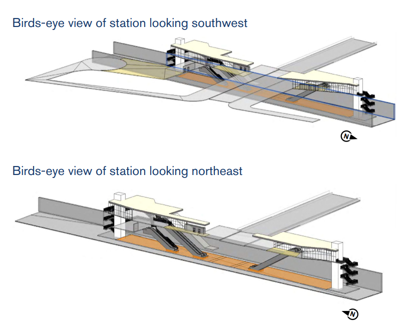
The first considered alteration is Modified SIB-1 Alignment, which refines the location of the Interbay Station to move it under Dravus as close to Magnolia as possible without crossing the rail yard. The shifted station straddles Dravus Street before going into a tunnel under Thorndyke Avenue. The alignment already raised issues with stabilizing the soils near the Interbay Athletic Complex, and the modification impacts the baseball fields in the complex while creating intermittent traffic closures to Dravus Street.
However, moving the station does avoid interference with the Seattle Storm’s proposed training facility. Sound Transit suggests that the move would save $30 million over the original concepts due to reduced property acquisition costs.
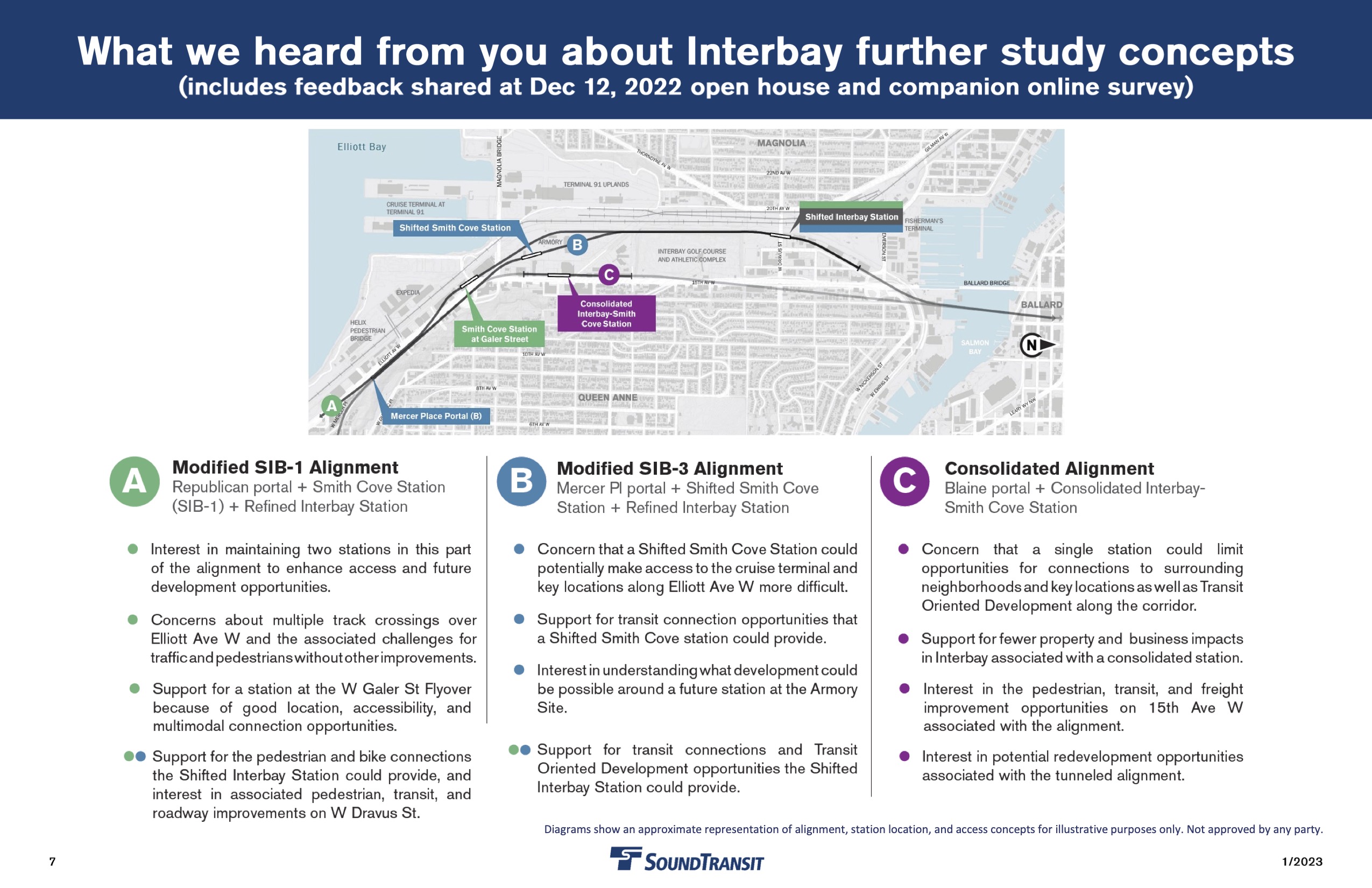
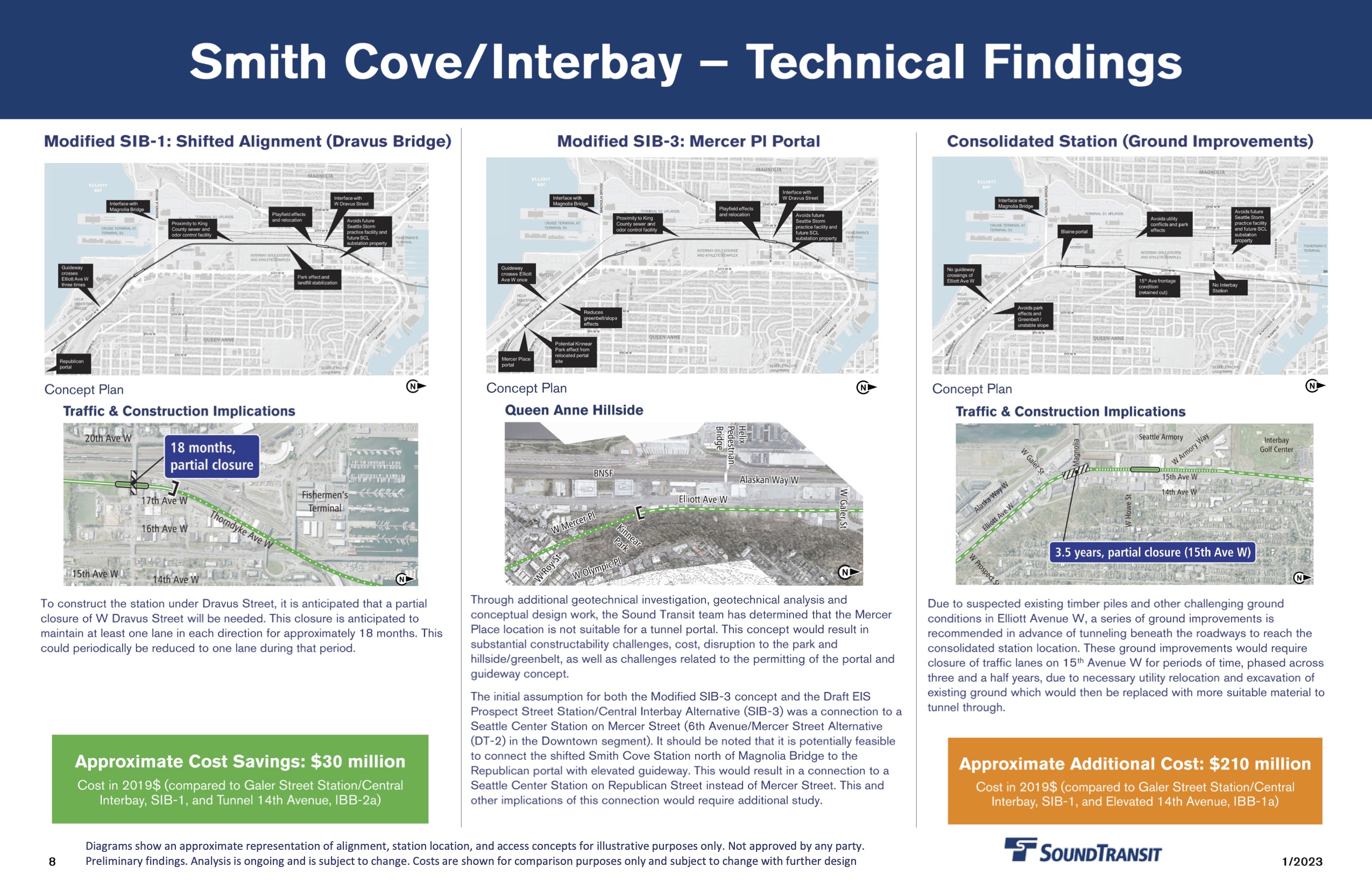
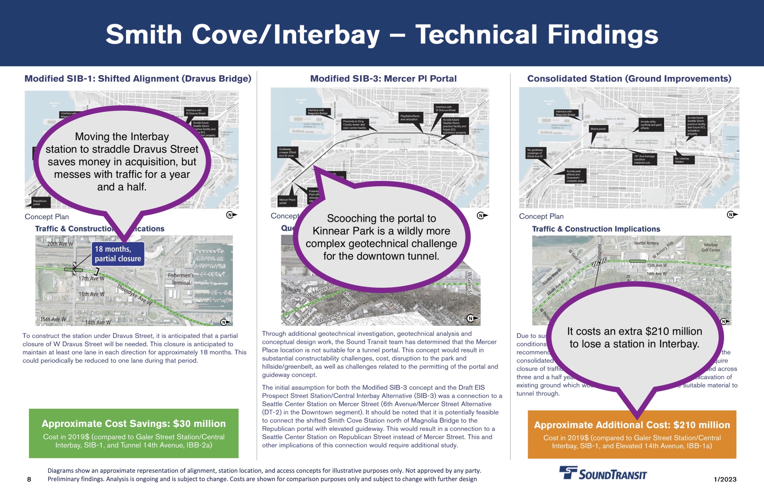
A second considered option called Modified SIB-3 Alignment examined the possibility of moving the portal of the downtown tunnel southward to approximately where Mercer Place meets Elliott Avenue, then shifting the Smith Cove station into the Armory site. No cost savings were identified because geotechnical analysis of dropping a new tunnel in Kinnear Park found “substantial constructibility challenges, cost, disruption to the park and hillside/greenbelt, as well as challenges related to the permitting of the portal and guideway concept.” Unfortunately, the analysis did not break down the costs of moving the Smith Cove station north, centralizing the station in the Armory development site.
Finally, a Consolidated Alignment was considered that replaced the two stations in the corridor with a single station located on 15th Avenue at Whole Foods. The proposed station would be below grade, constructed by “retained cut” which is digging a pit for the station and approaches from above. The alteration avoids impacting parks and some businesses.
However, analysis identified “challenging ground conditions” that would require the soil under 15th Avenue to be shored up before digging due to unstable fill soils. Partial closure of 15th Avenue at the Magnolia Bridge would occur for one and a half years. The additional cost of consolidating stations is $210 million due to the buried station amid soil issues.
Ballard Further Studies
Sound Transit’s preferred alignment into Ballard proposed crossing the Ship Canal in an elevated bridge and locating a station at 14th Avenue. Due to a U.S. Coast Guard determination heightening restrictions on impeding boat traffic in the Ship Canal first uncovered in The Urbanist, any bridge below a 205 foot clearance is required to be a drawbridge, 50 feet higher than the Aurora Bridge and equal to the Golden Gate. That massive height or mechanism requirement has driven the cost of a bridge much closer to that of a tunnel. Sound Transit considered three modifications to this plan, all of which involved tunnels.
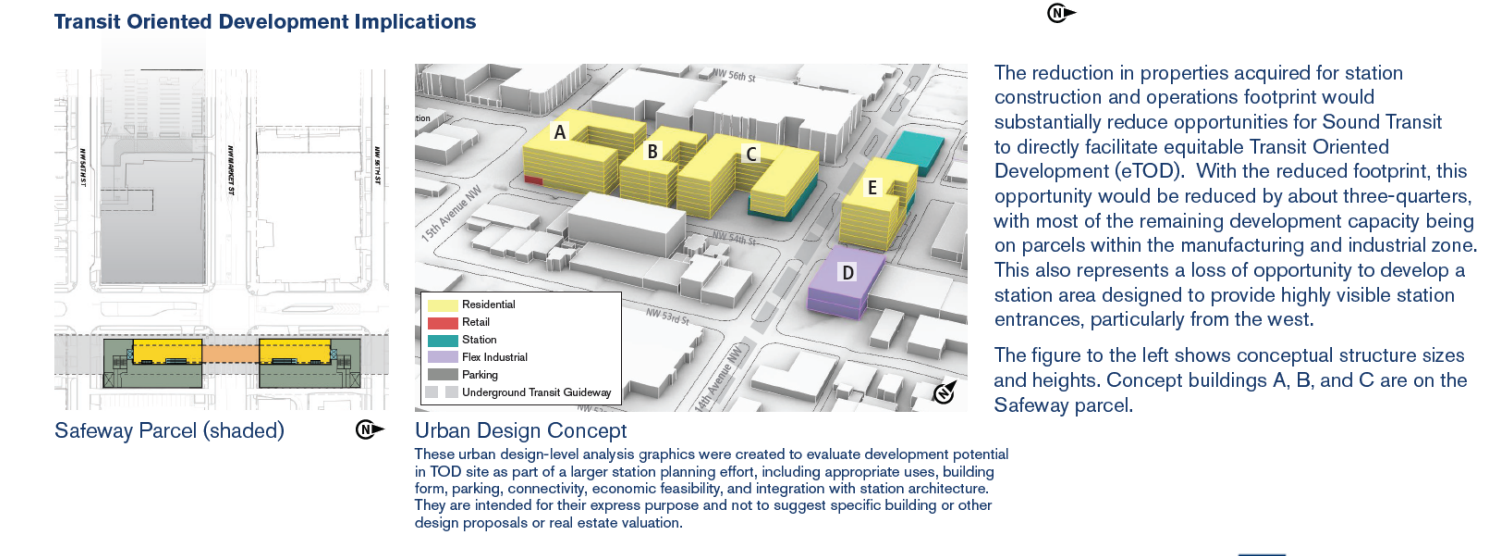
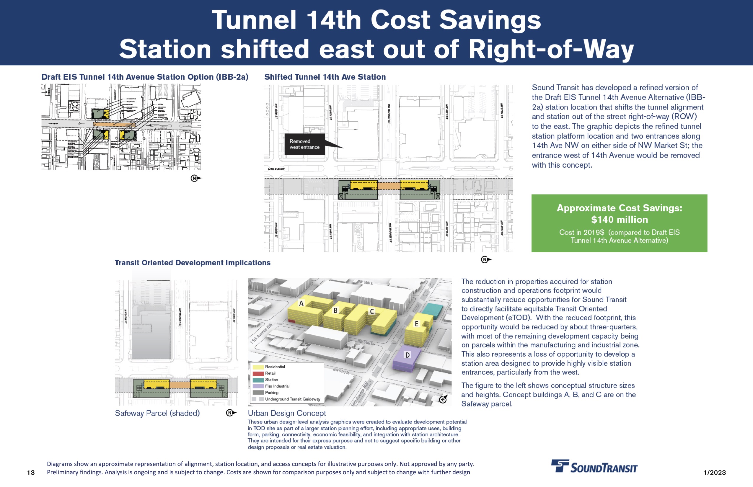
Continuing the concept of the station at 14th Avenue, Sound Transit examined a modification that moved the station out of the right-of-way of the street, instead acquiring the properties immediately east of 14th and connecting them under Market Street. Those would be McDonald’s and Sherwin Williams. Negatively, this station would be the furthest possible from the densely populated and busy center of Ballard. Sound Transit estimates the move would save $140 million in reduced utility relocations and avoiding the purchase of the Safeway site.
On the other hand, Safeway is the prime transit-oriented development site in the area and having it in public hands could be an asset down the road, with thousands of homes possible on the site.
Two other modifications placed the station on 15th Avenue, and considered whether it should be located under the right of way for 15th Avenue or to the east with connections under the road. Both alignments anticipated acquiring properties on the southeast and southwest corners of the intersection, namely the Safeway block and the Walgreens. Alignment to the east of the road would also require properties to the south of 54th Street for emergency egress. A station under the road could shift north or south by several blocks, as drawn by transit-oriented development opportunities.
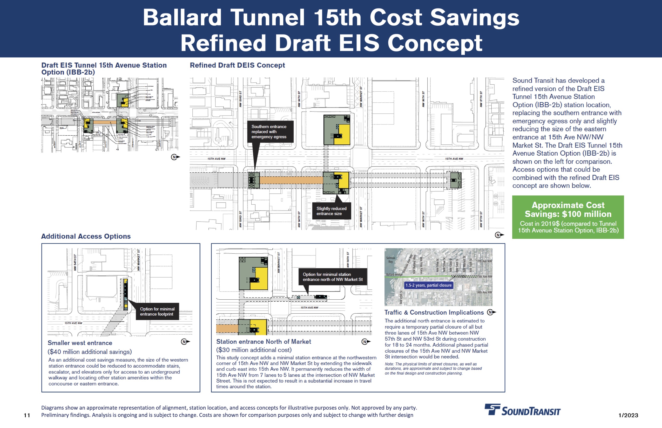
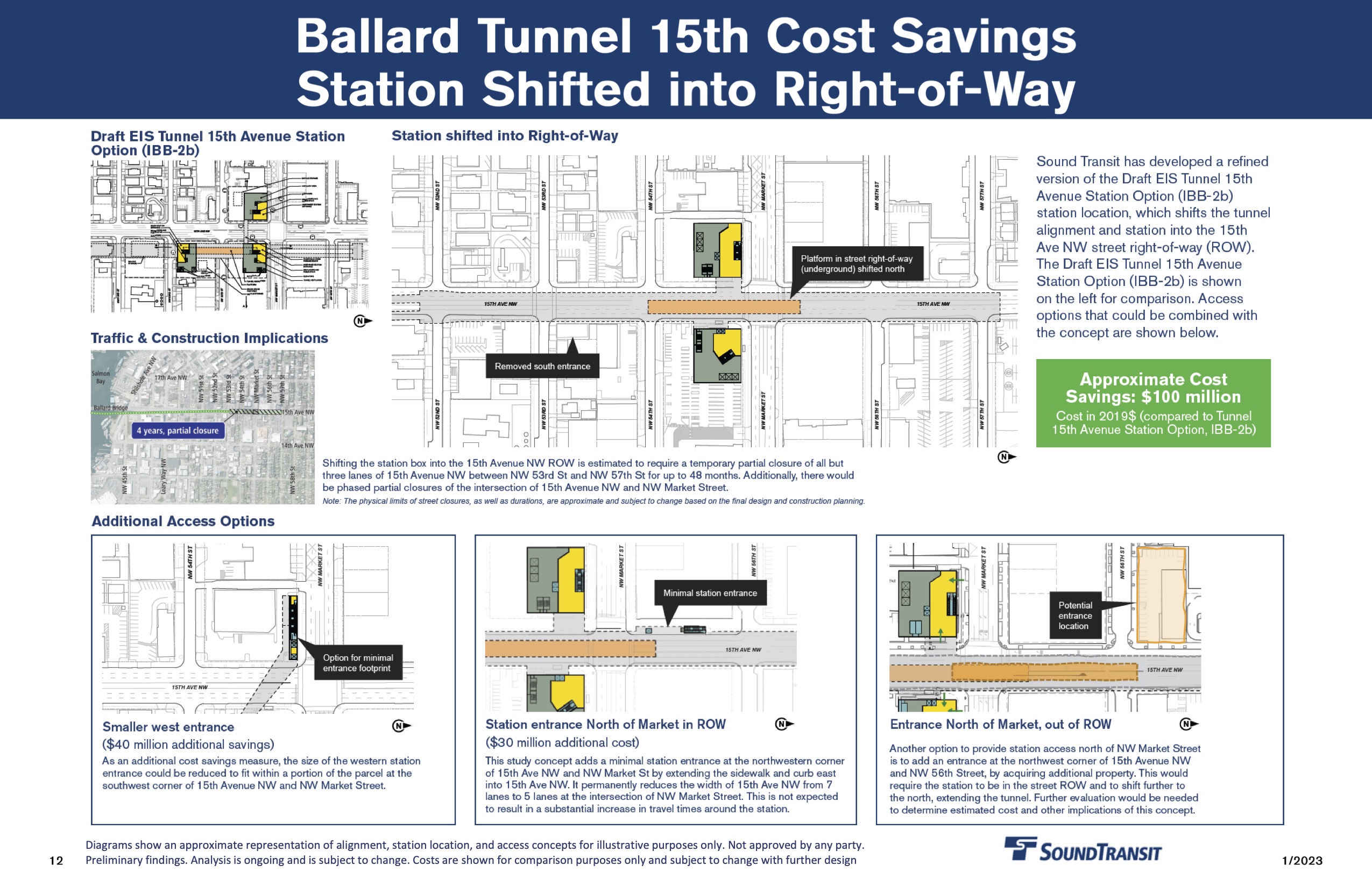
The ultimate difference between the two options is how much connection each of the above ground developments will have with the station. An east-edge station would allow only narrow tunnels from properties west. The middle of the road station creates the possibility of a broad and concourse attached to multiple above ground developments.
The most significant impact among these options is placing a station in the right of way would require partial closure of 15th Avenue over the course of four years. Both 15th Avenue options saved $100 million versus the preferred alignment. That is mitigated with every extra entrance, estimated at $30-$40 million each.
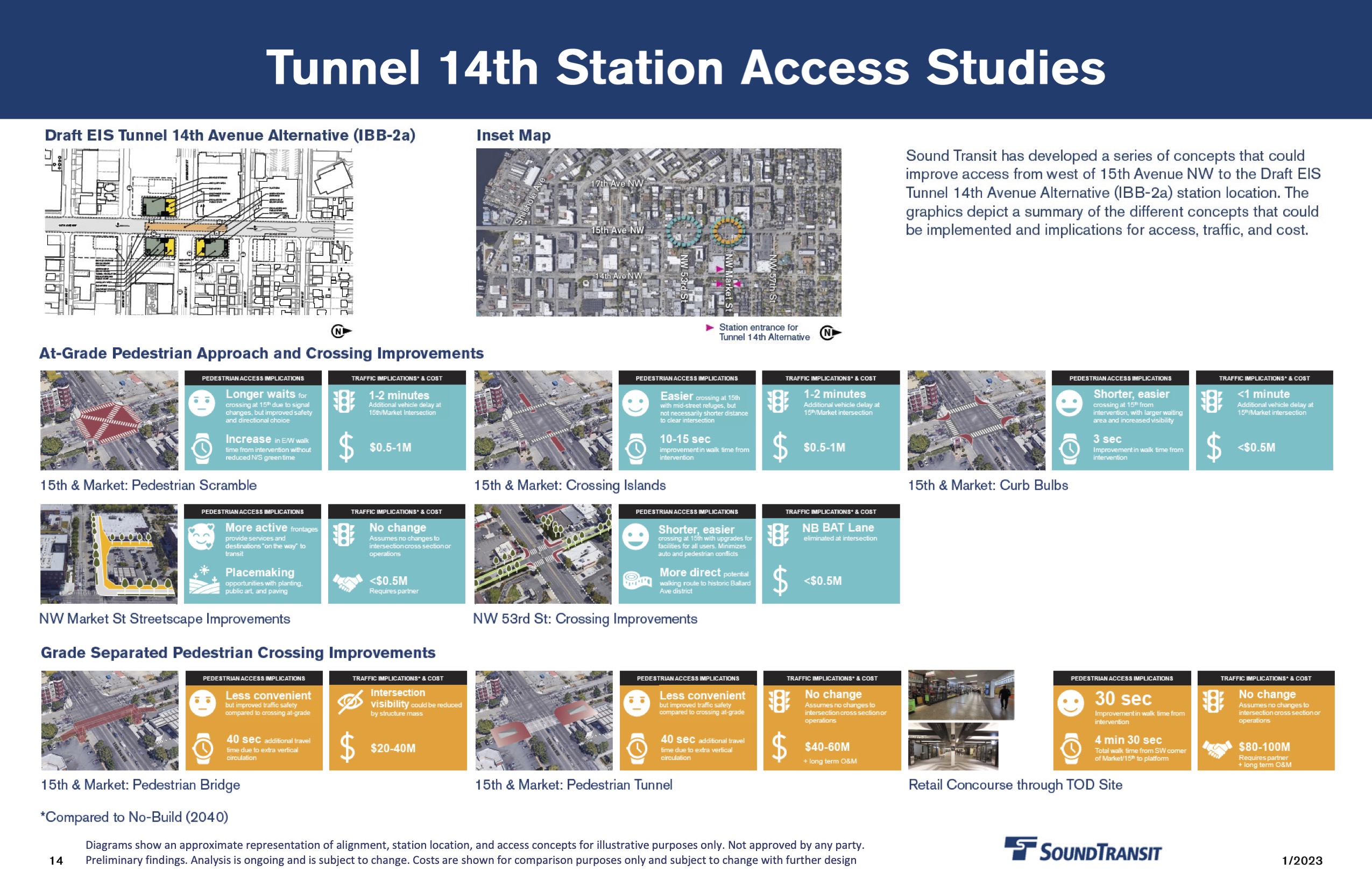
Finally, Sound Transit looked at several options for improving access across 15th Avenue, should the station end up located over on 14th. Those options included a pedestrian scramble, refuge islands, corner bulbs, as well as structures over and under the street. The on-street improvements ranged in costs but remained under $1 million. The pedestrian bridge or tunnel options are projected to run upwards of $20 million above ground to $100 million for an underground concourse.
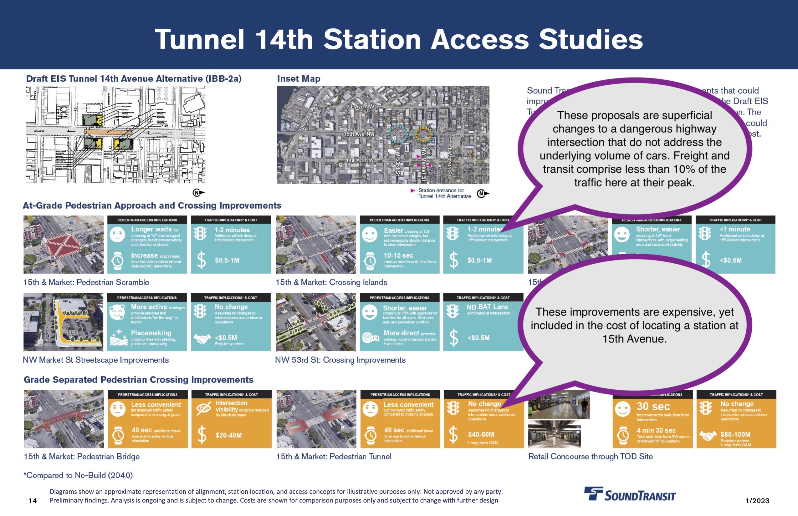
These modification appear in response to comments from The Urbanist, Seattle Subway, and like-minded advocates urging the agency to add a station entrance west of 15th Avenue or otherwise provide connection to the proposed station from denser parts of Ballard. Providing crossings on 15th Avenue adds significant costs to the agency’s preferred 14th Avenue station location, which is not included in the “cost savings” suggested by the agency’s analysis.
In all, Sound Transit’s refinements offer several interesting clarifications on specifications of stations and tunnels in the Interbay and Ballard expansion area. Cut and cover excavation is prohibitively difficult through much of Interbay due to area’s wet, wonky soils. The Ballard Station is expected to be almost two blocks long, with further open excavation north and south to allow for switch areas. And it costs about $30-$40 million to go under a street with a plain vanilla pedestrian access tunnel. These are useful discussion points as the designs are further refined.
The Sound Transit Board is expected to hear an update on these refinements at its meeting on January 26 with a deeper dive planned in February. Peruse the Ballard Interbay briefing book or Sound Transit’s webpage for more information.
Corrections and updates: This article was updated on January 23 with additional information that Sound Transit provided, including the location and duration of road closure on 15th Avenue instead of Magnolia Bridge, costs for the consolidated Interbay station, and the dates for Sound Transit meetings.

Ray Dubicki is a stay-at-home dad and parent-on-call for taking care of general school and neighborhood tasks around Ballard. This lets him see how urbanism works (or doesn’t) during the hours most people are locked in their office. He is an attorney and urbanist by training, with soup-to-nuts planning experience from code enforcement to university development to writing zoning ordinances. He enjoys using PowerPoint, but only because it’s no longer a weekly obligation.