UPDATE: Metro released formal alternatives on Thursday. The new information and maps have been updated throughout this post.
This week King County Metro and Sound Transit will jointly release two alternatives for bus service restructures to happen in 2016. The effort is intended to better connect riders with two new Link light rail stations opening one year from now, nine months ahead of schedule, in Capitol Hill and the University District. I’m a member of the citizen ‘sounding board’ on the project but the opinions here are my own.
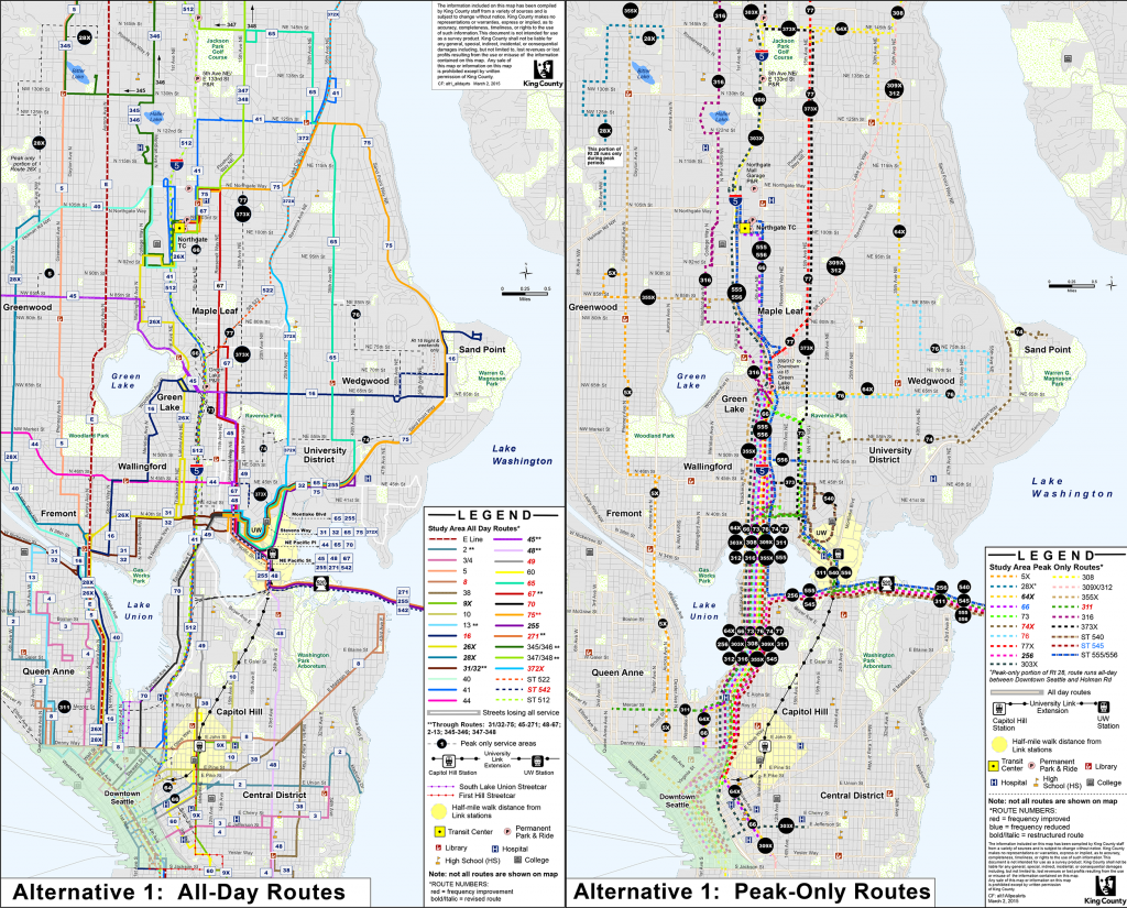
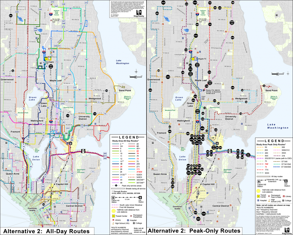
The network in ‘Alternative 1’ is an aggressive strategy of consolidation, with elimination of duplicate routes in exchange for increased frequency throughout the day. It attempts to quickly connect people with the new light rail stations, which will cut down on travel time overall. The ‘Alternative 2’ network has few changes and is similar to the current bus system, but still has some key changes worth noting.
The two alternatives encompass central and northeast Seattle and represent an equal number of annual service hours. Service hours are Metro’s currency (equal to about $150 per hour) and represent the time a bus is operating. While Seattle voters have approved buying extra service hours from Metro starting in June, this restructure process is only based off the current network. After getting public feedback this month, the agencies will come back to the sounding board to craft a final proposal for the King County Council by July.
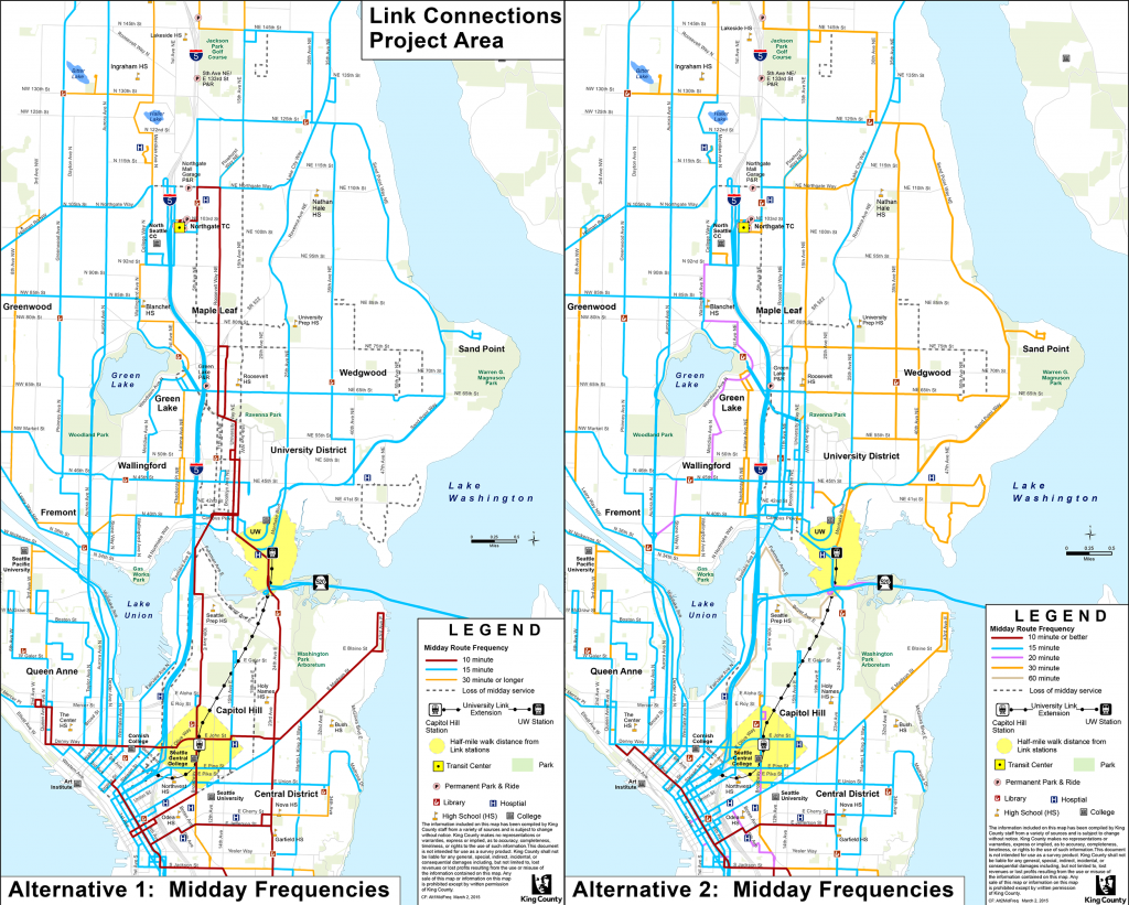
Typically, increased frequency would bring buses by stops every 10 or 15 minutes, up from every 30 or 60 minutes. ‘Peak hours’ refers to commuting times of 5-9am and 3-7pm, with peak-only routes being those that only operate during those hours. ‘Midday’ is in-between and ‘night’ is after 7pm.
Alternative 1
The following are route deletions under Alternative 1, and in parentheses are the frequency adjustments to the routes riders would use instead.
- 11 (8 has increased peak, midday, night, and Sunday service)
- 12 (west of Broadway, 49 has increased midday and night service; east of Broadway use 8, 10, or 38 to reach light rail)
- 25 (255 local is unchanged, and 255X is now peak only)
- 26X (combined with local 26)
- 28X (combined with local 28)
- 30 (74 is unchanged)
- 43 (8 and 48 provide alternate service; 48 has increased midday, night, and Sunday service)
- 68 (372X has increased all day service and new weekend service)
- 71 (Link goes to downtown, and 16 has increased all day and weekend service)
- 72 (Link goes to downtown, and 372 is upgraded to all day, all week service)
- 242 (66 is make peak only, and 542 has increased service all day and all week)
- 252 (311 has double the number of peak trips)
- 257 (311 provides alternate service)
- 277 (255 provides alternate service)
Other than those listed in parentheses above, the following routes would also see increased, decreased, or rerouted service:
- 26 (routed down Aurora Avenue instead of Dexter Avenue)
- 28 (routed down Aurora Avenue instead of Dexter Avenue)
- 64X (one additional afternoon trip and goes through South Lake Union and First Hill)
- 65 (increased midday and Saturday service, and serves UW station at Pacific Street)
- 66 (made peak-only and no longer serves U-District, going down I-5 to First Hill)
- 70 (increased peak service, and added night and Sunday service)
- 73 (downgraded to peak only trips between Roosevelt and downtown)
- 75 (increased midday and Saturday service)
- 76 (additional peak trips)
- 235 (extend north to Brickyard Park and Ride)
- 238 (extended to Woodinville Park and Ride)
- 255 (split into two routes, one connecting Totem Lake with Seattle Children’s hospital; a new 256 connects Kirkland with downtown Seattle during peak only)
- 271 (split into two routes overlapping in Eastgate; western part has increased night and Saturday service, and east part is a new route 207 downgraded to only peak and midday service)
- 311 (rerouted through U-District and terminates at Seattle Center instead of downtown)
- 316 (added peak only trips)
- 540 (rerouted via Houghton Park and Ride)
- 542 (upgraded to all day, all week service and terminates at Bear Creek Park and Ride)
- 545 (made peak only and terminates at UW station)

And along with scheduling changes, a number of routes would be realigned. This includes some Metro and Sound Transit routes on the Eastside; see this map for Eastside routes. The most significant route changes in Seattle are listed below with commentary on those routes I am most familiar with:
- The 8 is split into two routes overlapping at the Capitol Hill Link station. The southern part, a new route 38, connects Martin Luther King Jr. Way with the northern end of Broadway. The northern part still connects Uptown with Capitol Hill via Denny Way, and extends east to Madison Park to replace the deleted 11. Nicknamed the Late, sounding board members were skeptical that increased frequency on the north part will benefit anyone because of how congested Denny Way is. One option to solve this, and also give South Lake Union better east-west service, is to route the 8 via Harrison or Thomas Streets instead.
- The 16 serves Sandpoint instead of Northgate, and takes a meandering route to downtown via the Fremont Bridge instead of Aurora Avenue. It has increased frequency across the board. The 26 fills in the gap between Green Lake and Northgate created by the 16 reroute.
- The 48 is split into two routes that overlap in the U-District and Roosevelt neighborhoods, with both serving UW station. The northern branch is a new route 45. This makes sense, as the current 48 is one of the longest routes in Seattle and it’s unlikely many people ride the full length. However, it is proposed to move from 15th Avenue to University Way (The Ave), a much narrower street. I will go into this issue more below. There is inconsistency on whether in Alternative 2 it serves the Roosevelt corridor not.
- The 49 accesses downtown via Madison Street instead of the Pike-Pine corridor.
- The 66 becomes peak only between Northgate and First Hill via I-5 instead of going to the University of Washington and downtown.
- The southern part of 67 runs on The Ave and terminates at UW station, continuing as the 48 southbound. The station connection is great, but it shouldn’t be at the loss of service for the south Roosevelt corridor, a growing commercial and residential area. Plus, SDOT is about to build curb extensions for buses here; under this proposal those improved bus stops would be wasted.
- The northern part of the 70 terminates at the UW station instead of serving the entire western edge of the UW campus on 15th Avenue. Staff indicate this is to connect the UW Medical Center with South Lake Union. But there are already UW and private shuttles that provide the same service. Plus, many UW students live in Eastlake. The 70’s increased peak service to 10-15 minutes is great, but if should retain its current route.
- The popular 71, 72, and 73 are significantly changed, with the first two deleted. Routes 16 and 372 connect the Wedgwood and Lake City neighborhoods that lose 71 and 72, respectively, with the university. The light rail is intended to provide the bulk of capacity on the busy U-District to downtown corridor. The 73 becomes peak only, with eight trips in the morning and ten in the afternoon, between Green Lake and downtown via The Ave and I-5 express lanes.

Alternative 2
Alternative 2 would have much fewer changes and is focused more on geographic distribution, with less frequent service and greater transfer times. Some changes are made to serve destinations based on public feedback last year. General service and realignment changes are listed below.
- The 25 is retained and split in two to serve Portage Bay and north Capitol Hill, overlapping at UW station. A new route 62 connects UW station with Laurelhurst.
- The 30 is still deleted.
- The 66 is deleted.
- The 67 is deleted.
- The 68 is retained but rerouted along 75th Street and 40th Avenue.
- The 71 is retained but only becomes a short east-west route between Magnuson Park and Green Lake.
- The 72 is still deleted.
- The 73 is retained with increased service across the board, but only goes as far north as Northgate.
- The 74 is two-way during peak.
- The 238 is extended to Woodinville Park and Ride.
- The 242 is still deleted.
- The 277 is still deleted.
- The 372 is still upgraded to frequent all day and all week service.
- The 373 is upgraded to to all day, two-way service.
- The new 541 would be peak only between Overlake and U-District.
The Takeaway
Alternative 1 is a great start to a higher frequency network for the people of north and central Seattle. It will require some riders to walk further to their stops, which many will probably consider worthwhile if the bus schedule is more robust. But in places with steep hills, poor or non-existent sidewalks, and other safety issues, the city should improve walking facilities. The consolidation of routes and stops could also allow unused stop shelters to be reallocated. Keep in mind that the opening of three more light rail stations only six years from now will necessitate another major network restructuring.
There are also maps available of travel times between various destinations under each alternative, factoring in the Link service. Under Alternative 1, travel times from the northeast neighborhoods to Capitol Hill will significantly improve. It’s a mixed bag in terms of travel time from those neighborhoods to downtown and South Lake Union, while there will no time advantage in getting to the University District from the north. Under Alternative 2, it’s also a mix of travel time advantages from points north to the south, with some places experiencing much slower travel times. These are very general observations, check the travel time maps on Metro’s website for details.

I have a particular concern with routes in the core of the U-District. Because 15th Avenue has double the lanes, wider sidewalks, and no on-street parking, I believe it should continue to carry the bulk of north-south bus routes in this area. There is potential to establish bus-only lanes. It also quickly connects students, the majority of riders in the area, with the university campus. Metro funded a makeover of The Ave’s streetscape a decade ago, and so are understandably reluctant to abandon it. But what’s best for the growing community here is to retain The Ave’s special and eclectic retail character. Converting it into a pedestrian mall, is a possible game changer. Getting buses off now, or at least reducing their number, would help build momentum for such an endeavor. But a transit-pedestrian mall may also be worth studying, especially if the streetcar comes back to town.
In response to this specific issue, Metro staff provided the sounding board with travel time data comparing 15th Avenue and The Ave between Ravenna Boulevard and 41st Street. The Ave wins out by a minute most of the time and up to two minutes during peak. But this isn’t a fair comparison. The Ave has one less traffic light (41st Street) and one less bus stop (52nd Street), making it naturally faster despite parking cars, mid-block crosswalks, and bicyclists slogging uphill. Plus, the minute or two speed advantage doesn’t matter for the vast majority of riders, who are heading to or from campus, if Metro makes them walk an extra block and wait to cross 15th at a light. Metro should, in short, prioritize 15th for bus service.
Early on I was also concerned with bus-to-rail transfers through the Montlake Triangle area, which was designed for high speed car traffic. Fortunately, Metro, the city, and the UW are taking a hard look here. Bus stops on Pacific Street will be moved closer to the south intersection, beg buttons will be removed, and stops may be consolidated on Stevens Way. Bicyclists won’t have an issue making a quick connection to the new Rainier Vista or Burke Gilman trail, but pedestrians will still have to walk several hundred feet. Wayfinding, shelter, and lighting investments could improve the experience if the agencies commit to funding them.
That’s my take. Check out the maps and Metro’s website, which has much more information, and let me know what you think and which changes would better serve the citizens of Seattle. Look out for Metro’s announcement this week of the public process, which will include online components and community meetings, and for the analyses of other local blogs who can dig into deeper details.
This article is a cross-post from The Northwest Urbanist, the personal blog of Scott Bonjukian. He is a graduate student at the University of Washington’s Department of Urban Design and Planning.
Scott Bonjukian has degrees in architecture and planning, and his many interests include neighborhood design, public space and streets, transit systems, pedestrian and bicycle planning, local politics, and natural resource protection. He cross-posts from The Northwest Urbanist and leads the Seattle Lid I-5 effort. He served on The Urbanist board from 2015 to 2018.


