Most recently I have taken on a new venture in which I am dedicating my career to helping cities plan for autonomous vehicles (AVs) and other disruptive transportation technologies (e.g., drones, electric vehicles, and hyperloop). My startup is called Smash the Box Planning, where we smash the box instead of thinking outside of it.
For the meantime, I’ve started Uber driving in Seattle. After driving around the city for a couple of weeks, I realized that Uber drivers can play a huge role in planning our cities for self-driving cars.
Typical Ride
A typical Uber Driver ride consists of these four steps:
- Uber customer requests a ride.
- You accept the ride and drive to where they are located on the map.
- You pick up the rider.
- Travel to the destination in which you then drop off the rider.
Understanding what a typical ride consists of really opens up your eyes when observing the urban landscape as an Uber driver.
What Would an Uber Self-driving Car Look Like in a City?
Uber is more or less so like renting out your car, but with self-driving cars you would just imagine taking the human driver out of the equation. Taking those main functions of a typical ride from requesting a ride via your app, to the car self-navigating itself to you, then picking you up, and driving to your final destination for a drop-off is valuable information that an uber driver’s knowledge and experience can help us plan our cities for AVs. This is inclusive planning that allows for drivers to have an input on issues and concerns they believe need to be identified. This is also sustainable planning, because of how Uber drivers are well-equipped with navigating the streets of urban areas, so by having them help us design our roads will allow us to identify the most common issues and concerns, and in return planning for an AV future that will mitigate unforeseen issues.
For the sake of keeping this article short, I’m just going to focus on the key assets that an Uber driver acquires from driving, but also highlights elements for designing cities for AVs: maps, data, major events, and drop-off and pick-up zones.
Maps
As an Uber driver you start becoming very familiar with the city and essentially learn the city inside and out. Because Uber acts as a way for you to achieve your first and last mile trips, the Uber driver gets to learn different neighborhoods, peak hour times, street designs, and over time become less dependent on Uber’s Google Map for navigating the city.
Disclaimer: I should probably mention that I have 10 years of experience in GIS and a B.S. in Geography, so yes, this is a legit evaluation on Uber’s maps.
May I also note that Uber’s Google API is far from perfect. There are some Uber drivers that rely on this map and use it step by step, which makes me think of all the issues that would arise from self-driving cars following a map that leads you to deadends, drives you into jersey barriers, or better yet ends up being the self-driving service that believes that the blue on the map is land.
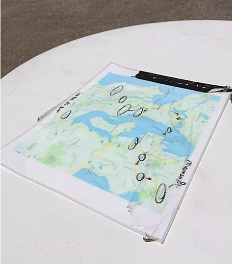
This is the Uber Map used for Uber’s driving test in Seattle. Before you can begin driving, you have to take a test that highlights the major geographic areas in the city.
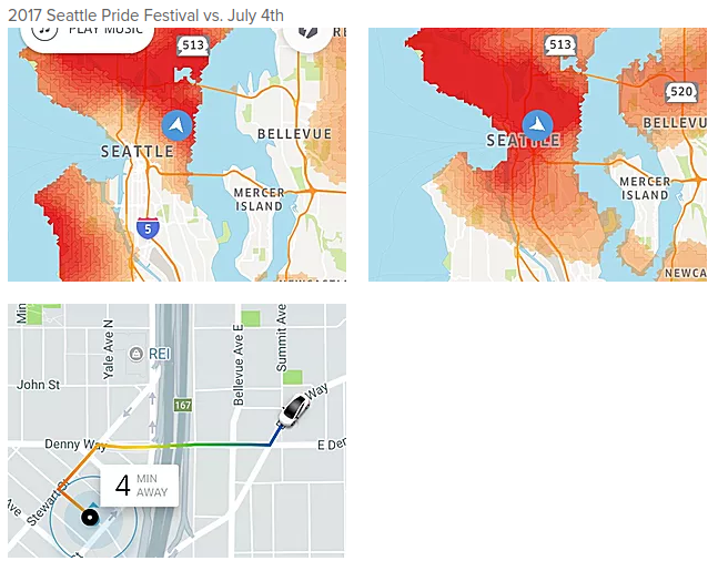
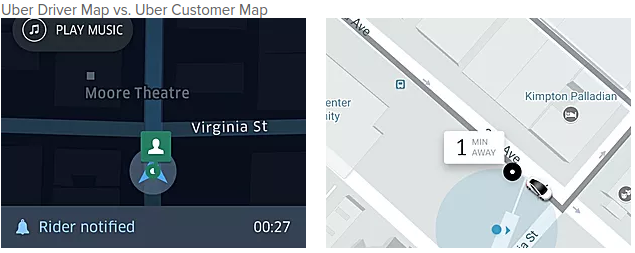
The Uber Driver Map, which is shown below, identifies the supply and demand of where Uber drivers are needed to meet demand of people requesting uber. The greater the demand equals darker red/orange and vice versa. Because of the high demand and lack of supply, Uber has created an incentive where Uber customers pay a higher price (surge) in order to have someone pick them up. From my analysis when Uber drivers chase the surge then you create another pocket of demand in the area in which you just left. Note: Never chase the surge because it can be gone within two minutes. Although if there is a major event, then you’ll find that the demand is high and the supply is going to be needed all throughout the day. The surge is likely to be there for more than a couple of hours.
Another concern that I have for Uber’s maps is that sometimes the directions given to the Uber driver make zero sense. Here are two examples of the Uber Google Map API using an algorithm that tells the driver to take a route that is the most efficient based on a number of factors, but the main factor being congestion. Road congestion is shown in three colors: red (heavily congested), yellow (moderately congested), and blue (light/no congestion). Road congestion is based off of the Google API which is an algorithm created from clustering Android users that are located within a certain radius. What I’ve noticed is that you’ll sometimes see that bars with crowds of people will trigger the Google API to label the road as heavily congested, but the road will be clear of traffic.
How exactly are Uber Autonomous Vehicles designing their High Definition Maps for their vehicles to navigate the roads must be evaluated by Uber Drivers in order to provide well thought out methods for AVs picking up and dropping off passengers.
Data
With policies that promote open source data for sharing purposes will help serve as major asset in solving congestion problems in a feasible manner. Policy recommendations such as the National Association of City Transportation Officials (NACTO) provide recommendations that allow for creating data-sharing requirements for automated vehicles (NACTO, 2016). Open souurce data provided from the self-driving car industry could help solve the supply and demand issues (fleet optimization) for public transit. Similar data sharing policies like Seattle’s bikeshare program policy (Seattle Bike Blog, 2017) has allowed for partnerships with educational facilities to meet their mission of providing accessibility through mobility by creating a transportation data repository.
So when major events such as Seattle Pride or July 4th happen, this shared data can help alleviate our LA-esque traffic, for example Mercer Street during peak hours. That’s right, this street has its own blog, because of its infamous traffic.
How to cross pollinate Uber drivers into the data field? Well, Uber drivers can help prioritize what data would be most helpful in utilizing for navigating AVs onto our roads. Drivers can identify what is needed and what is not needed when collecting this big data from government and private transportation infrastructure.
Major Events
When a city has a major event, Uber will notify you of the event and it’s all you from there in order to pick up passengers left and right. As one can imagine, navigating the roads at this time should be done by someone who knows their way around. Given my educational and professional background in transportation planning and living in Seattle for over a year, driving in this city during these times can be compared to LA traffic.
Seattle’s Pride Festival in 2016 included over 500,000 people and this year’s Pride festival was estimated to be about 200,000 folks. One of the reasons that the crowd numbers decreased was because we had record breaking heat during that weekend. These numbers have an direct impact on road congestion. So when it comes to picking up folks, you have to be in and out. Drop-off and pick-up zones can be seen as one of the main urban design elements needed to be addressed in planning our cities for self-driving cars in order to help decongest roads during major events and peak hours.
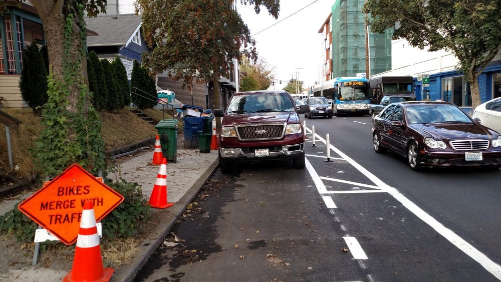
Drop-Off and Pick-Up Zones
I’ve noticed that a lot of times Uber customers do not bother to acknowledge where they place their pin on the map in order to have someone pick them up. Just like the rest of our American cities, Seattle’s roads were not prioritized to be designed for pedestrians. So when it comes to drop-off and pick-up zones, Uber drivers know how important it is to make sure that the passenger and driver are located in a safe area when loading and unloading passengers.
Remember how I talked about the importance of maps and data? Well, this also would help with drop off and pick up locations. Knowing real live time data of where streets are closed will help with not allowing the Uber Google Map API to tell the Uber driver into situations like this.
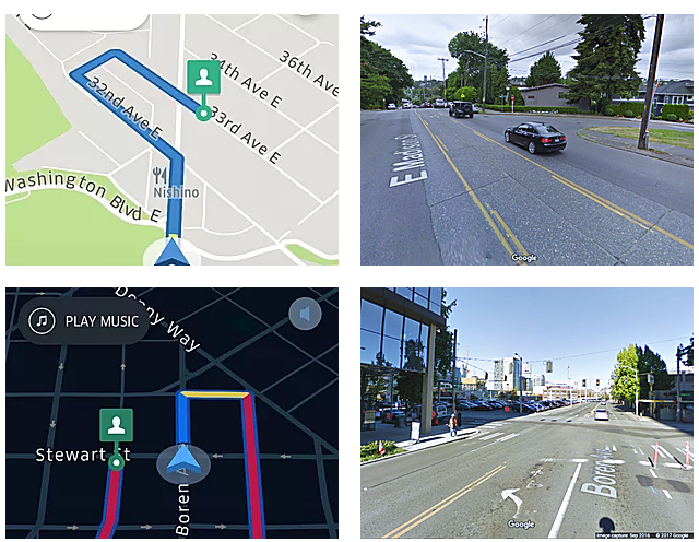
Example 1
Here’s one example where the Uber Driver App Map allowed the customer to drop a pin in an area that was on a closed road.
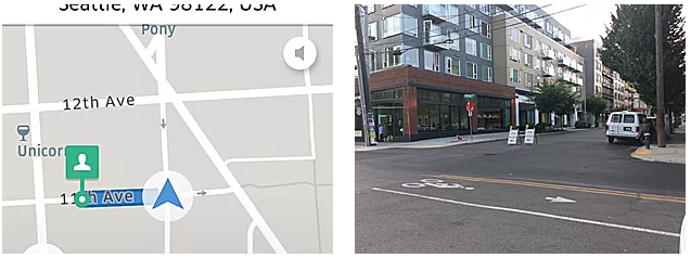
As an Uber driver, you have the decision of breaking the law to get to the customer, or you can park somewhere close by and wait just two to five mins more for the customer to find you. What needs to be addressed here is that your decision must make sure the pedestrian and yourself are safe in whatever you decide in moving forward with picking up the customer.
Example 2
Uber has recently started telling customers to drop their pin on the map for their pick-up location near street block corners. I understand that Uber is trying to provide ease on the Uber driver and customer, but understanding that this causes more congestion and is not safe for both parties.
This places the Uber driver to increase their risk of getting hit by other cars that are turning into that lane from another lane. It also blocks anyone from turning into that lane and causes more congestion.
I found that two of the major economic drivers in the City of Seattle have designed their spaces to accommodate pedestrians. Both Amazon and Microsoft are well-known to bring the tech professionals without cars into our region. This allows for Uber and other ridesharing companies to have an abundant demand for use of their services. These entities have exclusively designed their entrances to their buildings with drop-off and pick-up zones.
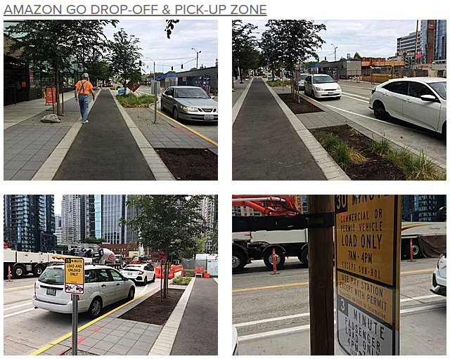
Here you’ll see that there is a clear delineation between parking to drop-off and pick up passengers by its design. With legible easy to read sings, yellow painted curbs, and vegetation between the car and righa-or-way this makes for good design. My only critique here would be to add more color to the overall design of the right-of-way. It seems to have a neutral color palette, and can lead to human and AVs not familiar with this area to drive onto the right-of-way.
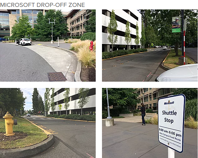
You can see here that Microsoft has a similar design, but nonetheless a design that allows for plenty of vehicles to drop-off and pick-up pedestrians. Signs, painted curbs, and size are pretty similar to Amazon Go’s drop-off and pick-up zones.
I strongly believe that putting as many stakeholders at the table who would be involved with designing our streets for self-driving cars is the way to go. One of the main key stakeholders in designing our roads for the new disruptive technology involves the people who use them everyday. It’s not just only Uber drivers who need to be involved in this conversation, but drivers who work in public transit, taxi drivers, Lyft drivers, single driver commuters, and others who can help identify the key issues, such as creating intelligent high definition maps, figuring out what data would be best used, and locating drop-off and pick-up zones that will be safe and sustainable for all. This is just one way to plan inclusive, sustainable, and innovative designs for Autonomous Vehicle cities.
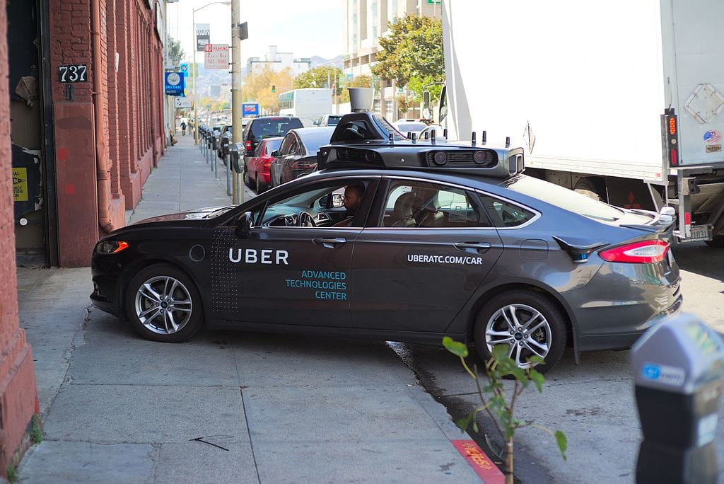
The featured image is an autonomous Uber prototype in San Francisco. (Photo by Dllu via Wikipedia Commons)
Yes Segura is an autonomous vehicle transportation planner, urban designer, and cartographer. He has devoted his career to planning cities for self-driving cars and worked with the Florida Department of Transportation on identifying policies and infrastructure investments for the State of Florida. That work earned a National AICP award and inspired him to start his business Smash the Box Planning, where he helps cities plan for AVs and other disruptive transportation technologies.
This article is a cross-post from Yes Segura’s personal blog.