
Tacoma has taken another step in its land use reform process to equitably house people and undo a legacy of exclusionary zoning. Home In Tacoma — an equitable affordable housing strategy — advanced beyond the Tacoma Planning Commission last week on a 6-3 vote in favor of recommendation. A chief piece of the recommendation is a deep revision to the future land use map — an element of the city’s comprehensive plan — affecting single-family and multifamily zoned areas of the city.
The commission also recommended that the Home In Tacoma project be phased in two parts, slowing down the timeline a bit and making the reforms more digestible. Under the phased approach, comprehensive plan changes and some near-term land use code and programmatic changes would be adopted in the first phase. Deeper land use code policies and zoning changes would follow in the second phase.
The planning commission’s recommended map revisions are essentially a hybrid of two map alternatives shared with the public in March and April. The recommended map would still direct land use and zoning changes for all areas zoned single-family and multifamily in Tacoma (all other zoned and designated areas are excluded from changes). If adopted, this would essentially end the concept of single-family zones in the city in both name and regulation. Single-family areas would be redesignated and rezoned to Low-Scale Residential or Mid-Scale Residential zoning types, which would permit a mix of housing types like duplexes, rowhouses, and apartments. Low-Density Multifamily areas would also get a boost to Mid-Scale Residential, a more intensive land use designation than the current one.
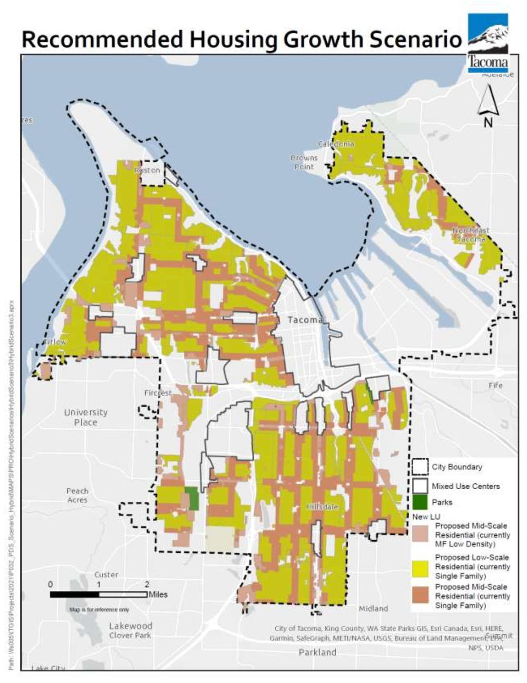
The planning commission received extensive feedback on the initial map alternatives released in March with about 900 comment submissions. Responding to this, the planning commission wanted to refocus the most intensive map changes within one to two blocks around neighborhood centers, transit corridors, and other main corridors. The commission toyed with several hybrid alternatives before settling on the recommended map last week. As a result, the recommended map generally connects Mid-Scale Residential areas by way of main corridors in a grid-like fashion. In between, Low-Scale Residential predominates as the primary land use designation. Overall, this shakes out as something like 65% Low-Scale Residential and 35% Mid-Scale Residential.
Functionally, the difference between Low-Scale Residential and Mid-Scale Residential is density level, building height, and allowed uses. The following is how that could shake out based upon draft comprehensive plan language:
- Low-Scale Residential areas would generally allow up to three stories in height, 10 to 25 dwelling per acre, lots as small as 2,500 square feet, and a mix of housing types ranging from detached houses with accessory dwelling units and duplexes to fourplexes and small-scale apartments.
- Mid-Scale Residential areas would generally allow up to three to four stories in height, 15 to 45 dwelling units per acre, and a mix of housing types ranging from small-lot houses and triplexes to cohousing, fourplexes, and apartments.
This is contrasted with Single Family Residential and Low-Density Multifamily areas in the comprehensive plan that are much more restricted in what is possible for corresponding zones.
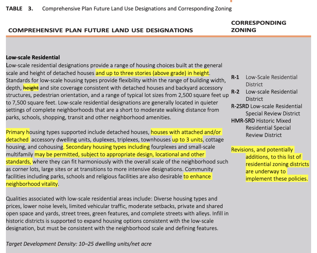
Draft Low-Scale Residential land use designation description text for the comprehensive plan. (City of Tacoma) 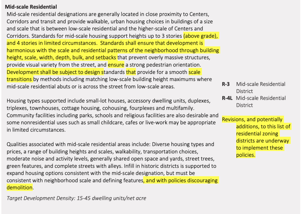
Draft Mid-Scale Residential land use designation description text for the comprehensive plan. (City of Tacoma) 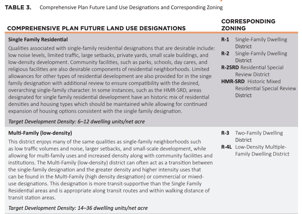
Existing Single-Family Residential and Low-Density Multifamily land use designation description text in the comprehensive plan. (City of Tacoma)
Additionally, draft language for the comprehensive plan offers a bit more clarity on corresponding zoning designations that could be applied to Low-Scale Residential and Mid-Scale Residential. Low-Scale Residential would come in two basic flavors (R-1 and R-2) plus a special review district (R-2SRD) and historic mixed district (HMR-SRD) while Mid-Scale Residential would come in just two varieties (R-3 and R-4L).
As a two-phase process, the planning commission recommendation calls for the first phase to focus on the future land use map changes, near-term land use code changes, and some other updates to the comprehensive plan. Here’s how those shake out:
- On the land use code front, the recommendation directs an update to accessory dwelling unit regulations to remove barriers to development and parking requirement reductions for senior housing. It also outlines a new affordable housing development bonus for religious institutions and nonprofit housing developers, an expanded development agreement pathway for projects that would deliver affordable housing, and a streamlined approval process for subdivisions.
- In the comprehensive plan, the recommendation seeks to redirect housing policies and the city’s vision for housing growth. It does this by revising language toward inclusive and diverse neighborhoods, increased housing options, replacing the Single-Family Residential and Low-Density Multifamily land use designations with Low-Scale Residential and Mid-Scale Residential, and removing the narrow definition of “family”. Coupled with this is additional language that promotes general design strategies (e.g., accessibility, pedestrian orientation, transitions, and landscaping) and preservation strategies of historic structures.
- Also in the comprehensive plan, the recommendation touches on affordable housing and anti-displacement strategies. An inclusionary mandatory affordable housing policy, affordable housing requirements in federally-designated Opportunity Zones, and policy to incentivize more family-sized units are outlined in the revised language. In tandem with this, the recommendation also seeks to expand use of the city’s Multifamily Tax Exemption Program for the 12-year affordable housing option outlined in state law.
The second phase of the process will be much more focused around the nuts and bolts of zoning and development standards, which could set up high stakes disputes about which properties get what zoning, how transitions between zones should work, and what the right design approach should be. That process will involve deep public engagement to suss those issues out, but is also slated to look into other topics like actions to encourage retention of existing structures, green building, accessibility, and permitting processes.
Two planning commissioners who voted against the recommendations disagreed with map changes in the North End and Northeast Tacoma, arguing that the changes went too far. This is not exactly surprising given the over-the-top reactions some North Enders had at the maps. Another commissioner who voted against the recommendations apparently felt that the maps didn’t accurately reflect transit corridors as they exist today even though Tacoma has future transit corridor plans.
With the recommendations in hand, the process moves over to the city council where roadblocks could begin to appear, depending on public feedback. The city council will initially hold a study session on June 8th with planning staff presenting the planning commission’s recommendations. City councilmembers will have an opportunity to provide guidance at the meeting and could call for additional study sessions and setting of a public hearing date to adopt legislation memorializing the phased planning process and adoption of the first phase’s recommendations. Once the first phase of the Home In Tacoma process is completed, planning staff will be able to advance work on the second phase, which is expected to run into 2022.

Stephen is a professional urban planner in Puget Sound with a passion for sustainable, livable, and diverse cities. He is especially interested in how policies, regulations, and programs can promote positive outcomes for communities. With stints in great cities like Bellingham and Cork, Stephen currently lives in Seattle. He primarily covers land use and transportation issues and has been with The Urbanist since 2014.