While trying to score the Madison Bus Rapid Transit (BRT) design by the ITDP rubric, one must assess whether Madison Street is a top ten corridor for transit. I didn’t have a good answer off the bat. Intuitively, it seemed other corridors clearly have busier buses, but they are also longer. Adjusting for length by calculating ridership per mile brings perhaps offers a fairer comparison.
For Madison Street, it might be a bit of a photo finish, but it would snag the tenth spot in my list. If a portion of Route 11 and Route 60 were included, it’d do even better. But the 11 mainly serves points east of the proposed BRT line and the 60 only uses Madison briefly as it heads north/south.
Here is how Seattle bus corridors stack up by my math:
Top Ten Corridors (by Bus Riders per Mile)
| Corridor | Ridership/mile | Length (miles) | Routes | Total Weekday Ridership | |
|---|---|---|---|---|---|
| 1 | Pike/Pine/Broadway | 3800 | 5 | 10,11,49 | 15,100 |
| 2 | Aurora Avenue | 2600 | 13 | E,5,26,28 | 29,500 |
| 3 | Rainier Avenue | 1900 | 9 | 7,9 | 16,300 |
| 4 | 15th Avenue NW/Elliot Avenue | 1800 | 8 | D | 14,000 |
| 5 | Taylor Avenue/Jefferson Street | 1700 | 6.6 | 3,4 | 11,700 |
| 6 | Queen Anne Avenue | 1700 | 3.7 | 2,13 | 8,900 |
| 7 | 45th Street/Market Street | 1700 | 5 | 44 | 8,300 |
| 8 | Beacon Avenue | 1600 | 6.7 | 36 | 10,700 |
| 9 | Eastlake Avenue | 1500 | 5 | 70 | 7,700 |
| 10 | Madison Street | 1200 | 3 | 12 | 3,600 |
Some of the corridors are tricky to calculate because it is debatable whether some bus routes count toward their total since they veer off in different directions and may only use the corridor briefly. This is particularly pronounced in a diagonal street like Madison. Note that the ridership totals are based on 2015 Metro Transit numbers (starting page 64 here), except where new 2016 restructure numbers have been released.
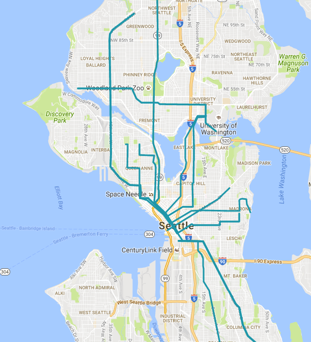
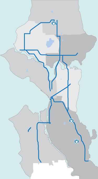
Compare the top ten corridors (by riders per mile) map to the Move Seattle’s map of the next seven RapidRide corridors that will bring Seatte’s total to ten with the current RapidRides E, D, and C.
In case there is any doubt to the top ten, below are the next ten corridors by riders per mile. All of the seven RapidRide+ corridors (plus the existing C) are in the top twenty. It seems not an issue that the RapidRide selections are bad, but that some routes seem to be getting overlooked. Beacon Avenue’s Route 36 scored very well in riders per mile and serves an area with a significant low income and transit dependent population. Queen Anne anchors two top ten corridors (in riders per mile anyway) with Queen Anne Avenue and Taylor Avenue. Those two routes both go through Downtown and First Hill before branching out in the Central District.
| Corridor | Ridership/mile | Length (miles) | Routes | Total Weekday Ridership | |
|---|---|---|---|---|---|
| 11 | Denny Way | 1200 | 6.6 | 8 | 7,700 |
| 12 | California Avenue SW | 1200 | 11.5 | C, 128 | 14,300 |
| 13 | NW 85th Street/University Way | 1100 | 6.5 | 45 | 7,200 |
| 14 | E 23rd Avenue | 1000 | 6.1 | 49 | 7,100 |
| 15 | NE 125th Street/I-5 | 1000 | 10 | 41 | 10,000 |
| 16 | Westlake Avenue/Leary Way | 900 | 12.5 | 40 | 11,400 |
| 17 | Lake City Way/SR-522 | 900 | 13 | 372, 522, 309, 312 | 13,100 |
| 18 | Delridge Way | 800 | 12 | 120 | 9,200 |
| 19 | Dexter/Stone Way/65th Street | 700 | 9.5 | 62 | 6,500 |
| 20 | Roosevelt Way | 600 | 7 | 67 | 4,400 |
Another factor to consider is how bus ridership will interplay with light rail and streetcar ridership. The Link is the ultimate transit corridor hovering around 65,000 daily riders on its 18.8-mile length for about 3,500 riders per mile. Extending the Link to Capitol Hill and to Husky Stadium was great for the city, but it did cannibalize some bus ridership and the bus restructure altered patterns further. Extending the Link to Northgate will change the ridership landscape even further. Nonetheless most transit users prefer the reliability of light rail to erratic bus routes.
If Westlake Avenue included a portion of the South Lake Union Streetcar ridership, then it’d certainly climb the list. Westlake Avenue is also hampered in securing riders per mile by how long its bus route is. The Route 40 meanders all the way to Northgate Transit Center…via 24th Ave NW. Not an arrow shot. And there’s the larger issue of how to group the bus routes together in the first place. Obviously, one could make a case for different groupings. Regardless, the top twenty routes enumerated here represent crucial corridors for Seattle transit users and ripe avenues for service upgrades.