The design for upgraded bike lanes in Fremont have been released. In 2020, the Seattle Department of Transportation (SDOT) plans to install bike lanes with partial protection in both directions of N 34th St between Fremont Ave N and Stone Way N. The partial protection comes with very modest buffering from car lanes and flexible post delineators. Earlier design concepts had considered wider bike lanes in both directions and even a cycletrack on the south side of the street that would tie into the one west of Fremont Ave N.
Project Corridor

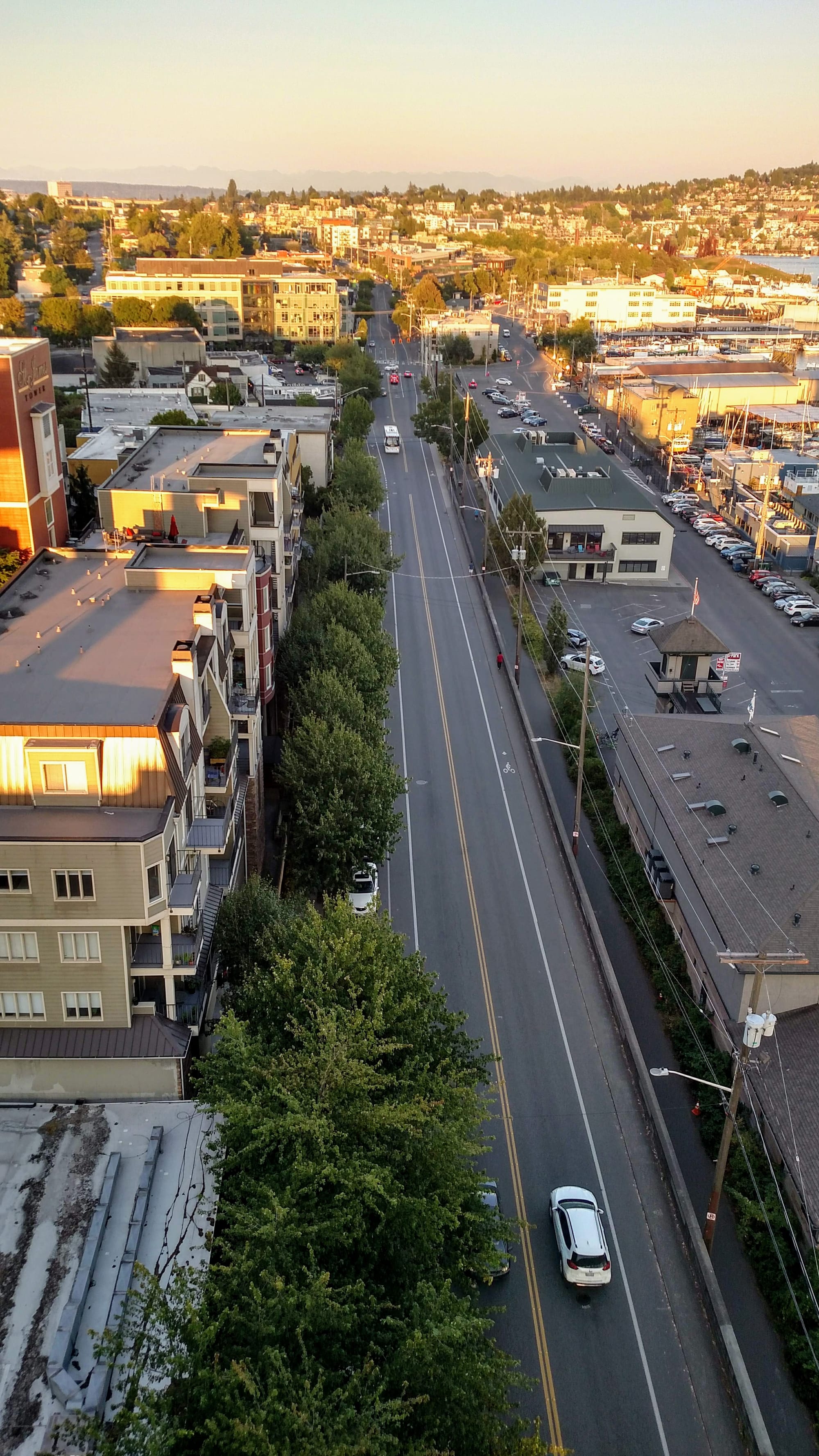
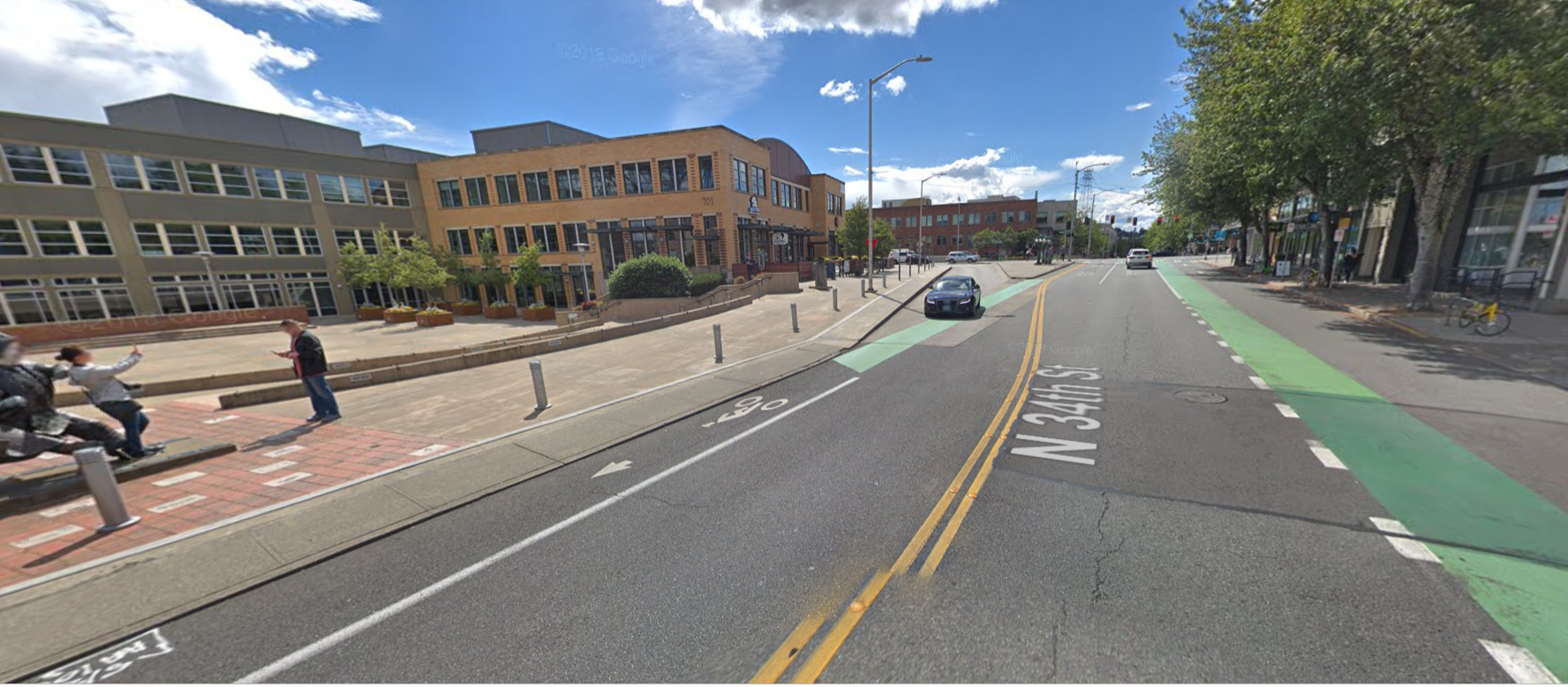
The project corridor is planned to be fairly narrow, from Fremont Ave N to Stone Way N. The street currently has a bike lane in each direction with no formal separation, but the bike lanes are marked. The bike lanes connect with existing facilities like the Burke-Gilman Trail at Stone Way N and a two-way cycletrack on the west side of N 34th St that leads to another Burke-Gilman Trail access point at Phinney Ave N.
The intersection with Fremont Ave N is a critical one because it is one block north of the Fremont Bridge and one block south of an awkward five-pronged intersection. As one of the busiest bascule bridges around, the Fremont Bridge often gets raised, creating inconsistent traffic flows and traffic bunching on nearby streets just north of it. People on bikes are forced on and off of a small sidewalk shared with people on foot along the bridge section. That can create stressful situations, especially when trying to avoid cars at certain conflict points.
Adding to the challenges are busy bus stops, which are located just north of the intersection in both directions. These stops often are associated with challenging movements for buses, particularly those turning to and from N 35th St and Fremont Pl N. And then on top all of this, there is an atypical concrete refuge island with a statue on the east side of the intersection.
At the eastern end of the corridor, the connection point to the Burke-Gilman Trail is awkward because the curb to the sidewalk and multiuse trail is so narrow. No specific space is identified for people biking and it is not clear how people biking to the westbound bike lane on N 34th St should move from the Burke-Gilman Trail.
Another issue is sidewalks along N 34th St. The south side of the street has substandard sidewalks, which are no more than four feet in width and have no planter strip. This makes it difficult for multiple people to walk side-by-side or pass each other, particularly if they require assistance with a wheelchair. Crossing the street north-south is perhaps a surprisingly common occurrence along the street since there is mostly no buildings on the south, but there is no pedestrian crossings and minimal speed controls in place, making it a very uncomfortable stretch of road to walk along.
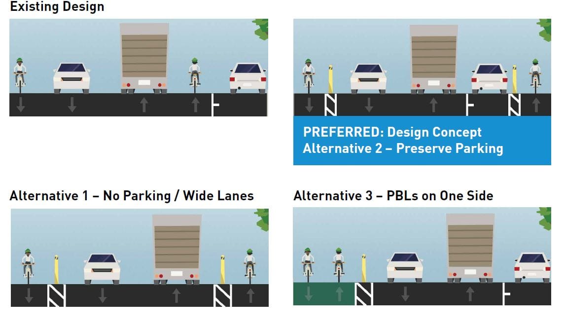
Substandard bike lanes proposed
Despite nearly half of all respondents surveyed supporting installing a two-way cycletrack on the south side of the street, SDOT says that the concept did not measure up to various criteria. One of those criteria is “traffic impact to people biking,” but SDOT’s materials do not explain what that would be. The only obvious “impact” of the two-way protected bike lane would be that westbound cyclists would cross the path of motorists using the right turn slip lane to merge onto N 34th St from the Fremont Bridge. With traffic calming this could be manageable, but SDOT may be concerned about keeping cars flowing across the bridge.
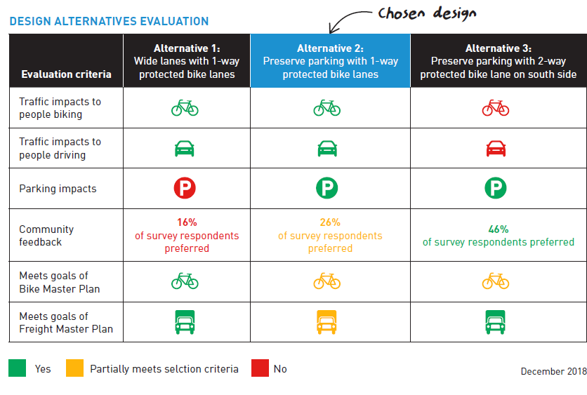
A narrow partially protected bike lane in both directions will continue to leave people biking through on N 34th St disjointed as they have to shuffle across a bike box in the westbound direction to set themselves in the right position to reach the cycletrack on the opposite side of N 34th St. This is not a challenge in the opposite direction.
What this really amounts to is that SDOT does not need to make a special light phase for people biking across the street on a cycletrack. The design also means that parking can be retained on the north side of the street, not rustling the feathers of local business owners who may believe that on-street parking is critical to business.
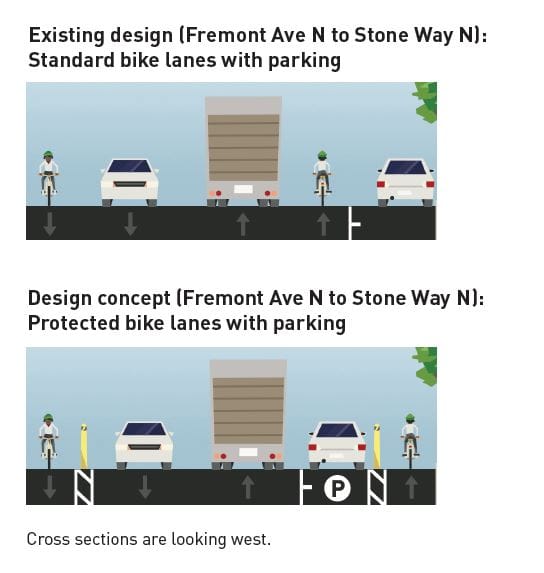
While overall design will result in a minor change for people biking on the corridor, as bike lanes are already stripped along the street, the proposed design concept introduces a serious challenge for planners to keep the bike lane on the north side consistent, as curb bulbs currently exist along the street. It seems inevitable that this will create unpleasant jockeying for people biking in the westbound direction several times and reduce partial protection.
As SDOT moves ahead with design, they will have a lot of hard choices about how to calm speeds and traffic along the corridor, shoehorn in substandard bike lane upgrades, and deal with the critical movements that people biking at the intersections with Fremont Ave N and Stone Way N need to make. The early design concepts do not shed light on how these issues might be dealt with. SDOT will also need to consider how to provide for people walking along the corridor, since that falls within the scope of the project, during the next phase of project development.
All of these issues could be greatly simplified if on-street parking were removed, but that does not appear to be the plan of action in this case.
SDOT is still offering an online survey of the proposed bike improvements.