Late Monday night, the Washington State Redistricting Commission failed to approve new maps for Congressional and legislative districts before the constitutional deadline, while holding private deliberations in apparent violation of state open meeting law. As a result of the commission’s failure to meet the deadline, the Washington Supreme Court will step in as mandated by the state constitution and draw these maps themselves.
That alone is big news. Even more surprising was the commission’s decision, nearly 24 hours after the deadline had expired, to submit their “final” maps anyway, in a bid to pressure the Washington Supreme Court to adopt their late work rather than create completely new maps that do not reflect partisan desires.
While the commission’s actions are stunning, they are also not surprising given its partisan design of two Republicans and two Democrats. The entire experience also clearly demonstrates the need for the Washington Supreme Court to start from a blank slate in drawing the new districts, and for state leaders to fundamentally reform the way redistricting is done in Washington State in the future.
What happened
After weeks of public hearings and testimony, and after an initial round of map proposals, the redistricting commission met at 7:00pm on Monday, November 15, five hours ahead of a constitutional deadline of midnight to approve new Congressional and legislative maps. Commissioners are each appointed by the four partisan legislative caucuses (House Democrats, House Republicans, Senate Democrats, and Senate Republicans).
Surprisingly, the commission immediately went into closed session, rather than engage in public discussion and deliberation.
During the meeting, Crosscut reporter Melissa Santos raised the possibility that this closed deliberation was a violation of the state’s Open Public Meetings Act (OPMA). Any action taken by a public body during a meeting that was held in violation of that act could be thrown out by courts. In fact, late on Tuesday open government advocate Arthur West filed suit in Thurston County Superior Court charging the commissioners with violations of the OPMA, seeking a $500 fine for each commissioner and invalidation of any maps they may have approved.
Despite these OPMA concerns being raised by Santos on Monday evening, the commission proceeded with their closed session, coming back every 30 minutes or so to provide brief updates on their progress.
Finally, just minutes before midnight, the commissioners met to take action and held a brief discussion. The commissioners quickly voted to adopt a Congressional and legislative map, but did so after the clock had struck midnight. Notably, they did not actually show the maps they approved, and the public was left to wonder if the commissioners had actually reached an agreement. The commissioners also voted to approve a transmittal letter after the midnight deadline. They promised to publish the maps in the morning, and hold a news conference.
But after dawn broke on Tuesday morning, it was clear no maps were forthcoming, and a 10:00am press conference was canceled. Finally, at 11:00am on Tuesday, the commission announced that in fact no agreement had been reached, no maps had been approved, and the Washington Supreme Court would indeed have to draw the maps. The Court must do so by April 30, 2022.
There the matter stood until Tuesday evening. Shortly after 9:30pm on Tuesday, the commission put out a statement claiming that the final maps had indeed been approved by the commission — but after the deadline. They then asked the Washington Supreme Court to approve their maps anyway.
These remarkable 24 hours raise serious questions about the operations of the commission, the actions of the commissioners, and suggest they went about their work without respect for the law or for the public. Because three of the four commissioners recently served in the state legislature, it is possible that what we saw was an unintentional revealing of the real methods by which the legislature operates.
What’s in the commission maps
The maps that the commission did finally publish nearly 24 hours after the deadline do not carry any legal force, and it is tempting to not even take them seriously. But they are an insight into what commissioners hoped to achieve, and if they succeed in pressuring the court, may be the starting point for the justices’ own mapping efforts. So they are worth some examination.
Their proposed Congressional maps largely maintain the status quo in geography and partisanship. Dave Wasserman of the Cook Political Report took a quick look at the maps on Tuesday evening and concluded they would maintain the current partisan split.
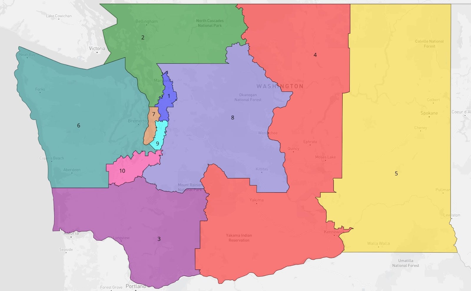
That split is six likely Democratic seats, three likely Republican seats, and the 8th Congressional District currently held by Democrat Kim Schrier as a competitive seat — yet one whose partisan makeup did not change at all, with the commission version having gone for Joe Biden in 2020 by the same six-point margin that the current version of the 8th Congressional District did.
The main geographical differences in the commission’s Congressional map appear to be in northwestern Washington. The 1st Congressional District shrinks to what looks like a corridor just east of Interstate 5 from Marysville to Kirkland. The 2nd Congressional District would grow to include all of Whatcom and Skagit counties, along with Island County and Snohomish County west of I-5. The 8th Congressional District would pick up more of rural eastern Snohomish and King counties.
Elsewhere, the 5th Congressional District would pick up some of Pasco, and the 6th Congressional District would pick up more of Tacoma.
The commission’s proposed legislative district maps appear to include many more changes, and this article will focus on a few impacts to Seattle.
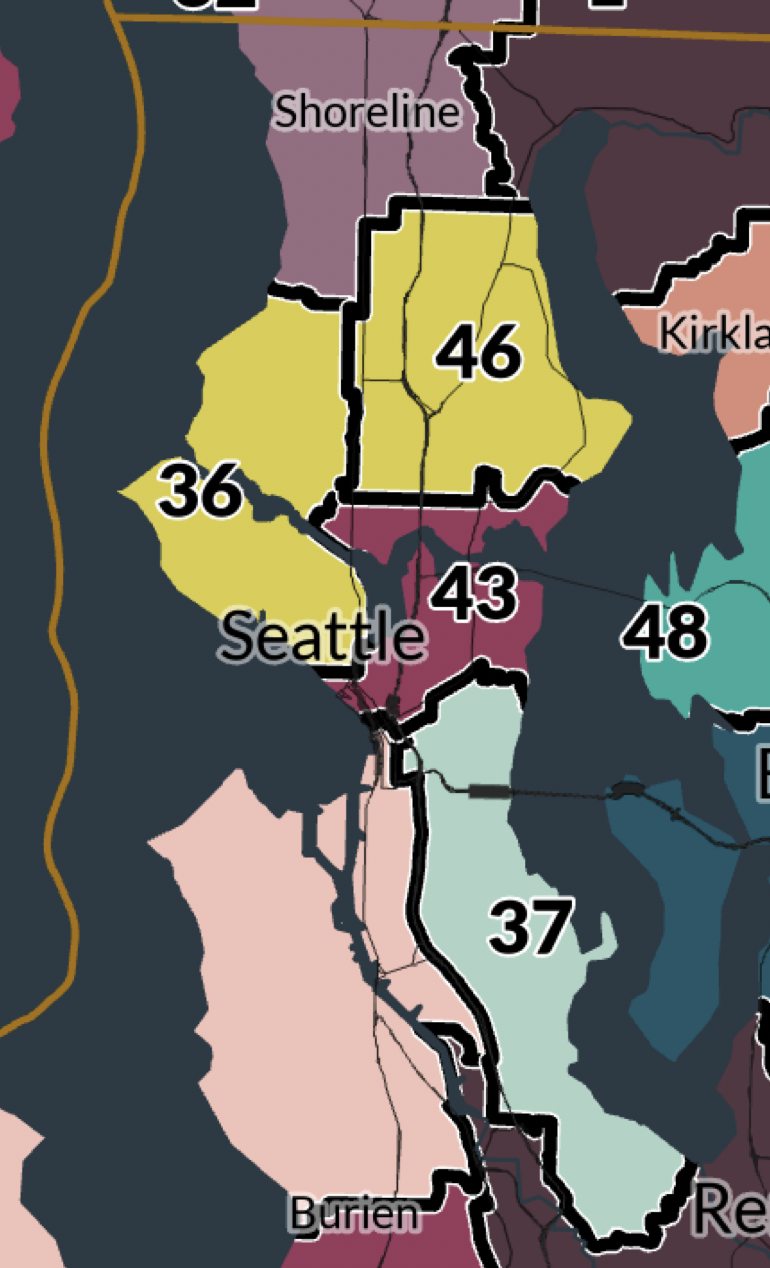
The proposed maps reject Republican plans to include Bainbridge Island in Seattle legislative districts, and reject Republican proposals to carve up the 36th Legislative District.
The maps bring the 46th Legislative District fully into Seattle, going all the way down to include Green Lake and much of the University District, which would now be split in half with the 43rd Legislative District. The 43rd would gain Belltown from the 36th and Laurelhurst from the 46th.
The 37th Legislative District would retain much of its current size, gaining all of Beacon Hill but losing Pioneer Square. The 11th Legislative District would shrink and no longer include portions of Southeast Seattle.
Beyond Seattle, further analysis will be required to see if Latino community demands in the Yakima Valley regarding representation were proposed to be met by the commission’s map. It is also unclear what these maps would do to Kent and south King County, as further analysis will be needed there as well.
Democratic concessions appear to include making the 19th Legislative District safer for far right extremist Jim Walsh, and moving the 12th Legislative District to straddle the Cascade mountains, connecting Snoqualmie and Monroe to Wenatchee. This district would move progressive Democrat Ingrid Anderson, who narrowly lost a State Senate race to incumbent Democrat Mark Mullet by 58 votes in 2020, out of the blue 5th Legislative District and into a deep red 12th Legislative District.
Of course, none of these maps produced by the commission are binding, and appear to have been produced illegally, through likely violations of the Open Public Meetings Act and definitely after the constitutional deadline. It remains to be seen what, if any, consideration they will be given by the Washington Supreme Court.
A broken system
The deeper questions raised by these events involve the future of redistricting itself in Washington State. The current commission was created by the legislature in 1983 after several decades of court-ordered redistricting (with a minor revision in 2016 creating the current language governing the process).
Despite this being the first time Washington State’s commission has failed to meet the deadline, it is actually the second time this year that a redistricting commission with equal numbers of Republicans and Democrats, without any independent tiebreakers, has failed to approve new maps. Earlier this month a similar commission deadlocked in Virginia, throwing that state’s redistricting to the Virginia Supreme Court.
This outcome should not be a surprise to anyone. Perhaps in the early 1980s, deals were still possible between Democrats and reasonable Republicans, who still held some sway in that party. Here in 2021, however, Republicans across America have made it crystal clear they do not intend to act reasonably in redistricting processes, and Washington’s Republican redistricting commissioners were no different. A system that gives Republicans veto power is a system designed to fail.
Because each political party has an equal number of votes on the commission, and because at least three votes were needed to approve maps, Republicans had leverage to demand Democrats accept some or all of their extreme gerrymanders, or risk letting the Washington Supreme Court draw maps with unpredictable results.
It is still unclear what exactly happened on Monday night in the final negotiations, since they appear to have been held illegally, behind closed doors. Even if the Republicans abandoned their extremist demands, we don’t know when, or why, or what they wanted and received in return.
What happens next
The good news is that the extreme gerrymanders proposed by Washington Republicans are off the table, and the Washington Supreme Court is unlikely to pursue them. However, it’s not at all clear what kind of maps the court will adopt instead.
The last time the courts drew Washington’s Congressional and legislative districts was in 1972. U.S. federal courts stepped in when legislators failed to reach agreement on maps by the required deadline.
In a move that may hold important precedent for us in 2021, a panel of federal judges started with a blank slate in 1972. They appointed a Special Master, University of Washington geography professor Richard C. Morrill, to draw the lines, and he started from scratch.
The court adopted Morrill’s map, despite concerns from unions and tribal nations that the districts were drawn to favor Republicans and miscounted tribal populations. The court also did not hold public hearings, which also raised objections. Morrill later drew the Seattle City Council district maps used in the successful 2013 ballot initiative creating seven council districts.
The 1983 constitutional amendment that created the current commission is silent on the process by which the Washington Supreme Court must draw these lines, only that they must do so by April 30th and otherwise follow the same rules guiding mapping as the commission had to follow. It is not clear yet whether the court will appoint a Special Master, as happened in 1972, or follow some other model.
Because the commissioners were appointed by the legislature, they were widely expected to try and protect incumbents to the extent possible. But the Washington Supreme Court is under no such pressure, and can ignore incumbency entirely, which may strike fear into the hearts of current legislators. The April 30th deadline for the court to adopt a plan comes about three weeks before the filing deadline to run for state legislature in the 2022 election.
It is likely that the 2021 commission published its “final” maps on Tuesday night in an effort to pressure the court away from drawing totally new lines. But the court does have precedent to go their own way.
Considerable work was done to mobilize members of the public to provide testimony and feedback to the commission. Despite the commission’s failures, this work may still be of value. It will likely be submitted to the Washington Supreme Court as evidence to help guide the court as it works to adopt new maps. This time, unlike in 1972, the court should ensure that public input, whether through additional hearings or through inclusion of the comments and testimony already submitted, becomes an important part of their redistricting work.
A new approach is needed
It is clear that Washington State needs major changes ahead of the next redistricting cycle in 2031. The commission could be reformed to resemble California’s redistricting commission, which is completely independent of the political parties and has a tie breaking majority of nonpartisan members. Their deliberations happen in full public view, and they work off of a single public draft map. This allows members of the public to respond to proposals and raise concerns, as is currently happening with various aspects of the proposed California maps.
If any kind of commission is still used, it should be required to publish a final map at least 72 hours before it can be voted on and approved. And the commission must be clearly and explicitly required to hold all deliberations in public in conformance with the Open Public Meetings Act.
The state could also choose to follow the lead of nearby jurisdictions like British Columbia and reduce or exclude partisanship entirely. British Columbia’s Electoral Boundaries Commission consists of a retired judge, the province’s Chief Elections Officer (a nonpartisan civil servant), and a third member recommended by both the leaders of the governing and opposition parties.
Of course, there are electoral models that eliminate redistricting entirely. Kamau Chege of the Washington Community Alliance suggested Monday night that by turning to a purely proportional representation system, there would be no need to draw new districts as there would no longer be any districts to redraw.
Legislators and voters are in for another five months of political uncertainty as we await the Washington Supreme Court’s work. Whether or not we see a radical remaking of the Congressional and legislative maps, it is clearly time for a radical remaking of redistricting to take the partisanship out and put voting rights, racial justice, and respect for open public deliberation firmly in the center.
Redistricting Maps Show Aggressive Republican Gerrymandering as Deadline Approaches