Note: This article was updated on 1/4/22 to insert the correct map for City Council District 2.
Tacoma’s affordable housing initiative, Home in Tacoma, officially passed on December 7th, and now its next phase of work can begin. This work will center on nailing down the specific details and language within the plan, and it is expected to take some time, especially since the City has committed to engaging with communities to make this our plan, not just the City’s.
Throughout the process of creating Home in Tacoma the question of equity has repeatedly come up in discussion. Do we want Tacoma to become a city that is inclusive of people from different incomes and backgrounds, or will we continue exclusionary zoning practices that favor the wealthy? Using interactive mapping technology (GIS), I analyzed how the plan’s zoning changes align with access to opportunity across each of Tacoma’s five City Council Districts. To do so, I focused on the most controversial aspect of the Home in Tacoma plan: Mid-Scale Residential Zones.
Previously for The Urbanist, I reported on how city officials reduced the amount of land dedicated to Mid-Scale zoning in the Home in Tacoma after some residents, mostly single-family homeowners, expressed concerns about how the rezones would change their neighborhoods. The share of Mid-Scale zoning went from 40% of residential land in early draft to 17.5% in the final draft. In my spatial analysis, I focused on the impact of Mid-Scale Residential zoning because it is posed to have the most impact on equity in Tacoma by bringing more new homes into neighborhoods than other zoning designations.
Mid-Scale housing is the key to ensuring Tacoma is a livable city for all, and it could also be the key to improving affordability and livability for other cities as well. Across Puget Sound (and the United States as a whole), cities are confronting rising housing costs worsened by housing scarcity. While not as ambitious as it initially set out to be, the City is taking a proactive approach to confronting these problems with Home in Tacoma. However, as the maps and data show, current plans shortchange equity by limiting Mid-Scale zoning in areas of the city with high access to opportunity.
Mid-Scale Residential Zoning in Tacoma
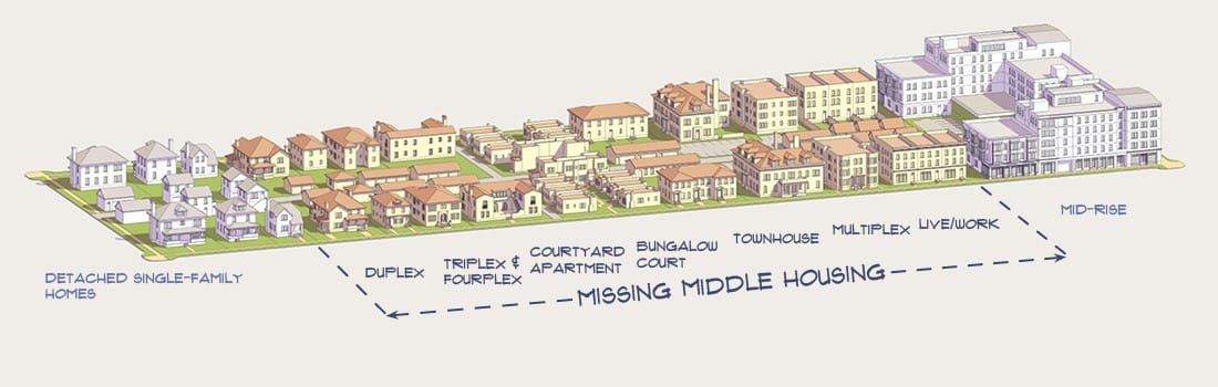
Under Home in Tacoma, Mid-Scale zones will allow for residences from duplexes up to small apartment buildings to be constructed. The apartment buildings would be no more than three stories, though four will be allowed in some cases. Duplexes and the like would occupy the same amount of space as a single family home, while allowing more people to live in the same amount of space. These housing types are commonly referred to as missing middle housing.
Cities have two options for growth: to spread out across a wide area or to use existing spaces to build vertically. Since Tacoma is surrounded by water and other cities, spreading out is not an option unless we want to eliminate all open and green spaces in the city or start building our version of Waterworld. Therefore, the only path forward is to begin to increase density by allowing slightly taller developments or denser living situations.
Mid-Scale housing has the potential to significantly grow Tacoma’s housing stock, which would hopefully ease rising house prices and rent. With the increasing presence of homeless folks and difficulty finding housing for those who can (barely) afford it. The situation is growing dire, demanding sweeping action like Home in Tacoma.
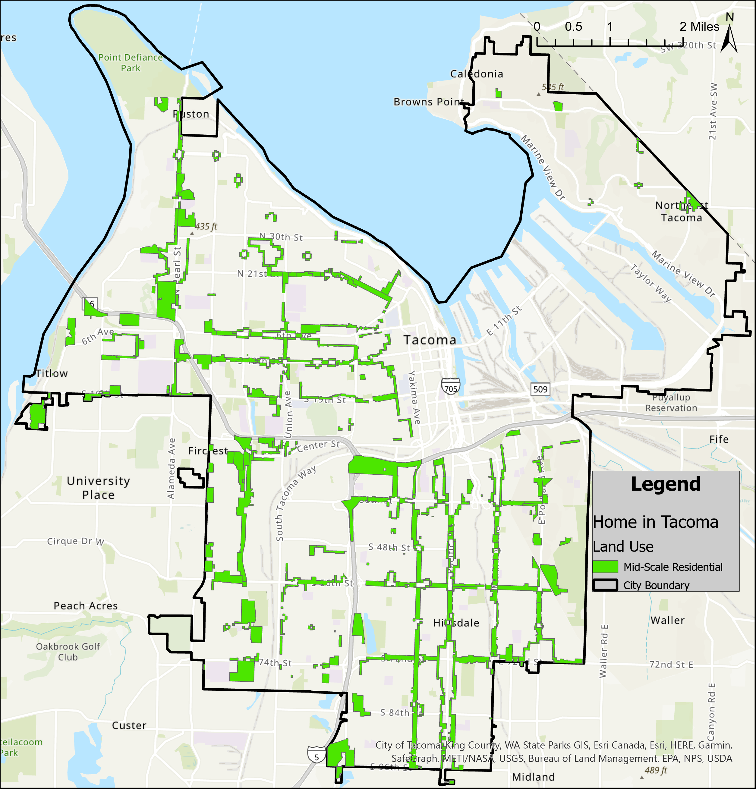
As you can see above, Mid-Scale does not appear to be unique to just one area, at least in the main portion of the city laying west and south of the Port of Tacoma. Tacoma clearly intends for the rezoning to help grow the housing stock citywide. That is a good thing and a good precedent for Tacoma to set for other cities.
If Tacoma were to concentrate (or ignore) residential development in certain areas, when most areas are suitable for more housing (and in need of it), it would be obvious discrimination. One community could choose their living situation freely, while the other is given limited options. One community gets to preserve their way of life, while the other must adapt to a new system.
Such an approach to development would be completely unacceptable. Every resident of Tacoma should be allowed to have a warm, comfortable, safe place to lay their head without having to sacrifice everything else in their life, and they should be able to live in whatever part of the city most suits their needs.
Looking at this citywide map, it is difficult to see how Mid-Rise zoning will unfold on the neighborhood scale. But before we delve into that level of detail, let’s quickly discuss Tacoma’s Equity Index, which provides important context for understanding the potential impacts of zoning changes.
Opportunities in Tacoma (for some)
In 2020, the City of Tacoma collaborated with Ohio State University’s Kirwan Institute of Race and Social Justice to develop an Equity/Opportunity Index for the City. The index breaks up the City by census tract and assigns a score based on how equitable each is. The index is composed of many socioeconomic variables, grouped into Accessibility, Livability, Education, Economy, and Environmental Health.
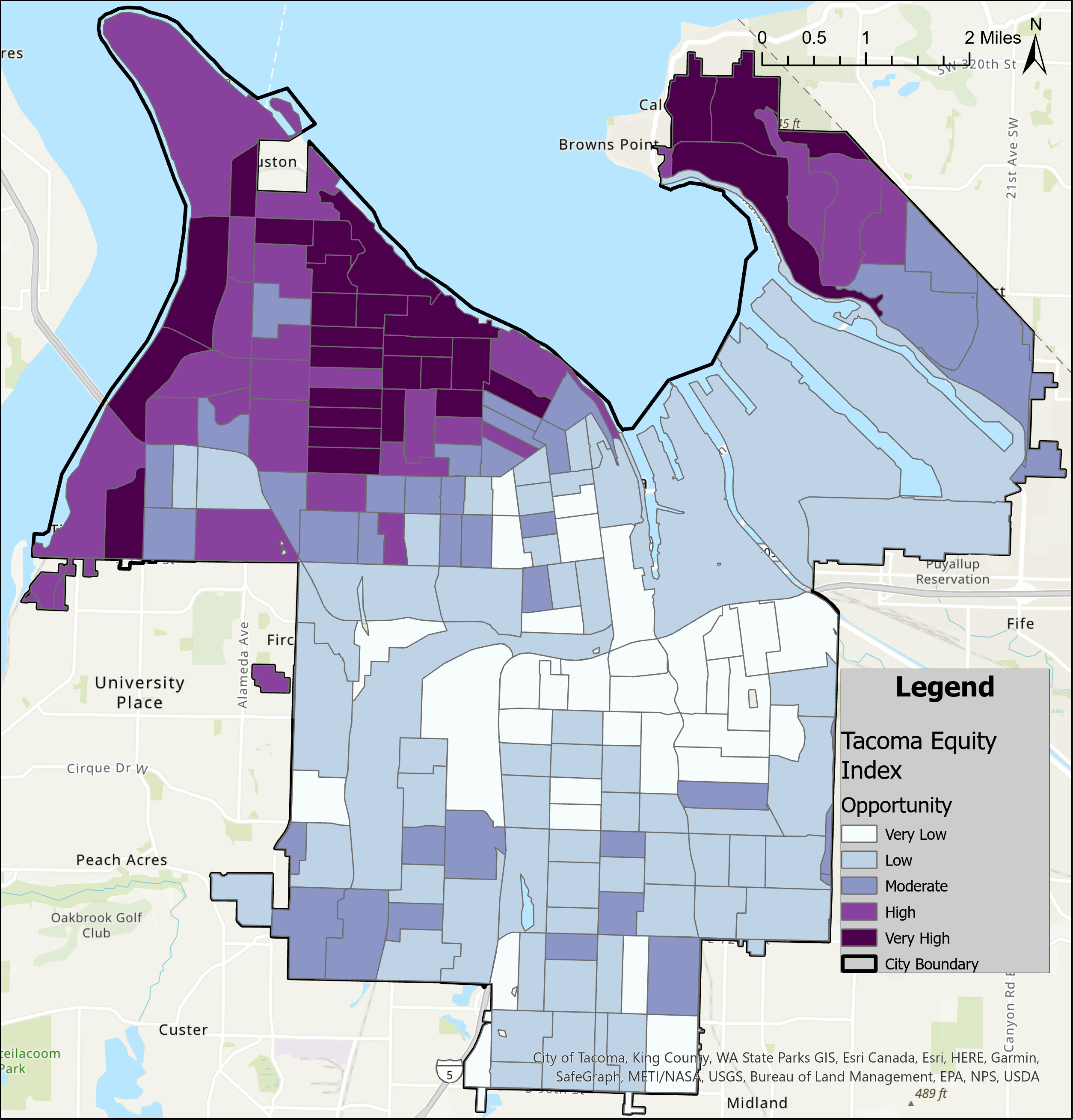
You could think of a high equity score as an area having more opportunities for all people to live, work and thrive. Low equity scores means greater segregation of social classes, lower community health, and higher rates of poverty, among other issues. For simplicity, the index will be referred to as the Opportunity index, where a higher score indicates more opportunities available to residents.
So, the Opportunity Index is a comprehensive and powerful tool to gain an insight into oppressive systems, both visible and invisible, in our City. Combining it with the Mid-Scale data could provide useful information around how these invisible structures may have influenced where the Mid-Scale zones are located.
If you live in Tacoma, look for where you live. What score does your area get? How does it compare to neighborhoods around you?
For taking a closer look, a really quick way to break up the city is by looking at City Council Districts. While not a perfect way to divide up the city (there are dozens of ways to do it!), a district analysis will allow us to view portions of the city one at a time and not be distracted by trying to look at the full picture all at once. As you will see, there are also notable discrepancies in Mid-Scale zoning across districts.
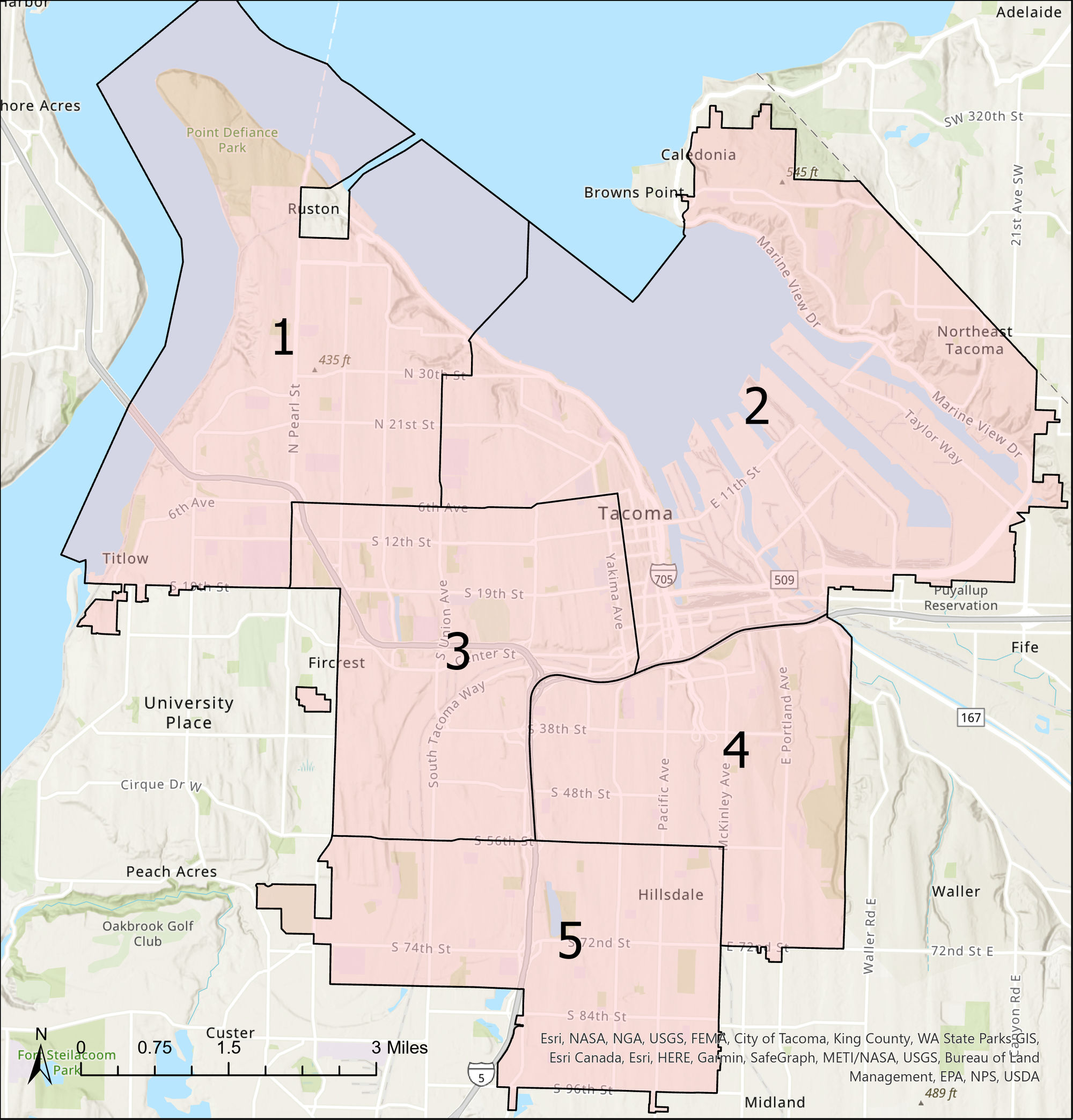
Disappointing districts
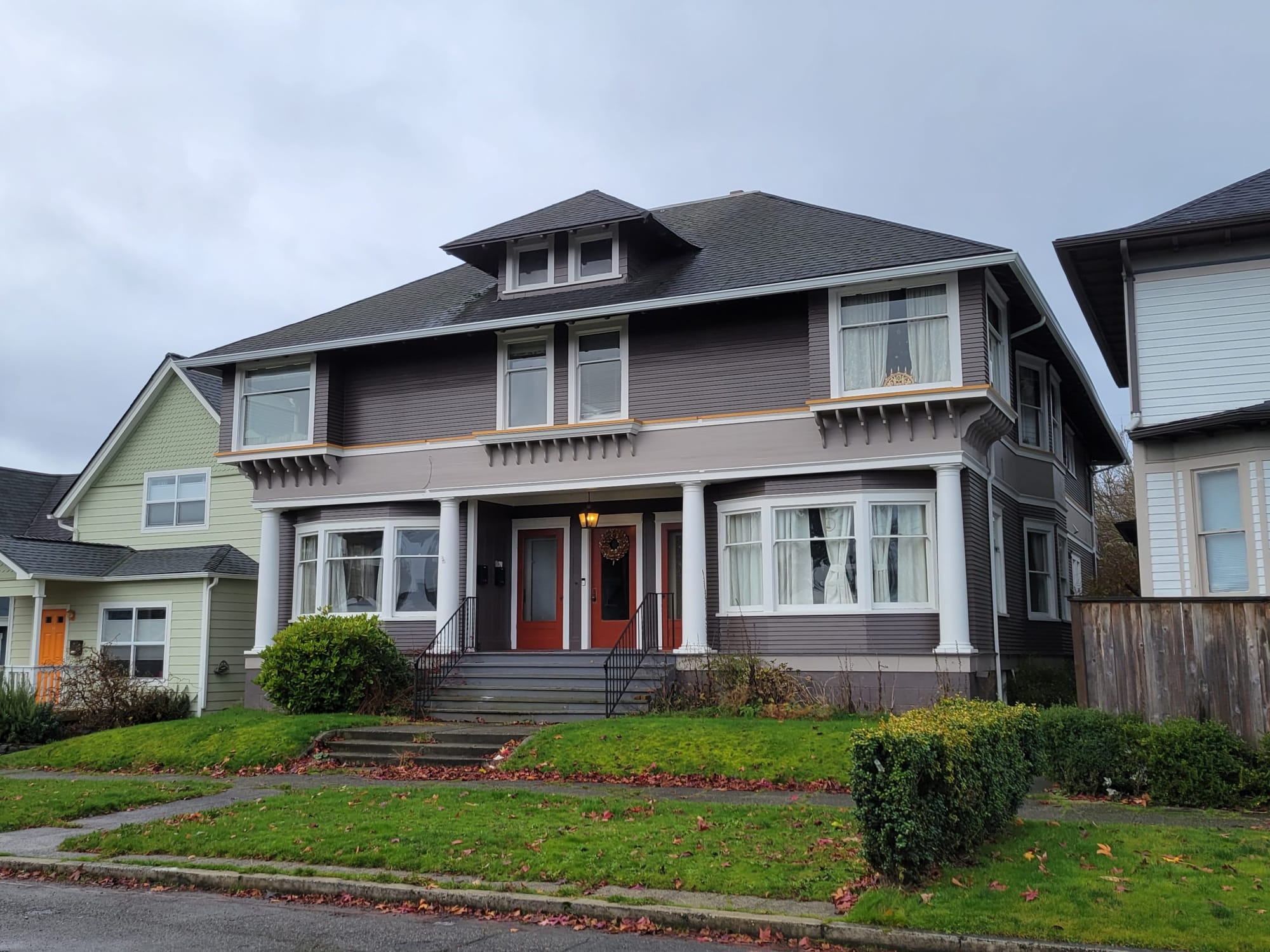
In District 1, located in the North End, we can clearly see that these census tracts possess the highest access to opportunity in the city. This isn’t surprising given that their communities are undeniably wealthier and Whiter than other areas of the city. This district is also where many of the older, larger single family homes are located in Tacoma, such as in the Historic North Slope Neighborhood. Though a number of these residences have been converted into multi-household complexes, many more remain inhabited by a single-family or small households, an inefficient use of housing. Converting or redeveloping these large, underused homes could shore up housing immensely in this high opportunity area.
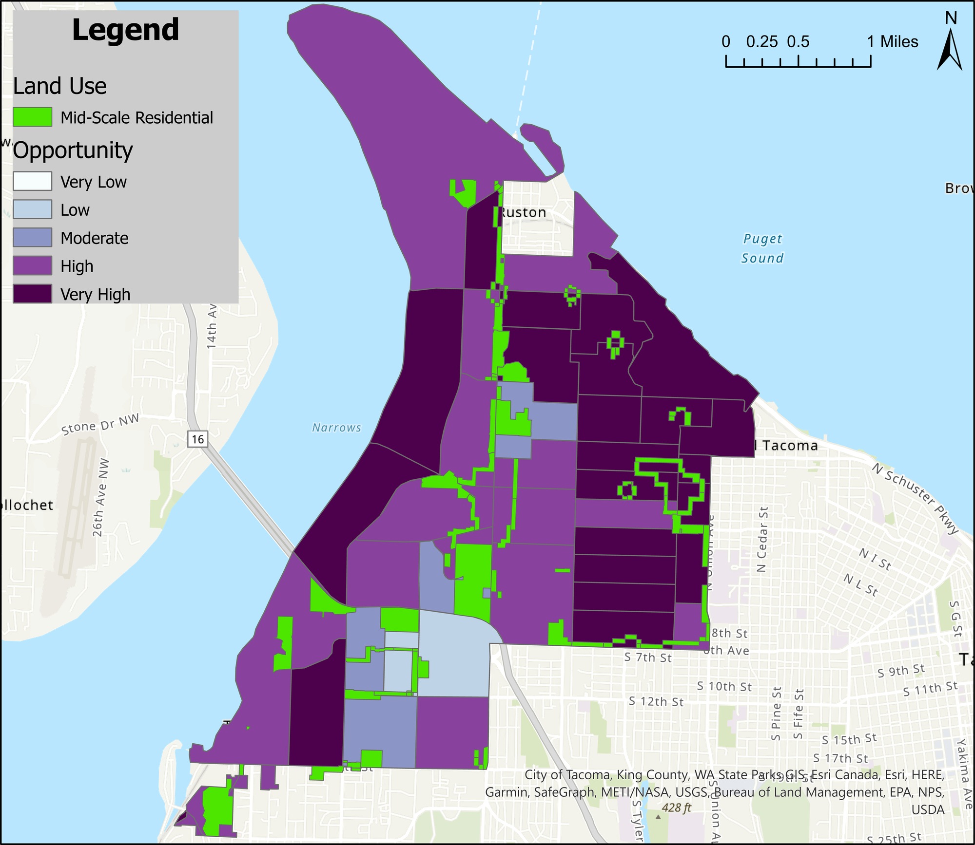
We can see Mid-Scale zoned areas exist in three main groupings in District 1. The first is along North Pearl Street from SR-16 to Point Defiance Park, the second around the Proctor District and the last near Fircrest and Titlow Beach. Looking at these, we can see the impact of the months of public comment chipping away at Home in Tacoma. The Mid-Scale areas hardly penetrate these neighborhoods. This is incredibly disappointing, especially when one remembers that the current plan’s Mid-Scale area is less than half of one of the original proposals.
So much more housing could have been created for those that need it, but the squeaky wheels prevailed in this fight.
District 2 is made up of Downtown, the Port of Tacoma and Northeast Tacoma. It is important to point out that the Port takes up around half of the district and is not zoned for residential development. Though the presence of industrial zones or environmental hazards has not stopped the racist practice of exclusionary zoning by cities in the past.
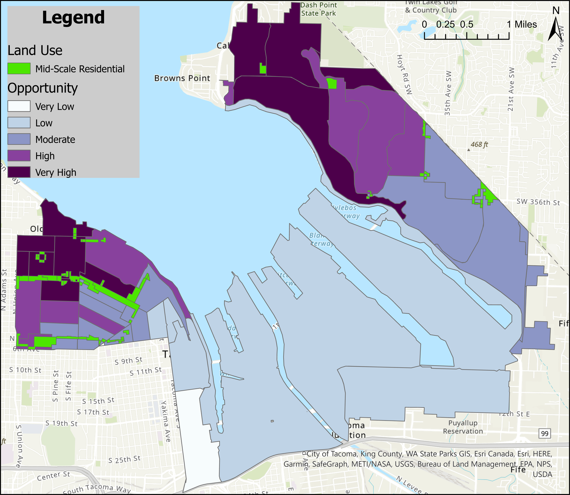
In short, zoning laws can be set up in such a way that poorer, darker-skinned communities are left living in substandard or unsafe residences while their lighter counterparts enjoy excess space and freedoms. The City of Tacoma has repeatedly stated that they aim to avoid these types of practices in implementing Home in Tacoma. So far, the map appears to line up with those intentions, but improvements could be made.
In looking at the livable areas of District 2, we see a handful of Mid-Scale areas to the Northeast near Brown’s Point and slightly more to the West near Downtown. Once again, we see Mid-Scale zoning occurring along the transit corridors but barely penetrating the residential neighborhoods, where they would make the most impact in increasing density.
Districts 1 and 2 are total disappointments for advocates of Mid-Scale housing. Density will increase in these districts, but only in certain areas and even then only to a limited degree.
Spreading the growth for everyone
District 3 includes parts of Downtown, Central Tacoma, the Tacoma Mall and part of South Tacoma Way. Immediately, we can see that this area has so much more space slated to be rezoned as Mid-Scale.
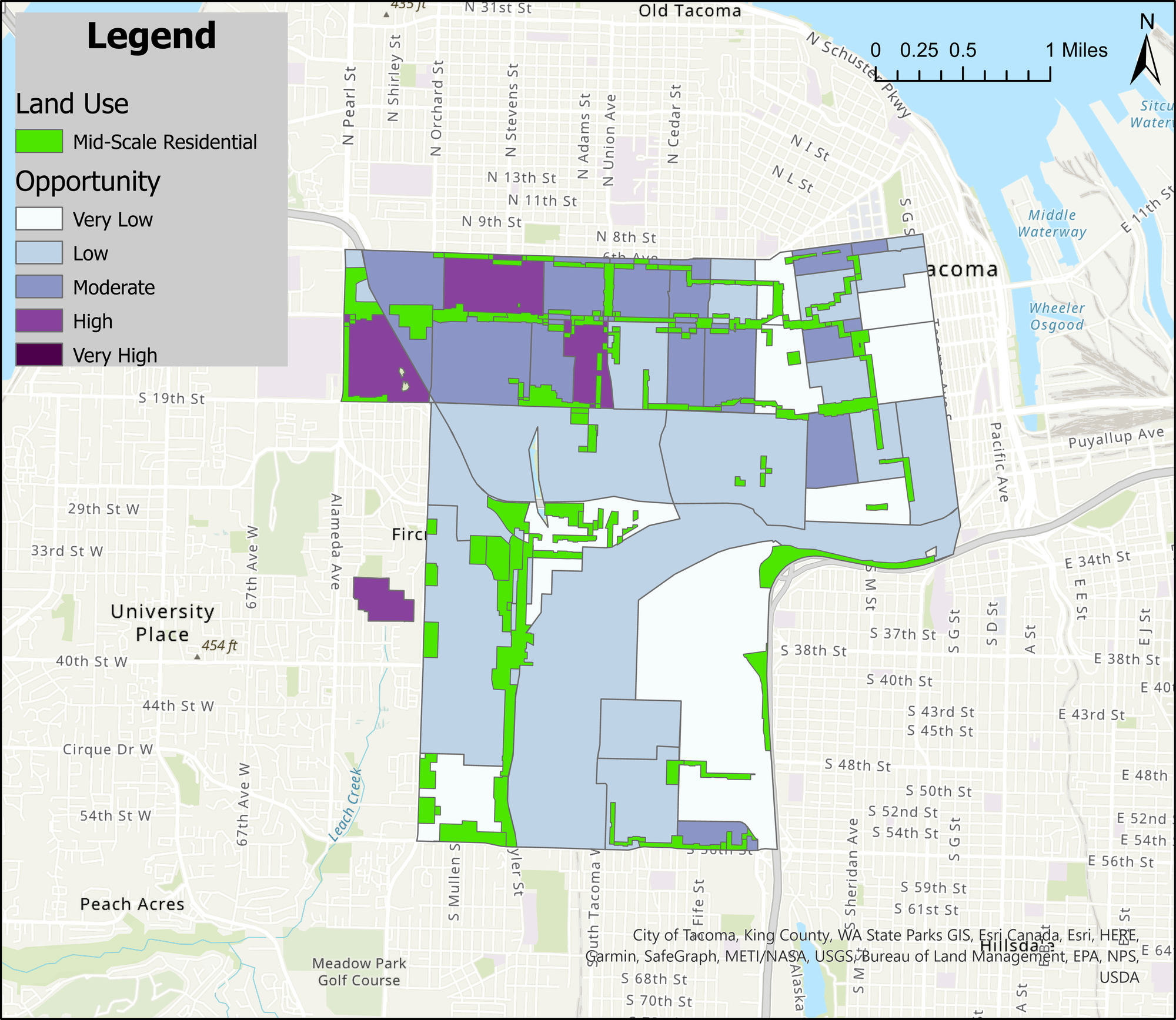
The northeast portion of this district is the historically Black Hilltop Neighborhood, which falls along the bottom edge of the western portion of District 2. They are directly next to each other but look totally different. We can see that immediately when access to opportunity lowers, the Mid-Scale zoning area increases dramatically.
This could be interpreted two ways, one way being that these areas are in greater need of affordable housing and thus more Mid-Scale zoning was allocated to serve that need. The second is that these residents have less time and fewer resources to see how Home in Tacoma affects their community and submit public comment than their more privileged northern neighbors. Both of these truths can exist simultaneously.
We can see the Mid-Scale areas criss-cross through the District 3 residential areas, intersecting one another and being larger than the areas we saw in Districts 1 and 2. This is much more pleasing to view; not only will more housing become available, it won’t be shoved off to the corner, forcing people to make more concessions when selecting their homes. With more options, people with less means can hopefully find more opportunities to grow and thrive in these districts.
Next up is District 4. Like we saw in District 3, decreased opportunity sees increased Mid-Scale areas that permeate residential neighborhoods. These Mid-Scale zones run through every neighborhood and transit corridor, spreading out the housing growth through the community so there isn’t an uneven impact.
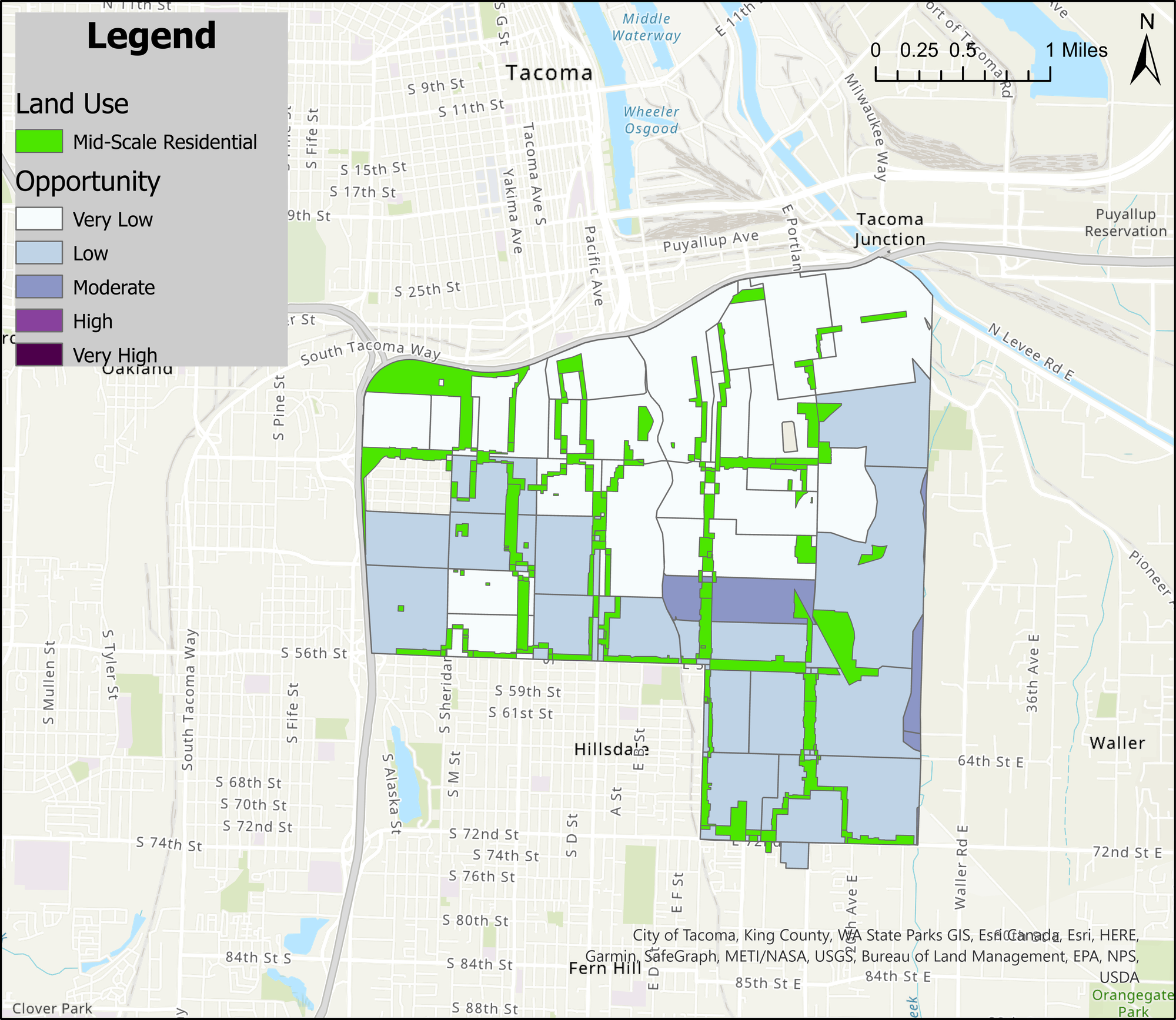
And again, this provides many more housing options for people, allowing them to choose what local amenities or jobs they would like to live near. This is what Mid-Scale zoning in high opportunity areas like District 1 should look like.
District 5 is in South Tacoma, bordering Parkland and Lakewood. Once again, Mid-Scale zoning is front and center in this district. Every neighborhood appears touched by Mid-Scale, with a couple of large zones that could serve as large housing complexes. These larger zones are present in the other districts, even 1 and 2, but they appear more often here.
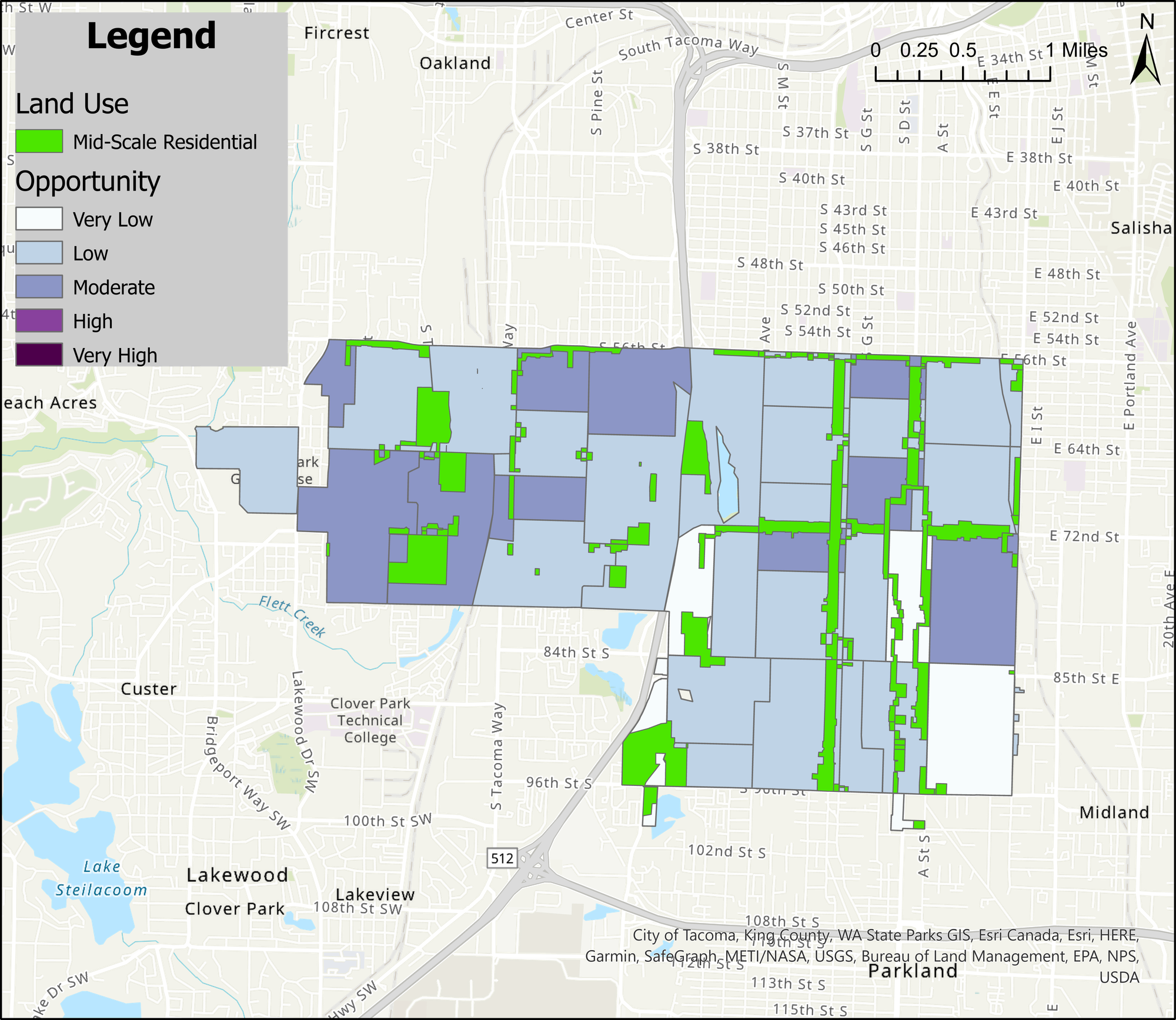
These new housing complexes, which will help build on existing dense housing in the district, will be hugely beneficial by providing homes to so many more households than a collection of duplexes and triplexes could. One caveat, however, is that South Tacoma already has a high population of people of color and these large housing complexes could serve to keep communities of color concentrated there rather than allowing them to diversify across the city.
In other words, confining the densest housing development to only a few select areas in Tacoma could serve to further segregate us. There need to be large housing complexes throughout the city, not just where people of color already live.
Bringing it all together
Below, you can see a table showing the calculated affected land area by Council District.
| District | Mid-Scale Area (sq. ft) | District Area (sq. ft) | % of Land Affected |
| 1 | 26,371,563.80 | 468,452,042.17 | 5.6% |
| 2 | 9,641,016.80 | 572,563,790.9 | 1.7% |
| 3 | 33,846,824.10 | 250,842,838 | 13.5% |
| 4 | 31,748,162.40 | 211,889,102.5 | 14.9% |
| 5 | 31,566,575.00 | 234,292,659.9 | 13.5% |
| Total | 133,174,142.10 | 1,738,040,433.41 | 7.6% |
(Credit: City of Tacoma, Kevin Le)
Keep in mind that 7.6% is a proportion of total land, not the proportion of land when we talk about the 17.5% of residential land zoned for Mid-Scale that’s in the latest version of the Home in Tacoma plan. For example, in District 2, if the Port of Tacoma were excluded, the total area would be halved and the percentage of land affected for the district would double.
But that distinction does not change the totally disproportionate treatment of communities highlighted previously. Districts 3, 4, and 5 all received near equal amounts and proportions of Mid-Scale area while Districts 1 and 2 received noticeably less, with 2 receiving less than a third of the amount of land compared to Districts 3, 4, or 5.
As stated above, Districts 3, 4 and 5 may be in greater need for affordable housing and as such may have been given more opportunity to develop it. At the same time, the more privileged residents, who likely live in Districts 1 and 2, have greater ability to share their complaints and reduce the impact of Home in Tacoma on their neighborhoods.
This is a potentially dangerous path as it could lead to greater housing segregation, directly in opposition to the goal of Home in Tacoma. The wealthy get to hold onto their high price neighborhoods, which lack Mid-Scale housing, while density is disproportionately concentrated in lower opportunity neighborhoods.
Thus, this is a call to not only rectify this disproportionate treatment across the city, but also more deeply engage Black, Indigenous, and people of color (BIPOC) populations whose voices have not yet been heard. The City’s goal of ensuring community involvement is laudable, but has been misguided in execution. As the City develops the next phase of Home in Tacoma, perhaps some squeaky wheels can be tuned out for the greater good.
As always, the City continues to take public comment for this initiative at: planning@cityoftacoma.org. Visit the project planning webpage to find more information and sign up for the project newsletter.
Thank you to the Elliot Barnett and the City of Tacoma Planning Services Department for providing data and comments that made this analysis possible.