
")
On the eve of the grand opening of Seattle’s next light rail station at Judkins Park, the Washington State Department of Transportation (WSDOT) is advancing a plan to tackle the network of highway ramps that swirl around the station’s front door at I-90 and Rainier Avenue. The department’s preferred fix would remove the northbound ramp from I-90 onto Rainier Avenue and improve safety at the other freeway ramps, although some safe streets advocates would like them to go further.
Since 2023, WSDOT has been looking at ways that the ramps around Judkins Park Station can be modified to improve safety and start to repair some of the damage from the construction of I-90 in the 1970s and 1980s. Thanks to the pairing of a state and federal grant, the department is looking at station access and will advance a concept to early level of design that can be fully funded by the legislature.
Last week, the department announced that it had selected that preferred concept after more than a year of working with a community advisory group on different alternatives.
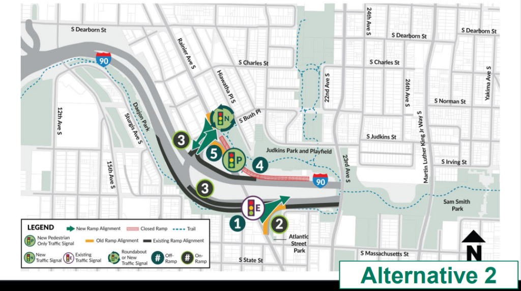
The preferred option WSDOT is now advancing would fully eliminate the northbound ramp from westbound I-90, an interchange that flies directly over a corner of Judkins Park itself. Northbound drivers would instead utilize the same ramp used by southbound drivers on the other side of Rainier, with that intersection either being modified into a full traffic signal or a roundabout. The eastbound ramp onto I-90 from the south would be squared up like a normal city intersection.
Other options looked at included squaring up all four ramps to improve visibility and reduce speeds, and removing some of the other ramps, including the one between the light rail station entrance and S Massachusetts Street. But removing other ramps, according to WSDOT’s modelling, would have caused traffic to back up I-90, and those alternatives were taken off the table.
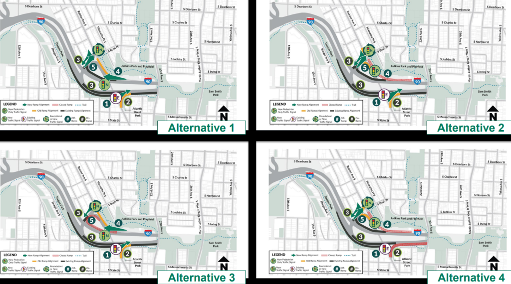
In trying to weigh the four different options, WSDOT used three different sets of criteria to balance tradeoffs, including not just parameters set by the state project team, but also parameters set by the community advisory group — one prioritizing active transportation in the area, and one “balancing” the needs of different modes travelling through the corridor.
“Alternative 2, by far, had the best value, and it wasn’t even close, in any of the three weighting [criteria], it really was head and shoulders above it,” WSDOT’s April Delchamps told The Urbanist.
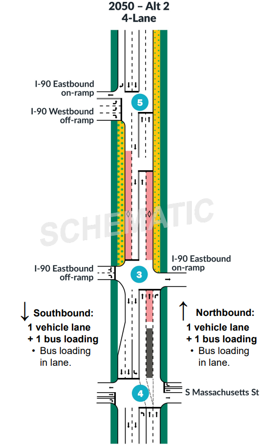
Rainier Avenue presents its own issues. A key input into how much traffic ends up on the I-90 ramps is the number of traffic lanes on Rainier, something that is ultimately controlled by the City of Seattle. To model the future needs of the I-90 ramps, the state needed to make assumptions around how much traffic volumes would change into the future as the city grows, but multimodal travel options increase.
Different sensitivity tests were run on those assumptions, but ultimately WSDOT was able to affirm that Rainier Avenue functioned well with just one general purpose lane continuing through the interchange in each direction, along with a dedicated bus lane. That represents a 50% decrease compared to the current configuration.
“This interchange is really uniquely placed in our system. I can’t really point to another interchange in the Puget Sound that is this unique [or] that is comparable. Seattle is growing, and that population is increasing, and there are a lot of assumptions around people making more trips than ever. But there really is a key difference, as you look to the future and look at the modeling and the traffic volumes that were that were given by the [Seattle] Comprehensive Plan, is that not everyone is going to be driving a car,” Delchamps said.
She noted that even though the range of assumptions about traffic growth were broad, they all ultimately pointed in the same direction.
“The interesting thing in this case is the roadway looks pretty much similar on the channelization. That sensitivity test shows that both, it’s not overbuilding, but it would still function in the opening year. So, the solution is the same,” Delchamps said.
While the removal of the northbound ramp and reducing the number of lanes on Rainier would be a big win, transportation advocates aren’t necessarily ready to stop there. Anna Zivarts, a member of the I-90 Judkins Park advisory group and the founder of the Nondrivers Alliance, has pushed WSDOT and SDOT to dream bigger and take bigger steps to improve safety and curb pollution, including in a recent pair of Urbanist op-eds.
“I really wish, and continue to want to push for us to model what would it be like to actually fully close the ramps there,” Zivarts told The Urbanist. “I think as a city, we need to be reducing car capacity on our highways and all of our urban highways — both state and federal and the ones that are operated by the city. And the only way to do that is to really reduce the amount of space for vehicles and that’s the big picture.”
“It is a step in the right direction. We’re looking at this intersection redesign from a crash prevention perspective, and also trying to maintain vehicle throughput,” Zivarts said. “They’re not looking at any of the other public health implications of having all the vehicle throughput through this area. We’re not looking at noise, we’re not looking at air [and] particle pollution, and those just aren’t being factored into any of the analysis and that that feels like a huge gap to me.”
Even just achieving the slimdown that WSDOT wants to see will remain a heavy lift, with a construction timeline still up-in-the-air. Much will depend on the state legislature’s willingness to fund restorative infrastructure like this. The federal Reconnecting Communities Pilot (RCP) Grant Program, funded by the 2021 Infrastructure Investment and Jobs Act, would have provided a clear pathway to funding these changes, but those dollars were pulled back in 2025 by a Republican-led Congress.
“Now that we’re at the place where we have a preferred alternative, we can start digging into what the stormwater needs to ensure the ramps are not contributing to something like that. And once we can get through a little bit of that design — and we’re funded for that piece — we can start having a better sense of exactly how much we need for construction, and we can seek funding for that,” Delchamps said. “I wish I had a year that I could give, because I think there’s just so much swirl around funding, both at the state and the federal level, that’s hard to assume.”
Given that uncertainty, Zivarts wants the state to take an opportunity to think about being even more bold.
“We’re not talking about this getting fixed next year or the next two years,” Zivarts said. “This is really looking at the future of this area and what we want for it. I think we should be thinking a little bigger and dreaming. We’re having this incredible transit investment right there, it should be a wonderful place to live and work and go to school.”
Ryan Packer has been writing for The Urbanist since 2015, and currently reports full-time as Contributing Editor. Their beats are transportation, land use, public space, traffic safety, and obscure community meetings. Packer has also reported for other regional outlets including BikePortland, Seattle Met, and PubliCola. They live in the Capitol Hill neighborhood of Seattle.