Back in October, the Seattle City Council quietly approved a suite of changes to the city’s Comprehensive Plan. Four separate amendment proposals were placed before the Council, including: Periodic Update Amendments and 2014-2015 Annual Amendments (combined), Affordable Housing Policies, and Amendments to the University Community Urban Center. In this piece, I’ll go in-depth on the fourth Comprehensive Plan amendment, which is the result of a multi-year neighborhood-level planning update. But first, let me recap the first three amendments in brief (see the original report on these).
The Periodic Update Amendments were initiated by City staff to enhance the existing Comprehensive Plan in a few targeted areas: revising out-of-date policies, updating inventories in appendices, strengthening relationships to current plans (e.g., the Bicycle Master Plan and Right-of-Way Improvement Manual), and amending language and data for growth projections. The 2014-2015 Annual Amendments involved three subarea plan updates with a mix of text and Future Land Use Map (FLUM) amendments; it’s the latter that is of the most significance. Five amendments were made to the FLUM in the 23rd & Union-Jackson Residential Urban Village, Morgan Junction Residential Urban Village, and Lake City Urban Hub Village. The Affordable Housing Policies were proposed by City staff to strength affordable housing objectives and implementation tools. For instance, adopting language to enable the City to consider mandatory and incentive-based affordable housing strategies as well as establishing a commercial linkage fee. All three sets of amendments were adopted unanimously by the City Council.
Neighborhood Planning Update
The University District has been engaged in a multi-year process to update its neighborhood plan as part of the University District Urban Design Framework. Led by Dave LaClergue, an Area Planning Manager for the University District, the City has reached out to hundreds of residents, employees, and business owners to discuss the neighborhood’s needs and future. The neighborhood planning update was partially spurred on as a response to light rail coming to the University District, but the City also elected to engage in a process to accommodate substantial growth over the next plan period to meet demand for new housing, office, and business opportunities. The overall process has moved from public outreach and conceptual planning to a formal legislative process.
The first part of the legislative process resulted in the adoption of policy revisions to the neighborhood plan and local Future Land Use Map (FLUM). Both elements are important changes, but it’s the latter that largely drives zoning and development regulations within the neighborhood. Changes to the FLUM have set the stage for complimentary changes to zoning and development regulation. The City Council is slated to take up the second part of the legislative process in early 2016. The Department of Planning and Development (DPD) is recommending major zoning changes throughout the neighborhood. Unique development regulations will likely be paired with the final rezone package.
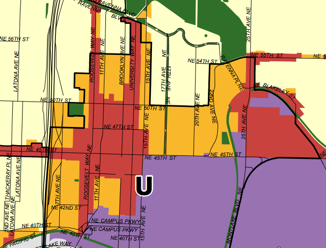
Ten changes in total were proposed to the Future Land Use Map within the University Community Urban Center. Two of changes involved removing certain residential areas from the Urban Center overlay. Another two changes involved adding areas to the Urban Center overlay. Those changes, on balance, are best viewed as a swap. Six further changes targeted actual modifications in land use designations: four of those were areas redesignated from Multi-Family Residential to Commercial / Mixed Use, one from Single Family Residential to Multi-Family Residential, and another from Single Family Residential to Commercial / Mixed Use.
These FLUM changes are highly important because they will determine whether future zoning changes will be allowed. This is a key planning concept to understand: zoning implements the Comprehensive Plan and is therefore intimately tied to FLUM designations. A property designated as Commercial / Mixed Use could not be rezoned from Neighborhood Commercial-65 (NC-65) to Single Family-5000 (SF5000) because SF5000 is not an implementing zone of the Commercial / Mixed Use land use designation. Likewise, a property zoned Midrise Residential (MR) with a Multi-Family Residential land use designation could not be rezoned to Seattle Mixed (SM).
Near Cowen Park
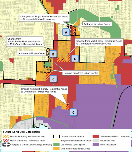
In the north end of the University District near Cowen Park, the City considered a mix of FLUM changes at the request of property owners and residents. Those proposed changes included the addition of land to the University Community Urban Center and the redesignation of individual properties from Single Family Residential and Multi-Family Residential to Commercial / Mixed Use.
The impetus for those changes largely stemmed from a desire by property owners to do more with their property, or even to legally redevelop their sites as-is, which is almost entirely prohibited under existing zoning. Uses on the properties at issue were legally established prior to revised zoning that rendered them as nonconforming.
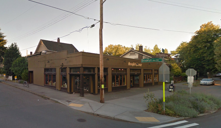
Property owners urged the City to look at specific locations along NE Ravenna Blvd and University Way NE.
The first of these is the Cowen Park Grocery (1217 NE Ravenna Blvd), which serves as a one-story mixed-use building. Under the City’s proposal, the property went from Single Family Residential to Commercial/Mixed Use with an Urban Center overlay designation.
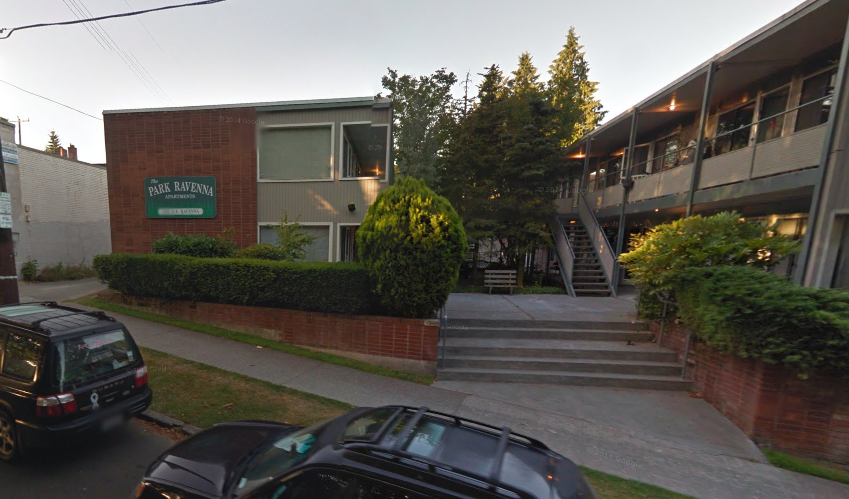
The second of these is The Park Ravenna Apartments (1305 NE Ravenna Blvd), which is a two-story apartment complex. Under the FLUM changes, the site also went from Single Family Residential to Commercial/Mixed Use with an Urban Center overlay designation.
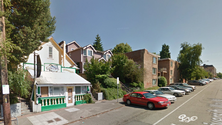
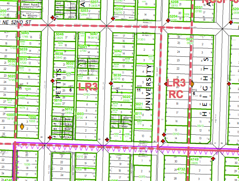
And the third of these is the east block of University Way NE, stretching from NE Ravenna Blvd to NE 56th St. That block consists of a mix of commercial and multi-family residential uses, yet the properties are zoned as LR3, a medium density residential zone. The properties were included in the Urban Center overlay so as to allow a future rezone for mixed-use, mid-rise development.
Near The University Playfield
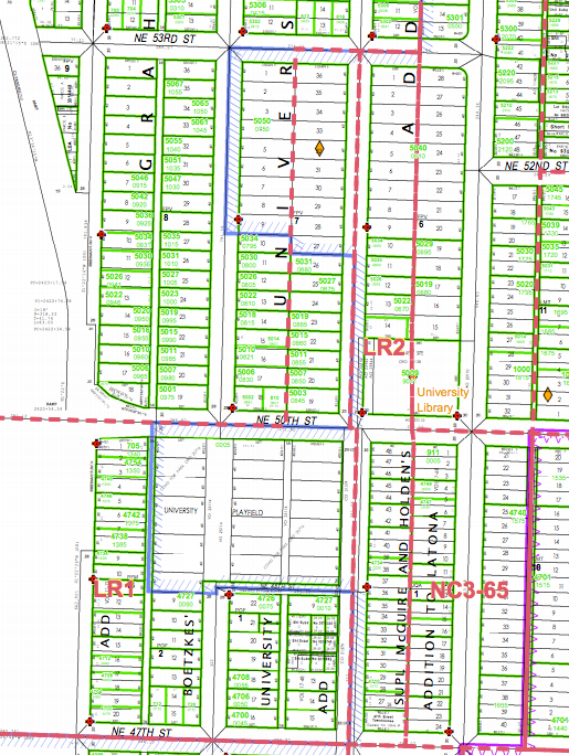
A suite of changes were made near the University Playfield, which came from separate requests by the Roosevelt Neighbors Alliance (RNA) and Blessed Sacrament Church. In sum, the adopted changes included the removal of two areas from the Urban Center overlay, addition of one area to the Urban Center overlay, and redesignation of one parcel from Single Family Residential to Muli-Family Residential.
Blessed Sacrament Church specifically pushed for the latter two changes to allow further enhancements to the parish property. Meanwhile, the RNA has feared that increasing change in the neighborhood could mean redevelopment of residential properties near the playfield, which led to their request to remove dozens of properties from the Urban Center.
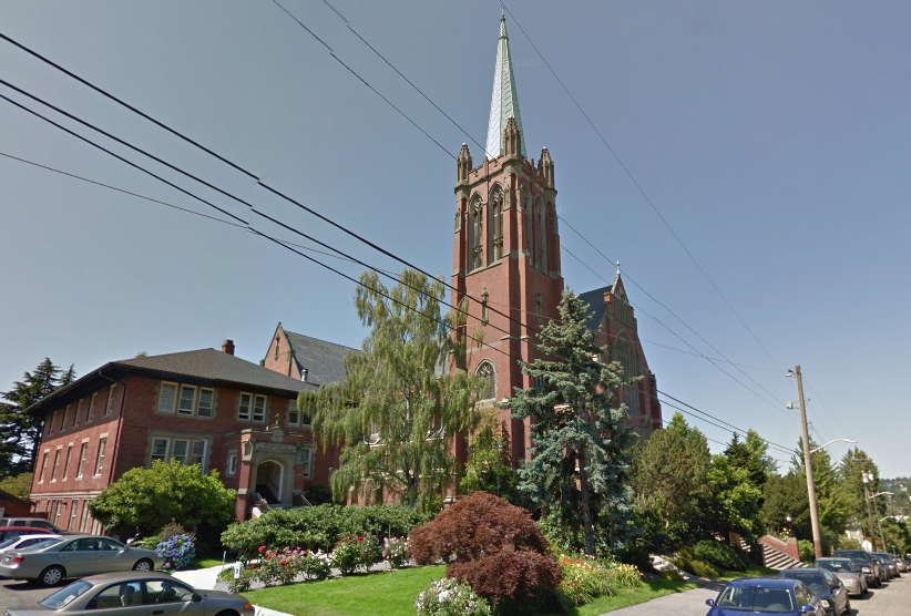
Blessed Sacrament Property
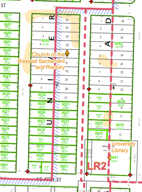
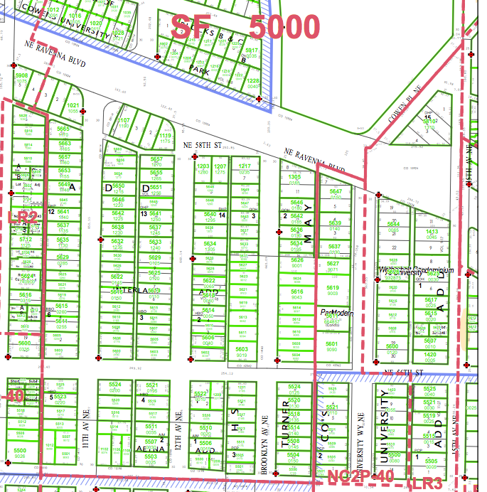
The Blessed Sacrament property is currently split zoned. A bit more than half of the site is zoned as Lowrise 1 (LR1), a medium density residential zoning type, while the other half is zoned as SF5000, a low density residential zoning type. Prior to the comprehensive plan land use map amendments, the property was also split between Multi-Family Residential with an Urban Center designation and Single Family Residential.
The parish community set out to change the future land use map designations in hopes of a subsequent rezone on the SF5000 portion of the property. The primary impetus for these changes comes from a desire to enhance the historic church property for parishioners and clergy. Under today’s development regulations for the SF5000 zone, many of the improvements envisioned would not be permitted. The parish community wants to build new accessible ramps, a below ground parking facility, and an expanded rectory for the Dominican priory.
The FLUM changes are a first step to Blessed Sacrament’s goals, but zoning changes to LR1 will still be necessary. The parish community has worked with the surrounding neighborhood on this issue, which generally supports their renovation and zoning efforts.
Roosevelt Neighbors Alliance
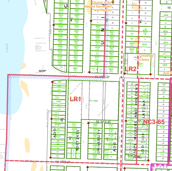
About 46 residential properties near the University Playfield are designated as Multi-Family Residential on the FLUM and zoned as LR1. Prior to changes to the FLUM, the properties had also been designated as Urban Center. Residents in the area have watched successive waves of redevelopment take hold throughout the University District, often with larger footprints and scale than the modest one- to three-story homes on the blocks west of 8th Ave NE. The RNA decided that changes to the FLUM should be made in order to discourage and eventually prevent new development in the area that is not in keeping with the prevailing land use pattern.
The RNA was partially successful in their request by removing the Urban Center designation on residential properties west of 8th Ave NE, north of NE 47th St, and south of Blessed Sacrament Church. But the Multi-Family Residential designation was not repealed from the FLUM meaning that properties will remain with their current zoning as LR1. In fact, it’s possible that higher density implementing zones of the Multi-Family Residential designation could be requested in the future. Regardless, the RNA had initially made larger overtures for FLUM changes that could have included complimentary downzones as part of an areawide “carve out” of the Urban Center. DPD rejected that proposal though in their review of the request, and in a report to the City Council, DPD staff explained the rationale for the final set of proposed changes:
DPD is not recommending zoning changes to the “carve out” area, whether or not the urban center boundary moves. RNA neighbors are aware of this, but they view the boundary adjustment as a longer term commitment from the City to direct growth to the area closer to the light rail station.
The “carve out” area is just outside the 10-minute walkshed of the light rail station, and includes affordable rental housing in free-standing single-family structures. Under existing zoning, these homes will likely redevelop to townhouses over time. Changing the urban center boundary does not eliminate development pressure, but it could prevent development pressure from increasing. Note that the RNA’s original amendment request carved out a larger area, including some LR2 on the blocks abutting Roosevelt. DPD recommends drawing the new boundary as shown here, because the Roosevelt blocks provide a valuable transition from high density growth on Roosevelt to the west.
Near University Heights, Trader Joe’s, and UW’s West Campus
Several blocks closer in to the neighborhood core received FLUM changes from Multi-Family Residential to Commercial/Mixed Use in order to allow future rezones on the properties, as envisioned by the University District Urban Design Framework. A variety of options are on the table, including rezones to Neighborhood Commercial, Seattle Mixed, and other higher-density zoning typologies. The blocks that were redesignated generally posses commercial or medium density residential uses, although a few sites include single-family homes.
University Heights
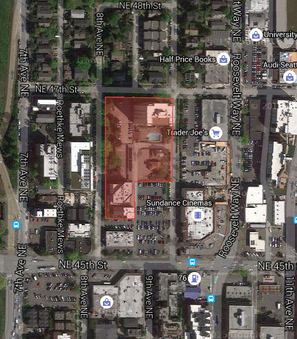
A couple dozen properties near University Heights were redesignated on the FLUM. As should be obvious from the map below, the properties tend toward commercial uses, multi-family residential, and public facilities. Three homes on NE 50th St ended up as part of the FLUM changes. Some properties are clear candidates for redevelopment or infill, but there is new construction along NE 50th St that likely will remain for some time. The University Heights Center is also off of the table for redevelopment.
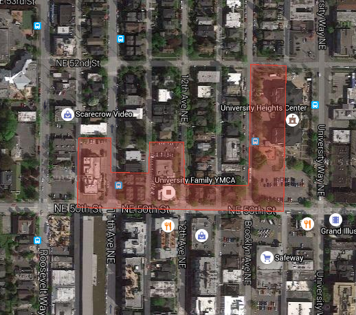
With redesignation from Multi-Family Residential to Commercial/Mixed Use, these blocks will eventually see denser zoning than the current Lowrise 3 (LR3) zone.
Block Near Trader Joe’s
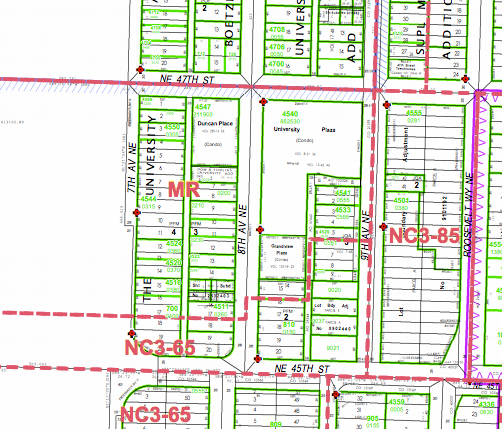
The block west of Trader Joe’s is highly mixed with an early example of residential construction in the neighborhood, surface parking, remaining single-family homes, and medium density residential. Surface parking lots predominate the southern portion of the block, in addition to a commercial building.
The properties subject to the FLUM changes are all currently zoned as MR, a medium density residential zone. It’s conceivable that future zoning changes will be closer to the scale and flexibility of adjacent NC zoning.
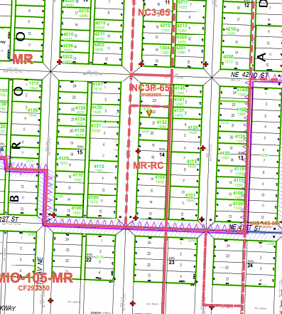
Near UW’s West Campus
The Brooklyn Ave NE block subject to the FLUM changes is a surprisingly varied street. On the north end, a church known as the Vineyard Fellowship Church contains numerous restaurants in its basement. A building at the south end of the block is truly mixed-use with ground floor retail and residential units above. In between these block anchors is a multi-family building and three single-family homes (with a pending multi-family development application).
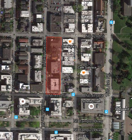
Zoning on the block essentially mimics the present land use pattern with NC and MR-RC zoning, which allow a mix of uses and densities.
Text Amendments to Neighborhood Policies
In addition to FLUM changes, DPD recommended a couple dozen revisions to the neighborhood policies in the Comprehensive Plan. Recognizing changing circumstances and achievement of past goals, DPD both added and deleted content. Changes were particularly focused on enabling greater development capacity, clearer direction for public open space, economic vitality, and mobility connections.
For instance, UC-P2 was significantly revised to more broadly support larger scale development in proximity the future University District Station.
UC-P2 ((Encourage high-quality development, up to 65 feet, or about five stories, south of NE 43rd Street, and from just east of Brooklyn to the west)), ((to enhance this residential)) area with excellent proximity to the University and to the ((LRT)) stations.
Coming off an extensive neighborhood discussion on public open space, DPD recommended dramatic changes to those policies. One way was by setting new goals to make public open space successful.
UC-P((19)) Encourage the establishment of a local open space fund that can be used to purchase and improve small parcels when the opportunity arises.
It also involved replacing policy wholesale.
((UC-P20 Place highest emphasis on open space and recreation facilities projects that will benefit the greatest number of people in areas that are least well served.))
UC-P((24)) ((In the Northern Tier (the low rise multi-family residential areas above NE 45th Street between 22nd Avenue NE and 15th Avenue NE and north of NE 50th Street and west of Brooklyn Avenue NE), seek to establish and enhance a central open space and community facility as part of the NE 50th Street Community Services Spine. (See policy UCUC 17 above).))
Policies to provide vibrancy in the commercial retail core were also urged.
UC-P((25)) In University Way-15th Avenue NE corridor between NE 55th Street and NE 41st Street, encourage the provision of more street-oriented public space through both public and private investment.
The Council voted 7 to 2 in favor of the ordinance. Councilmembers Nick Licata and Tom Rasmussen voted against the bill. Licata’s vote wasn’t a surprise given his strong opposition in committee. The adopted Comprehensive Plan changes will set the stage for a future neighborhood-wide rezone process, which will also involve new development regulations that supplement commensurate rezones.
Full Disclosure: While the author is a member of the Blessed Sacrament Church parish community, he had no involvement in the church’s FLUM proposal.