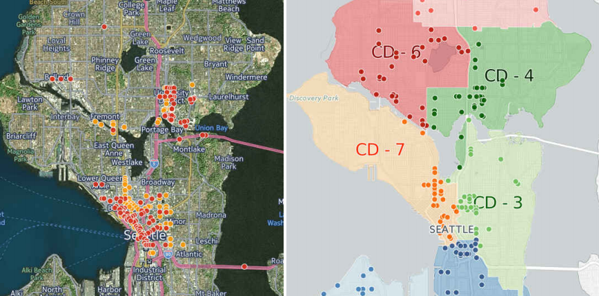
Earlier this month at the Seattle Bicycle Advisory Board, two employees of the Seattle Department of Transportation (SDOT), Monica DeWald and Chris Svolopoulos, presented the top-level of an intense study into the locations of pedestrian and bicycle collisions in Seattle. SDOT is analyzing collision data on a scale that it has not done prior to now, with the hope that the data obtained can inform key network planning and improvement projects. The team at SDOT looked at collision data over the years from 2007 to 2014 and will be releasing the full data set in the coming months.
The question is the degree to which SDOT will see the forest for the trees in terms of a systemic approach to intersection design with regard to furthering Vision Zero goals. Will spot improvements be the extent of the application of collision data, or will the findings be used more broadly to further all intersection improvements?
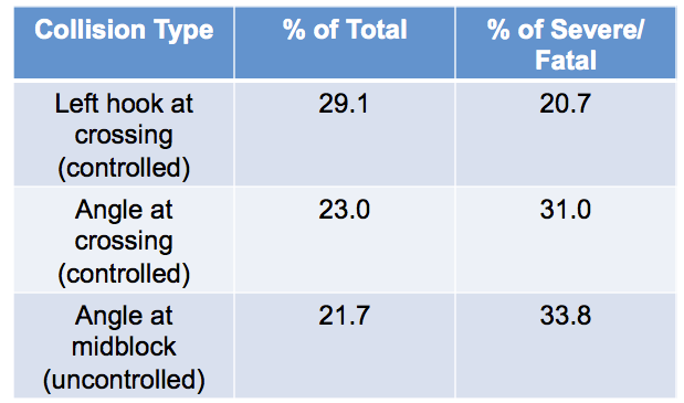
The pedestrian collision data showed that close to a third of pedestrian collisions were left hook collisions at controlled intersections, but the top type of serious and fatal collisions was one occurring at a mid-block crossing, likely because drivers are traveling at a higher speed and do not expect someone to be crossing. In other words, most pedestrian collisions are likely not “jaywalking”-related but many serious and fatal ones may be.
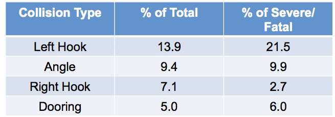
Bicycle collisions were more broadly dispersed, but more than a fifth of serious and fatal collisions also involved left hooks.
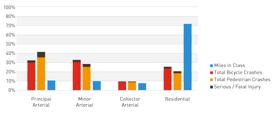
Other findings showed a predictable lopsidedness in terms of the type of road that collisions occur on, compared with their overall prevalence in the city’s streetscape. Pedestrians and people on bikes want to use primary arterials.
During the meeting, Chris Svolopoulos discussed the current limitations of the data being used: things like the current signal configuration and the placement of streetcar tracks on the streets involved are not currently factored in, but can be loaded in at a later time with a more detailed set of geographical data.
Another big question is the degree to which this data will inform the implementation plans for the multimodal master plans that already have their wheels set in motion. Will we have to throw out what’s already been proposed, and is that a good thing? Almost every safe streets advocate in Seattle is greatly frustrated over the amount of master planning that has been occurring in contrast with the amount of changes taking place on the ground. But if a master plan that truly utilizes the data showing where people are least safe can be developed, that may be worth the price of delay.