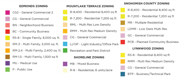
Edmonds is actively planning land use changes for its stretch of SR-99. Running from 244th St SW to just north of 220th SW, the city has a patchwork of urban commercial and residential zoning. The city has selected a study area along the corridor that ranges one to six blocks from SR-99 and Edmonds Way (east of SR-99). Within the area, Edmonds has been evaluating zoning changes that would consolidate a patchwork of zoning down to one primary zone and be paired with consistent development regulations. However, certain residential areas and Swedish Medical Center would retain their existing zoning under the preferred zoning alternative.
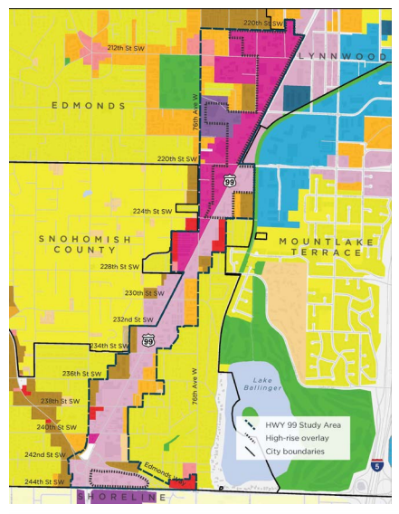
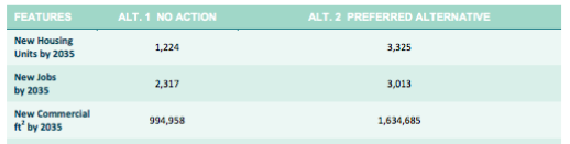
To support possible zoning and development regulation changes, the city has issued a Final Environmental Impact Statement. Zoning changes would accommodate substantial increases in the number of new housing units and jobs by 2035. A net increase of 2,101 homes and 696 jobs are possible under the proposed zoning changes over the status quo.
Areas proposed for zoning changes would go to General Commercial (GC), which would allow 75-foot tall buildings. For the GC zone itself, that would be an increase of 15 feet, or one story, over existing development regulations. Community Business (BC) and Multifamily (RM) zones proposed for zoning changes to GC would see an even greater height limit increase. Both of the zones have a maximum building height of 25 feet, so conversion to GC zoning would effectively represent a 50-foot building height limit increase. Those zoning changes would also have other bulk regulations adjusted. The proposed subarea zoning is as follows:
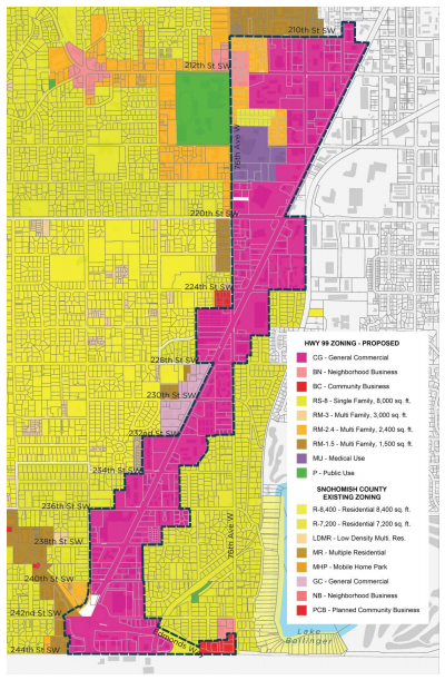
The proposed subarea zoning changes would be comprehensive including a variety of modifications to development regulations. The FEIS succinctly captures the general approach to these modifications: “In general, the proposed changes would result in a land use pattern that is more pedestrian-friendly, with buildings located closer to street frontages, fewer parking areas located between buildings and primary street frontages, more areas designed for pedestrian use, and more pedestrian infrastructure.” These types of changes are laid out in the following table:
| Development Standard | New Standard |
|---|---|
| Parking | - Non-residential uses: two stalls per 1,000 square feet of leasable area - Residential uses: Average minimum of 0.75 stalls per unit - First 3,000 square feet commercial uses within mixed-use buildings when they have a shared parking plan |
| Parking Location | - Parking areas shall not exceed a maximum of 40% of street frontage |
| Building Frontage | - A minimum of 50% of primary street frontage must have buildings within 10 feet of front property line - 50% of side and rear frontages must have buildings, walkways, or hedges at least four feet in height within 10 feet of property lines |
| Building Transparency | - At least 50% of primary building frontage facade within two and 10 feet of height, which is measured from the adjacent sidewalk, the bottom of which may not exceed four feet above the adjacent sidewalk, must be transparent with windows and doors - All other frontages require 30% transparency - Windows shall not be mirrored or have glass tinted darker than 40% |
| Pedestrian Activity Zone | - Designate a 10-foot Pedestrian Activity Zone in place of existing Type IV landscape buffer along all primary street frontages with ground floor retail; future design standards may consider special circumstances, such as auto dealer locations |
| Ground Floor Setback | - For frontages on SRR-99, require a front setback of 10 feet to accommodate a Pedestrian Activity Zone - For frontages not on SR-99, reduce frontage setbacks to five feet and encourage enhanced pedestrian realm (e.g., larger sidewalks and usable landscaping) - Keep current 15-foot setback and 10- foot landscaping requirements for lot lines adjacent to single-family residential zones |
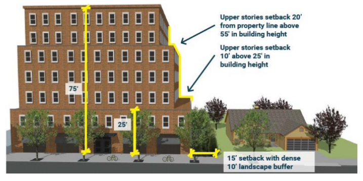
| Upper-Level Stepback | - Adjacent to single-family residential zones, provide 10-foot upper-level stepback for portions of a building above 25 feet; provide 20-foot upper-level stepback for portions of a building above 55 feet - Across the street from single-family residential zones, provide eight-foot upper-level stepback for portions of a building above 25 feet; provide 16-foot upper-level stepback for portions of a building above 55 feet |
The development regulations generally are focused on the urban design of a new urban district, but notable in the table are the development regulations that are sensitive to single-family residential areas, too, which provide upper-level stepbacks from property lines abutting those zones.
Edmonds intends to adopt specific objectives and goals for the subarea through a local plan. In June, the city published its draft subarea plan which provides a high level of specificity in the types of actions and possible programs that could be directed to the subarea. These include planned transportation improvements and recommendations on wayfinding and signage strategies, transit, and programs to deliver affordable housing. It also takes stock of background data, opportunities, and challenges:
The draft version of the subarea plan is proposed to be adopted as part of the area-wide zoning changes.
Also as part of the rezone, Edmonds hopes to adopt a Planned Action ordinance for the planning subarea, which would eliminate the need for further environmental review under SEPA (State Environmental Policy Act) for new development in the area, provided that cumulative impacts of new development projects remain below the planned level of development capacity and implement the identified mitigation strategies in the FEIS/Planned Action ordinance.
A final package of changes for the subarea could be approved on August 15th.
UPDATE 8/9/17: Updated to reflect new information on timing of approval.