The Puget Sound Regional Council (PSRC) has released a draft of the latest update to the central Puget Sound’s regional transportation plan. Required to be updated every four years, this version extends to 2050 and is intended to align with the region’s growth strategy, adopted in 2020, called VISION 2050. It envisions a transportation system with seven more passenger-only ferry lines, 30 new or expanded regional walking and rolling trails, and 43 new or expanded rapid transit lines to accommodate moving people and goods in a region expected to add 1.6 million additional residents in the coming years.
At the heart of the plan is the PSRC’s Regional Capacity Project list. This is a database of dozens of transportation projects planned in the coming years that expand the capacity of the transportation system, for users of all modes: regional trails, frequent transit lines, and road projects. To be on the list, a project must receive a vote of approval from both PSRC’s Transportation Policy Board and its Executive Board, both made up of elected leaders from all over the region. PSRC has created an online visualization tool that lets users explore the capacity projects on a map lined up with other conditions of the transportation system.
The list currently includes a number of roadway projects with the express purpose of expanding general purpose capacity, like a $93 million project to add a lane to I-5 around Lake City Way NE in Seattle by 2030, or a $228 million project to add lanes to SR-167 in Kent by the same year. The primary purpose of these projects is to reduce traffic congestion: a task that the plan readily admits it will not achieve, with overall regional congestion projected to increase by 4% by 2050, despite the billions that would be spent under the plan.
However, the list also includes a huge number of regional capacity projects defined by PSRC as “multimodal.” This descriptor is applied to projects that are supposed to benefit multiple users, such as people walking, biking, and driving. Yet despite all being labeled as multimodal, the projects vary wildly in terms of what those benefits are and who they benefit.
Per the plan, multimodal projects account for 51% of the regional capacity projects, but this percentage is misleading. “Many multimodal projects include roadway capacity improvements to relieve traffic congestion, but also provide new or enhanced facilities to improve travel for people walking, biking, or using transit,” the plan says. Yet, a closer look at these enhancements benefiting other users reveals they are often secondary to expanding roadway capacity for drivers.

Let’s dive into the details of some of these “multimodal” projects. One of them is a $190 million WSDOT project to expand the interchange of SR-18 and I-90 near Snoqualmie and widen a stretch of SR-18 south of the interchange. According to PSRC’s description of the project it goals is to “[m]odify the existing interchange configuration and widen SR-18 to four lanes between I-90 and Deep Creek with pedestrian and bicycle improvements.”
The project has already been funded by the state legislature, and is much further along in the design process than many of the others planned through 2050, so we can look at what those planned pedestrian and bicycle improvements are. The expanded interchange will take the form of a Diverging Diamond Interchange (DDI), a trendy interchange type state DOTs have started utilizing more and more to keep traffic flowing. The pedestrian and bicycle improvements referenced include a relatively wide path that allows people on bikes to navigate the angling on and off ramps. This is at best pedestrian and bicycle accommodation, not really an improvement focused around improving mobility for people walking and rolling.

A planned regional trail that would connect Snoqualmie with points south all the way to Auburn through the interchange is not funded by WSDOT, and is actually a completely different project on the list, at a separate cost of $110 million. The plan lists a completion date for that trail of 2050, compared to 2025 for the interchange, and it will be up to King County to find the money to fund it.
The expansion of SR-18 continues with another project in the regional capacity project list: continuing the expansion of SR-18 to four lanes south of where the previous project leaves off, at Deep Creek, all the way to the next interchange at Issaquah-Hobart Road. PSRC lists the cost for this project at nearly $162 million, but last week the Issaquah City Council was told in a briefing on the project that there was now a “funding target” of $640 million for the highway expansion project.
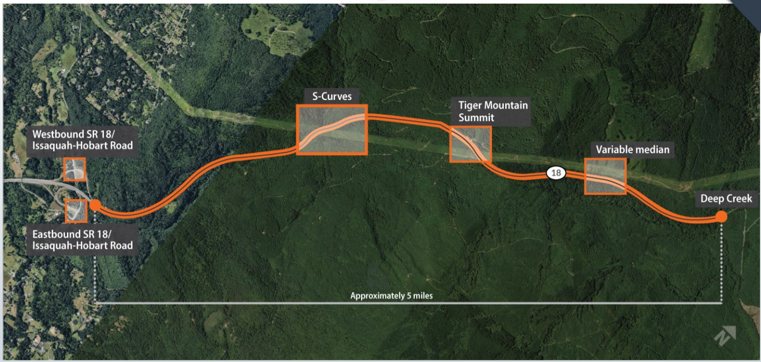
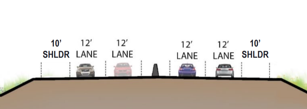
This project is dubbed multimodal as well, but what are the pedestrian and bicycle elements here? Project designer Gordon Roycroft of WSP, consulting on the project, told the Issaquah City Council that the ten foot shoulders on the expanded highway are a pedestrian and bicycle facility. “The wide shoulders will accommodate non-motorized users along the full corridor length,” a 2020 memo on design alternatives stated. However, this is in conflict with WSDOT’s own active transportation plan, which notes that “On many highways pedestrians may also use roadway shoulders, though shoulders are considered an extension of the roadway and are not typically considered pedestrian facilities.”
That same memo detailed a possible pedestrian overpass at the Tiger Mountain Summit trail entrance, which would have enabled people biking to Tiger Mountain via SR-18 to cross the roadway safely. It was eliminated from the project in part due to “land use, property rights, and funding issues.” This is a great illustration of how bike and pedestrian add-on elements can often be dropped from multimodal projects like this due to cost concerns. Calling the expansion of SR-18 a multimodal project is clearly false and misleading.
But these SR-18 expansion projects are just one example. Overall, completion of the plan as currently envisioned would add 106 new lane miles (meaning one mile of lane in one direction of travel) onto the region’s freeway system, and 119 lane miles to the region’s arterial road network. What’s missing is a serious consideration of the environmental impact of not just leaving the majority of our region’s roadway network intact but adding onto it. More and more information is being learned about even low-levels of particle emissions from sources that include auto emissions. “Older Americans who regularly breathe even low levels of pollution from smokestacks, automobile exhaust, wildfires and other sources face a greater chance of dying early,” was how the New York Times summarized the results of a four year study on particle emissions released just this week.
In order for a project to be included in the list, it must present environmental documentation to PSRC, including final environmental impact statements under the state environmental policy act (SEPA) and the National Environmental Policy Act (NEPA). But environmental documentation under SEPA frequently overplays the impact that reducing traffic congestion can have on air quality and greenhouse gas emissions and generally does not address the impact of induced demand, or additional trips getting made because the street is providing quicker travel times.
“For 90 years, we have known that building new lanes creates new vehicle trips that fill those lanes, and for 90 years, we have mostly ignored this fundamental law while repeating the same mistakes at great cost,” Beth Osborne, the director of the national advocacy organization Transportation for America, has noted.
Last year, the Rocky Mountain Institute created a calculator that estimates the impacts of adding new lane miles in different regions of the country by showing the increase in vehicle miles traveled and the associated emissions. In King County, it estimates every added lane mile would generate 2 to 3 million more vehicle miles traveled per year. The 225 added lane miles could add 566 million miles per year, and likely more, because some portion of those lane miles would be added directly to the interstate system, which is in higher demand.
In a recent report on state vehicle miles traveled (VMT) commissioned by the legislature, the Washington State Department of Transportation itself makes the case against expanding highway infrastructure. “Potential highway expansion, as opposed to other transportation investments, generally increases vehicle miles of travel by making access to land further away more attractive than it previously was. On the other hand, investing in transportation efficient communities can lower vehicle miles of travel by locating people closer to the activities they wish to engage in and providing them with transportation choices other than driving alone.”
This viewpoint was echoed by WSDOT Secretary Roger Millar during his opening presentation to the transportation committees in the state legislature earlier this month. “Addressing congestion through adding lanes to the interstate system is not financially feasible, it’s not economically feasible, it’s not environmentally feasible…it’s not going to happen. So we need to think, after spending the money we’ve spent on addressing congestion and looking at what it would cost with a highway solution, we get to the point where we need to think about maybe doing things differently,” Millar told the members of the House transportation committee.
The regional transportation plan is an ideal venue to think about doing things differently as WSDOT’s highest ranking official suggests. The regional elected leaders who guide the PRSC should push for a comprehensive look at whether these projects will truly achieve our regional goals. Hiding them behind a “multimodal” label that means very little actually moves us in the wrong direction.
The PSRC has an online open house on the Regional Transportation Plan available through the end of the comment period on February 28. After that comment period, the Transportation Policy Board is expected to discuss changes proposed and adopt the final plan by this spring.