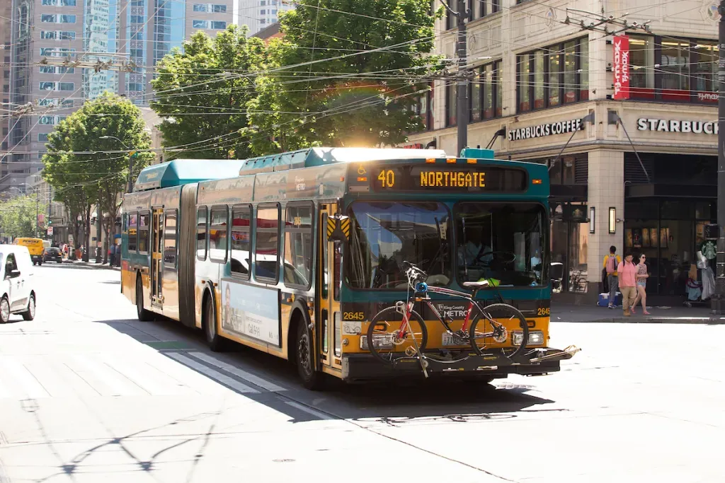
The Seattle Department of Transportation (SDOT) has been planning upgrades to King County Metro Route 40, one of its planned “Transit Plus Multimodal Corridor” projects, since 2019. Scheduled to be completed by 2024, the project is more substantial than some of the other bus corridor upgrades (like Route 48) being planned.
With a $26 million budget, SDOT plans to add bus lanes to significant portions of the 40’s route, including Westlake Avenue N, N 36th Street, and Leary Avenue NE, with a goal of reducing peak-hour travel times by up to 10% and dramatically improving the reliability of trips along the corridor running between Downtown, Fremont, Ballard, Crown Hill and Northgate. Prior to the Covid pandemic, Route 40 had the third highest bus ridership in Metro’s entire system, and according to the agency, it has remained one of the highest ridership routes.
Despite Route 40’s importance as a key transit line, reallocating street space for the improvement project, particularly in the industrial zone around Ballard, has received significant pushback. Most notably this emerged last year when the president of the North Seattle Industrial Association, Eugene Wasserman, called for the entire project to be restarted so that freight interests could be more fully centered.
“It appears to the Maritime/Industrial community that SDOT is willing to sacrifice the viability of maritime/industrial businesses and their employees so that Amazon workers can get to their offices 5 minutes earlier,” Wasserman wrote to SDOT last spring. But so far, there aren’t signs that city leadership is ready to water down the project in response to these requests.
Late last month, SDOT released its most up-to-date concepts for the project, and while there are a few major tweaks, the project largely remains as proposed all along — with a couple exceptions. Through June 19, there’s also a survey available to provide feedback on the changes, the most significant of which will be explained here.
Leary Way
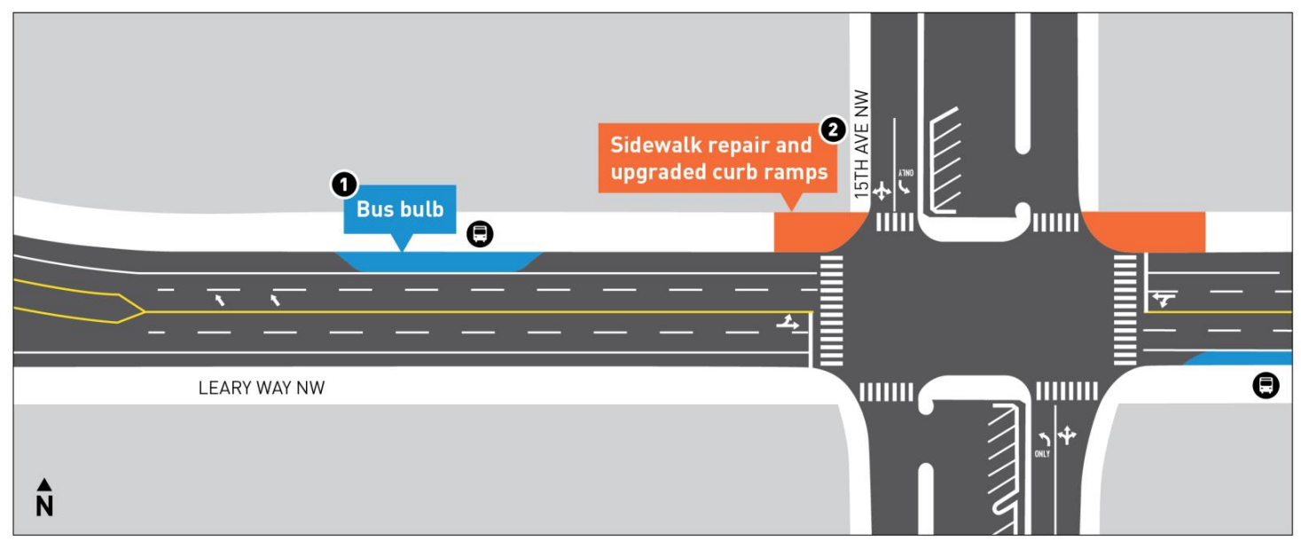
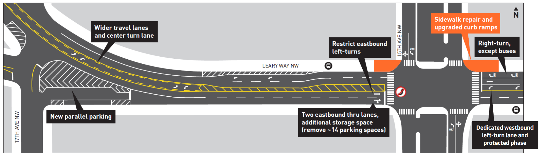
Perhaps the most important change that’s been announced involves the area around Leary Way NW and 15th Avenue NW, the stretch on either side of the Ballard Bridge underpass. Last year, the plan was to rechannel Leary Way west of 15th, removing parking and restricting eastbound left turns from Leary onto 15th. This intersection is one of the worst in the city to navigate on foot, and while the proposed design certainly wouldn’t have made it a pedestrian haven, but would have been a step in the right direction.
The 2022 design for this stretch eliminates nearly all changes, which SDOT says will “better serve large freight vehicles.” Apart from new curb ramps (required by law) the only improvements planned here now are bus bulbs allowing buses to stop in-lane on either side of 15th. The travel lane was actually proposed to be widened west of 15th in SDOT’s original plan for this area, but this change appears to be the biggest concession so far to freight advocates in this project.
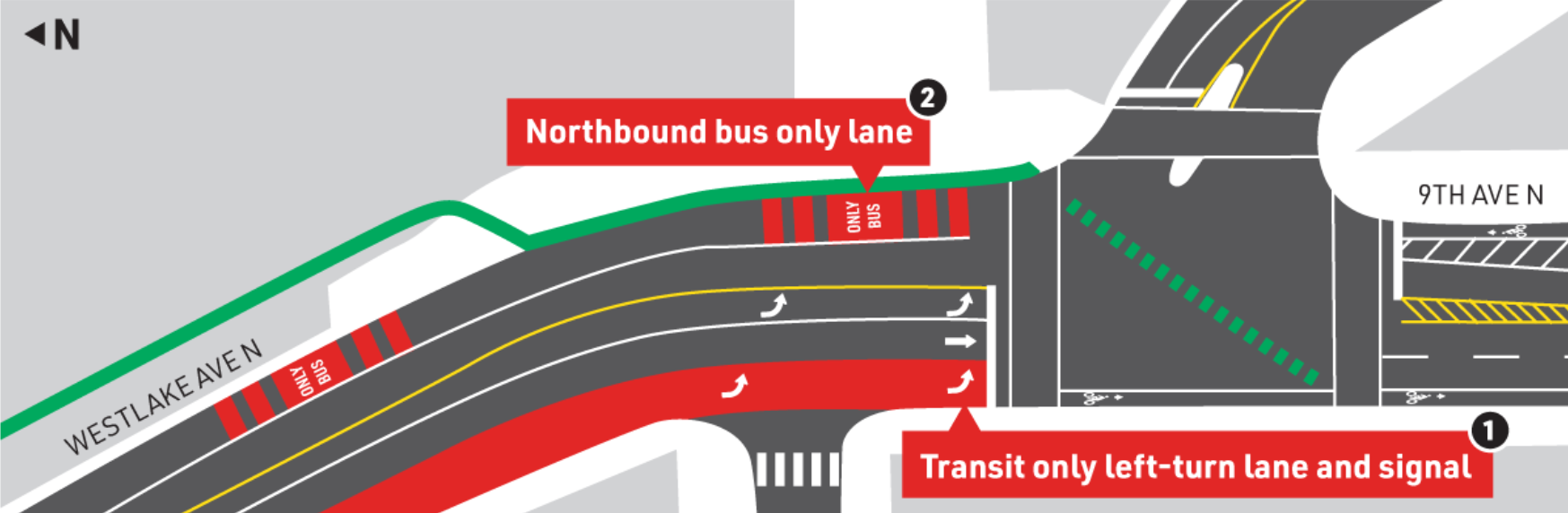
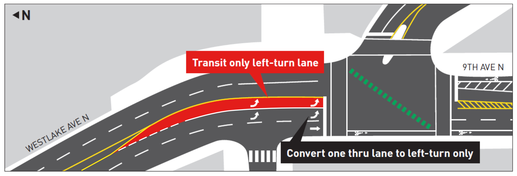
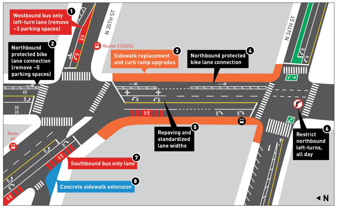
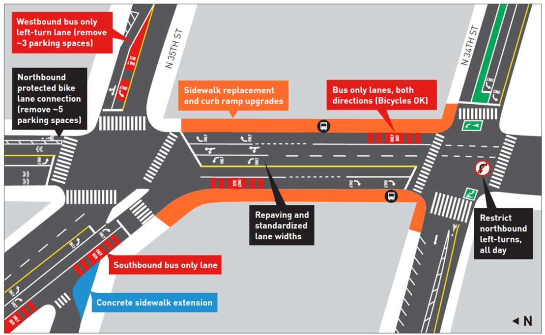
Fremont AvenueAnother big change in the project since last year is at the hectic block of Fremont Avenue between N 34th and N 35th Street. This block is currently home to shared bus stops for Routes 31, 32, 62 in addition to the 40. Previously, SDOT was proposing to paint the curb lanes on either side of the street red, with right turns still allowed. People on bikes would be allowed to use that bus/turn lane to connect from N 34th Street to a one-block-stretch of new protected bike lane on Fremont Avenue between N 35th and N 36th Street, the only new protected bike lane planned as part of this project.The 2022 design extends that northbound protected bike lane to this block as well, eliminating the dedicated space for buses on this block and requiring the relocation of the northbound bus stops for all four of those buses: the 31, 32, and 62 would go around the corner on N 35th and the route 40 stop would go to the north side of Fremont Place.This is a big step backwards for transit riders on this corridor. The Fremont Avenue bus stops are heavily used for people heading to the heart of Fremont: forcing riders to wait to get through two light cycles, at both 34th and 35th after slogging over the Fremont Bridge isn’t really workable. Transfers between northbound buses will require crossing two streets when today there are no crossings required.It’s not exactly fair to paint this as a fight between people on bikes and buses though: with three other general purpose lanes on Fremont, there should be a way to maintain a relatively separated bike connection and a northbound bus stop here. The widths of most lanes on this block are actually set to increase. But there does need to be a way to make it work that doesn’t move these highly used bus stops.Finally, there isn’t any plan to extend the protected bike lane on Fremont Avenue any further north, so it would stay a two-block-long facility for at least a few years.Bus lane relocation at 9th Avenue NAnother change is pretty minor, but should benefit buses on Westlake. Originally buses were going to need to merge into a bus-only left turn lane just at 9th Avenue N and Westlake Avenue N. That would have been a tough merge to make during rush hour. Now the plans show the bus lane staying at the curb to the intersection, where a queue jump will allow buses to have a head start when continuing south on Westlake. The northbound bus lane will also extend even further south at the intersection with 9th Avenue N. Good news for riders.New crossing at Westlake and HalladayAlong with these updates, SDOT is announcing they have added a new signalized pedestrian crossing to the project, along Westlake Avenue at Halladay Street. This is a long stretch without a southbound bus stop at all, in part because of the lack of a crossing.Along with that change, SDOT and Metro propose to remove the stop pairs at 8th Avenue N, which are not far from the stops at Galer Street.
As design progresses, it’s increasingly unlikely that major changes will happen to this project. However, it will be interesting to see whether the Harrell Administration decides to take a different direction with this transit rider-focused project, even as the mayor has famously said he is leading with transit. Take the survey through Sunday June 19.
Business Interests Take Aim At Critical North Seattle Transit Corridor Improvements