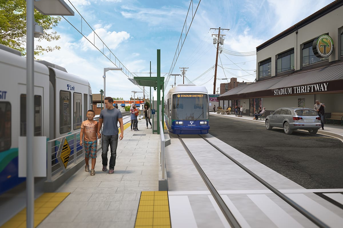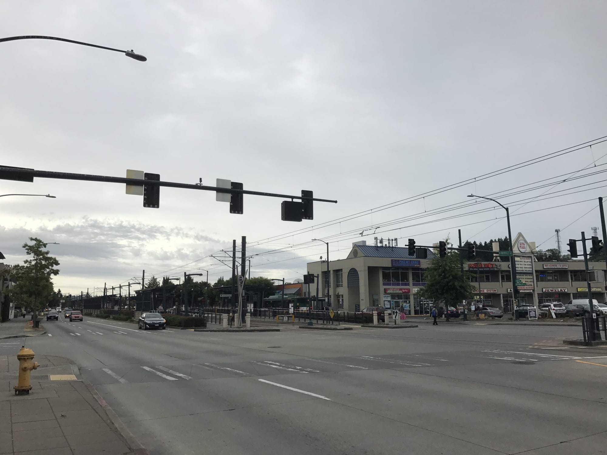
Rainier Valley has seen more than its due share of collisions over the years. Martin Luther King Jr. Way S is a particularly problematic spot where serious injuries and fatalities are common. Intersections are massive. The street has may wide lanes separated by light rail tracks running down the median. Narrow pedestrian refuges, narrow station platforms, and long wait times to get a walk signal do pedestrians no favors. Collisions with light rail vehicles happen frequently with one collision every 40 days prior to the pandemic and what seems to be even more often since.
In response to this, Sound Transit has been working on several projects to deal with the safety performance of at-grade light rail segments. The agency recently improved lighting at Mount Baker Station and is planning similar improvements for other at-grade stations. Last fall, Sound Transit piloted the use of louder warning bell chimes during the day, and it plans to implement a handful of other small safety improvements over the next few years.
Buttressing these safety upgrades is a $2 million allocation in the agency’s recently-approved 2023 budget for four at-grade safety enhancement programs this year, but that funding falls far short of the need. Sound Transit plans to report back to the agency board later in the year with a set of concrete recommendations to improve the situation, which might include some of the recommendations that the agency issued in a lengthy technical report last year.
At-grade safety mitigation programs underway
Of the four safety enhancement programs, the most initially impactful will be a new signage effort in the Rainier Valley. Sound Transit is planning to install pedestrian warning signs along the at-grade light rail corridor between Mount Baker and Rainier Beach by the end of 2024. At signalized intersections, warning signs will contain dynamic messaging. The agency plans to work through signage design, procurement, and coordination with the Seattle Department of Transportation (SDOT) this year and the project cost is relatively modest at about $1.1 million, $607,000 of which is funded for 2023 work. Sound Transit is also working with SDOT to install pavement markings and restriping this year. Pavement markings will include notices to pedestrians to “look both ways” before making crossings.
The other three programs are part of Sound Transit’s larger efforts to look at hazards with at-grade Link segments and appropriate mitigations to them. These are the Link At-Grade, SoDo MLK Hazard Mitigation, and Crossings Pre-Project and Outreach programs, which generally overlap and deal with reviewing, designing, and constructing targeted crossing enhancements that serve at-grade Link stations as well as public outreach efforts. A total of $5 million is teed up for these programs over the next two years with $936,000 to be spent on at-grade crossing safety campaigns.
But questions remain about whether these projects will bear fruit in curbing collisions. Informational safety campaigns are not the same as designing out root causes of safety problems. The same goes for warning signage.
Additional safety mitigation strategies recommended
A technical report that Sound Transit issued last year does offer some concrete ideas and strategies that could deliver higher performing safety mitigation solutions to the at-grade Rainier Valley rail segment. Most of those solutions, however, don’t come as cheaply and quickly as slapping up signage. Strategies broadly outlined in the technical report include:
| Strategy | Per Unit Cost | Maintenance | Function |
| Pedestrian signs and pavement markings | $24,000 | Replacement every 10 years for signs and three to five years for markings | Standard signs and markings identifying conflict points with trains. |
| Pedestrian swing gates | $83,000 | N/A | Easily opened barriers to increase pedestrian awareness of conflict points. |
| Pedestrian crossing gate systems | $2,490,000 | N/A | Similar to pedestrian swing gates, but are actively controlled by the train signal system to prevent entry into conflict areas when a train is present. |
| Z crossings | $166,000 | N/A | Offset crosswalks that force pedestrians to change direction at crossings, encouraging them to be more aware of their surroundings, and orient them in the direction of approaching trains. |
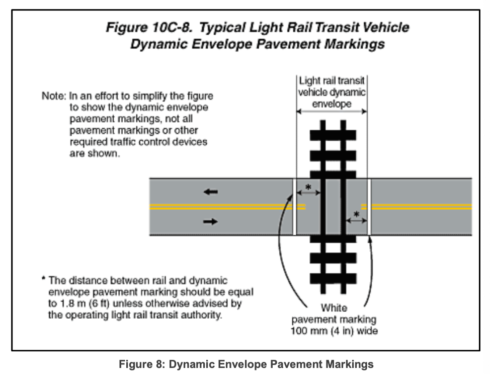
| Dynamic Train Envelope Pavement (DTEP) markings | $24,900 | Replacement every three to five years for markings | Pavement is marked with warning bars just before tracks to identify crossings. |
| LED signs | $83,000 | N/A | These are dynamic signs that light up to alert users of the roadway that a train is present or approaching. |
| Adaptive transit preemption recovery | $41,500 | N/A | The traffic signal technology that determines which signal phase to return to after a passing train based upon the longest delay but may prioritize left turns in the future. |
| Bigger pedestrian holding areas | $83,000 | N/A | Larger sidewalks and bulbs for pedestrians to act as holding areas at the station and encourage riders to choose less risky behaviors near crossings. |
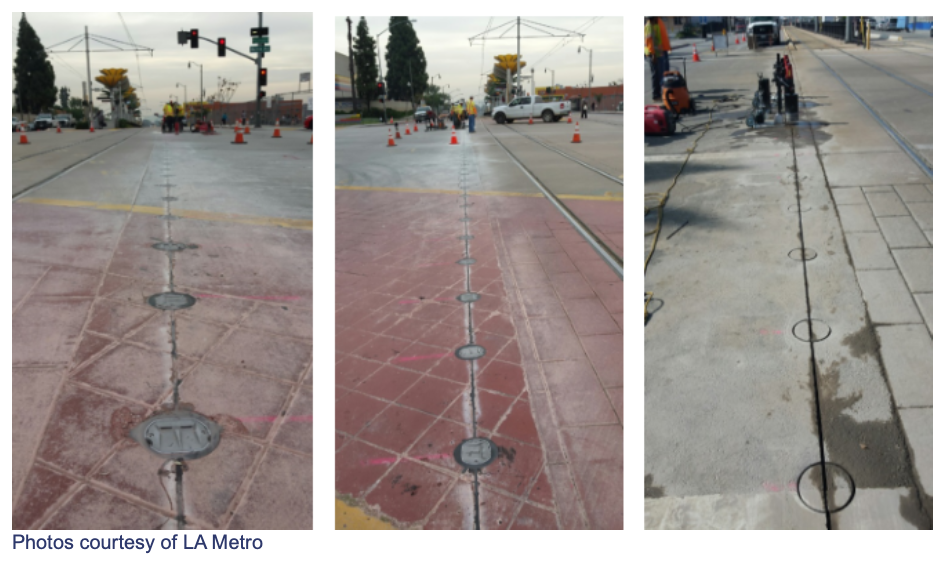
| Internally Illuminated Raised Pavement (ILRP) markings | $265,600 | Minimal maintenance | Lights in the roadway. LA Metro experimentation has shown a reduction in left-hand turn violations with special in-street illumination markings. |
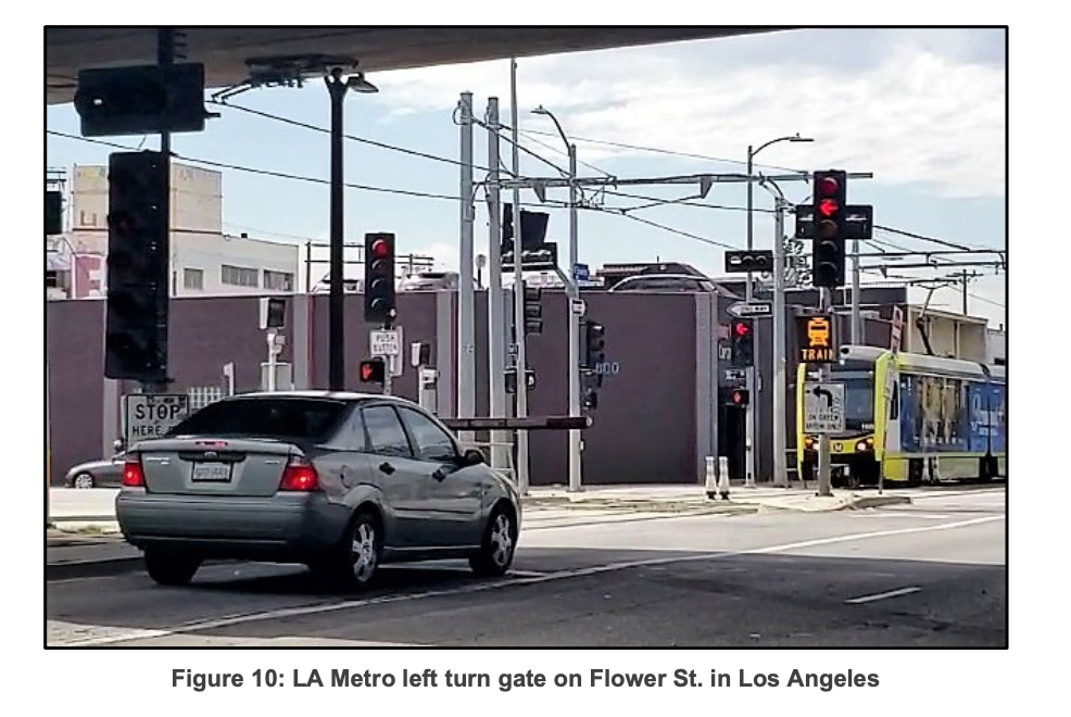
| Left turn gates | $415,000 | Repair and replacement as necessary when damaged by motorists | Gate arms in left turn lanes to prevent motorists from illegally making left turn crossings. |
| Photo enforcement of left turns | Unidentified | N/A | Photo enforcement to reduce illegal intersection crossings. Experience in Los Angeles with at-grade crossing photo enforcement has shown a 60% reduction in left turn violations. |
| Restrict intersection crossings | Unidentified | N/A | Further physical barriers to restrict lesser intersection crossings. S Dawson Street, S Webster Street, S Brandon Street, and S Kenyon Street already have some restrictions, but could establish side streets are right-in, right-out and require motorists proceed to major intersections to U-turn. |
| Installing left turn lanes and signals | Unidentified | N/A | Formalize movements already occurring at intersections and safely accommodate them with proper lanes and signals. |
| Signal phase adjustments | Unidentified | N/A | Reducing pedestrian crossing phases at signals could improve pedestrian safety |
A theme in these strategies may be obvious: left turns. More than 40% of left turn collisions happen at locations that don’t permit left turns, according to the technical report. Therefore, many of the strategies recommended are specifically designed to address restricted left turn situations by either physically removing their possibility or allowing them under safer conditions.
The technical report dives deeply intersection-by-intersection to discuss intersection details, collision events, and potential safety mitigation treatments. The latter is intriguing because it gives a window into actions that Sound Transit and partner agencies might take in the future to improve safety. Examples identified in the technical report include:
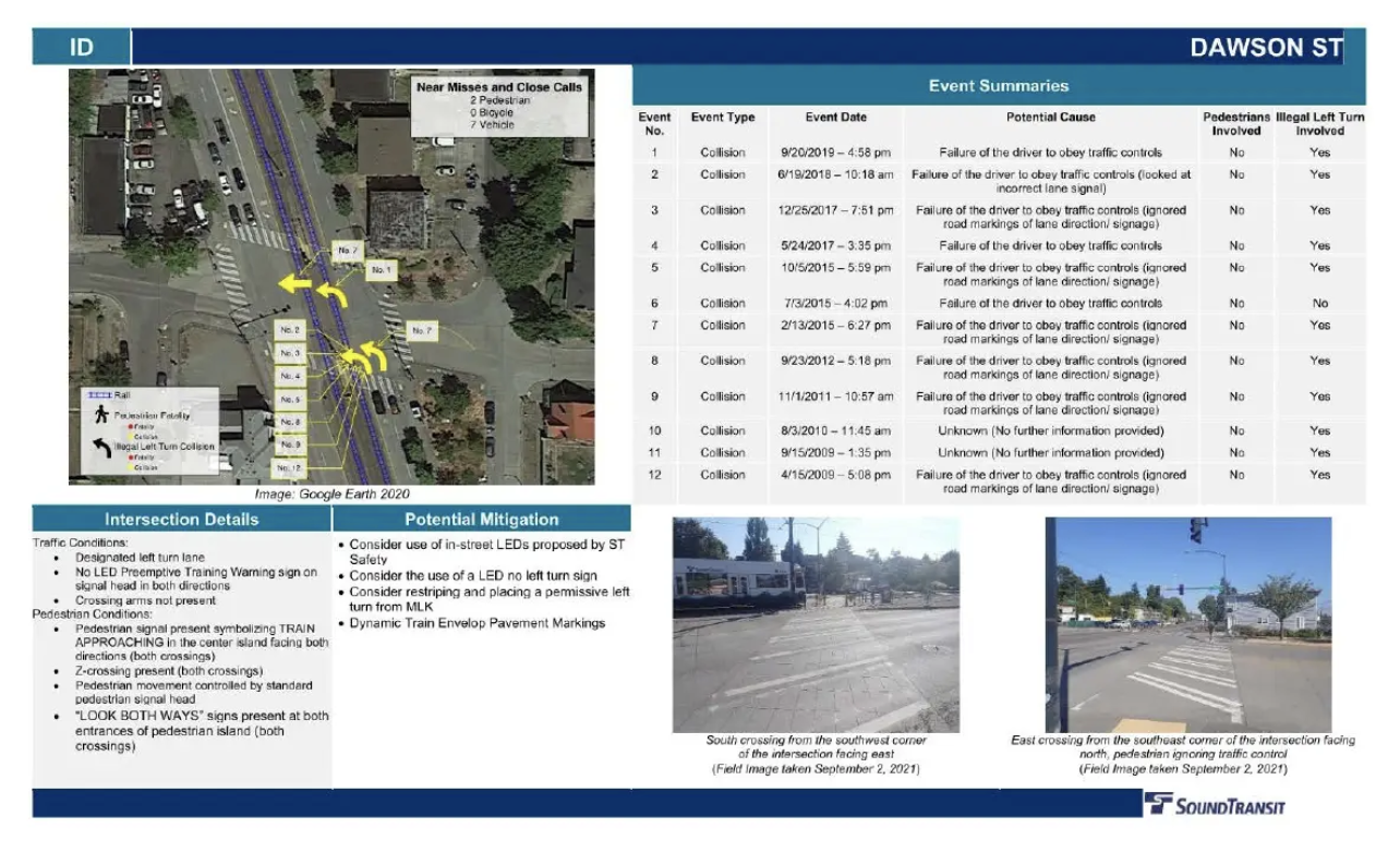
- S Dawson Street – installation of in-street pavement LEDs, permissive left turn signal, no left turn LED sign, and DTEP markings;
- S Myrtle Street – installation of pavement warnings, crossing arms, larger pedestrian holding areas, Z-crossing, pedestrian swing gates, in-street pavement LEDs, and increased pedestrian signage and pavement markings; and
- S Alaska Street – installation of directional speaker with audible warning, full volume warning bells, safety barriers, gates to prevent illegal turns, light cycle changes, DTEP markings, in-street pavement LEDs, and LED train warning sign.
These intersection safety mitigation measures are an interesting peek into Sound Transit’s thinking and they are responsive to known problems of intersections and Martin Luther King Jr. Way S as it is today. However, these identified mitigation measures are largely not funded yet.
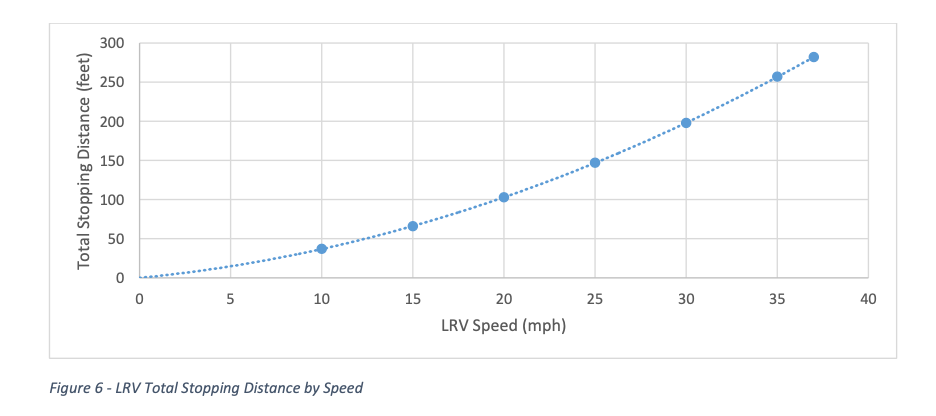
A big set of recommendations come from Link’s operator, King County Metro, which separately issued a hazard analysis and risk assessment report in 2019. In that report, Metro recommended that light rail operating speeds be reduced in the Rainier Valley corridor. Current maximum operating speeds when trains are approaching at-grade crossings and platforms are 35 mph and 30 mph, respectively. Metro recommends dropping these to 25 mph for at-grade crossings and 20 mph for platforms. Reduced speeds would allow trains to be stopped much more quickly during potential collision events. Stopping distance would be reduced from 132 feet to about 59 feet when approaching platforms. Metro ultimately believes that this could reduce the frequency and severity of collisions.
Sound Transit’s technical report does address Metro’s speed recommendations with estimated system impacts that would be created if implemented. Assuming trains were reduced to a 25 mph operating speed, travel time would increase by 41 seconds per mile (totaling about 2.5 minutes) along the Rainer Valley corridor. Sound Transit believes that this additional time could be absorbed at certain times of day because of available recovery time at the end of lines, but that may not be the case for all scheduled service. The extra travel time risks increasing operational requirements (such as a need for more equipment and operators to maintain scheduled frequencies), reducing service reliability, and increasing service costs. And for riders, the extra travel time would be noticeable for those traveling through the Rainier Valley corridor.
Reducing train speeds may be premature when so many other options remain unfunded.
As Sound Transit’s own analysis indicates, reducing trains speeds does have localized and systemic impacts. Increasing travel time and reducing reliability for transit riders, increasing staffing and vehicle needs, and increasing service costs are decidedly negative consequences. Going straight to reducing operating speeds in the corridor may be a drastic policy choice when many other solutions haven’t even been funded and implemented.
Should train speeds be reduced, that would completely call into question why a regional light rail line is even operating on the corridor. Running trains at 25 mph or below is far more suited to trams than what is supposed to be a rapid transit line. Pursuing a longer-term capital effort may be worthwhile to the region to rectify the inevitable system problems reducing train speeds would create. That could involve building an entirely new grade-separated, elevated Link alignment to bridge the Rainier Valley segment. And, the existing at-grade segment could then be converted to tram and extended so that it becomes part of the Seattle Streetcar system. That kind of solution could make the most out of the transit investments that already exist and maximize benefits and safety.
It also bears mentioning that the transit agency reports don’t fundamentally deal with the fact that Martin Luther King Jr. Way S essentially acts as a four- to five-lane surface highway. In a world where the stroad was instead a safe multimodal street with fewer car lanes actively managed by speed control devices (e.g., speed humps and raised crosswalks), fewer car crossings, shorter pedestrian crossings, tighter turning spaces, and lined with protected bike lanes, the agencies’ safety mitigation recommendations for the corridor would almost certainly be different. Trains wouldn’t have to clear car-choked intersections nearly as often and rarely with so much space of potential conflicts. That would ultimately be safer for people walking, rolling, biking, and driving. Getting buy-in and funding for that kind of change, however, would be no easy task compared to the recommendations Metro and Sound Transit have put forth that more or less accept the status quo as a given.
Ultimately, Sound Transit and local agencies have many strategies to improve safety along Martin Luther King Jr. Way S. When and which recommendations will be implemented to reduce serious and fatal collisions is unclear, but one thing’s for sure: there’s certainly no time like the present to start.