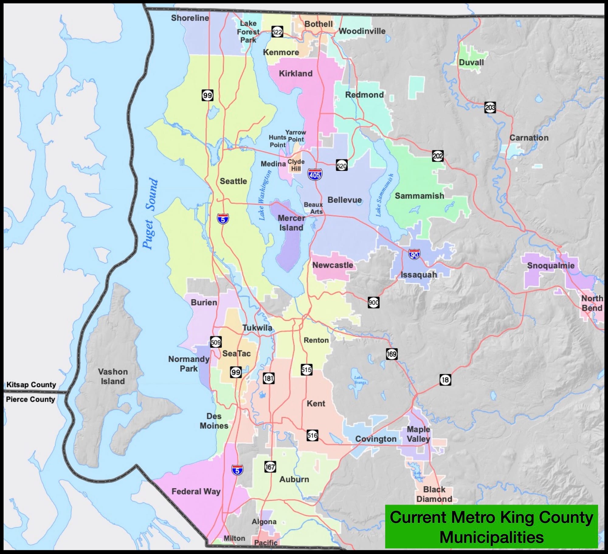
Metropolitan King County has 31 separate jurisdictions orbiting Seattle. Let’s cut that down by a lot.
It hasn’t always been this way. For the first century of its existence, King County was dotted by only a dozen cities. Seattle came first, followed by Kent, Auburn, and Issaquah. A few towns emerged and were annexed by their neighbors, like Ballard and Columbia City. The municipalities tended to focus around a waterfront (Renton, Kirkland) or logging (Bothell, Milton – literally Mill Town).
Then, in two waves, the County was hacked into smaller and smaller bits.
The first wave coincided with the rise of the automobile and the civil rights movement, one allowing residents to enclave themselves from the other. Eleven new cities were founded between 1953 and 1961 like Mercer Island, Bellevue, and all the tiny villages pretending to be cities orbiting that Eastside like Medina, Clyde Hill, and the Points.
The second wave came in 1989 when the state instituted new rules for founding a city and encouraged them to fill in the newly made Urban Growth Boundary. Another 10 cities popped up in 10 years like SeaTac, Federal Way, and Sammamish.
Now with almost three dozen separate jurisdictions, King County is crossed by countless boundaries that institute different zoning, policing, and trash pickup on, in some cases, opposite sides of the same street. The County is a patchwork of conflicting laws and random land uses all under the siren call of “local control.” Some towns rent cops from others. Some majority-minority neighborhoods are conveniently skipped, like Skyway. There are 14 separate school districts, just between the mountains and Puget Sound.
Taming those boundaries should be a priority for the region, if not to improve governance and address regional issues, then just to make some reasonable looking maps. Interestingly, those revised maps tell us a lot about the balkanized, divided situation our region currently faces.
Data descriptions and explanation are at the bottom of this article.
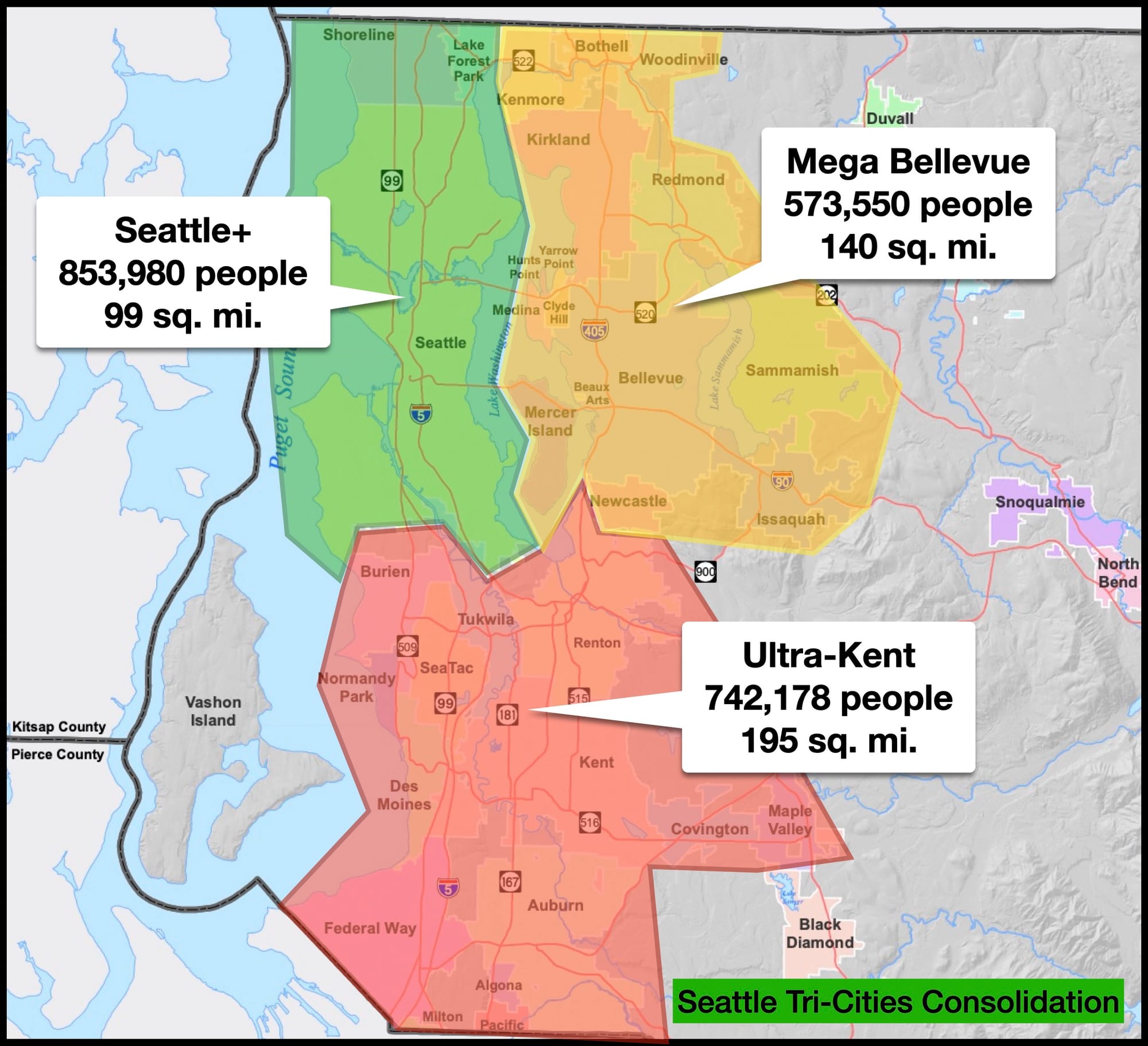
The Three Body Solution
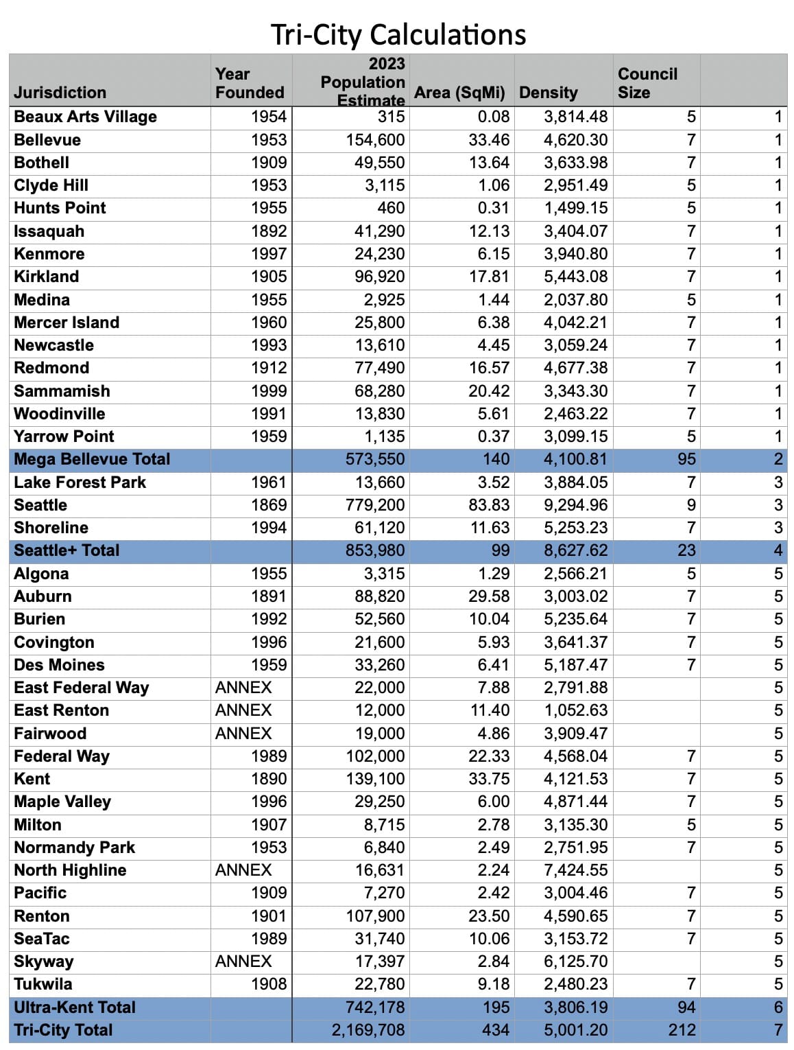
The first potential city consolidation concept is the simplest: three cities around Lake Washington. Merge cities into Mega-Bellevue to the east, an expansive Ultra-Kent to the south, and Seattle+ to the west. Really, such a consolidation accomplishes the biggest goal, wiping out every mini-jurisdiction in an easy swoop. Each of the new cities gets a major piece of infrastructure like the port, the airport, or highways. Each gets a lot of Sound Transit stops. And there is a location of both Dick’s Burgers and Uwajimaya in each new city.
Should the whole region be a single city? I would argue against it. The sides of the Lake have different enough interests that some local control and competition is warranted. Just not the micromanaging busybodies we have now.
More interesting is how consolidating all of metropolitan King County into three cities changes the region on the national level. Adding 70,000 people from Shoreline and Lake Forest Park would not boost Seattle’s rankings. Seattle+ would remain the 17th largest city behind the insufferable Indianapolis, which is not a real place. Mega Bellevue would climb from slot #185 to become the 30th largest US city between Boston and Baltimore. Ultra Kent would catapult from the 211th largest city in the country to #18, right behind Seattle and ahead of San Francisco. Density-wise, all three jurisdictions would have more people per square mile than at least half of the 30 largest US cities. Not a surprise as that list includes Houston, Jacksonville, and Oklahoma City (also not a real place).
Over-division is not just keeping regional powers from national rankings, but global as well. On the state level, all three cities would be among the largest jurisdictions in the state, larger than any other Washington city or county save for all of Pierce County, all of Snohomish County, and King County itself. Economically, King County represents half of the state’s gross domestic product, some $377 billion of the state’s $725 billion productivity. Proportionally, the three cities would have economies the size of countries, close to #61 Morocco (Seattle+ $141B), #71 Angola (Mega Bellevue $95B), and #63 Cuba (Ultra Kent $123B).
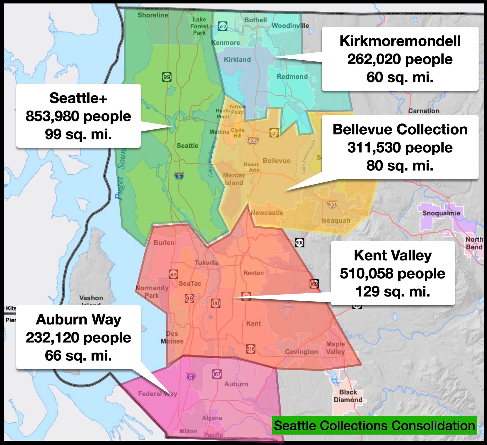
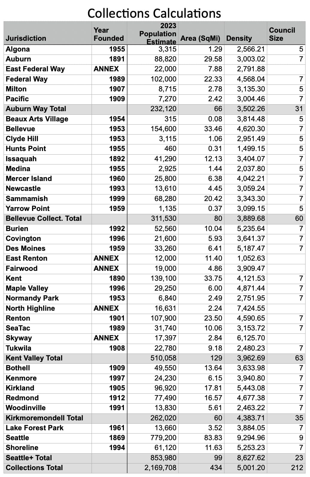
Collecting Five Cities
The second consolidation possibility is a smaller clustering of the cities based on proximity. The method here is that five of the biggest towns get to pick off their neighbors. Again, Seattle gets to annex north to the King County line, picking up Lake Forest Park and Shoreline, a city that was manufactured in 1994 strictly to prevent Seattle from crossing 145th Street. Bellevue gets to collect its satellites as well as the foothills along I-90. South King County gets split in two, divided so each new town gets Puget Sound waterfront. Technically Federal Way is the larger city, but Auburn gets first naming rights because it’s older. A situation known to younger siblings everywhere. The northeast metro corner gets to cluster around a Panera or whatever it is that exists up there in Microsoft land. It’s a whimsical, forested, elven place we’ll call Kirkmoremondell.
In a way, this is more of a one-Costco per city arrangement, although the still expansive Kent Valley and the very vertical Seattle+ each get two. It could be Home Depot or Nordstrom Rack or any other repeated corporate box, they just scream that your town is not special. The current rarity of good development in the region owes a lot to squabbling micro-jurisdictions being played off one another.
Cities compete for these stores because they bring in a one-time infusion of development revenue that obscures the long term, dwindling stream of property taxes. A regional configuration collecting together cities into larger jurisdictions may actually do well in giving the new cities the fortitude to decline poor development. Currently, Bellevue and Seattle leverage their larger sway to compel stronger developments like the Spring District and the ever growing U District. Pulling together small towns into larger cities could cut down on a lot of the region’s repetitive commercial garbage developments.
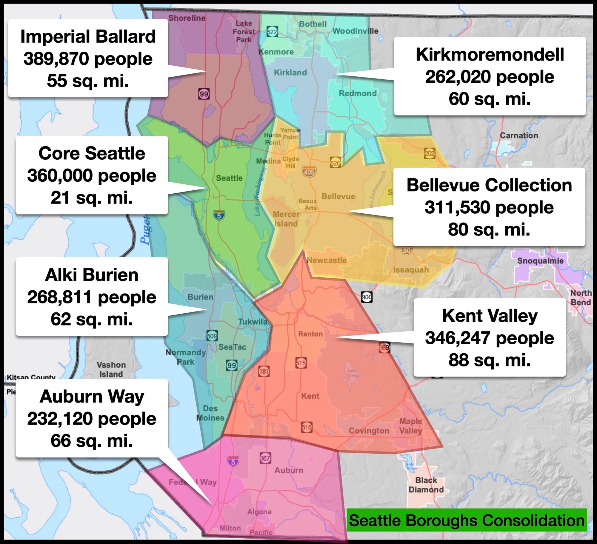
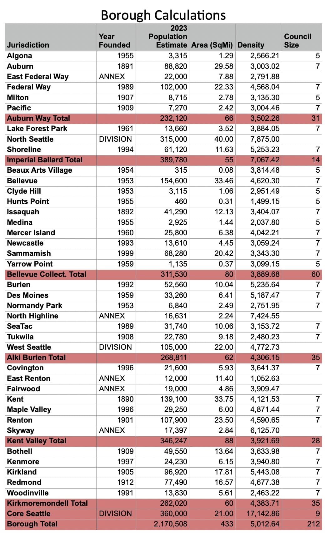
The Seven Seattle Boroughs
A third consolidation option considers whether the issue is not Tetris-ing together a bunch of towns to achieve a Seattle. What happens if the biggest city gets divided up for balance? There are 2.1 million people in incorporated King County, that’s a pretty easy number to divide by seven. It’s possible to somewhat equalize population across seven metro jurisdictions, but it would require the biggest to go from large to small.
To borrow the term from New York, a borough arrangement could see Core Seattle standing on its own in a similar position to Manhattan. West Seattle could join the jurisdictions running between I-5 and the Sound from Alki through Burien. And Ballard could become the Nordic empire it was always destined to be, north of the Ship Canal separating from Downtown and joining Shoreline. With between 250,000 and 350,000 people each, seven boroughs creates a weirdly balanced map.
Also notable about a Seven Boroughs plan is how certain resources get split. The industrial Duwamish Valley and the vital Ship Canal end up with jurisdiction lines running down the middle. Five cities have waterfront on Lake Washington.
It’s not that these numbers are excessive. The Duwamish currently runs through parts of seven separate jurisdictions. Lake Washington is bounded by 12 jurisdictions and unincorporated Skyway. The Seven Boroughs arrangement calls out the fact that the current fractured city boundaries shred the interests of regional assets to prevent solutions to regional issues. It is barely possible to get agreement on pressing needs because of King County’s current balkanization. Having only seven boroughs, roughly equal, would be an improvement.
A City-Sized Council
The true barrier to smarter local governance is not coming up with ways to cut the pie. The problem is getting agreement from the hundreds of local council members and mayors empowered by the current configuration. Across the 32 metro King County jurisdictions, there are 212 city council members.
Now, I’m on record as saying that bigger cities should have more city council members. It’s not the absolute number that’s a problem. If the borough city of Kirkmoremondell wanted to have a 60-person city council for its quarter-million people, more power to them. But right now, these fractured mini-kingdoms incentivize their leaders to pull against every other city council in the region.
City councils are not just about governing inside town limits. They are lobbyists at the county, state, and regional levels. They get voting positions on Sound Transit and Puget Sound Regional Council (PSRC) committees. They get deference when testifying in Olympia and a megaphone through the Association of Washington Cities.
So, on top of the land use fights and the regional non-cooperation, the balance of representation in the region is broken. First, there are still unincorporated areas like Skyway and Highland that do not get any benefit of a city council, that also are some of the region’s most diverse neighborhoods. There are only three non-Seattle cities in King County that have a population larger than a single Seattle City Council district. Only Bellevue, Kent, and Renton have more than 105,000 people, the population represented by each Seattle Councilmember. With seven member councils each, their council members individually represent between 15,000-22,000 people.
Going the other way, there is a population threshold below which a city council turns from a governing body into an angry coffee club. When a 300-person town like Beaux Arts Village has a five-member council, almost 2% of its residents are members.
Governance is broken when such an all-residential micro-city gets the giant civic benefits of living near the tech, arts, and financial hub of the Northwest, but can run its 1-per-60 people council members to complain against zoning reform and regional initiatives. For Seattle to have that level of representation, it would need 12,986 councilmembers. That council would be larger than nine of the metro cities, or the smallest six combined (Beaux Arts Village included).
Shattering metro King County into 32 different jurisdictions creates this lopsided type of governance. Balkanization carves up regional resources and prevents us from addressing larger issues. Patchwork governance creates enclaves that big box stores and companies can play off each other for concessions. And division that puts fiefdoms first is preventing us from flexing real muscle in the national discourse. Three dozen introverted and self-serving towns can’t pull us out of the issues we face. Many can’t pull their own weight. The only thing they do pull is the region apart.
The Patchwork City: What Gaps and Overlaps in City Boundaries Tell Us about Values
Your Data Footnotes!
Jump back to top. Here are the basic caveats for the calculations used in this article. Population data, area, and density for established jurisdictions comes from the Washington Department of Commerce, Office of Financial Management April 1, 2023 population estimate. Six King County cities – Skykomish, Duvall, Carnation, Snoqualmie, North Ben, and Enumclaw – are omitted from the calculations though they are technically within the Urban Growth Boundary because they are separated by an air gap. Black Diamond was omitted, though it is attached to Maple Valley, because there are other plans for that in a column at a later date. Dates of incorporation come from History Link. Jurisdictions that cross the boundary of Snohomish or Pierce county are counted as a whole. Unincorporated area population estimates come from the most recent figures available from the US Census or the King County Annexation Area files. Population estimates and area for a divided Seattle come from the city’s Redistricting commission.