The agency is seeking feedback on its initial pedestrian, bike, bus, and transit-oriented development plans near its four planned West Seattle light rail stations.
Sound Transit recently reached out to communities on the West Seattle Link Extension to gauge priorities around station area planning. The agency was specifically looking into support for particular station entrance design approaches, station access features, and transit-oriented development uses. Sound Transit also offered a closer look into how stations might be set up.
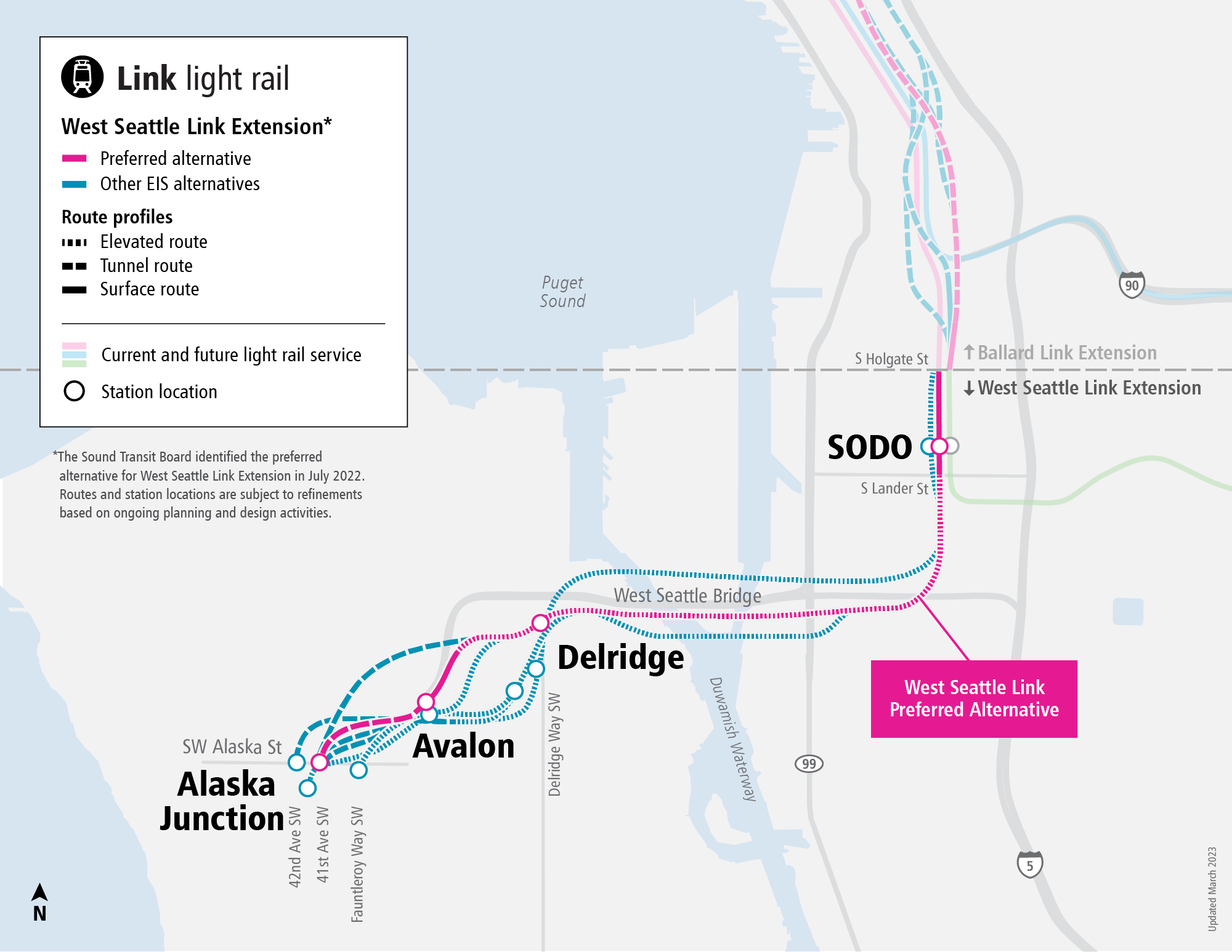
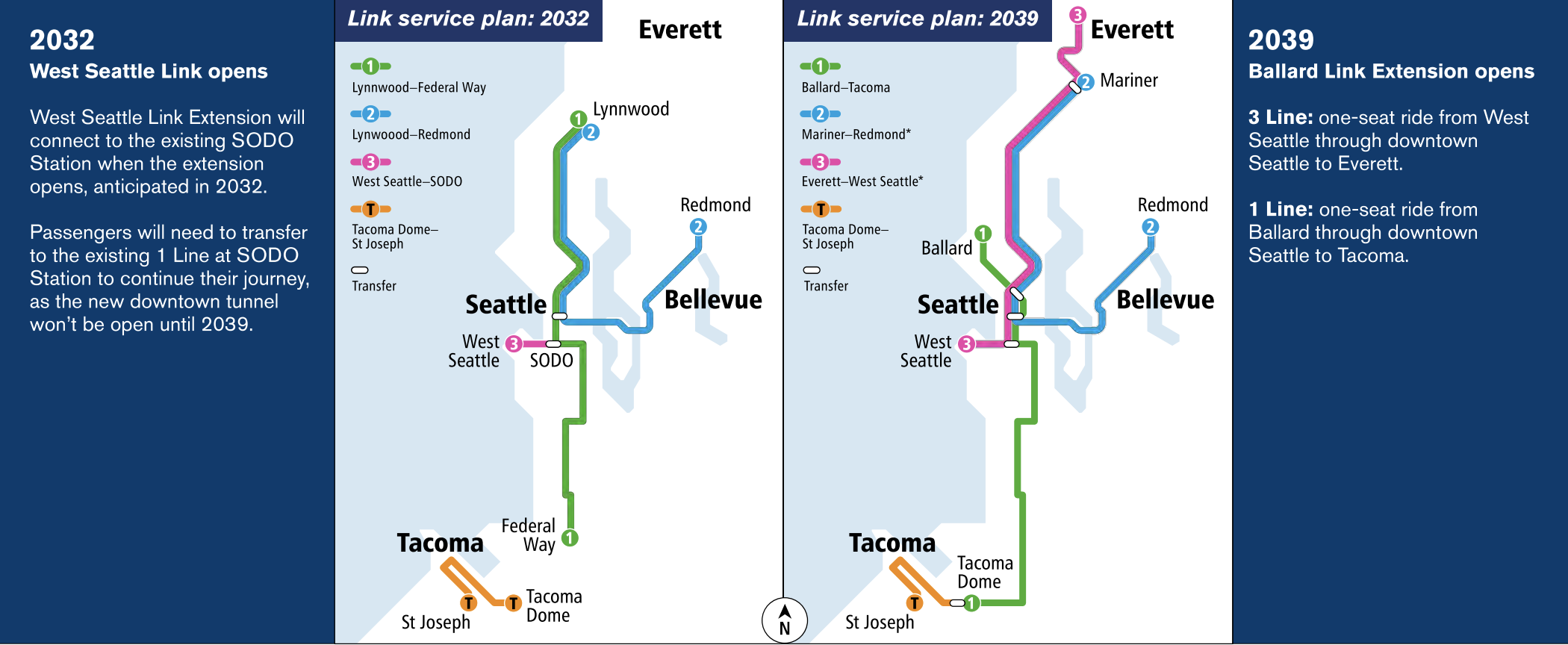
Barring further delay, the West Seattle Link Extension is slated to open sometime in 2032 as the 3 Line. It would initially come with just four stations serving Alaska Junction, Avalon, Delridge, and SoDo. Service on the line would operate as a short stub with trains terminating at SoDo station, requiring a transfer to the 1 Line to continue north, east, or south. Then in 2039, if all goes according to plan, the Ballard Link Extension would open, allowing for 3 Line trains to use the existing Downtown Seattle Transit Tunnel to continue all the way to Everett, under the agency’s “split spine” service concept.
Alaska Junction station area planning
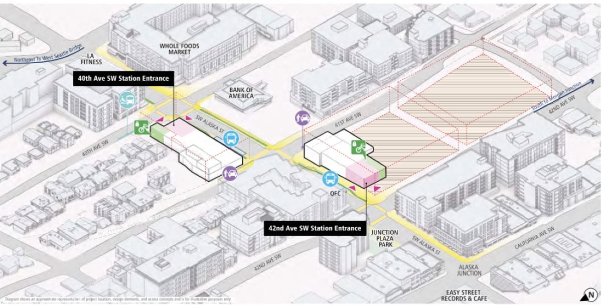
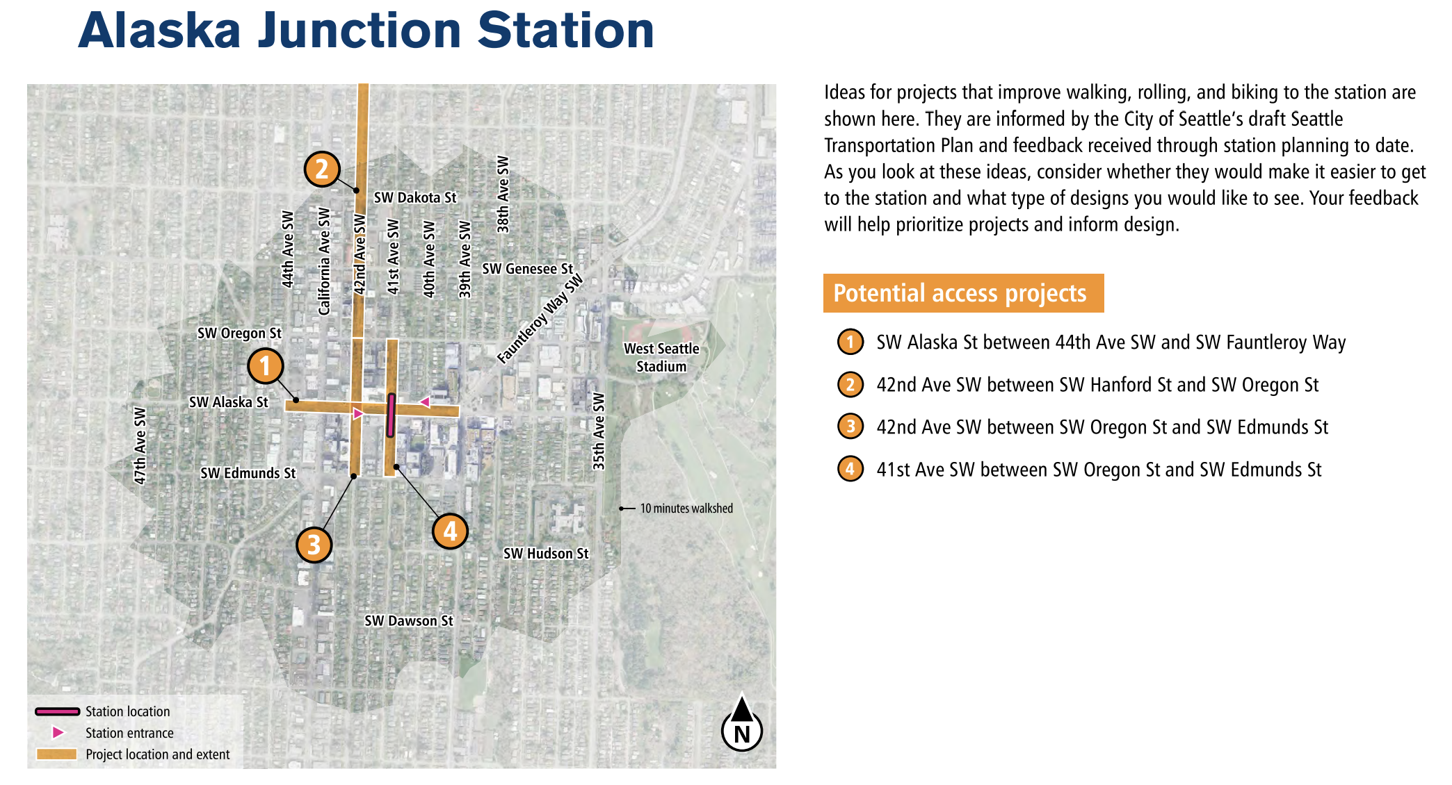
Alaska Junction Station would be the southern terminus of the 3 Line — though further expansions could extend toward Burien and the airport in the future. The station would be centered on 41st Avenue SW and SW Alaska Street with a center platform angled north-south. Sound Transit is contemplating two station entrances, one each on the north and south side of SW Alaska Street. The respective entrances would serve 42nd Avenue SW and 40th Avenue SW.
Along the SW Alaska Street frontages, Sound Transit has suggested expanded sidewalks and locating station-oriented bus bays in the street like other Seattle stations. Designated pick-up and drop-off zones would be located off the arterial street on 41st Avenue SW and paratransit is planned on 40th Avenue SW. Station headhouses would provide rider information, ticket vending, escalators and elevators as well as some built-in bike storage areas.
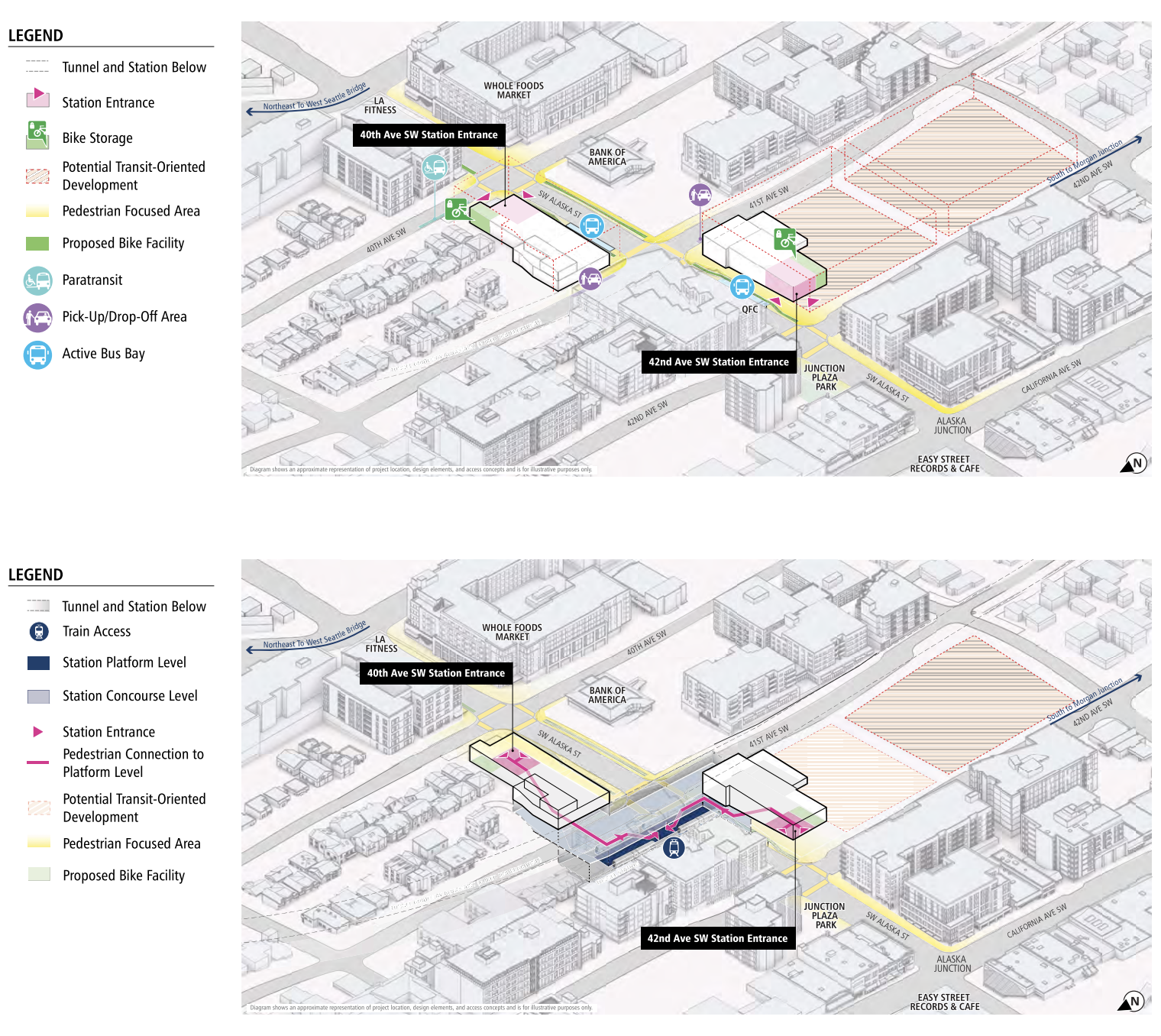
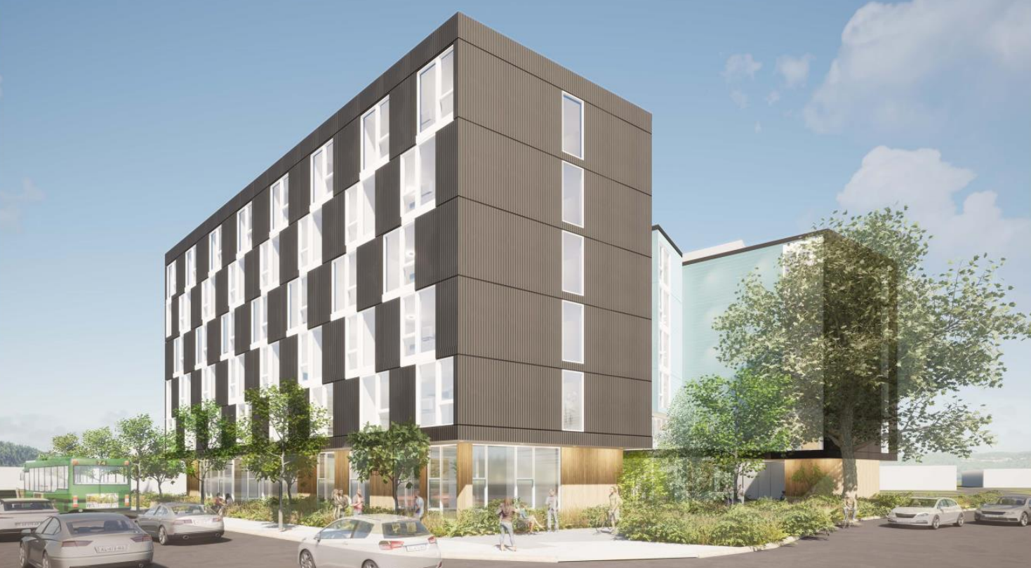
As part of the station project, Sound Transit could end up with a substantial amount of surplus property on two blocks south of SW Alaska Street between 42nd Avenue SW and 41st Avenue SW. That would require displacing a mix of apartments, retailers, institutions, and a grocery store. The agency is evaluating potential transit-oriented development that would follow there, with staging and construction sites replacing some relatively new buildings. At this juncture, the agency assumes height limits to be around 75 feet, allowing for seven-story mixed-use buildings with the potential for housing, office, social services, and retail.
The headhouse on the north side of SW Alaska Street would have a much smaller footprint (eliminating mostly drive-through businesses), but could potentially facilitate similar uses. Zoning in the area could change in the future, potentially as part of a wider station area rezone and planning process.
Sound Transit has also identified potential corridors for improved walking, rolling, and biking facilities. Those mostly stretch several blocks in each direction from the station on 41st Avenue SW, 42nd Avenue SW, and SW Alaska Street. The agency is proposing wider sidewalks, protected bike lanes, better lighting, and other streetscape improvements on SW Alaska Street. As for the other streets, Sound Transit is suggesting an extension and enhancement of a neighborhood greenway on 42nd Avenue SW as well as major pedestrian-oriented improvements to 41st Avenue SW, such as wide sidewalks, curb bulbs, landscaping and seating, and flexible spaces.
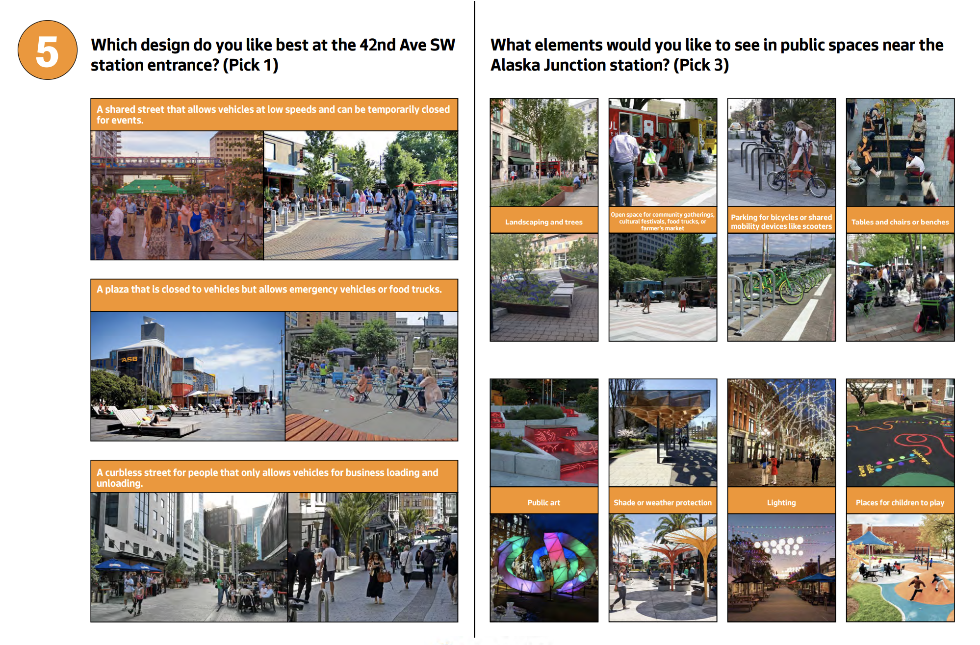
Sound Transit is seeking feedback on what station entrance spaces should look and feel like for the Alaska Junction station. The agency pitched three different ideas for the 42nd Avenue SW station entrance: fronting on a shared street with low speeds (festival street), fronting on a plaza that can be activated, or fronting on a pedestrian street. The agency is considering a variety of amenities within public spaces near the station.
Avalon station area planning
Avalon Station would be partially underground as it transitions the corridor from fully underground to trench and then elevated. The station would be centered on Fauntleroy Way SW and 35th Avenue SW with two station entrances. The main headhouse would be a triangle parcel of land and offer the ability for a larger plaza and station facilities. Bus bays would mostly be located around this parcel whereas the southern headhouse would feature paratransit and pick-up/drop-off zones. Both headhouses would offer normal station accoutrements, but bike storage might be consolidated to the southern headhouse. The station would also feature center platforms.
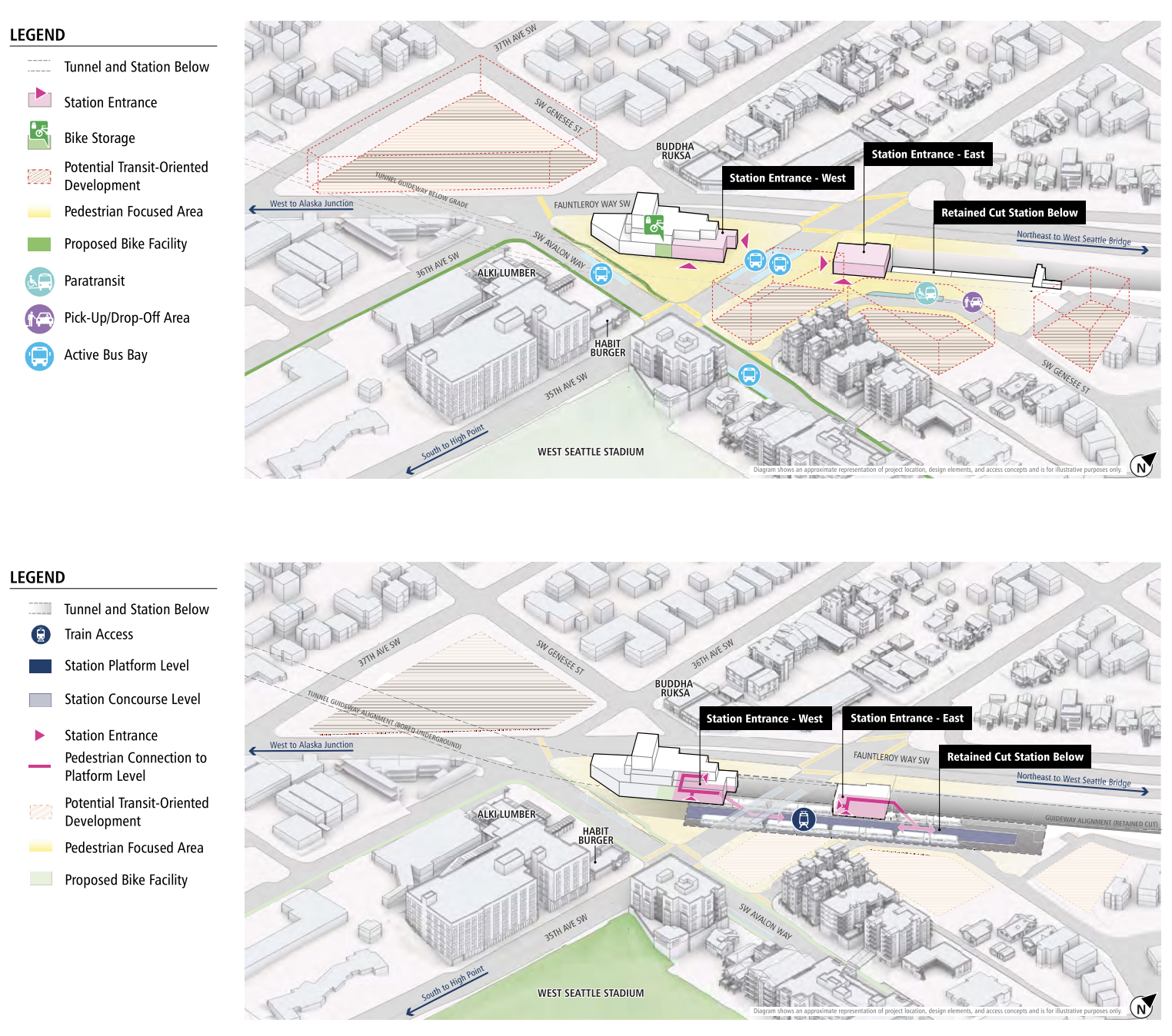
Several parcels of land could become sites for transit-oriented development, including a large triangle block west of Fauntleroy Way SW and several smaller sites east of the northern headhouse. Currently, Sound Transit envisions 75-foot tall buildings with similar types of uses as Alaska Junction. The parcels today mostly consist of strip commercial uses, but there are some low-density residential uses on them, too.
The agency plans to focus station access improvements on 36th Avenue SW, Fauntleroy Way SW, and SW Alaska Street. Sound Transit is proposing upgraded bike lanes on SW Alaska Street, neighborhood greenway enhancements on 36th Avenue SW, and a mix of traffic calming, wider sidewalks, protected bike lanes, and crossing improvements for Fauntleroy Way SW.
Delridge station area planning
Delridge Station would be elevated with a center platform and look more like a suburban station. The station location has been hotly contested as the planning process has moved forward with some earlier iterations placing the station in a more central location, but it appears slated to essentially be pushed up next to a steel plant and West Seattle’s elevated freeway. This would necessitate displacing a number of businesses and institutions.
Most station amenities would be located under the elevation platforms and guideway, but Sound Transit has drafted plans for bike storage in an accessory building. Bus bays would be scattered about on Delridge Way SW and near the station entrance on SW Charlestown Street.
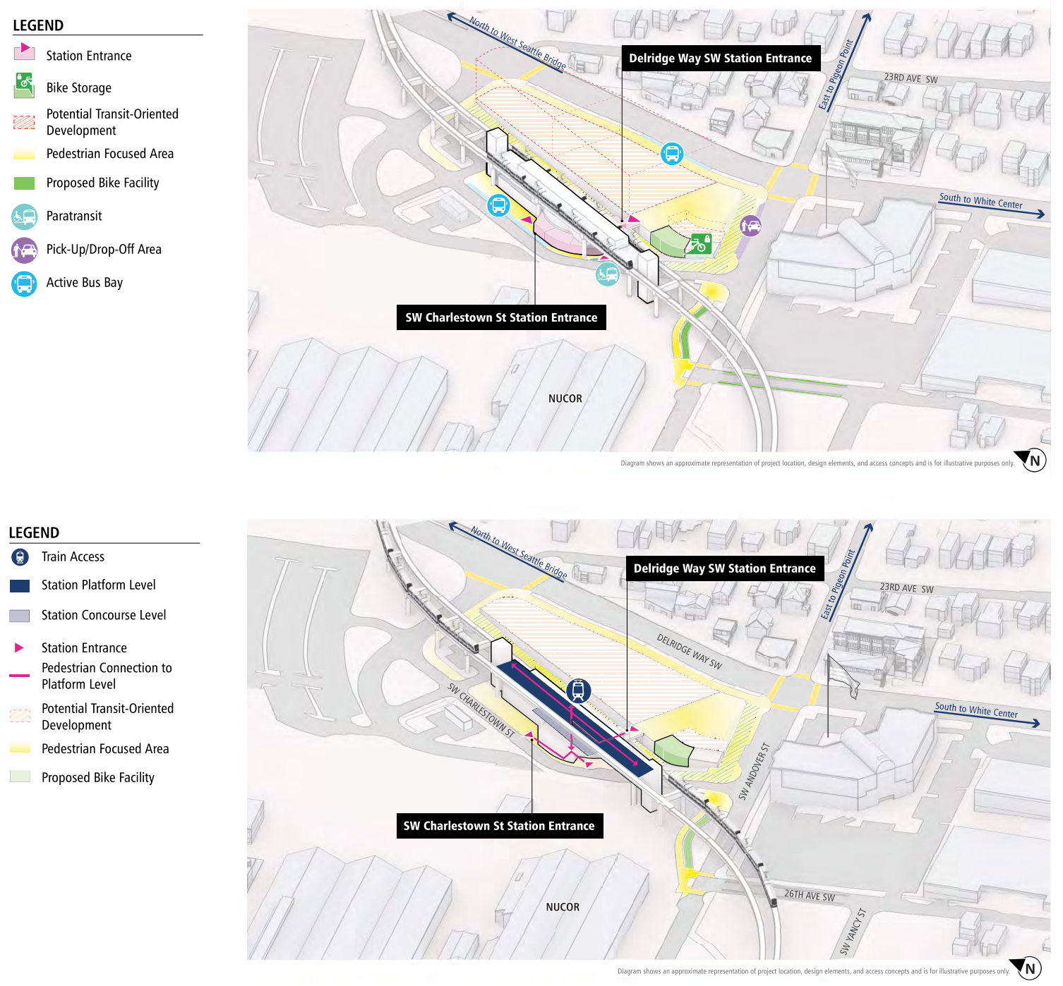
As part of the station project, Sound Transit thinks that two blocks worth of transit-oriented development might be possible. Some of this space could give way to a public plaza on SW Andover Street with some pedestrian-oriented services and retail fronting onto it. The agency is suggesting that the remaining land could feature two big projects up to 85 feet in height with similar uses as Alaska Junction.
Access improvements in the area could be smattered throughout on blocks within a half-mile of the station and south of West Seattle’s elevated freeway. Proposed projects nearest the station would upgrade the existing neighborhood greenway on 26th Avenue SW, implement traffic calming and pedestrian priority on SW Andover Street, improve walking and biking over Longfellow Creek on SW Yancy Street, and provide safe access to the Alki Trail.
SoDo station area planning
Finally, SoDo Station would essentially be expanded to accommodate an extra platform and provide vertical circulation within the station complex. As a consequence, the at-grade station would have three platforms and be served by both the 1 and 3 Lines. Expansion of the station would mostly happen within the existing SoDo busway right-of-way. A major project investment outside the station would be conversion of S Lander Street from an at-grade street to an overpass, which would allow trains to pass under the street without conflict and improve safety for all road users.
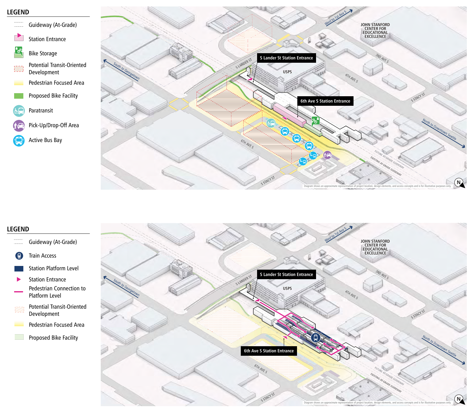
The station would have two main entrances with one on S Lander Street and another oriented toward 6th Avenue S. The latter could have some pedestrian-oriented spaces front it. The expanded station, however, could mean impacts to adjacent private property to facilitate a bus bay and paratransit loop toward the east. The 6th Avenue S station entrance would also incorporate a bike storage area.
Sound Transit has tabbed three potential SoDo station sites for transit-oriented development with two of those directly between the busway and 6th Avenue S and a third on the southeast corner of S Lander Street and 4th Avenue S. The agency believes that 85-foot tall buildings might be possible on the sites with industrial, technology, incubator, and retail uses. Additionally, only one off-site station access project has been identified by Sound Transit with the agency proposing improved and expanded sidewalks on S Lander Street between 6th Avenue S and Airport Way S.
While it is still possible that the Sound Transit Board of Directors could pick different station locations, the preferred ones that the agency has been doing station planning around mostly seem shoe-ins. Making the most of these stations will be critical since the agency projects ridership to be fairly low at around 28,000 daily riders for a $4 billion, four-mile project. Residential growth and access improvements near the stations may ultimately allow the agency to exceed those projections.
Riders and community members interested in improving station concepts and station area amenities can still offer feedback through an online survey.
Sound Transit Can’t Deliver Planned ST3 Service Levels Without Major Changes