On Tuesday, the Seattle City Council approved a targeted upzone intended to create space for about 1,000 homes in a makers district in industrial Georgetown. The changes allow an additional 10 feet of building height along a seven-block stretch centered on 4th Avenue S, totaling about 9.7 acres of land.
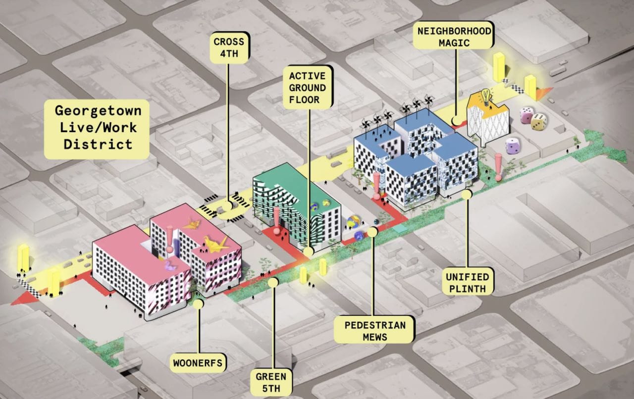
An organization called Watershed Community Development (formerly known as the Georgetown Community Development Authority) is seeking to create a large mixed-use development community in the area on land that it owns. They’re calling it the “Georgetown Live/Work District” in what could span eight or more larger scale buildings. A district master plan was published late 2021 detailing the concepts for community spaces, maker spaces, and housing space nestled in between a busy industrial area.
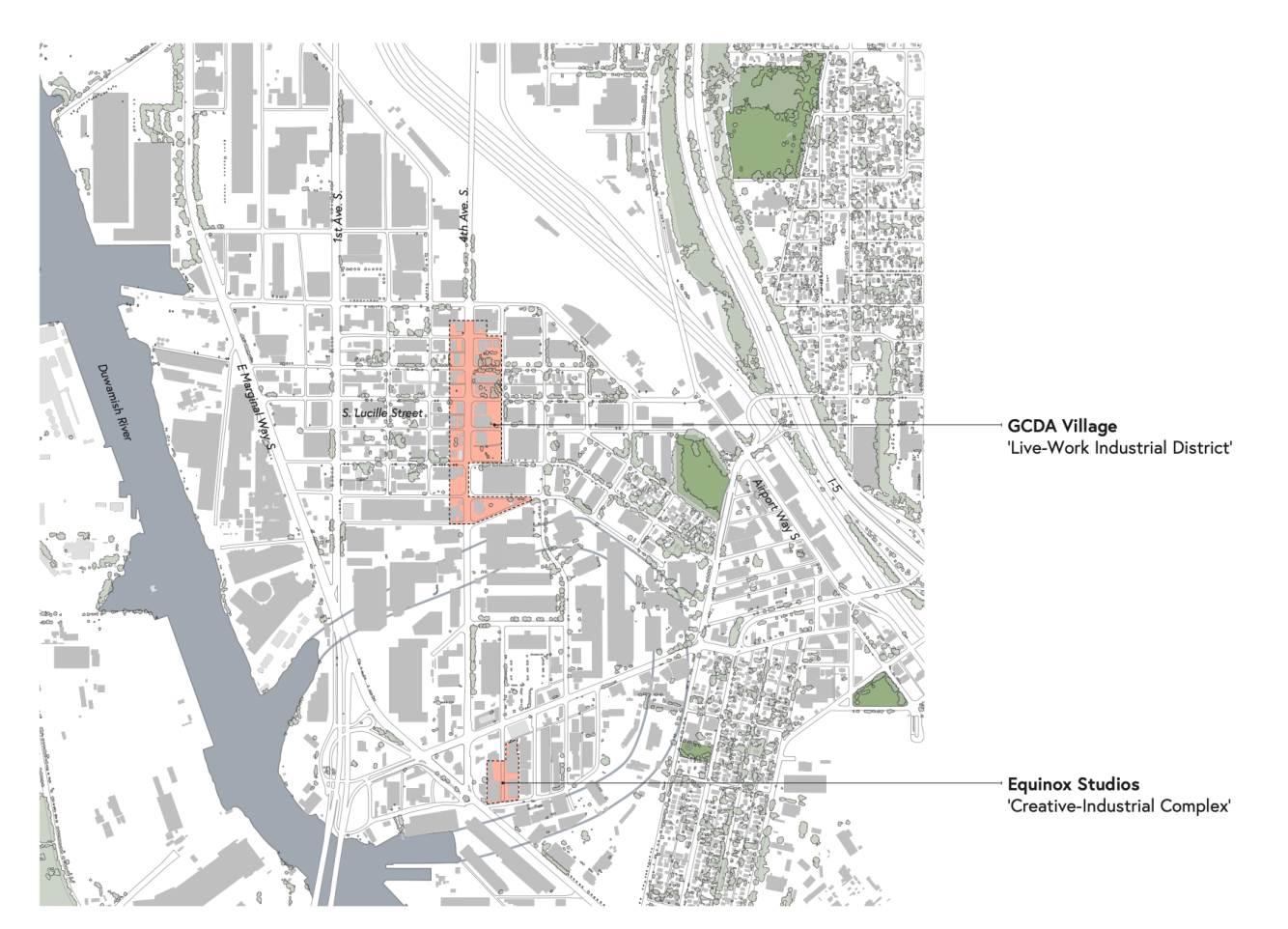
With the area on the blocks east and west of 4th Avenue S between S Dawson Street and S Fidalgo Street, the district is separated from Georgetown’s main drag by eight industrial-length blocks give or take — about a half-mile.
In time, Watershed Community Development hopes that development on the blocks could deliver 900 to 1,000 homes, including affordable and workforce housing (many at or below 60% of area median income and homes with three bedrooms), new cultural resources, and childcare options to the community along with artisan spaces and retail.
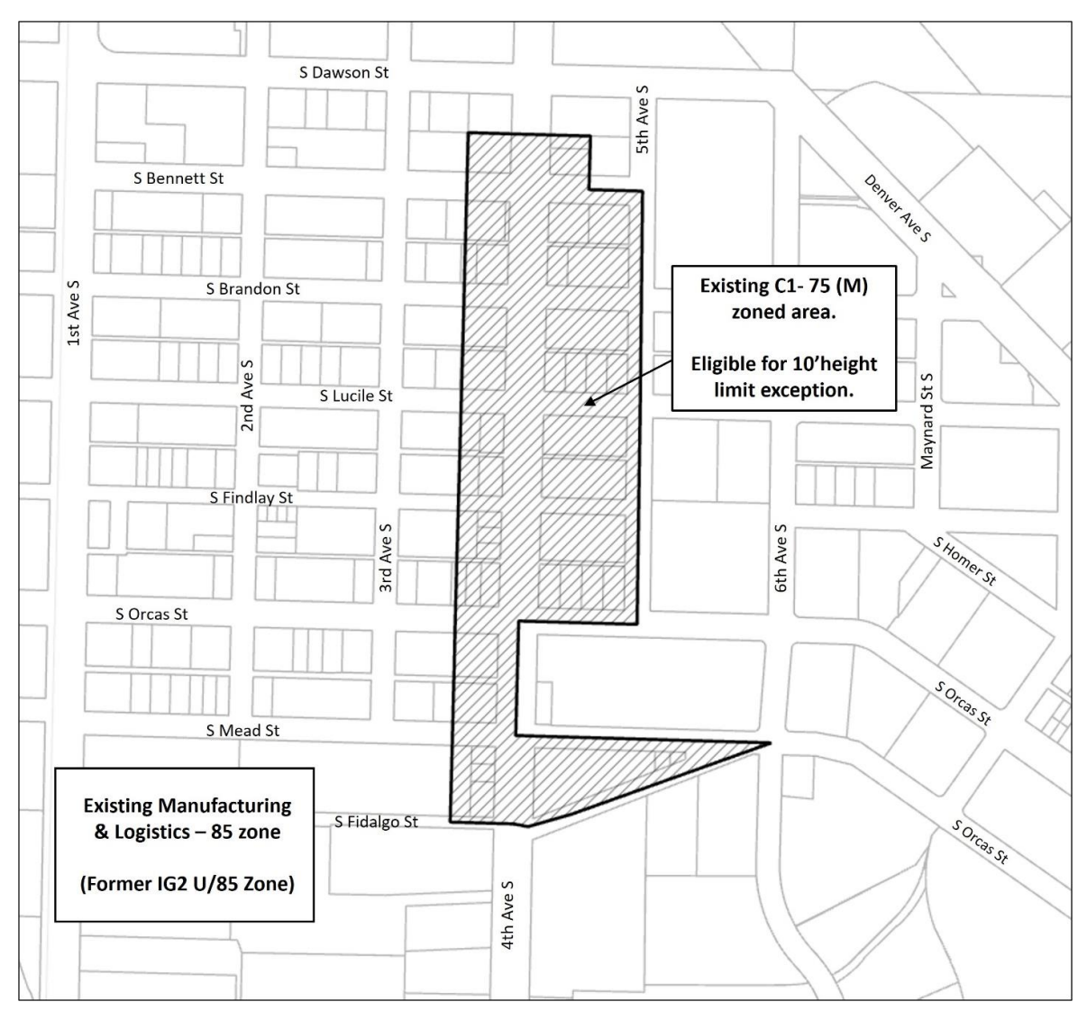
The zoning changes only apply to Commercial 1 (C1)-zoned properties. Currently regulations cap building height at 75 feet, so the zoning changes will allow buildings in the area to go to 85 feet, the same height limit that applies to some uses in the abutting industrial zones.
A report by City planners outlined some of the rationale for the higher height limit.
“The greatest number of wood-framed floors that can be constructed on top of a concrete base structure for commercial/light industrial/arts uses under the Seattle Building Code is six. With average floor to floor heights of 10 to 11 feet for residential stories, it is unlikely that a builder could construct six floors of housing in a 75-foot zone while also providing the type of tall ground floor spaces necessary to accommodate the light industrial and arts spaces desired in and around the Georgetown community,” the report states. “A height limit exception allowing an increase to 85 feet would address this by allowing a builder to maximize the amount of housing that could be built in wood framed construction and accommodate ground floor ceiling heights of approximately 20 feet.”
There are some conditions on the higher height. Councilmember Tammy Morales (District 2), who chairs the city council’s land use committee, detailed some of them in her remarks this week.
“The provisions that are required in order for developers to take advantage of the height incentive include commitment to developing a green building, at least five residential floors…, providing residential units with sound insulating windows and air cooling and ventilation systems that are designed to improve internal air quality, and dedicate at least 20% of the street-level street frontage to neighborhood-serving uses that are intended to attract and support pedestrian activity, as well as providing space with at least 20 foot ceilings for use at street level,” Morales said.
Unanimous adoption of the Georgetown zoning ordinance comes mere weeks after the city council turned down Morales’ Connected Communities pilot program, which sought to provide zoning incentives to boost affordable and workforce housing and equitable development in areas of the city that have historically been redlined, disenfranchised, and that actively sought to block non-White residents through racially restrictive covenants.
The two votes’ diverging result suggests a legislative body that could often go either way on land use issues. The 7-2 vote against the pilot program came after councilmembers raised a laundry list of concerns — some of which could have applied to the Georgetown bill but didn’t really come up.
Councilmember Cathy Moore (District 5), who had no qualms in approving the Georgetown rezone this week, laid her opposition to Morales’ legislation last month on completion of the city’s much-delayed Comprehensive Plan update while blurring the lines between policy (the Comprehensive Plan) and legislation (zoning regulations). Meanwhile, Councilmember Bob Kettle (District 7) opposed Morales’ legislation in part because of process — which spanned over two years and six deliberative city council meetings — while the Georgetown legislation was only subject to two short deliberative city council meetings.
Also at odds with comments last month, Councilmember Maritza Rivera (District 4) opposed Morales’ legislation because she felt that the City had too many affordable housing programs and didn’t have a strong grasp of how they all fit together. But on Tuesday, she supported this new de facto affordable housing incentive provision.
Rivera seemed to base her justification for this industrial-area rezone on the local context, as she understood it.
“[T]his height provision brings this particular section of Georgetown up to the same height standards or… allowances as the buildings surrounding this area,” Maritza said. “So really, the buildings surrounding are already at this height allowance and so this brings this particular area up to that height allowance as well.”
Buildings in the area, however, generally are only in the one- to two-story range as it stands. (Side note: It may not be a bad idea to start getting comfortable with the idea of a seven-story building next to a two-story building.)
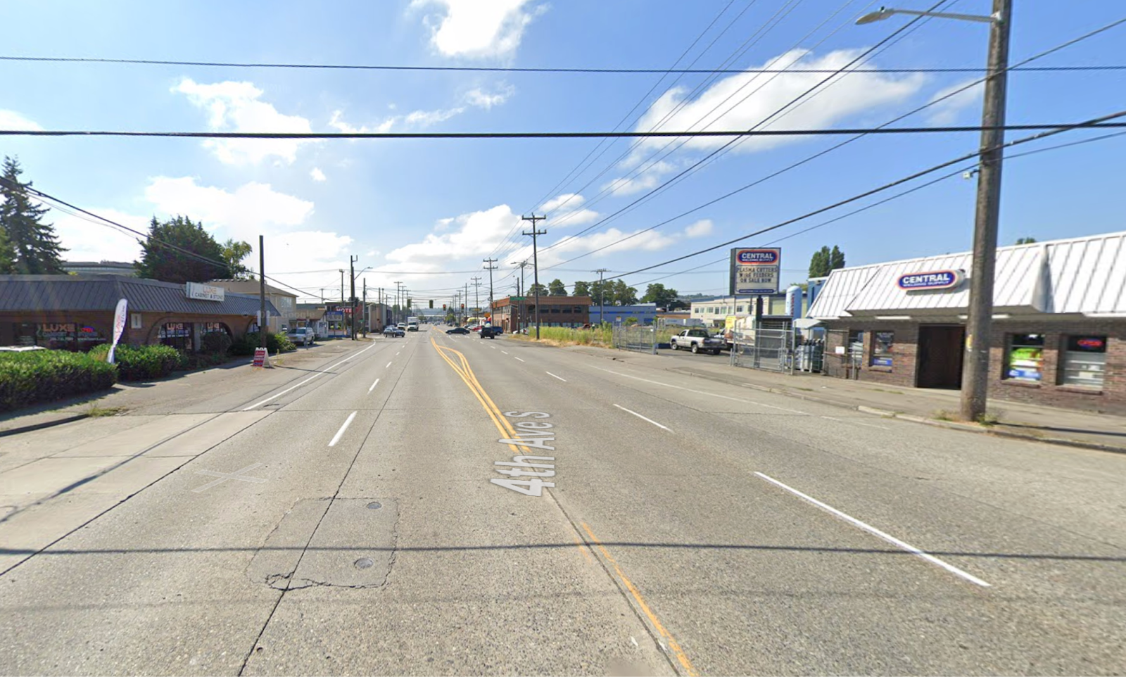
A big sticking point for redevelopment in the area is 4th Avenue S itself, which is a major trucking route with substandard sidewalks and streetscaping. Designed for speed, the street generally consists of four wide travel lanes plus turn pockets at intersections and often sidewalk-level on-street parking lanes; crosswalks are far and few between. Correcting this unsafe environment for people walking, rolling, and biking will require significant changes — potentially requiring the City to stand up to a change-adverse Freight Advisory Board and their allies at the Port of Seattle.
While overhauling 4th Avenue S is a tall task, the rewards would be significant; with a safe street grid, the potential is skyhigh for Watershed Community Development’s vision of workforce housing and makers district in Georgetown.
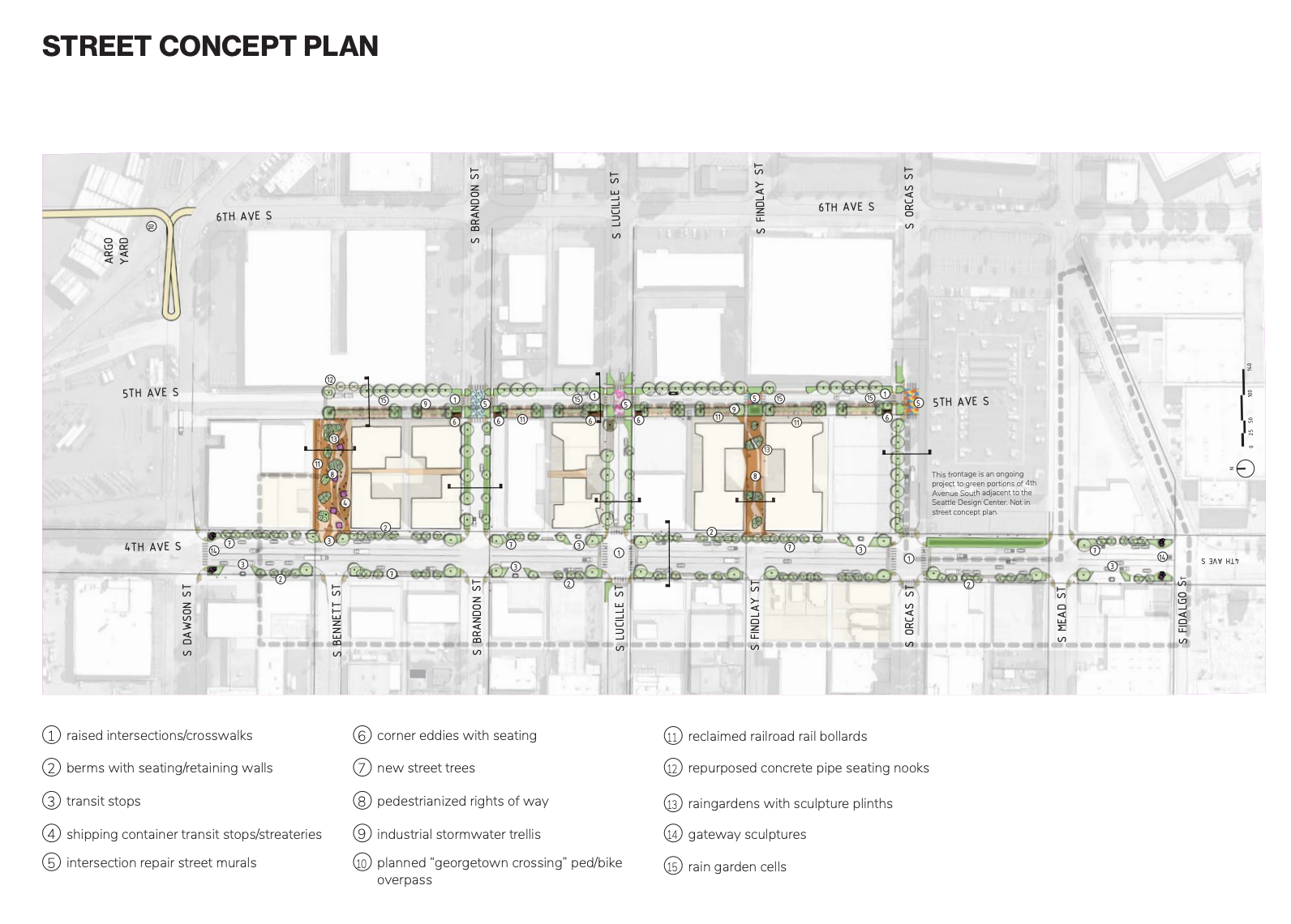
Seeming to recognize the likely freight interest opposition, Watershed Community Development has put out street concept plans that focus on street improvements east of 4th Avenue S, including some highly pedestrian-oriented east-west streets that rarely or never see freight activity. On 4th Avenue S, the concept plans essentially retain the same truck-oriented paradigm but with some targeted curb bulbs at intersections, planter strip enhancements, and removal of turn pockets.
The newly adopted Seattle Transportation Plan is mostly concerned with repairing and building new sidewalks along 4th Avenue S and making limited improvements to the street for safer pedestrian crossings. Transit enhancements may also come, supporting King County Metro Routes 131 and 132 that travel the corridor between Burien (via Highland Park and South Park) and Downtown Seattle.