

The climate benefits of urban neighborhoods, all for the low price of letting people live where they want.
Through the first decades of this century, the greater Seattle area had a secret weapon for fighting climate change: it let people choose to live closer to each other.
Using a study of neighborhood-level carbon emissions, Sightline estimates that new residents to the Seattle area produced about 5% less greenhouse gases from 2000 to 2020. That’s simply thanks to their metro area being better than any other in the United States at adding homes to existing neighborhoods.
The region eliminated about 1 million tons of potential greenhouse gas emissions basically for free: no government spending, no tax credits for efficiency, no carbon trading market, no carbon tax. This public benefit came just from reducing red tape and letting construction workers build the kinds of homes that people want to live in.
Key Takeaways
- By letting new homes locate in existing neighborhoods, the Seattle metro stopped some new and existing residents from being forced out of them.
- This trend reduced those new residents’ climate impact, since people who live farther from each other tend to emit more greenhouse gases than people who live closer together.
- Sightline estimates that new residents emitted 5 percent less greenhouse gases than they would have if they had lived in more sprawling neighborhoods.
- This climate benefit, approximately equivalent to electrifying two-thirds of the cars in the City of Seattle, did not require a large government investment.
Building those homes created jobs. Letting people live in them created economic growth, more location choices, and lower energy bills. The metro might have done even better, of course, if it had allowed more homes throughout the region; and it can keep improving in the future.
But for the economy of greater Seattle, this category of climate action has been better than a free lunch. It’s been a lunch the region got paid to eat.
Living closer to neighbors saves energy
In general, it’s a simple relationship: when people live close enough together, they use less energy and emit less greenhouse gases. Take it from the United Nations Intergovernmental Panel on Climate Change: “compact and resource-efficient urban growth through co-location of higher residential and job densities, mixed land use, and transit-oriented development (TOD) could reduce GHG emissions between 23% and 26% by 2050 compared to the business-as-usual scenario.”
This effect comes from three main factors: less driving, more energy-efficient buildings, and less displacement of nearby ecosystems by energy-intensive objects like pavement.
1. Lower transportation emissions
Cars and trucks are the leading source of greenhouse gas emissions in most states and provinces. Residents of the most compact neighborhoods—areas of apartments mixed with workplaces and shops, whether in cities or suburbs — drive much less than residents of spread-out neighborhoods of detached houses on large lots. “Infill housing reduces pollution by reducing driving,” as UC Berkeley’s Terner Center for Housing Innovation puts it.
A Terner Center study finds that San Franciscans emit less than a third as much carbon from transportation as residents of the sprawling Bay Area exurb of Oakley, while making a similar number of trips for the same purposes. Another found that households in California’s suburban, single-detached neighborhoods drive more than twice as much every weekday as households in urban neighborhoods with high transit usage. And public transit usage increases with population density (among other factors). In places where few people live close enough to walk to the bus stop, transit can even be less climate-friendly than personal automobiles.
These emissions benefits also accrue to existing residents of a neighborhood that adds people, not just new residents moving in. When there are enough people in your neighborhood to support a grocery store or a new bus line, now you get to walk to the grocery store or take the bus to work instead of driving.
2. More energy-efficient homes
There’s no better insulation than another entire climate-controlled home on the other side of your wall. Urban neighborhoods are much more likely to have such wall-sharing multifamily housing, which one study finds uses 35% less energy for heating and 21% less energy for cooling than equivalent households in single-detached houses. (What’s more, multifamily homes generally have smaller floorplans, which further reduce energy consumption from heating and cooling.)
3. Preserving—not paving over—carbon-sink ecosystems
It takes energy to make stuff, and spread-out cities require more stuff. One researcher at Delft University of Technology found that “urban sprawl accounts for a third of all greenhouse gas emissions” via increased raw materials in construction, less efficient land use, and higher consumption of goods and services. Sprawl also replaces previous land uses that can sequester carbon, while infill adds homes without destroying these vital carbon sinks: forests, wetlands, grasslands, farmland, and others.
A tale of two ZIP codes
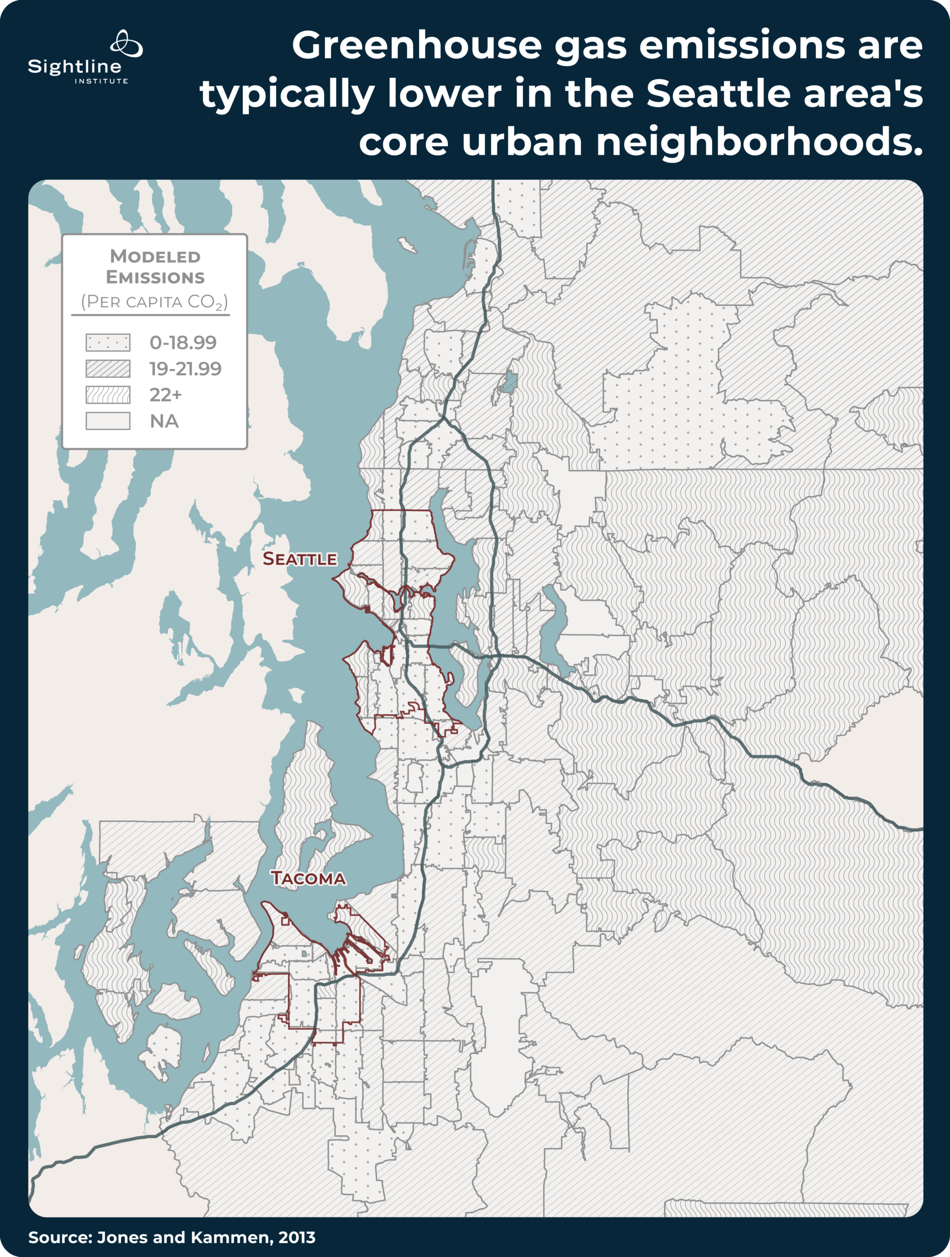
Consider some (hypothetical) denizens of two different neighborhoods around the metro: Beth, a resident in Seattle’s Beacon Hill neighborhood, which features lots of apartments, local shops, and services, and is comparatively transit-rich; and Maria, a typical resident in the suburb of Mercer Island, which has mostly large, single-detached houses on large lots and a single commercial center on its north end best accessed by car. According to a 2014 study from UC Berkeley, Beacon Hill Beth emits 16.75 tons of greenhouse gases in a year, while Mercer Island Maria emits 25.05 tons of greenhouse gases annually — almost 50% more than that of her counterpart across Lake Washington.
Why such a big difference? According to the researchers, Maria used more electricity and natural gas, drove more, and consumed more goods and services than did Beth.
As the Seattle metro grows its population, one key for reducing carbon emissions is figuring out how to make adding a newcomer look more like adding a Beth than like adding a Maria. And the high home prices and rents in places like Beacon Hill show, via basic market supply-and-demand principles, that plenty more Beths would love to live there if they could — i.e., if there were more homes they could afford there.
In general, the metro’s more populous urban neighborhoods are full of Beths (the dotted regions below, clustered along the I-5 spine), and its less populous suburban neighborhoods are full of Marias (the wavy regions below, often along the water or east of Lake Sammamish). Over the last 25 years, strategies like the city of Seattle’s urban villages plan and other upzones across the region have channeled new residents into existing urban neighborhoods instead of sprouting new exurbs at the edge of the metro.
What was the climate impact of all those new people living where they ended up? To know that, you’d have to make an educated guess about what would have happened if Seattle had sprawled even more instead of growing inwards as much as it did.
If this were medical research, scientists might want to study twins separated at birth. It turns out that the Seattle metro has a twin whose similar origin but different destiny helps us imagine a hypothetical, more sprawling Seattle. It’s Dallas.
Everything’s bigger in Texas, especially the suburbs
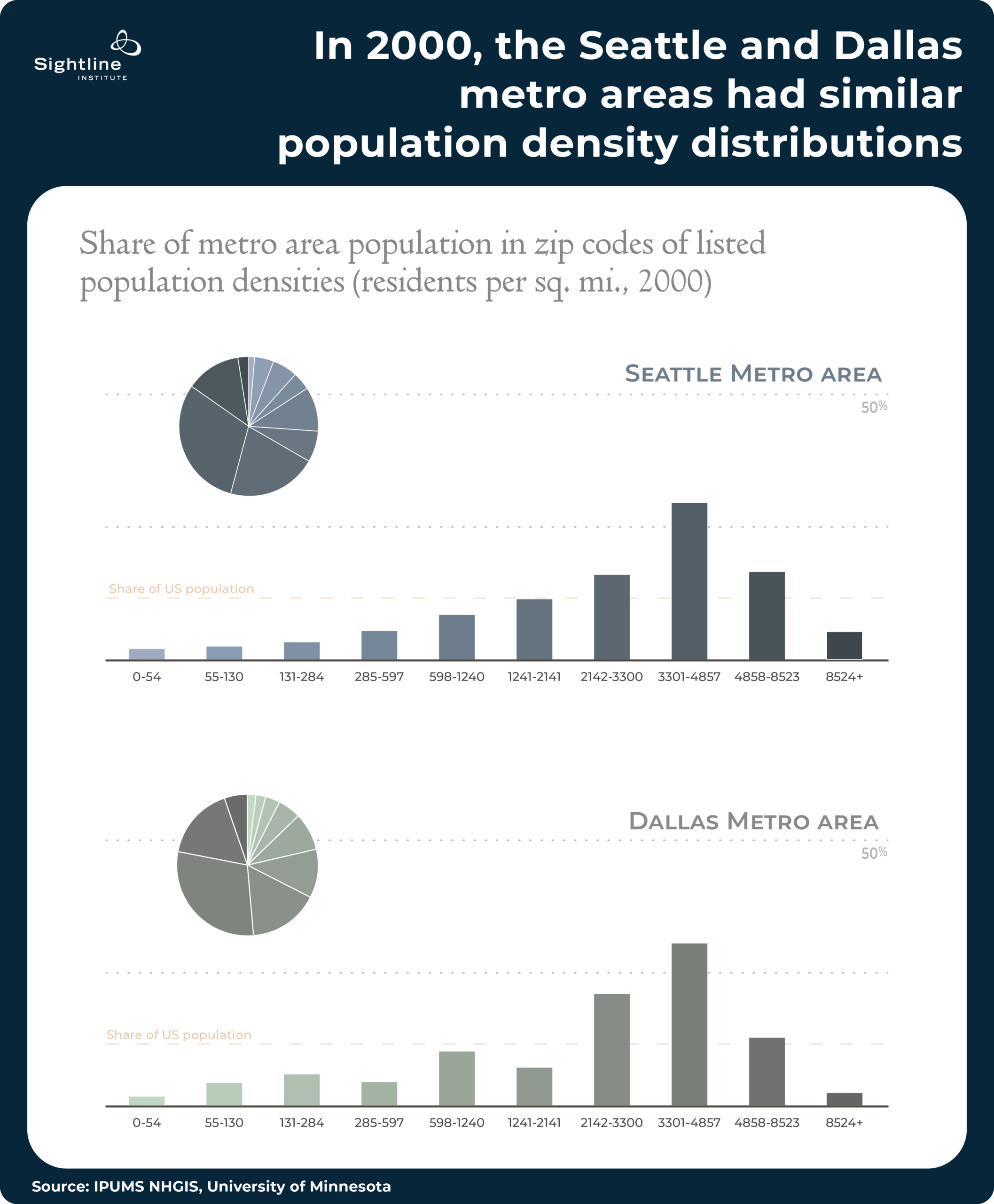
In 2000, the Seattle and Dallas metro areas were very different in the popular imagination: a tech hub of fleecy outdoors enthusiasts and an oil boomtown of truck-driving football fans.
In one way, though, they were unexpected siblings. Their populations were spread across the land in similar patterns. Specifically, if you parceled out their populations into buckets based on how close they lived to each other — their population density or concentration — and made a chart, you’d see almost the same shape. In both cases, the follow patterns emerge:
- Few residents lived in low-population density neighborhoods characteristic of more rural parts of the United States (picture a Vashon Island-like spread of detached homes separated by acres of farms and forests);
- Lots of residents lived above the median U.S. population density (picture something closer to Bothell, a mix of smaller-lot homes, duplexes, and scattered low-rise apartments); and
- A handful of people lived in neighborhoods with higher population density than just about anywhere in the country (picture Seattle’s U District, with larger apartment buildings along major corridors and plenty of small-lot multiplexes elsewhere).
Over the next 20 years, however, the two metros took different paths. Seattle added new residents across neighborhoods of all types, with both new neighborhoods and old neighborhoods growing a modest amount. Dallas, meanwhile, saw booming growth in its least populous neighborhoods, sprawl beyond the prior footprint of the metro, and a loss of residents from its most populous neighborhoods.
Hundreds of thousands of people in Dallas now live in neighborhoods that were farmland and open space as recently as the early 2000s, while already built-up neighborhoods have barely changed to accommodate the new babies, families, and workers arriving in the area. When new residents do manage to arrive in old neighborhoods across the Dallas metro, they usually replace existing residents rather than growing the neighborhood: existing residents either pass away, move out to a new exurban subdivision, or leave the region entirely.
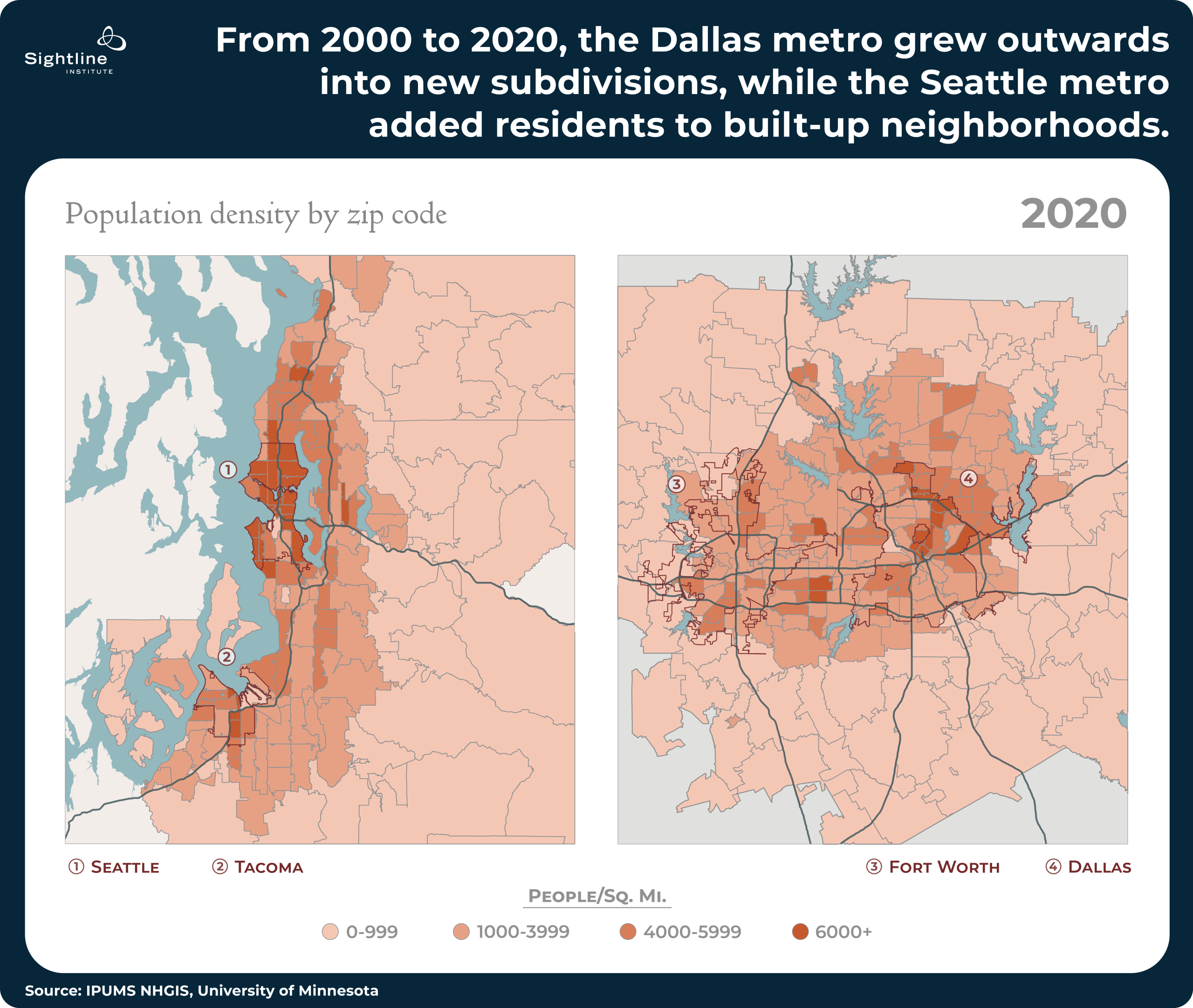
Dallas, then, offers Seattle a useful what-if. The two metros started at around the same place in 2000 but diverged by 2020: Dallas went out. Seattle went up.
Imagining a Texas-style Seattle — and its emissions
Imagine a more Dallas-like Seattle since 2000: Seattle’s metro area grew just as fast as in real life but followed Dallas’s outward pattern. No downtown highrises in Bellevue or Seattle. No reinvention of South Lake Union as an urban hotspot. No walkable town center in Kirkland or Redmond. No spinal cord of eight-story apartment buildings along arterial streets. No three-story walkups near suburban transit stations. No explosion of mother-in-law apartments, backyard cottages, and townhomes.


Now compare the carbon emissions of real Seattle and Dallas-style Seattle using the same Berkeley study of ZIP code-level emissions estimates, to get a back-of-the-envelope idea of the scale of Seattle’s specific growth pattern on Seattle’s specific emissions level. The main assumption: that additional residents of a neighborhood would, on average, emit the same as their neighbors.
Think of it like this, with Beacon Hill Beth and Mercer Island Maria from earlier. Say that Beacon Hill gained 100 new Beths (on net) between 2000 and 2020. At 16.75 tons of carbon emissions per capita, that’s 1,675 extra tons of greenhouse gases compared to 2000. But if instead, in Texas fashion, Mercer Island gained 100 Marias, the town would have emitted an additional 2,505 tons of carbon — far more than if those residents had gotten to live in Beacon Hill.
Like all research on the climate impact of where people live, Sightline’s analysis has its own assumptions, shortfalls, and caveats. Relying on a one-time snapshot of emissions disentangles population changes from other factors that change over time, but it also ignores how changes in population density would themselves affect per-capita emissions. Keeping the total metro population constant avoids conflating increased emissions with increased population, but it also essentially assumes that infill patterns don’t affect the number of people migrating from one metro to another, only location choices within each metro.
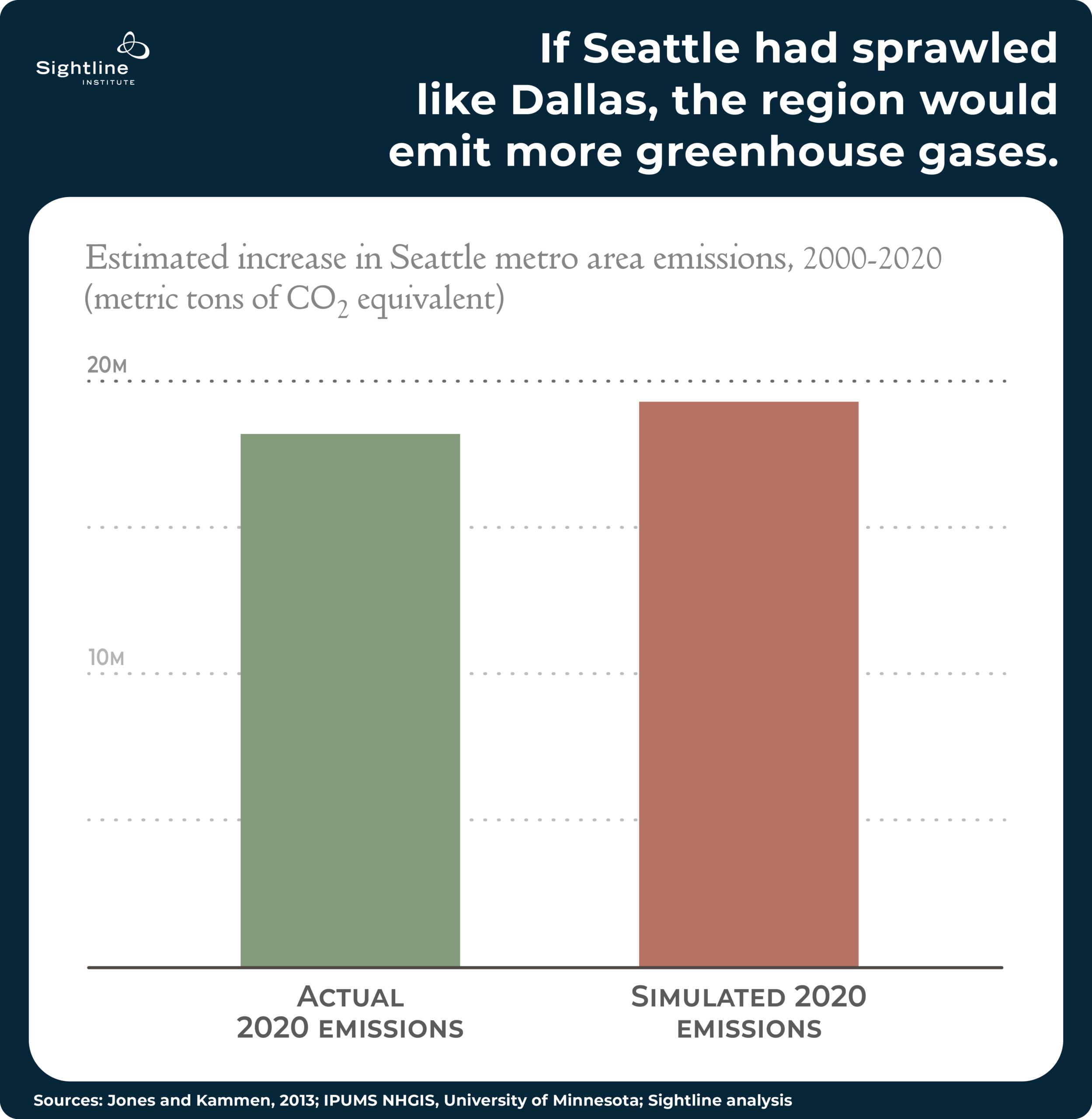
The question here: How much carbon do Seattleites save by being unusually good at welcoming more neighbors? The best answer Sightline can offer: about a million tons a year.
The benefit: Like electrifying two-thirds of Seattle’s cars
Sightline’s analysis of the Berkeley ZIP code emissions model estimates that by 2020, the Seattle metro area’s slightly less-sprawling growth since 2000 was keeping 1 million tons of greenhouse gases out of the atmosphere every year, compared with what Seattleites would have been emitting if they had sprawled like Dallas. The region’s additional residents are 5% more energy-efficient than otherwise, due entirely to where they chose (and could choose) to live.
This happened on top of all the other climate action from people and governments in the Seattle area, from subsidizing solar panels to composting eggshells to weatherizing old buildings. And this happened essentially for free! A million tons of greenhouse gases is as much as you would save in a year by switching over 315,000 cars from gasoline to electric, or more than two out of every three cars in the city of Seattle.
As Sightline explains in a report on the Seattle metro area’s best-in-the-U.S. success at urban population growth over this period, the star of this show was the city of Seattle itself. In other infilling metro areas, like San Jose, suburban jurisdictions led the way on adding residents to existing neighborhoods. But here in the middle of Cascadia, Seattle proper was the standout performer. The average Seattle resident emits 6% less greenhouse gases than the average resident of the rest of the metro area, so every person who gets to move to (or stay in) the city instead of the suburbs shaves off about one ton of their annual carbon emissions. That’s even more than they would save by skipping a solo road trip to Dallas every year.
These findings reflect actual, real-world behavior by millions of people. Claims about immense emissions reductions often depend on immense uptake: “if every gas-powered car were replaced with an electric car,” “if the population density of a city doubled,” “if the meat substitute industry were substituted for the meat industry.” And indeed, if every Mercer Island Maria turned into a Beacon Hill Beth, we might expect emissions to drop by much more.
But in real life, where the Seattle metro added a handful of Beths to the mix instead of going all-in on more Marias like Dallas did, a 5% savings is a win worth celebrating. For the city of Seattle, which led the way, every additional resident who didn’t have to move to Woodinville is a mini climate victory.
Just one piece of the puzzle
While this ZIP code model is a useful tool for estimating neighborhood-level emissions, it still excludes what actual emissions in the Seattle metro look like over time, which likely tell an even rosier story. In addition to the population distribution changes described here, other trends like less driving, more electric vehicle adoption, and energy efficiency upgrades are also reducing greenhouse gas emissions across the region.
Letting people live closer to each other connects communities, improves transportation options, and makes homes less expensive. To that, we can add that it fights climate change. Quite the list.
For those of us in and around Seattle, a bonus: though we can still do more to welcome new neighbors to our blocks, we can boast that to date, we’ve been doing it better than anyone else in the country. And it’s paying off.
Author’s note: Thanks to Good Measures for graphic design, CORE GIS for mapping, and Zack Subin for feedback on an early draft.
This is a crosspot that first appeared at the Sightline Institute. Find audio versions of Sightline articles on any of your favorite podcast platforms, including Spotify, YouTube, and Apple.
Jay Lee
Jay Lee is a Researcher with Sightline Institute, where he works to advance electoral upgrades across Cascadia, analyze demographic trends and climate migration patterns, and support his fellow researchers with quantitative analysis. He holds a BA in mathematics from Reed College. In his personal life, Jay enjoys riding his bike around town, playing squash, and crushing it at trivia night. After several years in Portland, Oregon, he now lives in New York City. Email him at jay@sightline.org, and follow him on Bluesky or LinkedIn.