Article Note: This is the second part of a two part series by Alex Brennan on Seattle 2035 growth alternatives. In this article, Alex discusses what an Alternative 5 should look like. The Urbanist Editorial Board will issue an endorsement on the topic tomorrow that follows in the spirit of Alex’s proposal.
On Friday, I penned an article on the history of Seattle’s comprehensive planning efforts and evaluated all four growth alternatives proposed by the City as part of the Seattle 2035 comprehensive plan update. In my estimation, each of the four alternatives presented have significant inequities in them that could be addressed by another alternative. This second articles suggest a fifth alternative that better meets the City’s race and social equity and environmental criteria.
To recap a bit, what would an equitable Alternative 5 look like? I expect that many low income communities targeted for new or expanded urban villages in Alternatives 3 and 4 will want to protect their neighborhoods by advocating for Alternative 2, which on the surface looks like it has less displacement impact. However, as I argued in Part 1, Alternative 2 means high housing prices and more urban renewal like growth in the limited areas where growth is allowed. That’s not an equitable strategy. Dispersion is good for equity. Rather than retreating from the expansion of urban village boundaries (as Alternative 2 does), an equitable alternative would further expand the boundaries and spread out growth into more middle class and wealthy neighborhoods. We need more development to keep prices down, but we also need it to happen in less concentrated doses and we need it to be less focused in vulnerable communities where it is replacing our limited stock of low cost housing and can lead to displacement.
Putting new urban villages near recent transit investments (as Alternatives 3 and 4 do) is a good thing. More people should be able to enjoy the benefits of those investments. The problem is only putting new urban villages in those locations. On its own, proximity to recent transit investments (light rail and RapidRide) is a flawed framework because it concentrates growth in those most vulnerable communities while preventing low-density wealthy neighborhoods from ever developing the neighborhood centers that can support walking, biking and transit. So what would be a better framework?
A Not So New Framework for Adding Urban Villages
A better approach would supplement Alternative 4 by ensuring every part of the city is within walking distance of an urban village. Everyone should have a neighborhood business district they can walk to–a dense, mixed-use place with street life, stores, and restaurants. Every part of the city should be within walking distance of low cost housing types like rowhouses and small apartment buildings to foster economic diversity. Every part of the city should be within walking distance of a neighborhood business district with jobs so at least some people can walk to work. Every part of the city should be within walking distance of a growing neighborhood center that can support great transit service. Adding urban villages in these new areas relieves pressure on the working class urban villages, makes our wealthy neighborhoods more accessible, and provides the environmental benefits of more walkable, transit supportive communities.
This approach is essentially the Urban Village strategy Seattle created in 1994. Most of the city is within walking distance of an urban village—we just left out a few places. Now let’s add them back in. Welcome to Alternative 5 (trumpets play).
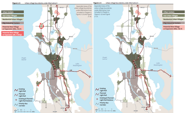
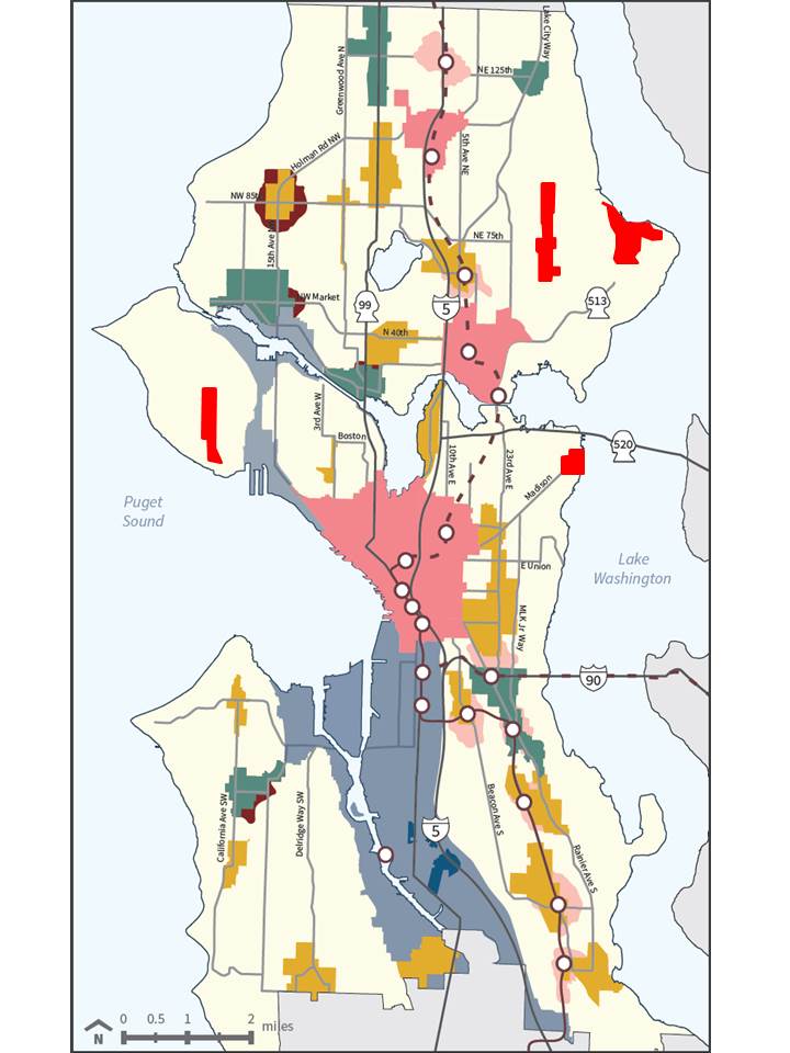
What were the most egregious omissions in 1994? That would be almost all of Northeast Seattle, along with Magnolia and Madison Park. The graphic below shows the ½ mile walksheds—as the crow flies—for the existing urban villages alongside the displacement index map from the City’s equity analysis. These three areas circled in orange—Northeast Seattle, Magnolia, and Madison Park—pop out on both maps as being outside the urban village walksheds and having very low displacement risk.
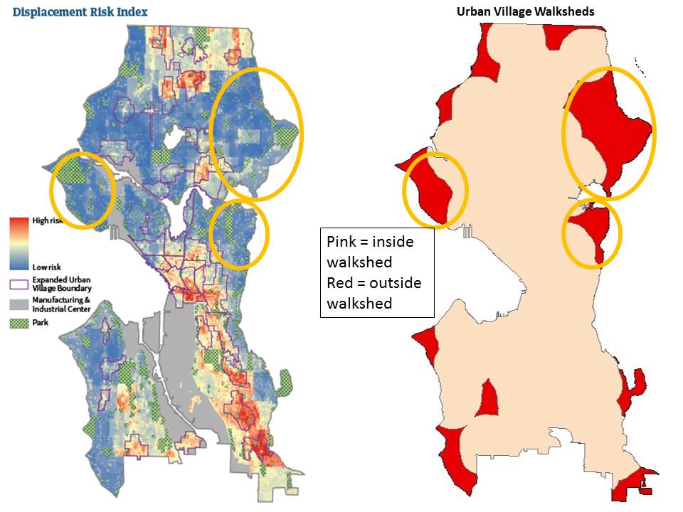
There are a few other areas in red on the periphery of the city (and Delridge), but these three areas stand out for their size and proximity to downtown. Magnolia and Madison Park would appear larger on a more precise walkshed map because they are separated from the nearest urban villages by steep hills, bodies of water, train tracks (for Magnolia), and gated communities (for Madison Park). All three areas are significantly wealthier and whiter than the city as a whole and generally have less diversity in housing types (except Madison Park) as shown in the table below.

Northeast Seattle
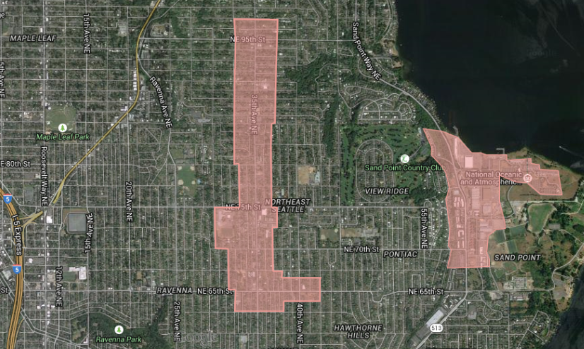
Let’s start with Northeast Seattle, the biggest of the three areas, spanning the neighborhoods of Bryant, Wedgwood, Laurelhurst, Windermere, View Ridge, and Sand Point. From the University District to Lake City, there are no urban villages to the east. As shown above, these neighborhoods together are home to over 36,000 people. It’s an exclusive area with median household income at $100,129 (compared to $65,277 citywide) and a racial make up of 80% white (compared to 67% citywide). About 20% of the households make over $200,000 a year, and in Laurelhurst, that number rises to 34%. Explaining this disparity (and thanks to the lack of an urban village) single-family, detached homes make up 76% of the housing units compared to 45% citywide. Despite the low densities and lack of frequent transit service, only 58% of residents drive alone to work compared to 52% for city as a whole. This indicates that the biggest alternative transportation challenge is for trips like shopping and meeting up with friends, the kind of trips that could be helped more by a better neighborhood business district than by increased transit service.
Is there a good place to locate an urban village in Northeast Seattle? Yes! Two good candidates stand out.
The most obvious is 35th Ave NE from about NE 65th St to NE 95th St (right by my childhood elementary school). While this central strip through Wedgwood remains very auto-oriented, it has good street grid bones and a host of destinations from the northeast library, to major grocery stores, houses of worship, and a smattering of other shops and places to eat mixed in with trees, surface parking lots, and tiny houses. Eckstein Middle School is right there, too. 35th Ave NE and NE 65th St may even soon become a high frequency transit node as part of Metro’s University Link restructure. Such a long, skinny Urban Village would not be unprecedented. The Phinney Ridge-Greenwood Urban Village similarly follows Phinney and Greenwood Avenues from 65th to 90th Streets.
The Wedgwood Urban Village described above is a start, but providing good coverage for all of Northeast Seattle requires a second urban village further east. The area around Magnuson Park is probably the best candidate. The former military buildings on the north end of the park have been repurposed bringing employment and a variety of facilities and services including almost 500,000 square feet of office space for the National Oceanic and Atmospheric Administration’s Western Regional Center. Low-income housing has also been built there and more is coming bringing a low-car ownership population to the area. However, there are almost no stores for these workers and low-income residents to walk to. Each sector feels isolated and not part of an urban fabric. Urban village designation could be the beginning of a strategy to knit Magnuson Park with the neighborhood on the other side of Sand Point Way and add more neighborhood serving retail.
Magnolia
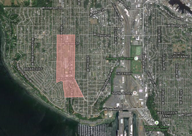
Magnolia is actually closer to Downtown Seattle than the West Seattle Junction and could have a similar type of urban village. However, it is currently one of the most isolated and exclusive neighborhoods in the city. As noted in the table above, over 12,000 people currently live in Magnolia. 88% of them are white and the median household income reaches $112,301; 24% percent of households make over $200,000 per year. The housing make up of Magnolia is 84% single-family detached units. The southern half of the peninsula boasts even more extreme demographics with a median household income of $147,765, a 99.6% housing share of single-family detached units, and a racial breakdown of 90% white. Meanwhile, 60% of employed residents report that they drive alone to work. As with Northeast Seattle, this rate is not much higher than the city average.
Magnolia has almost no retail or basic services. Building up a neighborhood business district would be a long-term project. Despite its limited stature, the area around the Magnolia Community Center is the obvious location for a new urban village. Located in the geographic center of the neighborhood, these few blocks also contain two schools, a playfield, library, a smattering of multi-family housing, and a cluster of stores and restaurants around W McGraw St and 32nd Ave W.
Madison Park
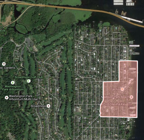
The final urban village addition would be Madison Park. This neighborhood is in many ways a mirror image of Magnolia. Fronting on Lake Washington instead of the Puget Sound, close to Downtown but isolated, incredibly wealthy (median household income $106,908) and white (87%), Madison Park is home to Seattle’s only consistently Republican-voting electoral precinct (the gated community of Broadmoor). The one main difference is housing types. Madison Park is home to two large residential towers of the Park Shore Retirement Community, which knock its single-family detached housing percentage down to 47%, although these retirees do not show up in the commute data, 65% of employed residents drive to work alone. These residential towers, and the cluster of stores next to them, could lay the foundation for the final urban village addition. The Seattle Department of Transportation is currently looking at a new bus rapid transit line on Madison St, but Madison Park itself does not have the ridership to support extending the line all the way to the lake today. A new urban village here could eventually change that dynamic allowing for a future extension of the line.
Adding Wedgwood, Sand Point, Magnolia and Madison Park as Urban Villages helps these neighborhoods become more urban, walkable, economically diverse places. However, I want to emphasize again that the equity impacts are broader. As the original 1994 Urban Villages start to fill up, adding wealthy parts of the city to the urban village mix helps take pressure off the working class neighborhoods in the Rainier Valley and elsewhere already under consideration for expansion. Alternative 5’s broader set of urban villages can be part of a comprehensive arsenal of mitigation strategies (discussed in Part 1 and in the City’s equity analysis) that can make growth in working class neighborhoods more equitable.
Fear of Traffic
Why would we not want to add these urban villages? Why were they not included in previous alternatives? Discarding the notion that exclusive enclaves should remain exclusive to retain their neighborhood character, I think the main objection to Alternative 5 rests on fear that these neighborhoods have inadequate infrastructure—mainly in the form of transportation. Seattle has a fear of adding density before adding transit, which is ultimately a fear of traffic. We have horrible traffic and no one wants to make it worse. Won’t adding density before adding transit make traffic worse? Isn’t that how we got ourselves into this traffic mess in the first place?
A traditional level of service traffic analysis will certainly tell you that adding more density will make traffic worse, but level of service analyses are shown to be highly inaccurate in urban settings and are starting to be rejected as a methodology for measuring development impacts. If you recall the density-vehicle miles traveled charts from Part 1, vehicle miles traveled per capita goes down as density goes up. Beyond that, there are three reasons why I think the traffic impacts will not be that bad.
First, Seattle suffers from what Eric Eidlin calls dense sprawl. Like Los Angeles, much of our region is too dense for free flowing car traffic, but has a dearth of places dense enough to support transit, walking, biking, and proximate trips. Making the transition from dense sprawl to urban neighborhoods is what the Urban Village strategy is all about. The suburban retrofit is another way to talk about this transition.
Second, proximity and walkability are often just as good as transit service at traffic reduction. Urban villages do not just add density; they add the things that a neighborhood needs to be a neighborhood. Right now if you live in Magnolia and you want to try a new restaurant, go to the movies, or get your nails done, you have to get in your car and drive (or take a circuitous bus ride if it’s even an option) to some other neighborhood that has such things because there is no local urban village option that’s a short walk away. This is less true for commute trips (rush hour bus service to downtown is decent and Magnolia’s Urban Village probably wouldn’t have a lot of jobs for the foreseeable future), but, as mentioned earlier, commute trips aren’t Magnolia’s problem. An overemphasis on commute trips blinds us to the benefits of proximity and walkability. Research is growing that “walkable urbanism” is more important for reducing car trips than “transit-oriented development.”
Third, this is a gradual process. Imagine in a couple of years that NE 35th Ave gets a few new apartment buildings with ground floor retail. Is the traffic bad yet? It gets a few more and a small office building to boot. How about now? Is the traffic really bad now? Part of the whole goal of spreading development to more parts of the city is that every neighborhood gets a more gradual growth experience with more opportunity for adjustments and accommodations. There should be time to see traffic problems as they develop and address them before they become problematic. These neighborhoods do have some transit service already and that service can get gradually better as the neighborhood grows.
Other Considerations
For people that want a transit-oriented city there is a political factor to keep in mind as well.
Providing the transit first assumes that the density will come afterwards. However, many our transit station areas have sat without development for years, partly because of the recession, but mostly because zoning restrictions were not lifted. When you let the density happen first, you know it will be there to support the transit service that is eventually added.
While more transit doesn’t make changing zoning politically easier, more density does make adding transit service and transit (and walking and biking) priority easier. If SDOT had told people 10 years ago that it was going to make two lanes on Westlake Avenue transit-only because that was the only way to accommodate all the growth that was planned for South Lake Union, most people would have been confused if not furious at the inconvenience. Won’t taking away lanes make traffic worse? Now that the growth has arrived, the lane decision seems obvious and overdue with even the Seattle Times acknowledging that turning car lanes over to transit is “by far the most cost-effective way to move more people through a congested city.”
For people that want an equitable and inclusive city, it’s also important to keep the traffic problem in perspective. Is the risk of a few years of bad traffic in a few wealthy neighborhoods really an excuse for focusing development in ways that exacerbate our affordability crisis and displace poor people and people of color from our city?