In yesterday’s article, I went over some of the characteristics of I-5 in Downtown Seattle and offered some temporary solutions for mitigating the effects of the freeway. In this final installment, I will summarize my recommendations for each phase, propose a number of themes, and provide information on how you can get involved to make this project happen.
Design Guidelines
Synthesizing all of the information in the case studies, the site analysis, and the history of I-5 resulted in a set of general themes and specific design guidelines for each lid section. The guidelines take the form of both strict parameters and suggested features that should be considered by designers, elected officials, and the public. However, a more detailed technical review and rigorous public process will be needed before developing an official plan for the area.
A key theme is facilitating neighborhood connections that have been severed for over half a century. The break in the street wall between Downtown and Capitol Hill is a jarring experience for people walking between the two. There is a long pause between any chance of finding welcoming, human-scale places where spontaneous socializing and commerce can happen. Freeway noise, rivers of cars, and exposure to the elements make pedestrians feel vulnerable and isolated. Bringing new low-scale buildings, awnings, trees, and cozy public spaces to the street edges will provide cohesion between neighborhoods and heal the urban scar left by I-5.
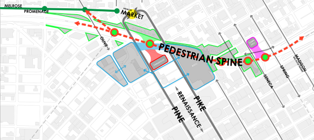
Another theme is the “pedestrian spine”. This concept envisions a unified walking experience throughout the series of lids between Madison Street and Olive Way. This spine should have consistent design elements and accessibility, including wide paths, mid-block crosswalks, and, as previously suggested, new ramps for accessing Freeway Park. Such a path would work well both for people walking and people bicycling. The spine theme works in concert with the “emerald chain”: because the lids will be built in phases, each must be an independent park space. Each emerald should shine on its own but work with its neighbors as they are built later on.
What follows is a summary for each lid section in the order they should be developed:
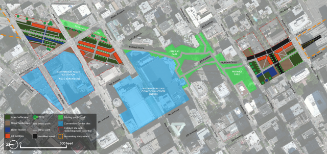
- Section 2A (east side of the Pike Street/Boren Avenue intersection, 0.3 acres): This lid section should be built first because it is small, it can serve as a prototype for the other sections, and it will be timely with the Washington State Convention Center (WSCC) expansion across the intersection. It can also integrate with the existing Plymouth Pillars Park adjacent to the freeway. Design suggestions include a small plaza, a performance pavilion, and an extension of the neighboring dog park. The intersection itself should be raised to prioritize non-motorized traffic.
- Section 6 (Madison Street to Spring Street, 1.5 acres): The Spring Street on-ramp must be removed to build a full lid that is flush with the surrounding streets (the alternate ramp is six blocks away at James Street). This lid should primarily be a park space, but retail buildings would be appropriate on the east side to preserve a southerly view towards Mount Rainier and activate 7th Avenue. A combination of hardscapes and softscapes can provide a large, versatile event space. Crosswalks and sidewalks are needed on the four sides where they are missing.
- Section 5 (Spring Street to Seneca Street, 1.5 acres): The Seneca Street off-ramp will need to be removed to create a more useable and pedestrian-friendly park surface, along with more space for retail buildings (the alternate ramps are at James Street and Madison Street). This section will also need to integrate with the Naramore Fountain on 6th Avenue. Another major design opportunity is to punch through Freeway Park’s old planter boxes on the south side of Seneca Street and transition into a flatter and more useable space on the new lid.
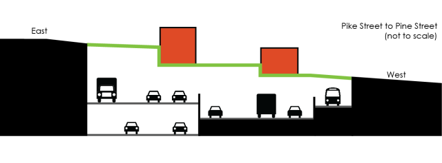
- Section 3 (Pike Street to Pine Street, 2.5 acres): This lid may may become the crown jewel. It should be developed to fit into the Pike-Pine retail corridor and connect to the WSCC facilities on either end of it. A pedestrian shopping street is envisioned down its length (see the rendering at the top of this article), with terraced lawns and roof decks along the periphery taking advantage of the slope. A staircase between the Paramount Theatre and Plymouth Pillars Park could create a new pedestrian route away from busy streets. This lid has the potential to attract a wide array of visitors while also becoming a new place for Capitol Hill residents to relax and socialize.
- Section 1 (Olive Way to Pine Street, 2.6 acres): This area is the the largest and so should be developed last. The steeper slope here is best negotiated with a terraced surface that can be designed with a tight weave of ramps and stairs from top to bottom, facilitating more passive activities and providing a more relaxing park environment. Any commercial activities should be limited to the top tier of the park, which will have a commanding view to the west and which can connect to existing development on the east side of the freeway.
The recommended areas for lidding total 8.4 acres, resulting in the earlier cost estimate of $250 million. This bites a significant chunk out of the Center City’s 13-acre open space deficit.
The rest of the study areas are not recommended for lid development:
- Sections 4A and 4B (Freeway Park gaps, total of 1.5 acres): These two gaps in Freeway Park’s coverage should not be developed. Freeway Park has significant historical value in its original design, and it provides a view of the unique University Street ramp and the curving freeway mainline below. More practically, the gaps can likely provide natural tunnel ventilation, negating the need for some of the costly and space-consuming mechanical equipment that may otherwise be needed throughout the study area.
- Section 2B (west side of the Pine Street/Boren Avenue intersection, 0.1 acres): This area is not a lid candidate because the WSCC expansion will cantilever over the freeway at this location. The latest design iteration proposes retail space and building entries at this corner, which will be a positive change from what is an otherwise desolate pedestrian experience.

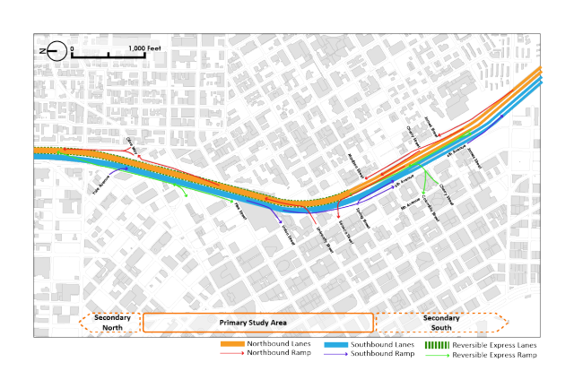
- Secondary north (Olive Way to Denny Way, 4.2 acres) and Secondary south (Madison Street to Yesler Way, 15.5 acres): These secondary areas should only be considered for lidding after the primary study areas are fully developed. They are not in a trench that is easily covered, with retaining walls only on the eastern side. In the south a portion of the freeway is also elevated above city streets. If lids were built with open colonnades on the downhill side, the environmental impacts would be substantial. Underneath Freeway Park, for instance, the traffic noise reaches a deafening 85 decibels. Solid walls would be necessary, essentially creating a concrete case. This is likely a costlier proposition that would present little visual improvement unless other measures, like embedding private development into the side of the case, were implemented. But with all of this said, these two areas are quite large and could support a wide variety of park features and private development in the more distant future.
Moving Forward
People live in cities for the access to other people, jobs, shopping, entertainment, and events that only urban environments can foster. Over the past century, that environment has been threatened by a concerted effort to focus less on natural and efficient means of access (that is, walking, bicycling, and transit), and instead make cities more accessible by private automobile. Compared to the rest of North America, Seattle has actually been relatively spared from the most dramatic effects of auto-oriented planning. The city has even managed to stitch some of the tears in its urban fabric. But a gaping hole still remains in the heart of the city where, over 60 years ago, I-5 sliced off Downtown from the bustling Capitol Hill and First Hill neighborhoods. It’s time to close that gap and refresh the urban experience that draws people and businesses to Seattle.
The next step is to form an organization of community members to pressure the City Council and local state legislators to take charge on lid planning. Business leaders, civic figures, neighborhood advocates, and other interested groups must come together as one voice to demonstrate that the status quo is not acceptable. The organization will need to develop a common vision, expand on the interim solutions presented here, and propose an actionable long term strategy. Ultimately, it will be vital to host an open, public process and be transparent about costs and benefits. This could help avoid repeating the 1995 electoral loss of Seattle Commons, a similarly ambitious park proposal that would have made South Lake Union appear much different than it does today.
The early signs of such an movement are here. A group of design and development professionals under the name Lid I-5 started meeting in 2010 to discuss feasibility and sketch out lid concepts. However, that group is currently idle and is waiting for a political spark.
More currently, the Pike-Pine Urban Neighborhood Council meets frequently to discuss how the WSCC expansion can give back to its neighbors with good design. The topic of freeway lids has come up as part of the WSCC’s public benefit package and the group is planning to speak to the Seattle City Council at an upcoming event. On December 16th at 12pm, there will be a “lunch and learn” where members of the public can speak with the Council about lidding the freeway. I have been invited as a speaker to the event and will share details about costs and funding.
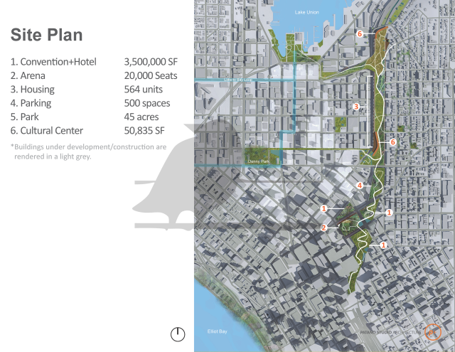
Architect Chris Patano recently proposed a two-mile long, 45-acre lid stretching north from roughly Pine Street to Lakeview Boulevard. It would be a park integrated with housing, a museum, a hotel, and the sports arena that Seattle and Tukwila are jockeying for.
I met Patano earlier this year to discuss the concept, and I find his idea bold and exciting. Of the freeway, he told KING 5, “We might as well contain it and turn it into an asset instead of a detriment”. However, his vision is much more complex than what I am proposing. Patano’s early cost estimate is $800 million ($17.7 million per acre), about four times what I estimate it would cost to lid I-5 just in the Downtown core. It’s also located where the freeway is not in a trench, an area I had in my first proposal but later withdrew because of the topographical challenges. Regardless, Patano’s renderings have successfully gained media attention and he is stirring public discussion. This should be capitalized upon to further the conversation.
Downtown Seattle and its surrounding neighborhoods are well developed and still growing even more. The time for freeway lids is now, and the price is manageable in the face of overwhelming benefits. We can create the grand central park that Seattle needs while also reducing I-5’s impact on the people, transportation, and built environment of Downtown. Seattle must seize this opportunity to transform the core of its public realm and create a lasting investment in the lives of future generations. Strong leaders are needed, but it begins with a grassroots effort. Let’s begin refining and advocating for this project today to ensure Seattle has an even brighter tomorrow.
To that end, I have created a Facebook page, an e-mail list, and a new page on my website for interested people to discuss the idea. Whether you support freeway lids now or still have some concerns, sign up to hash out ideas and get updates on this proposal. In the following months, I will be seeking partnerships with other local professionals who can provide more of the detailed financing and engineering analyses that are needed.
For a full version of my thesis on this topic, download a copy of the paper (20 MB PDF).
This article is fourth and final installment in a four-part series on lidding I-5 in Downtown Seattle. A version of this series originally appeared on The Northwest Urbanist.