The Seattle City Council will hold a public hearing on the major update to Seattle’s Comprehensive Plan. Better known as Seattle 2035, the drafted plan represents the City’s priorities covering the next 20 years. Councilmembers have had extensive discussions on the Mayor’s Recommended Plan through individual briefings across most of the standing committees. The Planning, Land Use, and Zoning (PLUZ) Committee has also held more than a half-dozen formal meetings since May. Last month, the PLUZ Committee identified 13 high level policy issues to address and provided direction on how they should be tackled.
In a meeting last week, the PLUZ Committee retraced some of their steps on amendment proposals to the Comprehensive Plan, but focused most of their attention on five primary topics, including:
- A proposed Community Involvement Element;
- Industrial lands policies;
- Possible amendments to historic preservation and cultural resources policies;
- Making technical corrections to the Neighborhood Planning Element due to inadvertent omissions of language; and
- Commercial affordability policies.
In particular, Councilmembers had robust discussions on the proposed Community Involvement Element and commercial affordability policies. Council Central Staff followed up discussion by raising some past issues that the Committee had previously been briefed on. One of the primary issues still remaining is how the Future Land Use Map (FLUM) should be addressed.
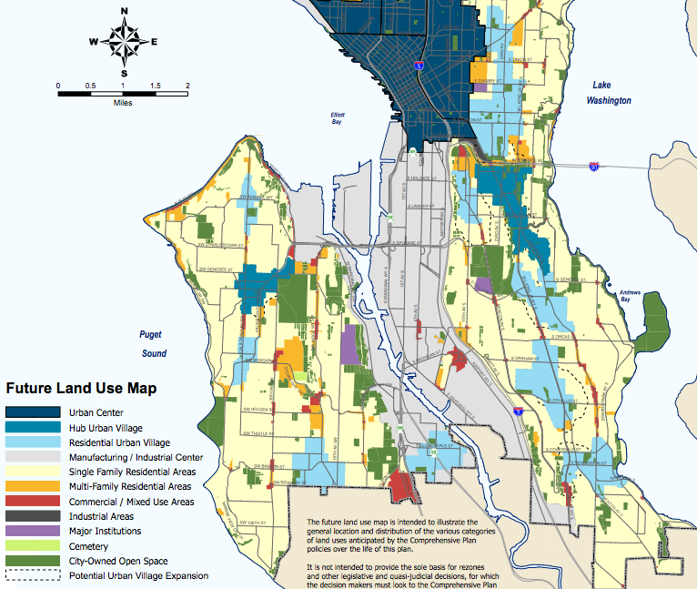
The Future Land Use Map Question
In drafting the Mayor’s Recommended Plan, the Office of Planning and Community Development (OPCD) proposed a suite of changes to the FLUM, including mapping tentative areas for urban village expansion and coloring in urban villages and urban centers. Those changes were put forward in the final version of the Mayor’s Recommended Plan, but OPCD won’t have final recommendations on where urban villages should be expanded until sometime next year, in large part because OPCD still needs to complete the process of soliciting community feedback on where to draw the lines.
The PLUZ Committee decided that it would be in the best interest of the City to not move forward with mapping fuzzy urban village expansion lines as part of Seattle 2035. Some of the reasons should be fairly apparent. For one, drawing lines now could create an expectation for property owners to be included in an urban village expansion. For another, it could fuel increased property speculation and solicit undue excitement by the public when no final decisions have been made.
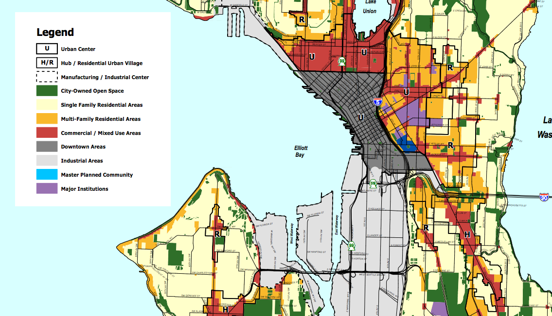
In terms of changing the colors on the FLUM, the PLUZ Committee had indicated support for only adding cemeteries as a unique land use in August. Urban villages, however, would not be “painted” in with the blue tones that OPCD had included as part of the Mayor’s Recommended Plan. This presents a significant technical challenge for the Mayor’s larger Housing Affordability and Livability Agenda (HALA) process, which is intended to include Mandatory Housing Affordability (MHA) rezones next year.
One feature of the Mayor’s HALA proposal is predicated on rezoning large swaths of land within urban villages to increase allowed building heights and floor area ratio and changing zoning district types. Some areas of urban villages are still zoned single-family residential; in those instances, zoning is intended to change to denser, more diverse zoning types like multi-family residential. Likewise, some multi-family residential zones are intended to change to commercial zones. Under the Mayor’s preferred approach, rezones are generally planned to be urban village-wide in nature as opposed to only touching certain zoning types within urban villages.
However, the existing FLUM designations of Single Family Residential Areas and Multi-Family Residential Areas in many urban villages pose an obstacle to making those sort of changes mentioned above. If the FLUM isn’t changed to “paint” the urban villages with one land use designation, fewer rezones would be possible. That’s because single-family residential zoning types are the only permissible implementing zones for Single Family Residential Areas. Likewise, multi-family residential zoning types are the only permissible implementing zones for Multi-Family Residential Areas. Changing those areas would in effect be delayed because it would require amendment to the FLUM in tandem with rezones. The likely timeframe for implementation could be somewhere between late 2017 and early 2018.
Last week, Tom Hauger, a senior planning staff member of OPCD, explained the issue to the Councilmembers in this way:
The real idea behind “painting” the urban villages was to indicate that the urban villages and the urban centers are really expected to be different places than the areas outside them. It was to show the intention that these places are likely to be the most dense places in the city and they’re also the places that we’re going to see a wider mix of uses–multi-family housing and commercial use–and in concentrations that aren’t found outside of them. They also may have an effect on future zoning changes because there will no longer be a need to change the Future Land Use Map to effect a rezone within an urban village if they’re all “painted” the same color.
Having said that, however, current policy in the Comprehensive Plan says that the colors on the map–as it exists today–are intended to be generalized areas and not specific boundaries. And that a change to the Future Land Use Map is only required if changing a large area and allowing significant change in use. And so rezones can already occur without a Future Land Use Map amendment. So the “painting” of the village doesn’t really do much in that regard, but it does signal the City’s intention more clearly how these areas are intended to be treated different.
Councilmember Johnson asked if the proposed change would result in zoning changes. Clarifying the matter, Mr. Hauger said:
It doesn’t not change any zoning directly and it’s accompanied by new policy that [is] in the Mayor’s Recommended Plan that more specifically say[s] what we’re expecting in terms of heights, scale, and density in each village type and new policy that also says that heights should taper down within the village toward the outside of the village. So, I think it gives more direction than we’ve given in the past about how we make those decisions about what occurs within the villages.
Following on, senior planner Patrice Carroll gave a little more background on why OPCD had proposed the FLUM changes in the first place:
If we leave the Future Land Use Map as it is, essentially it looks very, very similar to the Future Land Use Map we had 20 years ago. I think at this point in time, certainly a lot of the public discourse that we had during all of the outreach that we’ve been doing over four years, is that people think that the Future Land Use Map should be different and the City is actually making a shift in the policy. So that change on the Future Land Use Map says land uses within urban villages are considered very differently than land uses outside of urban villages, and I think that’s the important shift.
In concluding the discussion, both Councilmembers Rob Johnson and Lisa Herbold expressed an openness to take another look at the issue in order to better understand the ramifications of pursuing various policy paths.
Public Hearing On Thursday
The public hearing on the Comprehensive Plan will kickoff at 2pm on Thursday (September 15th). Individuals who wish to provide public testimony are advised to sign-in. The Clerk will have a sign-in sheet available as early as 1.45pm. Councilmember Rob Johnson, Chair of the PLUZ Committee, is also taking feedback directly and sharing it with his colleagues. If you have any priorities that believe the City should pursue, now is the time to share them with the City Council.