On Monday, the Seattle City Council had a full agenda of rezones cross the dais. These included three separate district rezones in the Central Area, a site-specific contract rezone at 24th Ave and E Union St, and minor zoning amendments to two areas of Belltown. The City Council also adopted new design guidelines for Mount Baker Town Center and the Pike/Pine district.
Central Area Urban Design Rezones
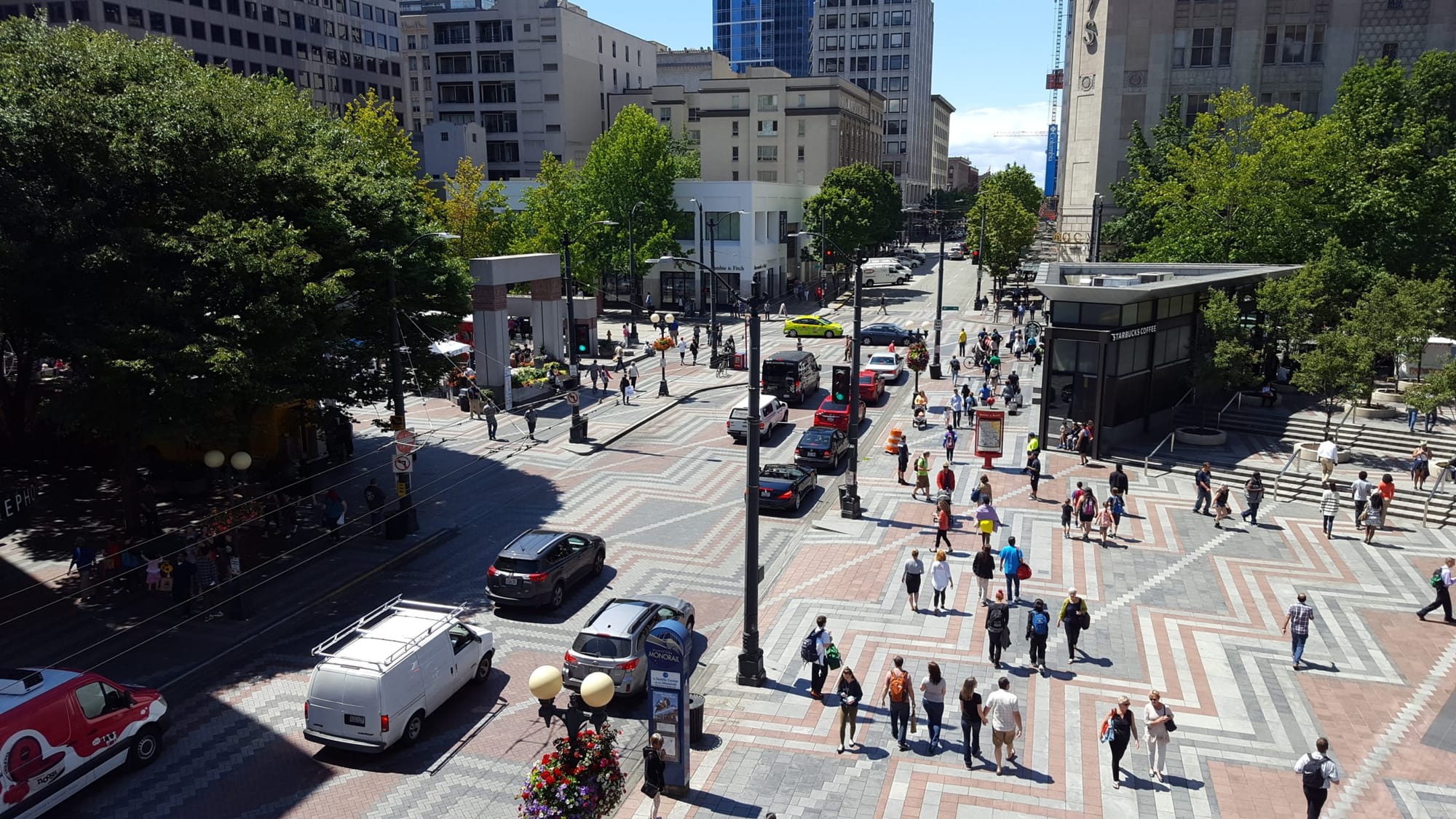
Last month, we covered the proposed Central Area rezones, which focus on enhancing urban design and increasing development capacity at three neighborhood commercial nodes on 23rd Avenue. The nodes are focused on Union Street, Cherry Street, and Jackson Street. Baked into the rezones are requirements for ground floor activity, ground floor setbacks, upper-story stepbacks, and mid-block connections. The highest new building heights allowed under the rezones are 75 feet, though the rezones run on gradient of higher development capacity in terms of overall floor area and height. Some of the rezones will unlock new uses not currently allowed, such as retail where areas zoned SF5000 and LR1 become NC1-40 (a mixed-use zone).
This slideshow requires JavaScript.
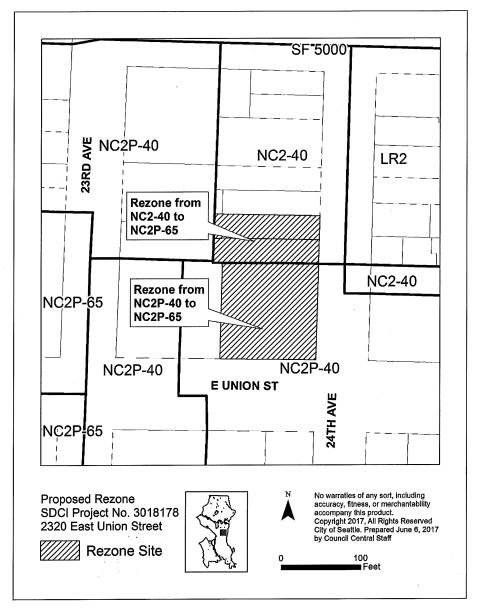
A technical correction to the rezone map for Union Street was made, which pulled out three parcels proposed to be rezoned to NC2P-75. The reason for this is that Capitol Hill Housing is seeking to construct a six-story building on the properties and was getting a contract rezone for the site to NC2P-65 during the same Council meeting anyway. The technical correction also modified a block of zoning east of 24th Ave on E Union St to include a Pedestrian designation on E Union St.
The Central Area rezones unlock mandatory housing affordability requirements for new development. Residential development will have to provide between 7% and 11% of units as affordable or pay $20.75 to $32.75 per square foot as a fee to the City for affordable housing. Commercial development will have to provide between 5% and 9% of total floor area as affordable housing or pay a fee to the City for affordable housing equal to $8 to $14.50 per square foot. As an area with high displacement risk, the requirements are considered to be in the highest band applicable within the city.
Adoption of the rezone ordinances makes a variety of changes to the Land Use Code beyond urban design regulations. These include things like increases in floor area ratio maximums, dwelling unit density, and building heights in the LR2 zones when subject to the Mandatory Housing Affordability program.
A companion resolution also passed to recognize and implement the 23rd Avenue Action Plan and Urban Design Framework. Those plans seek to implement specific strategies to create walkable, mixed-use nodes that reflect the rich community character of the Central Area, provide for a variety of housing options, and support existing and new local businesses. The resolution charts out specific goals and actions to be made.
These include things like supporting the Office of Housing’s efforts in the Central Area to affirmatively market affordable housing to area residents at risk of displacement, continue to support preservation efforts of the Historic Central Area Arts and Cultural District, and work with Africatown and other community stakeholders to identify and develop local programs and strategies for training and employment in the innovation economy. At the City Council meeting, Councilmember Lisa Herbold sought to make additional refinements to the resolution, which included:
- Recital language recognizing “structural and institutional racism, including redlining, restrictive covenants, and other discriminatory practices that led to racial segregation and current racial disparities in quality of outcomes such as access to quality education, living wage employment, healthy environment, affordable housing, and transportation;”
- Language recognizing that the “Mandatory Housing Affordability programs alone is not sufficient to fully meet the demand for affordable housing or to fully address displacement of vulnerable populations;”
- An actionable goal to develop other strategies that can address “direct displacement, economic displacement, and cultural displacement;” and
- A requirement for the Office of Planning and Community Development to develop design guidelines that “support the creation of spaces in the Central Area that are attractive to and functional for minority and locally-owned businesses, and promote public safety in the design of buildings and privately-owned public open space.”
Each of these passed and built upon other amendments that were added to the resolution in committee last week.
Capitol Hill Housing Contract Rezone
This slideshow requires JavaScript.
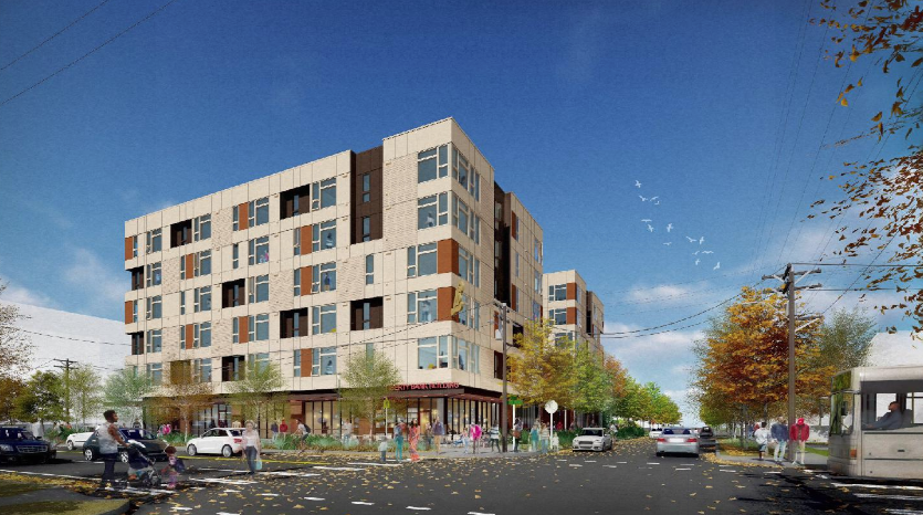
Capitol Hill Housing (CHH) is sponsoring a six-story mixed-use development that will provide new affordable housing units to the Central Area. Located on the corner of E Union St and 24th Ave, approximately 114 apartments and 3,264 square feet of ground floor retail space will be constructed as part of the development. A rezone of the site was necessary to facilitate the proposal since existing zoning would only allows 69 dwelling units similar in design to those proposed by CHH. The development is proposed on the site of the former Liberty Bank Building, which was the first African-American owned bank west of the Mississippi.
The rezone increases overall maximum building heights and floor area by going from NC2P-40 and NC2-40 to NC2P-65. The mixed-use zoning allows a 65-foot tall building and applies special Pedestrian-designation requirements to the property. Since the development is targeted at delivering affordable housing, the residential components of the project are exempt from the mandatory housing affordable requirements for residential uses since it would easily exceed them. The small amount of commercial uses are also exempt.
Technical Rezone Corrections in Belltown
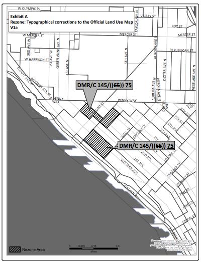
When the Downtown and South Lake Union rezones were adopted in March, there were typographical errors in them for two areas of Belltown. The rezones changed the blocks from DMR/C 125/65 to DMR/C 145/65, which increased the maximum residential height limit but not the base maximum height limit. The City Council adjusted the zoning yesterday by increasing base maximum height limit by 10 feet to DMR/C 145/75, which has a base maximum height limit of 75 feet. This makes the zone consistent with the floor area ratio provision in SMC 23.49.011.A.1. The rezone correction also makes a minor adjustment to the applicability of the high, medium, and low mandatory housing affordability performance and payment map.
Revised Urban Design Guidelines
Two sets of new neighborhood design guidelines were adopted for Mount Baker Town Center and Pike/Pine. In the case of Mount Baker Town Center, the adopted design guidelines are entirely new. The guidelines apply to the growing station area town center, which follows the spine of Rainier Avenue from S Bayview St to S Walden St. The Mount Baker design guidelines identify how new development should respond to local urban form and architectural context. Typical with design guidelines, direction is also provided on a host of other design issues, such as public space, street-level interaction, and architectural approaches to construction.
First adopted in 2010, the Pike/Pine design guidelines were created to reflect priorities of the Pike/Pine Conservation Overlay District, which was established a year earlier in 2009. Prior to that, the general Capitol Hill neighborhood design guidelines had covered the Pike/Pine area. The conservation district overlay seeks to promote preservation of the local character through sensitive designs in new development. The conservation district’s design guidelines are now in their third iteration.
The impetus for revised design guidance came from changes to the Land Use Code in 2014. These changes centered on language for departures from development standards within the conservation district. The goal of the changes was to allow more flexibility in developing design solutions that compliment and retain the architectural character of the conservation district. Thus, updated design guidelines were necessary to help implement those code changes.
Specific changes to the design guidelines include the addition of conservation district objectives, new design priorities in the neighborhood, and new graphical examples of character-responsive development.