Tacoma is in the process of developing a subarea plan for Tacoma Mall and its environs. The plan will guide growth and redevelopment of the district over the next 20 years. The effort builds upon past planning efforts for area. As part of the subarea plan, Tacoma is also conducting environmental review and intends to publish an Environmental Impact Statement at the conclusion of the planning process. Two primary alternatives are being evaluated as part of the planning process:
- No action. One alternative would largely the status quo with no regulatory changes and only implementing a few projects under the city’s control.
- Action. Another alternative would create a new vision for the subarea, establish new regulatory requirements for development, and plan for new transportation, recreation, stormwater, and other public investments. This alternative would also expand the boundaries of the Tacoma Mall Regional Growth Center.
General Context for Subarea Plan
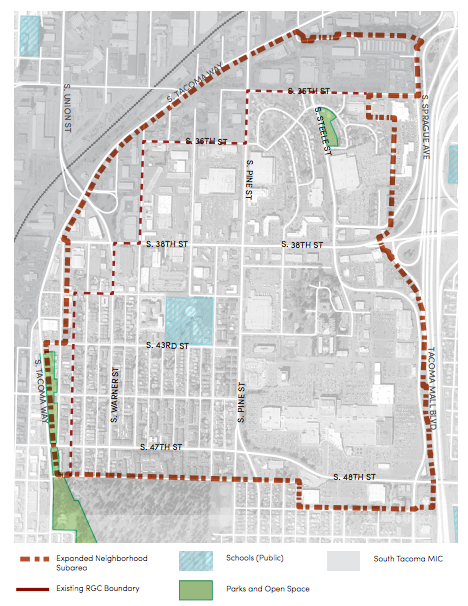
The Tacoma Mall is designated as a Regional Growth Center (RGC) by Puget Sound Regional Council (PSRC), which is just one of 24 in the four county region. The designation typically is associated with districts where large shares of jobs and housing are to be accommodated. Areas with an RGC designation also get a priority for federal transportation dollars that are administered by the PSRC. The RCG boundaries are proposed to be expanded by more than 116 acres.
Though the planning effort is intended to in part increase development capacity, the corresponding land use changes do not necessarily equate to significant increases in additional population, housing, and jobs through 2040. In most cases, the increased growth from added development capacity is anticipated to be about 10%:
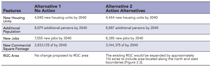
Still, the changes would almost certainly reserve future development capacity for years beyond the 2040 planning time horizon.
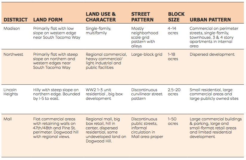
The subarea plan breaks the Tacoma Mall Regional Growth Center into four distinct districts:
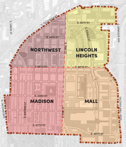
Separating the subarea into smaller districts allows for a higher degree of differentiation in overall character, design, and pattern. The following table highlights some of these key features currently present in the districts:
Proposed Land Use Changes
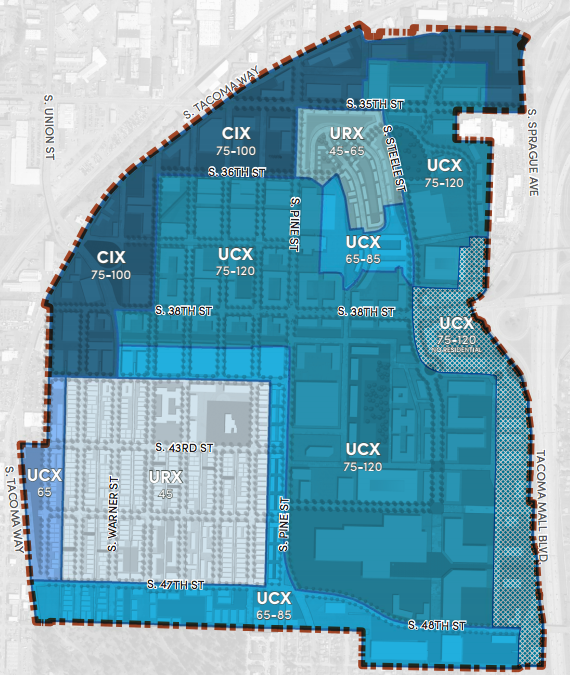
Proposed zoning changes would remake much of the Tacoma Mall Regional Growth Center and could end up looking very close to the zoning proposal above. The following table gives a sense of how the different zoning districts are intended to work and the general types of rezones that are proposed to occur:
| Existing Zoning Districts | Proposed Zoning Districts | Purpose of Zoning Districts |
|---|---|---|
| Urban Center Mixed-Use District (UCX) | UCX Core – 75/120 feet height UCX Transition – 65/85 feet height UCX Commercial (no residential uses) | Provides for dense residential, commercial and institutional development including regional destinations that supports walking and transit-usage. |
| Neighborhood Commercial Mixed-Use District (NCX) | Urban Residential Mixed-Use (URX) | Provides for dense housing development in walkable proximity to commercial mixed-use zones. |
| Neighborhood Commercial Mixed-Use District (NCX) | UCX Transition – 65/85 feet height | Provides for dense mixed-use development at a mid-rise height, serves as a transition between higher and lower height areas. |
| Light Industrial District (M-1) | Commercial Industrial Mixed-Use (CIX) | Provides for a mix of commercial, residential and light manufacturing, assembly, distribution and goods storage. |
All of the zoning types would allow residential development, but URX zone would be the most restrictive to non-residential uses. The other zones generally would allow a spectrum of commercial uses, including mixing residential and commercial. Light industrial uses would be more widely allowed in CIX zones than UCX zones.
Nearly a dozen different topic areas for land use regulations could see companion changes as part of zoning changes. Many of them directly relate to the Tacoma Mall subarea, but could have wider implications, too.
Pedestrian Connectivity
A new set of requirements would be added to ensure that larger development sites provide better pedestrian connectivity. The existing regulations require that development sites with 450 feet or more of frontage provide a walkway every 150 feet. At minimum, three such walkways are required for a site with 450 feet of frontage.
The proposal would require that walkways achieve higher standards than they typically do, particularly for the middle walkway in the three-walkway scenario. A developer would need to build the connection either as a full street with sidewalks on both sides or create a pathway wide enough to comfortably provide space people walking and biking. The walkways would also need to offer a direct connection to another public right-of-way.
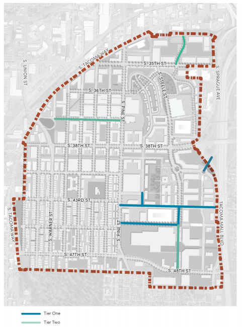
Priority Tier Connections
A tiered system for new connectivity and circulation would be established at three different levels. Tier One connections would be important to neighborhood-wide transportation objectives and be paid for by the city. Tier Two connections would largely be focused on building out district-level transportation networks and costs would be shared by both developers and city. Tacoma would require both of these tiers to be mapped and fully public. A third tier of connections are focused on providing internal pedestrian connectivity at the project (describe above); these connections would neither be mapped nor funded by the city.
Specific criteria would be established requiring development of the tiered connections based upon the size of a site and lack of a sufficient transportation network. Restrictions would be further imposed on how much development could occur within the mapped Tier One and Tier Two connections. Much of the desired transportation network is already in place, but the proposed requirements would make the system much more complete and functional as a connected grid.
Bonus Height
With the proposed zoning changes, some properties in the Tacoma Mall subarea would be rezoned to have a by-right building height limit and a higher height limit if bonuses are used. Existing UCX 75-120 is an example of how this works. 75 feet is the standard height limit by right. To achieve heights above that and up to 120 feet, a developer would need to use make 25% of the square footage residential or use Transfer of Development Rights to construct the additional square footage.
Other zoning types like NCX allow the use of bonus height such as providing public art equal to 1% of the project valuation, transit stop improvements, creating a substantial amount of ground floor retail and restaurant spaces, achieving high energy efficiency, and vegetating rooftops. A variety of technical changes are proposed in relationship to bonus options and requirements, including expanding the general bonus options more widely to zones like UCX.
Pedestrian-Oriented Streets
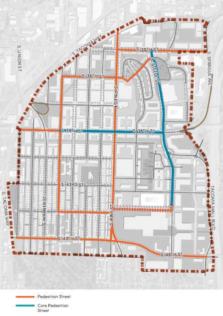
The proposal would expanded the number of streets designated as a Pedestrian Street. Only two streets are identified as Primary Pedestrian Streets, but the proposal would another five as such and introduce two Core Pedestrian Streets to the subarea. Both types of street designations establish higher level regulatory requirements to promote pedestrian-oriented development. Certain uses are prohibited at street level and additional design requirements may apply.
Drive-Through Design Standards
Drive-through facilities are specially regulated on Pedestrian Streets. These uses are prohibited from making through connections to Pedestrian Streets, must locate driveways at least 150 away from a transit stop, and locate the drive-through windows away from a designated Pedestrian Street. New requirements would be added to require screening of drive-through stacking lanes and reduce auto-orientated design. Stacking lanes would be required to either be partially enclosed in a decorative or leafy building or use a trellis type structure to reduce the appearance of the lanes. General site design requirements would also be enhanced requiring safer designs for pedestrians.
Townhouse and Multifamily Design Standards
Most of the proposed design standards for residential development are focused on townhouses. One change envisioned would prohibit locating front doors on alleys unless they are will have pedestrian access and high quality environment, such as landscaping and pedestrian-oriented amenities. Another set of changes would require townhouse orientation toward streets, additional architectural details on facades oriented toward the public realm, and other elements that improve the transition from street to units. Areas that are intended to be shared between pedestrians and vehicles would require special materials that clearly indicate either separation of modes or the shared nature of an accessway.
Additionally, all multifamily development with space between the building and sidewalk would need to make the area in between visually pleasing; parking would be entirely prohibited in such areas.
Minor Expansions and Conversions
The zoning code requires a minimum density of 30 dwelling units per acre in the RCX zone, but in the Madison District zoning is proposed to go to URX which would have a minimum density of 25 dwelling units per acre. Some property owners have expressed an interest in allowing conversion and small expansion on single-family properties without fully redeveloping. An exemption from the minimum density requirements would be allowed for conversion of single-family units to multiple units or the construction of an accessory dwelling unit or second house without needing to achieve the standard minimum density requirements. The change could be applied to all mixed use zones.
Landscaping
Landscaping standards would be expanded to require all development in the URX zone to achieve a 15% minimum tree canopy coverage per site. Small scale residential development in mixed use zones would to provide street trees where required.
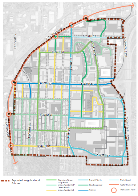
Proposed Transportation Network
To support the growth of the Tacoma Mall subarea, the planning work has identified what a complete transportation network could look like and the types of investments required. As noted before, connectivity is a key theme and reflected in both proposed regulatory requirements and public commitment to delivering. The following map shows how the full street and trail network could be built out:
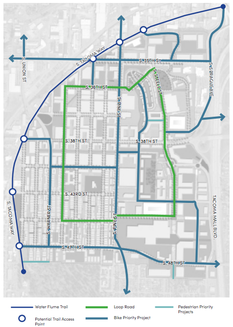
Bike and pedestrian projects would get serious attention with a slate of projects. For instance, Water Flume Trail would be extended northeast of S Pine St toward Downtown Tacoma making the non-motorized trail complete so as to offer better mobility and recreation opportunities. Arterials like S Pine St and S 47th St would get dedicated bike infrastructure. And a few small segments in the Tacoma Mall subarea would see new pedestrian-oriented projects implemented.
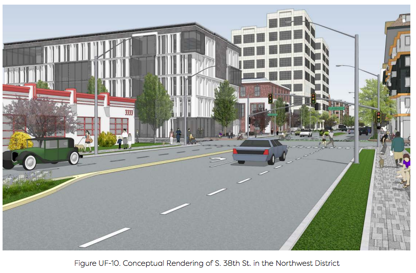
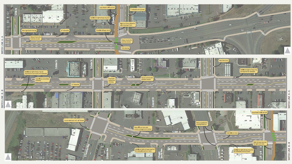
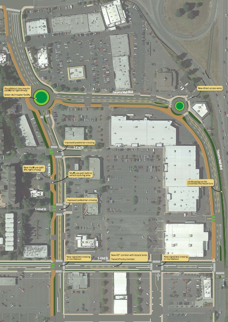
In two cases, the planning work provides a higher degree of specificity for street design. While only concepts, the designs provide a sense of how the street network at the north end of the Tacoma Mall and on S 38th St could function:
Other Planning Strategies and Next Steps
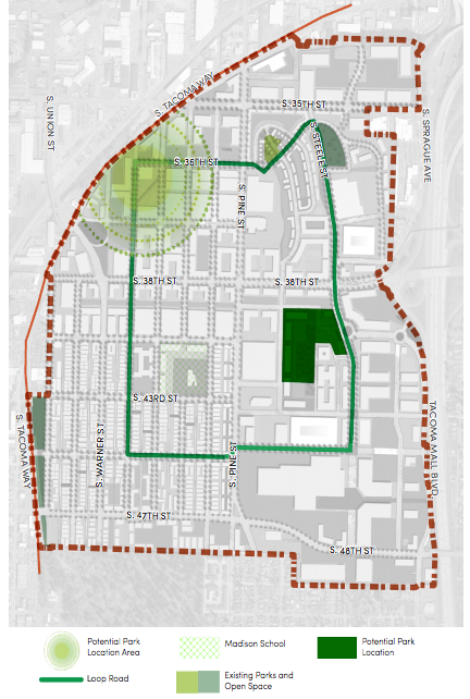
The draft subarea plan is packaged with a lot of other topics like parks and open space, infill strategies, growing jobs and businesses, utilities and public services, and funding mechanisms to realize plan elements. Tacoma is looking toward adopting a planned action ordinance with land use and zoning changes, too. This is similar to what Edmonds and Shoreline have done with similar subarea planning efforts. A planned action ordinance can allow project-level land use review to be exempt from concurrent environmental review under SEPA (State Environmental Policy Act), which can sometimes extend project review periods and pose additional legal challenges. The subarea plan will be refined throughout the fall and could be adopted in some form by early next year.
Edmonds Adopts New Urban District, Expands MFTE Program