The Seattle Department of Transportation (SDOT) is hitting its stride lately on making progress toward its goal of constructing a full bike network composed of 608 miles of bike lanes, off-street trails, and neighborhood greenways. In the past two years or so a number of major bike projects have been completed, including the Westlake cycletrack, the Roosevelt Way protected bike lanes, and big components of the bike network downtown have recently come into place.
Looking at the geographic distribution of these projects though, a trend becomes clear: most of these projects are north of I-90. South Seattle, in particular, has been largely left out of the immediate plans for safe bicycle infrastructure. The five-year implementation plan for Bike Master Plan projects includes almost 81 miles of bike facilities, including greenways and paint-only bike lanes. Of this amount, 14.5 miles are south of I-90 and east of I-5. That’s 18% compared to 42% north of the Ship Canal.
It’s also important to note that of the 14.5 miles planned in South Seattle, 5.6 of those miles are coming from the Rainier Valley Greenway, a neighborhood connector that winds through the Rainier Valley and does not provide a direct connection to and from South Seattle. Some segments of the greenway have grades upward of 10%. Without the Rainier Valley Greenway, only 8.9 miles of bike facilities are planned in South Seattle, or 12% of the total for the city.
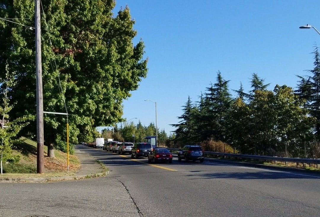
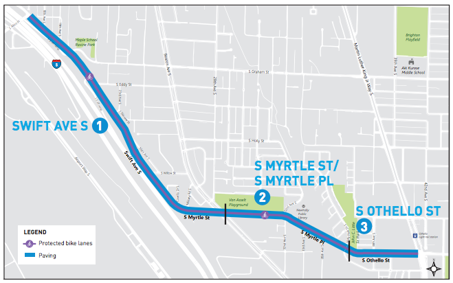
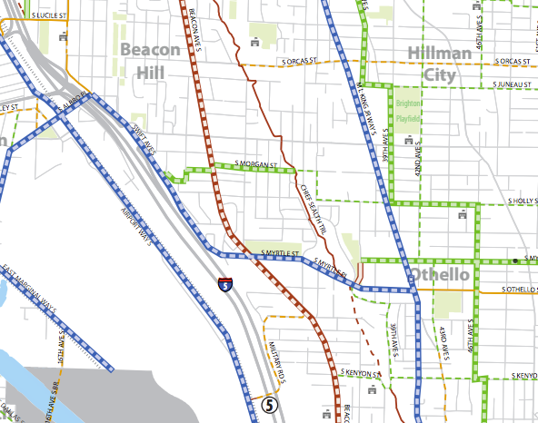
One of the planned bike facilities, and indeed one of the first protected bike lane projects in South Seattle ever, was set to get installed next year as SDOT repaves a large stretch of road next to I-5 on Beacon Hill’s west slope. Swift Ave S follows I-5 and turns into S Myrtle St and S Othello St at the light rail station on MLK Way S. This connection would allow people on bikes to get from the light rail station to the bridge across I-5 at S Albro St and into Georgetown and beyond.
Again, this is planned as part of the repaving project already happening on these streets next year: installing bike facilities on a street that calls for them in the Bike Master Plan saves money and make sense. The project has been undergoing outreach for several months now; we first covered the project over a year ago.
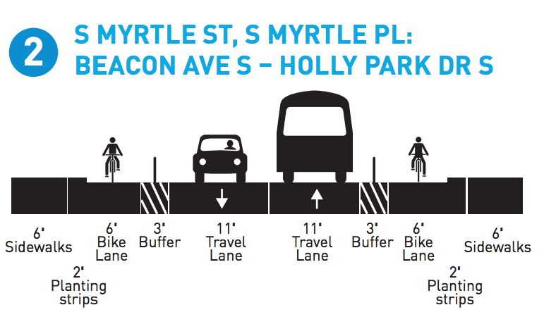
The project design is now at 90% and the project is getting ready to go out for bid for construction next year. But it appears that the protected bike lane will not be part of the project. According to a release from SDOT that The Urbanist received last week:
The Bike Master Plan recommends a protected bike lane for the Swift, Myrtle, Othello corridor. While we knew that getting bikes through key intersections would be a challenge, as design progressed for the paving project, it became clear that we would not be able to extend the protected bike lanes through the Swift/Graham and Beacon/Myrtle intersections. There is not enough room to accommodate a left turn lane and protected bike lane.
If we were to remove the left turn phase in the intersections, we would be creating a safety issue with left turning vehicles against the protected bike lane. The increased exposure of cyclists to the left hook is not an acceptable interaction at the intersections. In addition, removing the left turn lane at these intersections would significantly reduce the level of service and increase delays.
Rather than install an incomplete bike facility in this corridor, we decided to widen the existing bike lanes throughout this corridor. Widening the bike lane and painting in the striped buffer is more likely to increase driver awareness and comfort for people riding bikes.
The Seattle Bicycle Advisory Board is not pleased with this eleventh hour reversal in course for this all-ages and abilities route in a neighborhood that is lacking safe bike infrastructure. Former co-chair Adam Bartz, a Beacon Hill resident, suggested that the reason that SDOT was not able to make the design work is because the project area lies south of I-90.
Neighborhood safe streets groups are also not happy with the change, and several groups have already sent letters to the department hoping for a last minute reversal. Duwamish Valley Safe Streets, which advocates for Georgetown and South Park, contended that removal of the bike lanes is a shirking of Seattle’s Complete Street ordinance:
Current facilities on these streets do not safely accommodate all modes. The Complete Streets ordinance (Ordinance 122386) directs Seattle Department of Transportation to design streets for pedestrians, bicyclists, transit riders, and persons of all abilities, while promoting safe operation for all users, including freight. The Swift/Othello/Myrtle planned improvements include improvements consistent with recommended facilities in the 2007 Bicycle Master Plan and including them in the project design is in accordance with the Complete Streets ordinance, SDOT’s mission, and public design input.
West Seattle Bike Connections and Beacon Hill Safe Streets have also either submitted letters in support of the project or are on the verge of drafting them. These groups seem adamant that the engineering constraints SDOT doesn’t feel they can overcome can be designed around. If you want to add your voice and encourage SDOT to not downgrade this facility, email pavingoutreach@seattle.gov.
Seattle’s District 2, which is home to roughly 15% of the city’s population, saw a widely disproportionate number of the city’s traffic fatalities over the past 10 years: close to 30% of the fatal traffic collisions on our streets between 2006 and 2016 happened there. Bike projects, which of course improve mobility for people on bikes, also frequently create safer streets for all users by reducing speeds.
SDOT is about to begin the process of revising the five-year work plan for Bike Master Plan projects. One thing is clear: this segment of the city needs a lot more attention in the next plan than it got in the previous one. If the Swift Ave S corridor is taken off the table, the City better be prepared to make up for it elsewhere.
Featured image: Robert Getch
SDOT Reveals New Southeast Seattle Repaving Project Concepts