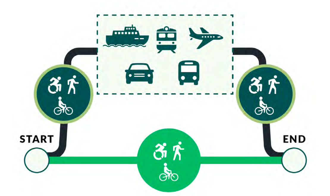
Intended to serve as a compass for the future of walking, biking, and rolling on or across state roadways, Active Transportation Plan 2020 and Beyond – Part 1 takes an in-depth look at the present state of active transportation and sets the groundwork for the future. Mandated as a comprehensive update to the 2008 Bicycle Transportation and Pedestrian Walkways Plan, this new plan will be used to inform the Washington State Department of Transportation’s (WSDOT’s) future policy decisions, investments, and improvements. Overall, WSDOT defines the plan’s vision as the eventual creation of a statewide active transportation “network that works as well for people walking or rolling as it does for people using motor vehicles.“
That’s a bold goal to set forth, achieving it won’t be easy. To this end, Part 1’s 300 pages doesn’t exactly make for light reading. Part 2, which will be published later on this year, will dive deeper into analysis and implementation policies and identify markers to measure the plan’s effectiveness.
Here are some highlights from Part 1.
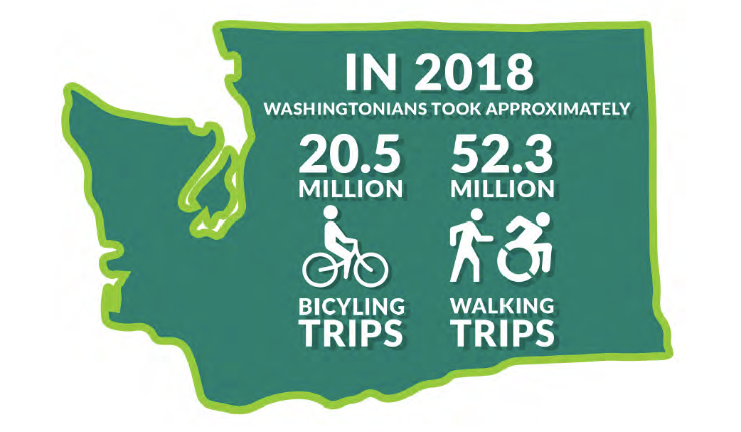
1. Walking, biking, and rolling are already essential forms of transportation across Washington
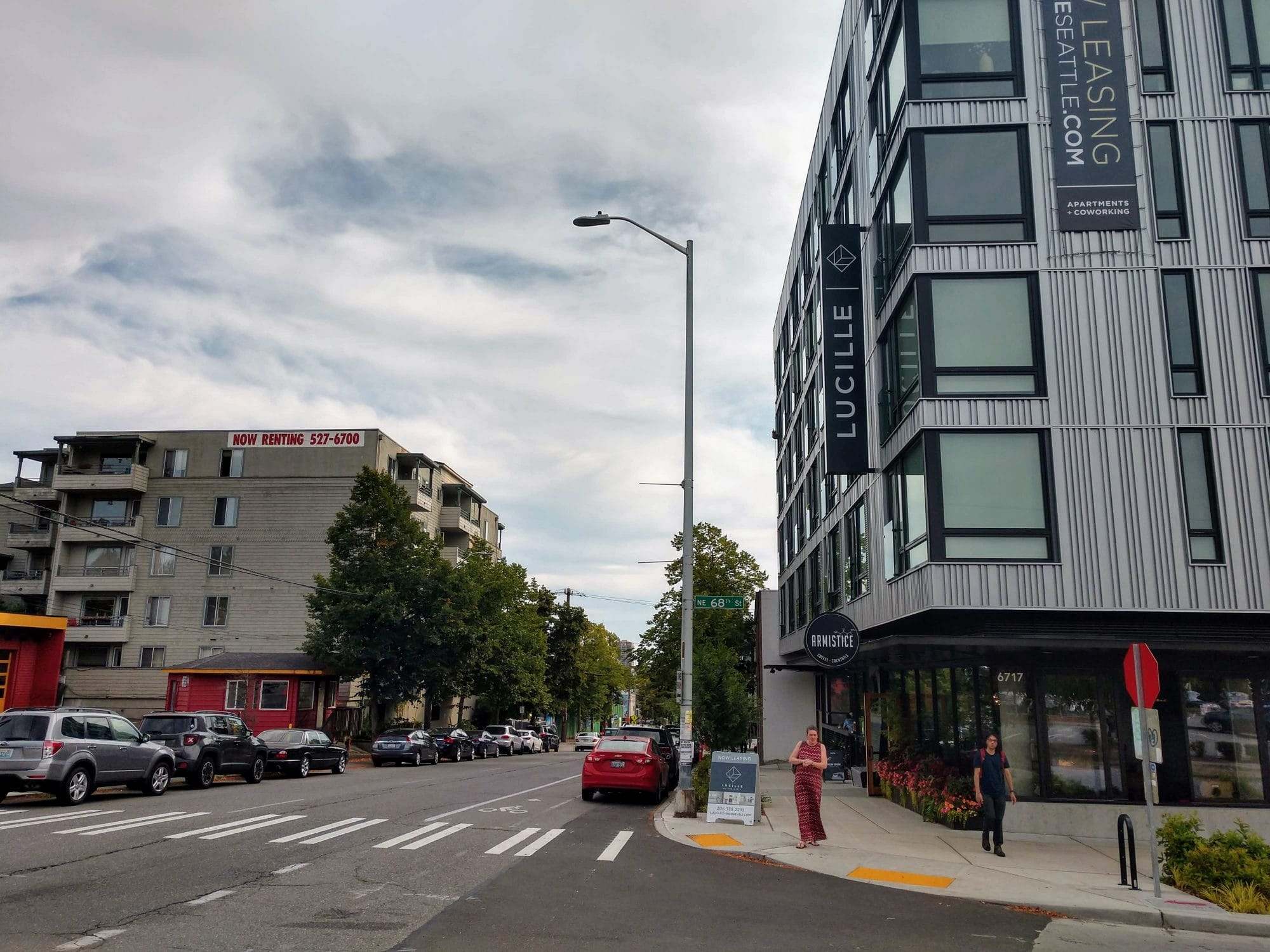
It can be easy to overlook the fact that all trips start and end with active transportation, even if it only means strolling out the front door of your home to a parked vehicle. However, for 21.4% of Washingtonians, who do not have drivers’ licenses, active transportation, transit, and ride sharing are primary means of travel. Across the state, nearly 191,000 households do not own a vehicle. Car-free households are found in every county in the state, underscoring the need for access to safe active transportation choices in all communities, and not only in more urbanized areas.
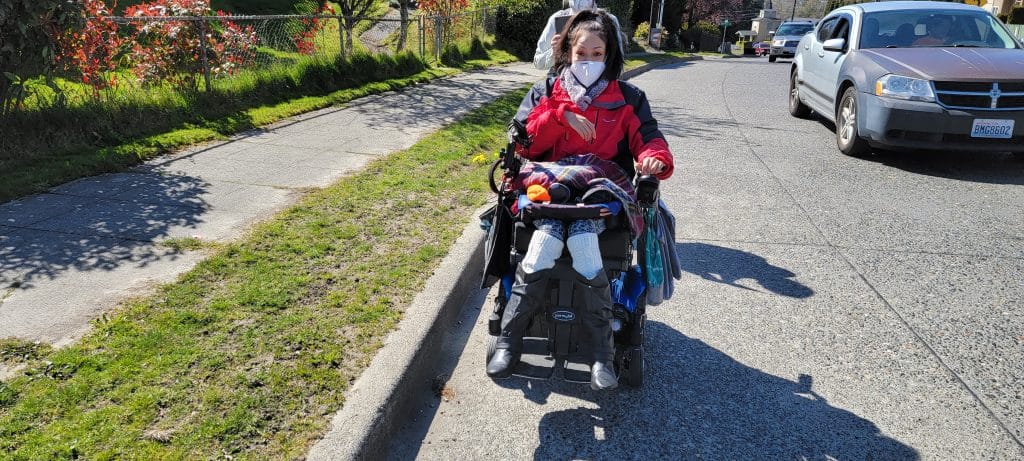
The percentage of Washingtonians who do not drive is widely expected to increase as the proportion of elderly people rises in the population, underscoring the need to make improvements now. Additionally, Washingtonians with disabilities are less likely to own a vehicle or use a vehicle if they happen to own one. Disability Rights Washington is currently engaged in a #MobilizeWA Planning survey aimed at collecting data on how people with disabilities travel across the state.
2. Understanding unmet demand for active transportation infrastructure is a challenge
Despite the important role active transportation plays in moving people across Washington, it can be hard to make the case for investments in new infrastructure. That’s because current levels of use are difficult to track and unmet demand is difficult to measure.
According to WSDOT, counting vehicles (i.e., users), which is widely used to assess the needs of motorists, does not translate well as a data collection tool for active transportation. Even so, WSDOT continues to use user counts, which are taken both by its 80 permanent pedestrian and bicyclist counters located on trails, city streets, and state routes around the state, as well as by manual short duration counts conducted by volunteers, usually during peak commute hours.
While the data taken from these user counts is helpful, it is woefully incomplete. Incomplete connections may result in active travelers not reaching their final destinations, so use can appear low, even when need is high. Additionally, user counts, which tend to focus on travel by commuters, may not accurately reflect travel patterns of women and low-income populations nor Black, Indigenous, and people of color (BIPOC) folks. These counts are also especially inadequate at logging multi-purpose trips.
However, unmet demand remains even more difficult to measure than current trends. To illustrate the difficulty, WSDOT presents in the report the example of roads in the United States in 1910 before motor vehicles became the dominant mode of transportation. At that time, it would have been impossible to understand how people driving motor vehicles would have chosen to use roads because the infrastructure intended for their use simply did not yet exist.
WSDOT makes the argument that the same can be said about people traveling by active transportation today. Since the vast majority of infrastructure is designed for cars, it is impossible to understand how people would choose to travel differently if the transportation network were designed to serve walking, biking, and rolling equally as well.
Solving this issue will not be easy. It will require holistic understanding of people’s travel needs, as well as imagination, a willingness to adapt to new situations, and the financial investment to make sweeping changes possible.
3. Investing in active transportation infrastructure would save lives, especially in low-income communities and communities of color
But for all its challenges, creating a network that truly serves people walking, biking, and rolling for transportation remains crucial, with equity rising to the top of the list. By all measures, the current state of active transportation in Washington is inequitable — and the consequences can be disastrous.
People who walk, bike, or roll in BIPOC and/or low-income communities are disproportionately likely to suffer severe injuries or death from traffic collisions. Data from the report shows that about 51% of fatal and serious injury crashes occur in census blocks identified with higher poverty levels than the state average, a designation that only applies to about 44% of the state’s census blocks. Additionally, while only 24% of census blocks are identified as being home to a higher number of people of color than the state average, these census blocks represent 33% of fatal and serious injuries for pedestrians and cyclists.
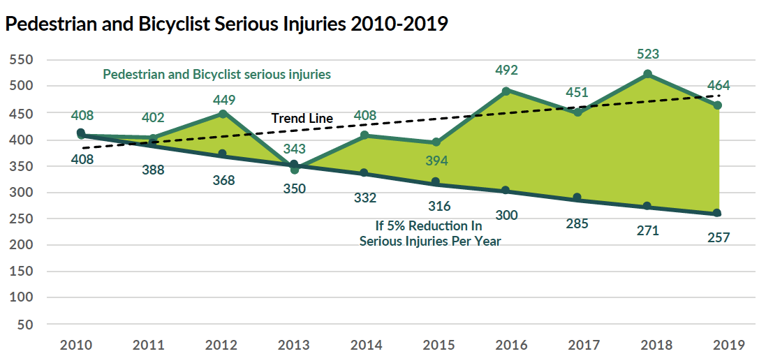
When viewed as a whole, statistics show that the number of serious injuries and deaths among pedestrians and cyclists across Washington State has generally outpaced population growth over the last 10 years. While Washington’s population increased by 11.86% during this period, fatalities for pedestrians, which includes people using wheelchairs and other small rideable devices, rose by a whopping 62.5%, while the overall trend in cyclist fatalities increased by 61.4%.
4. Speed reduction can be a powerful tool for increasing safety
The serious safety issues that confront pedestrians and cyclists can be depressing to read about, especially since good news typically seems to be in short supply. However, the report presents data demonstrating that reducing speed limits on roadways can improve safety conditions not only for pedestrians and cyclists, but also for drivers. In fact, in some instances, reducing speed limits could be preferable to investing in infrastructure changes. As a whole, WSDOT takes the position that both speed limit reductions and infrastructure changes should be considered when revamping roadways to make them safer.
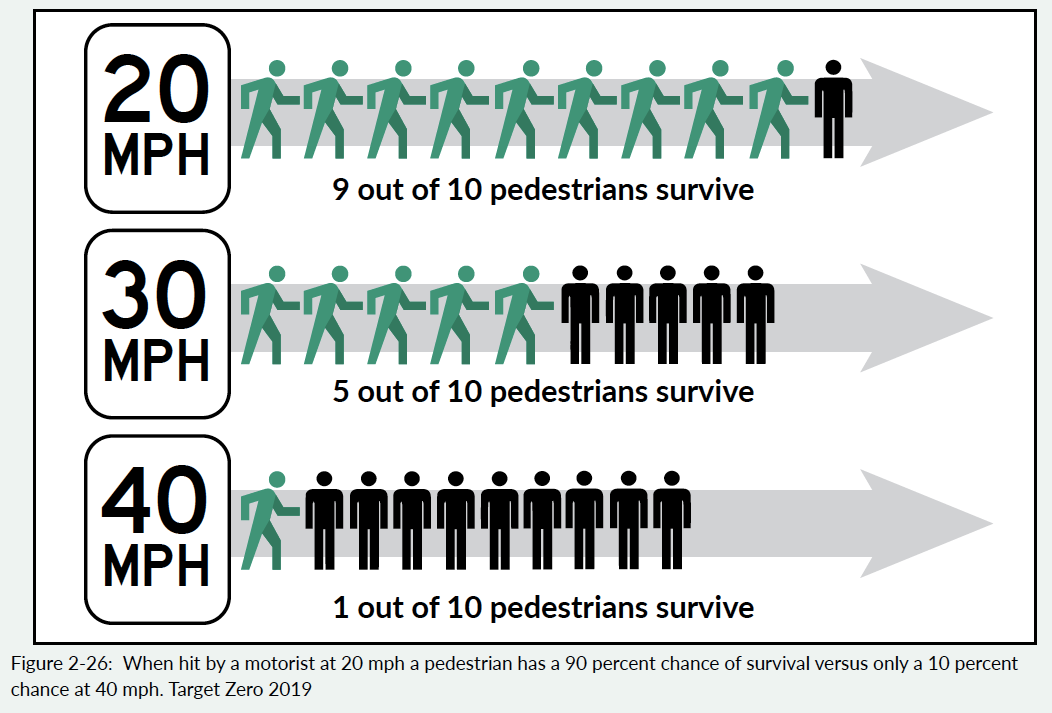
In 2020, the Seattle Department of Transportation (SDOT) reduced the speed limit to 25 mph on many arterial streets, including several WSDOT owned roadways. The fact that WSDOT is recognizing speed reduction as a safety tool could mean that more Washington cities could see similar changes in the future.
5. Investing in active transportation would be good for WA state’s economy
Data suggests that improving connections for walking, biking, and rolling across the state would also create much needed jobs. Even better, according to a study completed as part of the American Recovery and Reinvestment Act (2009), active transportation projects created 17 jobs per $1 million investment — more than any other type of transportation project. Additionally, since these projects are smaller in scope than major infrastructure projects, smaller firms, including disadvantaged businesses, have a higher likelihood of winning project bids.
But the financial benefits for Washingtonians, especially BIPOC and other historically disadvantaged communities, do not stop there. Making active transportation safer and more accessible would create positive ripple effects across the state economy, especially among lower-income residents. According to a 2019 study by the American Automobile Association (AAA), the average American household spends about $9,561 annually to operate a vehicle. Thus, allowing households to forgo ownership of just one car could equate to nearly a $10,000 raise, a substantial income bump that would allow for Washingtonians to better afford life’s necessities and save for the future.
6. Reconnecting communities across state highways is an area of untapped potential
Decades ago, when WSDOT expanded its highway system, it paid little heed to the long-term impacts these roadways would have on surrounding communities. Now the agency is trying to better understand how state highways divide communities and act as barriers for active transportation. As part of the current plan, WSDOT undertook a multimodal connectivity study using a new set of route analysis methods that should be released later in 2021. Some of the preliminary data gathered for this survey was incorporated into the current plan, including a Route Directness Index (RDI) that shows how far out of their way a person would need to travel to cross a state highway.
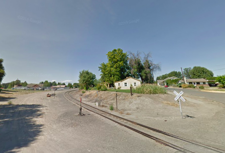
The town of Granger, population 4,000, is highlighted in the plan as an example of a community in which a state highway, in this case SR-223, acts as a barrier to active transportation. The presence of the highway forces people to use 3rd Street, a street that experiences high volumes of traffic, to travel to where most of the town’s destinations, including schools are located. However, using 3rd Street diverts children traveling to school significantly out of the way. As a result, many children opt to use a more direct route following the railroad tracks that pass under SR-223.
Connecting communities across state highways would not only address substantial safety concerns like those observed in Granger. Safe and well-connected active transportation routes could improve public health and support small business districts.
7. The time for action is now
The plan acknowledges in its introduction that the best time to build a trail, or a whole multimodal transportation network, will always be 20 years ago. (The same goes for rail transportation as well!) But rather than fret over the missed opportunities of the past, the plan makes the case for urgency today, emphasizing the many environmental and health benefits offered by active transportation. Additionally, the plan emphasizes the important role active transportation plays in decreasing carbon emissions, presenting active transportation as an essential tool in the fight for our planet’s future. The 10% dip in US carbon emissions that occurred in 2020 as a result of the Covid pandemic provides a vivid example of the environmental benefits that could be reaped from shifting toward wider use of walking, biking, and rolling for transportation.
But will WSDOT shift from car-centric planning and investments?
It’s no secret that investments in state highways have far outpaced investment in active transportation infrastructure for decades. Even so, the report presents a few statistics that while galling, emerge as reason for optimism. According to the report, for approximately the same cost as one Seattle-area freeway interchange about 300 miles of trail could be constructed. Furthermore, for the same average statewide cost of one freeway interchange each two years, Washington could build out an entire statewide trail network in a couple decades.
At face value, decreasing spending on state highways feels eminently doable. Yet the State’s track record of prioritizing highway projects over active transportation projects does not exactly instill confidence. Still this data clearly shows that with the right amount of will, a meaningful expansion of active transportation infrastructure is possible.
WSDOT Is Developing an Active Transportation Plan and Seeking Input