The Seattle Department of Transportation (SDOT) has announced that a planned north-south bike connection in Beacon Hill is not scheduled to start construction until the spring of 2024, a delay of a full year and another setback to fully connecting the southeast quadrant of Seattle to the rest of the city with separated bike infrastructure. In addition, the department has confirmed that it has conducted yet another parking study around the project’s impacts, something that could potentially put the route in jeopardy again.
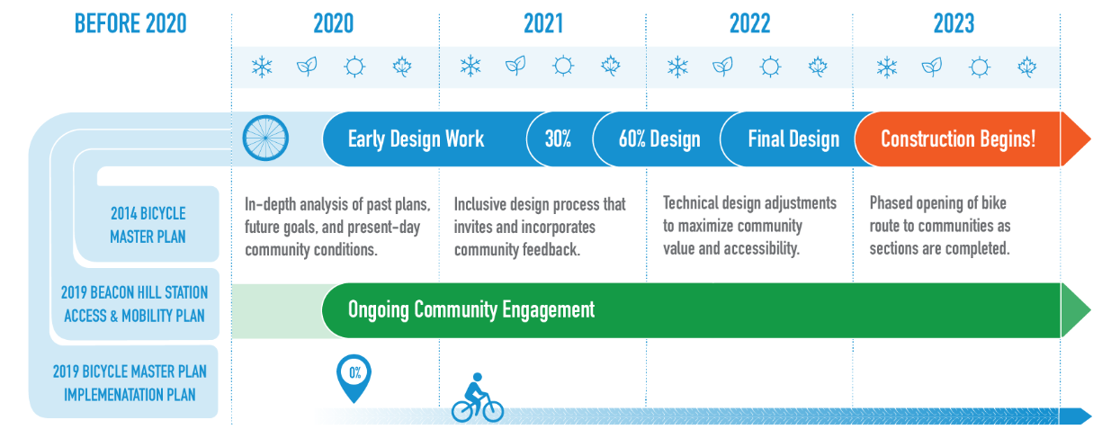
SDOT spokesperson Mariam Ali confirmed the delay and stated it had been caused by a lack of staff capacity and an “ongoing problem with survey equipment being stolen.” The project’s website has not been updated since this past March; the construction timeline still listed there is mid-2023. A 2021 version of the project website showed construction starting in early 2023.
The Beacon Hill bike route was funded in 2019 directly by the Seattle City Council with the express intention of filling in a key gap in Seattle’s bike network, along with the planned connection on MLK Jr Way S and the Georgetown to South Park trail. Planned in three segments, most of the route is set to run on Beacon Avenue, but for the segment north of Beacon Hill’s light rail station, three options were put forward: 15th Avenue, 14th Avenue, and a combination of streets including 12th, 13th, and 14th Avenues. The department spent around two years collecting feedback on those options.
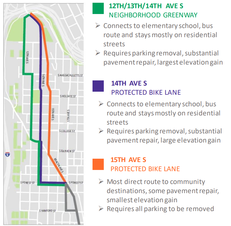
In all outreach, the 15th Avenue S route was the preferred one by a large margin. A 2020 survey combined with outreach events in 2021 showed 64% of respondents preferring 15th Avenue, with the remainder evenly split between the other two options. At the same time, SDOT conducted a parking study to determine the impacts of parking removal that would be required to create the route on 15th Avenue. It found average parking utilization was just 47% along 15th Avenue. SDOT considered converting the street to one-way operations in order to retain parking but found that would create delays for buses in the area.
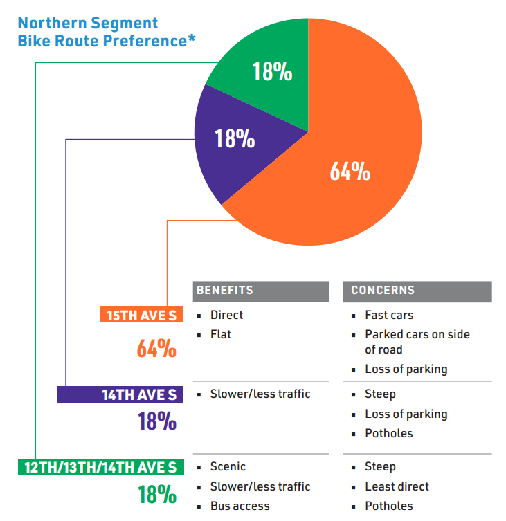
According to SDOT, the 15th Avenue option would require removal of 133 parking spaces along the street, in contrast with over 200 spaces for the 14th Avenue option. But parking removal is definitely the most contentious part of the project. This year, SDOT agreed to ask a third party to conduct a new parking study to verify the data collected during the pandemic.
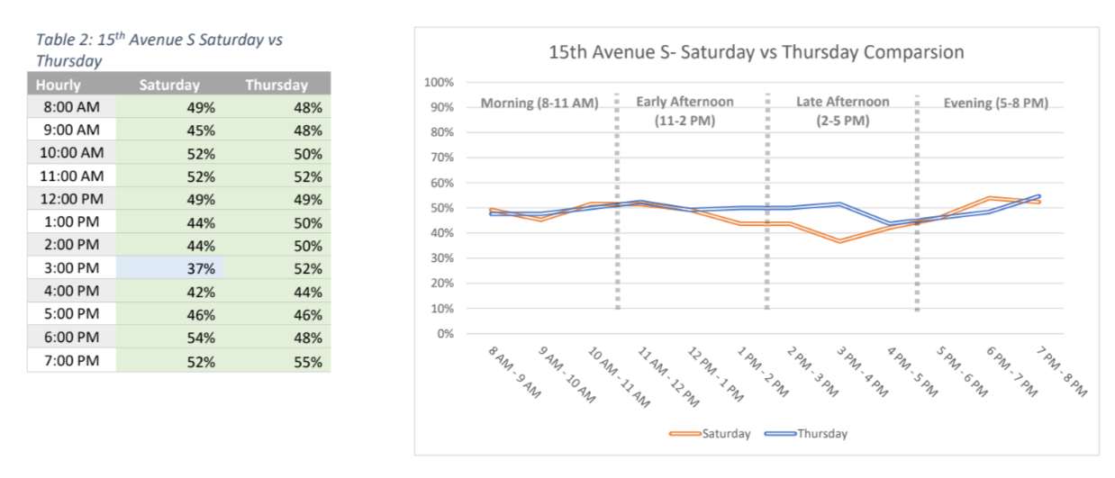
The 2022 parking study, conducted by Toole Design, confirmed the findings of the previous study, with utilization directly on 15th Ave S this past June at around 50% throughout the day on both a Saturday and a Thursday. But it’s not clear how the outcome of the study could impact the project’s design. At a meeting of the Beacon Hill Council, a neighborhood group, earlier this month, SDOT staff were asked how they were using the information from the study. “We want to make sure [with] that removal of parking, that there’s other places for people to park, that there’s alternate locations for people. So that’s how we’re using this data,” Project Manager Janet Loriz said, calling the parking study the first step, with the department potentially needing to go “property-by-property” in the coming months. “This is the time when we are planning a very robust public outreach effort,” Loriz said, after over two years of outreach around the project already. But SDOT has limited tools available to directly mitigate the loss of parking.
The long timeline for this project is a notable contrast with other projects in the city, including walking and biking projects. The Green Lake Outer Loop project, which is nearing the end of construction already, was not yet a fully conceived idea within the department when the city council allocated funding for the Beacon Hill project, and yet it was prioritized even as north Seattle already has a large share of the city’s protected bike lane network. “Each project has its own unique neighborhood context that informs our design process,” SDOT’s Mariam Ali wrote when I asked about this. “For the Green Lake Outer Loop project, the preferred design by SDOT and the community tied into the existing bike facilities in the area and didn’t have parking impacts.”
The delay in construction has a real impact on the ability for people to get around safely by bike. It also leaves more time for the project to be criticized over possible impacts that aren’t even fully known. According to SDOT staff, the project is approaching 10% design, allowing early renderings of the project to be available this month. SDOT’s internal Complete Streets Steering Committee must approve the project before the 30% design stage, with complaints over parking loss likely to be at the center of that conversation.
As planned, the Beacon Hill protected bike lane fills a huge gap in the city’s planned bike network in District 2. With construction now a minimum of 18 months away, there are a lot of decision points left that could cause this project to be weakened or unravel entirely. If that happens, it would be a massive setback toward correcting the significant imbalance between neighborhoods where the city provides safe bike infrastructure and where it does not.
SDOT Selects 15th Avenue S for North Beacon Hill Protected Bike Route