

A second Eastgate stop on the Issaquah-Kirkland line could turn a former airfield into a vibrant mixed-use area.
As Sound Transit grapples with its budget shortfall, some have suggested cutting the light rail extension from South Kirkland to Issaquah (or replacing it with buses) to prioritize funding for Seattle. But this is a lazy take – it ignores Sound Transit’s principle of sub-area equity, and more importantly, the staggering potential for transit-oriented redevelopment along the route.
Let’s look at how the Eastgate neighborhood in Bellevue could transform by the time light rail arrives in the 2040s.
Link from South Kirkland to Issaquah
Voters approved the Link extension from South Kirkland to Issaquah as part of Sound Transit 3 (ST3) back in 2016. It’s one of the last elements of the ST3 system, with planning set to start in 2027 and service commencing around 2041-2044.
For now, the only official information is the “representative project”, a napkin sketch that’s unchanged since the vote passed. It shows light rail running about 12 miles from South Kirkland park-and-ride to Issaquah Central, sharing the existing 2 Line tracks through the heart of Bellevue, and adding four new stations and about nine miles of new track. The new track lies mostly within the I-90 median and Eastrail corridor, allowing long stretches to run at-grade, minimizing construction costs and impacts.
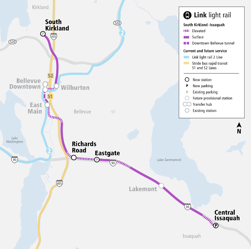
Critics of the planned extension point out that it doesn’t extend far enough into Kirkland or Issaquah to reach their respective downtowns, merely running through the lower-density areas in between. Today, that’s true: the area is dominated by sprawling office parks, industrial uses, and car-oriented shopping malls. But to see the potential, we need to look beyond the current land uses. What matters more is how the area will look in two decades, when light rail arrives.
Inspiration: transforming Bel-Red (2009-present)
Fortunately, nearby Bel-Red provides an excellent model. Once an industrial zone, it’s transforming into an urban corridor. In the earliest plans for the 2 Line, then known as East Link, light rail was expected to closely follow State Route 520 between downtown Bellevue and Redmond, skirting around the forgettable area in between. But fast-forward 15 years, and what actually happened is much more exciting: a series of transit-oriented urban villages are blossoming along the route, from Spring District, to Bel-Red, to Overlake Village.
In hindsight, three essential ingredients enabled this transformation: (1) Sound Transit picked an alignment through the area, rather than around it, bringing large swaths of land into the vicinity of new stations; (2) the City of Bellevue boldly laid out a new street grid to break up existing large parcels, with urban amenities like wide sidewalks; and (3) the whole area was upzoned to allow mixed use redevelopment, with the highest density closest to the light rail stations.
Together, these changes are catalyzing significant private investment. While the full build-out will take decades, many projects including thousands of housing units have already been built, with more in the pipeline. Some street corners are almost totally unrecognizable. Here’s a real before/after of the newly rebuilt 132nd Avenue NE in Bel-Red, with new sidewalks, bike lanes, and eight-story apartment buildings clustered around the light rail station.

The striking transformation in Bel-Red was achievable in part because the prior land uses were so forgettable: the City and Sound Transit could afford to acquire new right of way, and the step-change in value from upzoning spurred redevelopment. Bel-Red illustrates a sort of “best case scenario” when major regional transit investments and whole new neighborhoods are planned together.
Could we replicate this success along the light rail to Issaquah?
Link station at 156th Ave SE / Airfield Park
The first step would be a well-situated station.
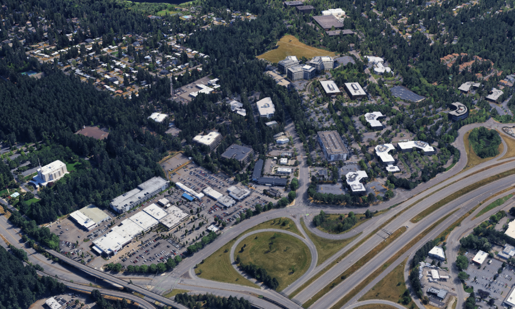
Sound Transit’s representative project calls for two stations in Bellevue, at Richards Road near Factoria and Eastgate park-and-ride, before light rail transitions into the I-90 median for the five miles to Issaquah. This misses what might be the most promising opportunity for redevelopment: the area around 156th Avenue SE. Previously an airport, it’s over 100 acres of underutilized offices and parking, on the same side of the highway as the train. For perspective, that’s three times larger than Spring District! It’s also near Airfield Park, where the City of Bellevue plans to locate its new Aquatic Center.
A better alignment would see light rail pass under 148th Avenue SE and its access ramps in a retained cut trench, to enable a convenient station on the near side of SE Eastgate Way at 156th Avenue SE, before transitioning to the I-90 median. This alignment is only about 0.1 miles longer and could be accommodated without any property impacts or reconfiguration of the I-90 ramps just by tightening the cloverleaf to a radius more like the NE 8th St interchange in downtown Bellevue. (The current ramps are almost double that radius!)
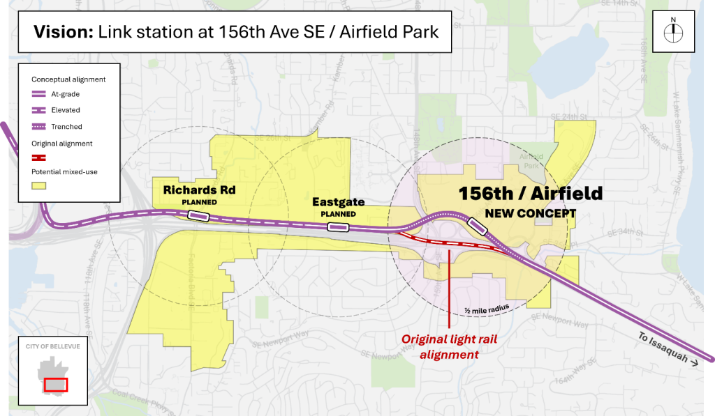
The station itself could resemble the current trenched station at Spring District. It could be an additional infill station, or a relocation of the provisional Lakemont station. Either way, failing to plan ahead for a station here would make it much harder to add later, with trains already back in the I-90 median.
New walkable local streets
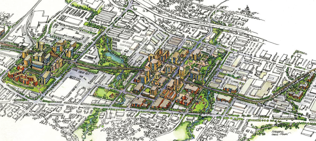
The next step would be an urban street grid. To orient the neighborhood around transit, people need to be able to comfortably walk or bike between the station and where they’re going. Fortunately, the area already has avenues at regular intervals – like 156th, 158th, and 160th – so what’s missing are the cross-streets, namely an extension of SE 33rd Street and all-new SE 34th and SE 35th Streets. Here’s one possible layout that achieves block sizes similar to Bel-Red, about 280 feet by 400 feet.
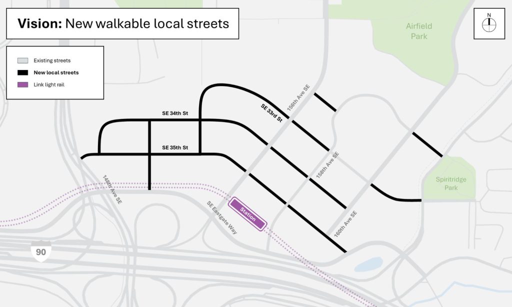
As in Bel-Red, these new local streets would prioritize walkability, and with minimal through traffic, they could be much narrower than arterials, perhaps just one lane in each direction plus planting and sidewalks. They could either be built by the City’s capital improvement program, extracted from private developers, or more likely a strategic combination of both, with the City and Sound Transit prioritizing the immediate station area and redevelopment filling in the rest over time. As in Bel-Red, the key is to enshrine the required new streets in code early.
Increased density and mixed-use
The final step would be to amend the Land Use Code to allow mixed-use redevelopment around the light rail station. Concentrating growth near transit not only maximizes how many people can live/work car-free, it actually helps preserve the surrounding single-family neighborhoods, too. With mixed-use zoning, active uses like restaurants, storefronts, and daycares add vibrancy at ground level, while housing and offices are stacked efficiently above.
For a conservative baseline, we could apply the exact same zones and dimensional requirements that Bellevue approved last year for Bel-Red. This would limit building heights to 150 feet (squat high rises) in the blocks nearest to the station, then 70 feet (five-over-ones) in the blocks beyond that, and finally 45 feet (townhomes). Here’s how that might look fully built-out, using actual building designs from the area:
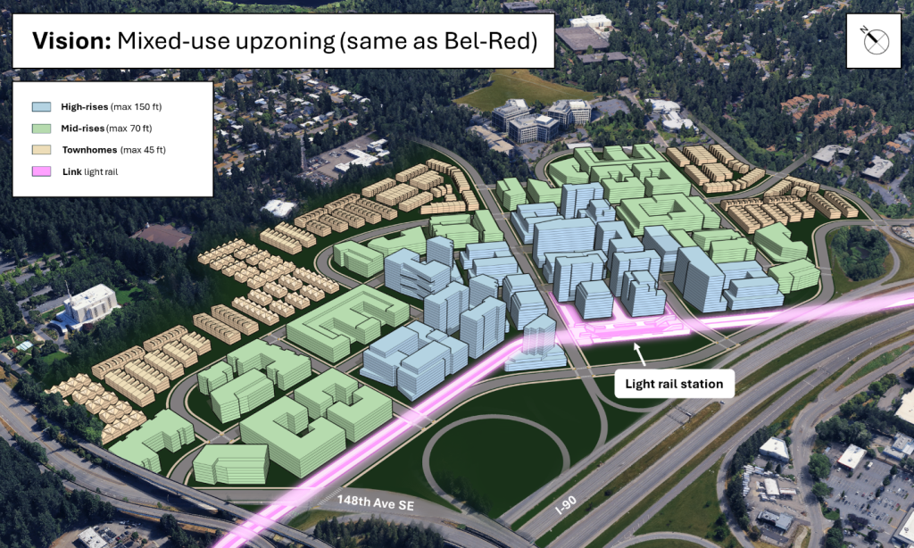
This example delivers about 9.5 million habitable square feet on the 3.5 million developable square feet of land (after accounting for streets), for an aggregate floor area ratio (FAR) of about 2.7 – nothing crazy. If this were 100% housing, it would be over 9,000 units within a half-mile walk of transit.
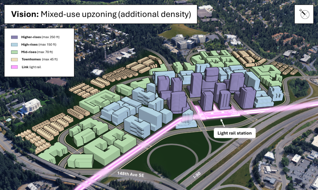
For a more ambitious example, we could incorporate a few blocks of the Mixed-Use Highrise (MU-H) district approved last year for Wilburton, which allows apartments and condo buildings up to 250 feet. This pushes habitable square feet over 11 million, or about 11,000 housing units, with an aggregate FAR of just over 3.0.
We may not think of Eastgate as particularly desirable today, but its prime location is hard to argue. Once light rail arrives, it’ll be just a few stops from downtown Bellevue and downtown Seattle, miles closer than many other growth centers. It’s surrounded by parks, including the soon-to-be-developed Airfield Park and Bellevue Aquatic Center. It’s a short drive to the mountains. A radical transformation isn’t far-fetched – Bel-Red’s history shows that it’s more likely than no change at all.
What happens next
Now is the time to start laying the groundwork. In 2026, the City of Bellevue is set to update its subarea plan for Eastgate, and in 2027, Sound Transit will kick off planning the light rail extension between South Kirkland and Issaquah. The potential for urbanization along the corridor is staggering, and Eastsiders should urge both their elected officials and Sound Transit to pursue a truly ambitious vision. Let’s swing for the fences and create the next Bel-Red!

Cosmos Darwin (Guest Contributor)
Cosmos Darwin lives car-free on the Eastside. He’s passionate about walkable streets and good public infrastructure, and he delights in riding the 2 Line every day for his commute. He is a 2025 graduate from the Bellevue Essentials civic leadership program, where he was voted class graduation speaker.