Among all the Link light rail extensions unleashed by Sound Transit 3 (ST3) lurks a weakest link: the Purple Line to Issaquah. But we can fix that.
It starts and ends at a parking lot.
If it were built as currently planned, its Issaquah terminus would be one mile away from its city center and almost 4.5 miles away from the Issaquah Highlands. With its current routing, the Purple Line is set to become yet another compromise in favor of the Eastside’s currently car-oriented landscape. That’s arguably because the Purple Line is public transport designed for now. Sound Transit spending a few billion dollars building a light rail to the low-rise “downtown” of Issaquah is simply not feasible at the present day. But to the park-and-rides with wide, glamorous parking spaces for hundreds of cars? Maybe.
Regardless, it’s important to first note that both Issaquah expects its population to grow by over 17,000 people by the time the Purple Line opens in 2041. Much of the growth is likely to be accommodated by dense mixed-use development, a stark contrast to existing land use patterns. The Purple Line designed for today simply will not fit the Issaquah from the tomorrow. It would have insufficient connections to central areas and is a missed opportunity to transit-centered living.
So instead of pouring billions into a Purple Line that’s only half-completed, let’s design one that accommodates future growth and the people that growth brings. It’s important to start planning early for this proposed extension so that the cities can grow into and around light rail.
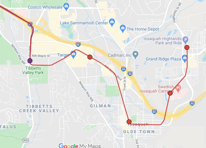
First stop: Gilman at 7th Ave NW and NW Gilman Blvd. Gilman Station builds upon the City of Issaquah’s plans (Central Issaquah Plan) for the area around the station to be part of Issaquah Valley, the city’s new mixed-use urban core. The City is working to zone the surrounding area as higher-density, mixed-use development. Light rail works in perfect harmony with that dense development: residents can enjoy a more walkable immediate neighborhood while light rail connects them with destinations further afield so they can ditch cars altogether. The key here is access: optimally, transit should be located within a half mile of all residents; this holds especially true in a car-dominated suburb like Issaquah where easy access to transit needs to be seriously considered in order to get residents out of their cars. Hence, Gilman Station can work together with Central Issaquah Station (about a mile away) to improve accessibility and promote denser, transit-oriented development (TOD).
The benefits of transit-oriented development are massive. TOD disincentivizes driving, thereby reducing greenhouse gas emissions and boosting air quality. TOD’s walkable neighborhoods also encourage healthier lifestyles. Likewise, the emphasis on transit benefits lower-income households, improving their access to economic opportunity. The City of Issaquah is working with developers to integrate affordable housing with redevelopment plans; transit and light rail will play a key role in building that equity. And as plans for light rail begin to materialize, developers might see more incentive in developing even higher-density buildings. A handy pedestrian bridge across I-90 can connect light rail with Costco’s growing international headquarters; other employers might also be attracted by light rail’s regional connections. The development might very well play out similar to that of the neighboring Spring District.
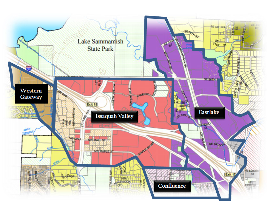
Next stop: Olde Town, near Front St N and E Sunset Way. Olde Town predates the suburban sprawl that forms much of the rest of Issaquah and is the historical center of the city. It boasts a charming collection of historic small businesses and cultural institutions. Here, light rail can greatly improve local and regional car-free access to popular destinations such as the city hall, salmon hatchery, courthouse, and parks. As the city aims to preserve the neighborhood’s nature and small-town feel, light rail provides a helpful alternative to more parking. And as per the city’s aims, streets can be restructured for bike lanes and additional greenery as light rail reduces vehicle traffic.
The City has also opened the possibility of some private redevelopment of some of Olde Town provided that it adheres to some design guidelines. Arguably, many buildings on Front Street can be artfully redeveloped to preserve the neighborhood’s character, while the clean street grid is a source of potential for that redevelopment to be walkable and transit-oriented. The myriad of beautiful trails nearby will certainly benefit new residents and can be enjoyed by more people once connected by transit.
Conveniently, there is already a disused section of railway that can be converted for light rail use to connect Olde Town Station with Gilman Station; it runs from Olde Town Station to the NW Gilman Blvd, where it can link onto the aforementioned (proposed) viaduct and then to Gilman Station. The railway will need to be widened into two tracks but there seems to be enough room in Rainier Blvd right-of-way that parallels the railway to do so (as to not use eminent domain).
Last stop (for now): Issaquah Highlands. There will be two stations: one adjacent to the Swedish Hospital and another in the commercial center at the existing Issaquah Highlands Park-and-ride. Now, although the Purple Line’s terminus is a [dreaded] parking lot, this particular one fills up quickly: King County Metro warns us that it’s usually filled 90% or above by 9am on weekdays. Just to clear things up, we will not be expanding the lot from its current 1010 spaces. The main issue for transport to and from the Issaquah Highlands in the future will likely not be the capacity of the park-and-ride but rather the clogged I-90 freeway and the lack of frequent routes. Currently, King County Metro plans for only one frequent route by 2041 to the Highlands and the (currently) proposed Purple Line ends miles away at Issaquah Transit Center. Today, there is only one route that serves the Highlands on Sunday: Sound Transit’s 554, at a 30-minute frequency.
That overall lack of usable transit options in the Highlands will arguably stifle car-free development there in the future. We can already see that much of the commercial core of the Highlands is covered by parking–we don’t want that trend to continue. And while single-family homes currently make the bulk of housing stock, there is a desire for denser townhomes and mixed-use development. By building light rail to the Highlands, we can take advantage of some of its existing walkability and development potential.
Light rail is a perfect complement to the hundreds of planned apartment units, as well as the hospital, apartments, townhomes, homes, and myriad of commercial space already built. With transit, developers might see incentive to transform existing parking lots to denser, mixed-use buildings. The City of Issaquah has also promised to be good partners with transit and upzone near stations. But without significant transit improvements, it’s unlikely that the Highlands’ true car-free potential could be realized.
From Olde Town Station to Issaquah Highlands, the Purple line can run east at-grade on E Sunset Way until near 5th Ave SE where it elevates onto a viaduct to tackle the steep grade onto the Highlands.
By directly serving key destinations where people want to go, the Purple Link extension can truly give Issaquah residents a car-free way around town. I-90 and the Sammamish Plateau (which the Highlands is located on) serve as natural barriers to walkability that light rail can help break down. Light Rail can unite the different developing regions of Issaquah into one connected whole. And Seattle, along with the rest of the Eastside, will be just a short ride away.
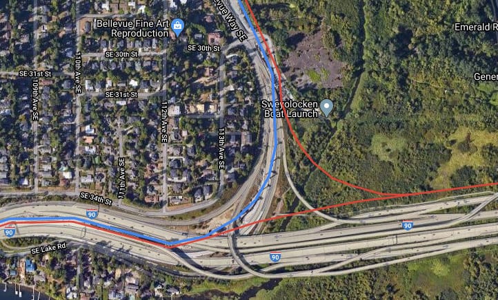
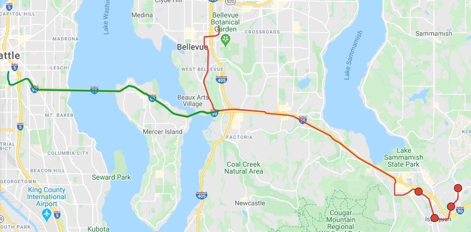
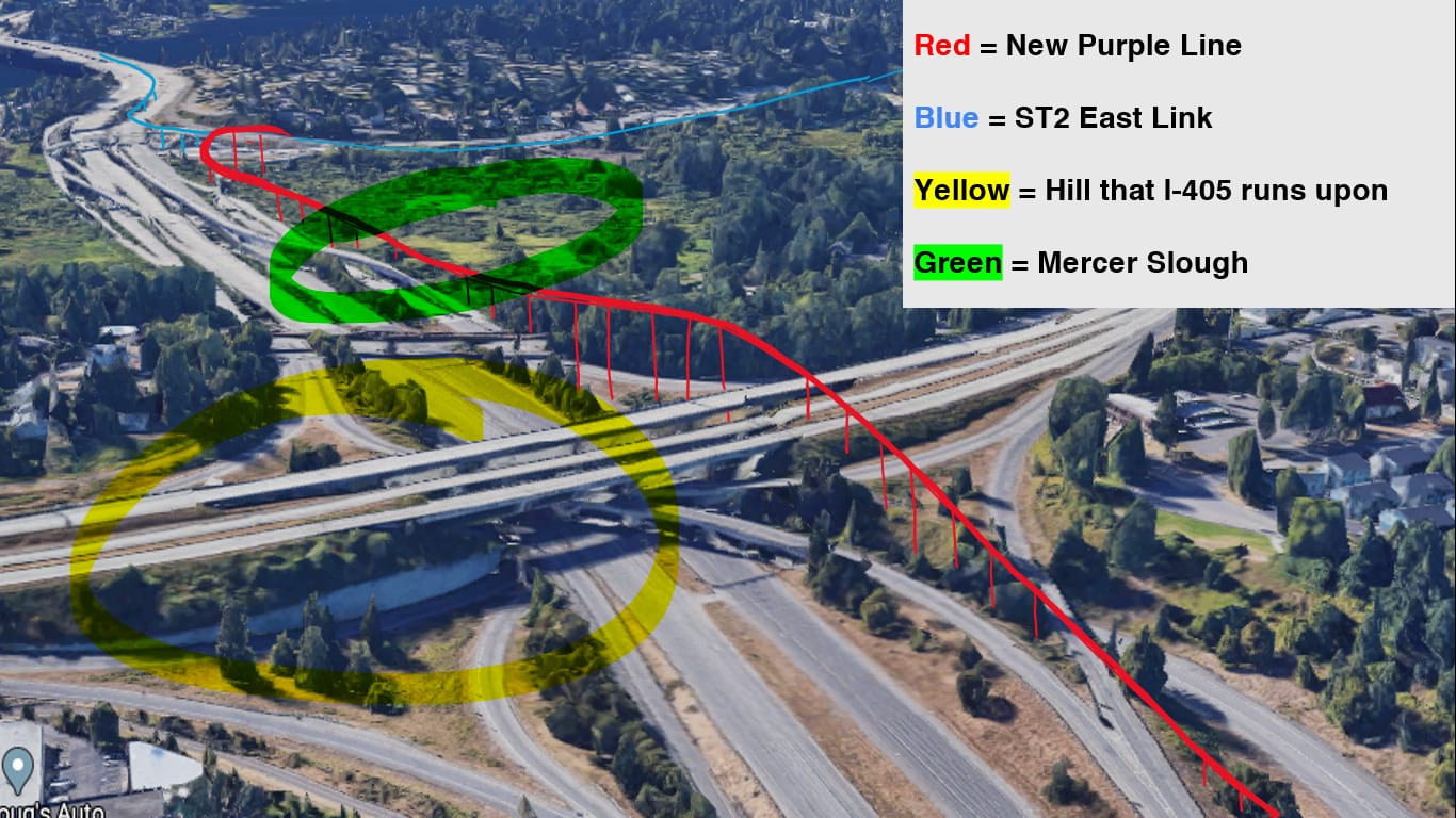
That short ride going west would be on the already-approved portion of Purple Line along I-90 to Factoria. There’s little retooling needed for this section here; I-90 provides the quickest and most direct route. The point of contention comes at the connection between Richards Road and East Main. The currently-proposed option is for Purple Line to turn north just west of Richards Road Station and follow I-405 to East Main Station. A better option, however, would be for Purple Line to instead continue due west along I-90 and connect directly to the East Link tracks at Bellevue Way (see picture below). There, Purple Line can turn north and connect to the existing East Link tracks from South Bellevue to Wilburton that it will follow to serve the same stations as originally planned with one addition that is South Bellevue.
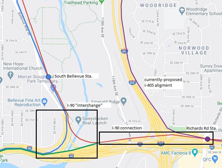
Perhaps the biggest advantage of this I-90 connection from Richards Road is that it also allows for a future light rail line between Seattle and Issaquah. The Purple Line can connect to East Link in both directions in an “interchange” over I-90: north to Kirkland and west to Seattle.
This Seattle-Issaquah “Magenta” line has many justifications, a few being that it can become part of the regional light rail spine and that it can largely replace many existing Seattle-Issaquah bus routes. These routes include King County Metro’s peak-only 212, 214, 216, 217, 218, and 219, and Sound Transit’s all-day 554. The Metro routes see a combined 7,100 riders per weekday and the 554 sees 4,170 for a grand total of 11,270 riders in all–a massive number for a city with a population around 40,000. The revised Seattle-Issaquah Purple Line will serve more riders than the currently-proposed one, which Sound Transit’s preliminary estimate pegged at 8,000 to 10,000 daily riders. Factoring in Issaquah’s expected population growth, ridership could be quite substantial.
There are a few differences in the termini of the bus routes, for example, the 217 serves some extra stops around Eastgate and the 216 continues past Issaquah Highlands to Sammamish. While light rail won’t be able to serve every bus stop, local feeder bus routes will continue to exist and last-mile transport options like Via to Transit could fill in the gaps.
Sure, if we build the currently-proposed Purple Line, riders can still travel from Seattle to Issaquah on light rail, but it will require potentially tens of thousands of riders to not only transfer from East Link but also make a four-mile detour in doing so. And seeing as the currently-proposed Purple Line does not serve the Issaquah Highlands and other urban centers, the East Link transfer may not even be the only one riders will need to make. Alas, such complications may very well push current and prospective riders back into their cars.
That’s why it’s crucial to build at least the I-90 connection under ST3 instead of the currently-proposed alignment along I-405. If we stuck with current plans and built the latter, it would accommodate the Purple Line but not the Seattle-Issaquah Magenta Line. If we were to build the much-needed Magenta Line later on, we would likely have to build the I-90 connection anyway. So why not kill two birds with one stone and just build the I-90 connection that can accommodate both lines now? We don’t even need to completely build the I-90 “interchange” under ST3; it could be built in phases with the Magenta Line portions being built in a later ballot measure.
The potential big barrier to building the East Link connection as it will likely require a very tall and long bridge to be built over I-405 and Mercer Slough. Design and cost constraints may be prohibitive to its construction. The Issaquah extension will also inevitably result in a rise in cost; the extension requires some land acquisition and extensive viaduct construction over challenging terrain.
The buses running Seattle-Issaquah and Seattle-Eastgate routes already run at six-minute headways at peak and suffer from frequent delays, yet many are still crammed to the brim with riders. Can Seattle’s congested streets handle even more buses? We need an efficient Seattle-Issaquah light rail that serves Issaquah’s growing urban centers moving forward; our current ST3 plans are simply not enough. Now simply isn’t the time to cut corners.
While cost inevitably poses to be a great barrier to any transit project, there is light at the end of the tunnel. A 2014 study by the American Public Transportation Association found that, for each dollar spent on transit, cities experience $4 in economic returns. And this isn’t even considering the priceless societal benefits transit brings, such as reduced air pollution, increased equity, and better overall quality of life. In a quickly developing region like Issaquah, the economic and societal benefits could be even greater. All in all, the new Purple and Magenta Lines might very well pay for themselves and then some in the long run.
We still have time to design a Purple Line and a light rail system that puts people before parking. The Eastside is about to have a chance to put cars in its rearview mirror; let’s embrace it and complete it with light rail. Purple Line will move us all forward.
Editor’s note: This article originally appeared under the pseudonym byline Hyra Zhang. Brandon Zuo is the same author.
East Link Is Starting to Look Like a Light Rail Line as Construction Progresses