So, why do cities cling to highways in residential areas?
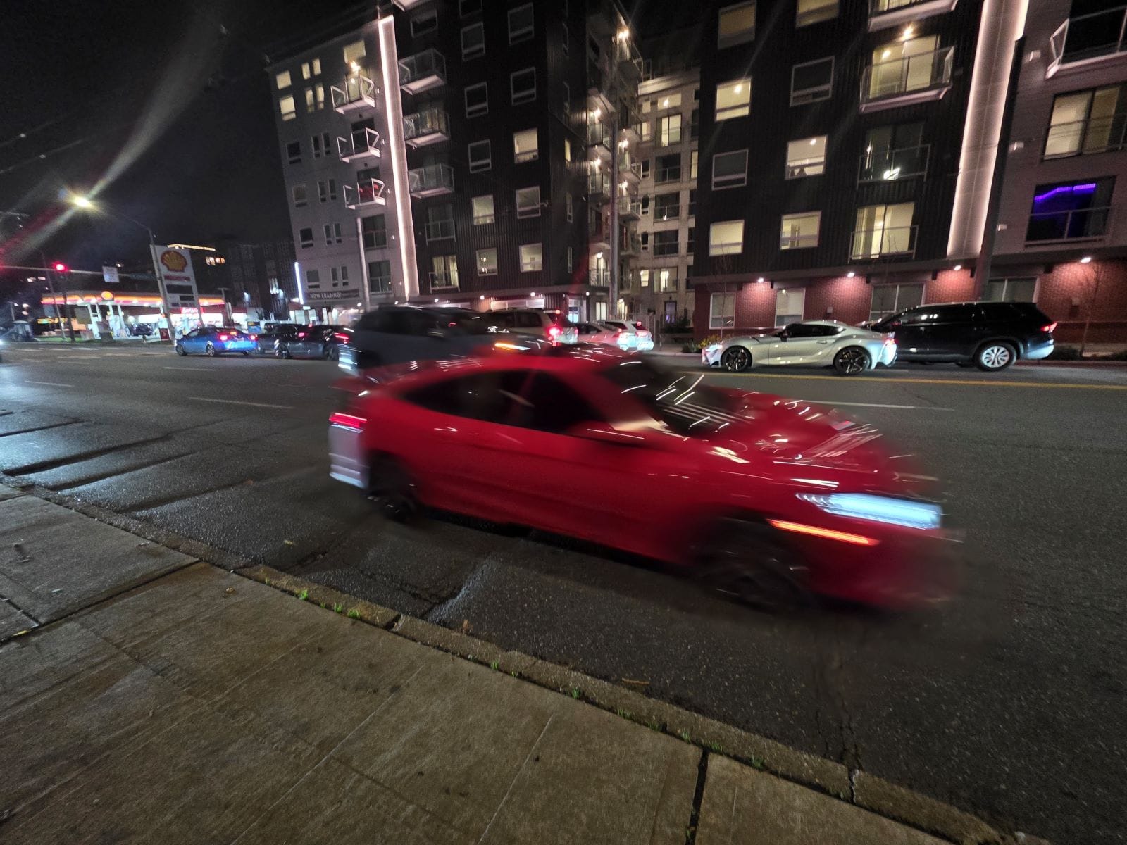
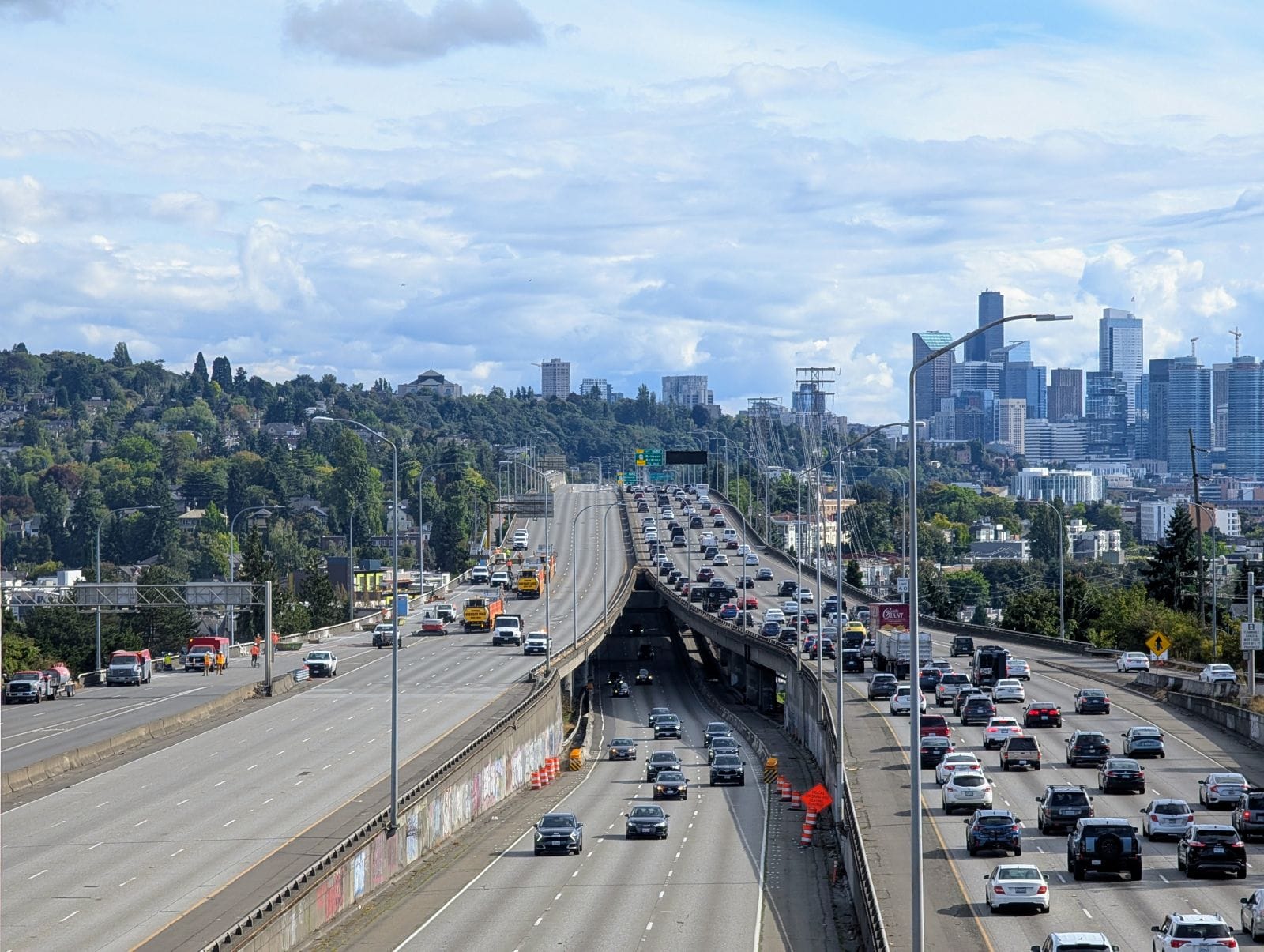
Highways have a profound impact on the health and wellbeing of our city. If you think about a part of Seattle that is particularly unsafe and hostile to pedestrians, it’s probably adjacent to highway infrastructure. Not only is this infrastructure unsafe and unpleasant to live next to because of air and noise pollution, urban highways actively make it harder for transit to compete with the time it takes to get somewhere driving.
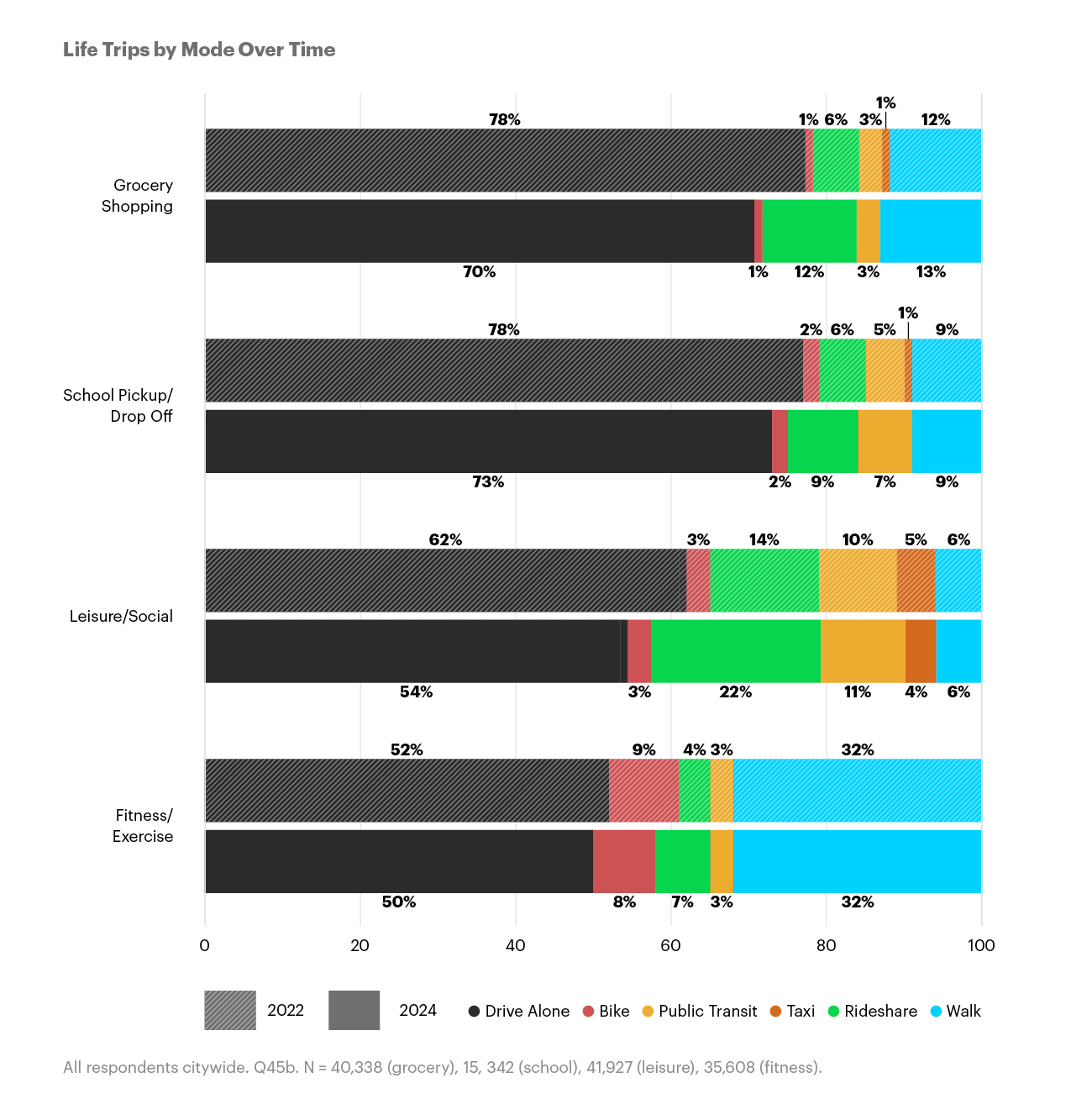
Take, for example, my weekly trip from Rainier Valley to bring my kid to language classes near Northgate. Best case scenario, If we were to bike to and from the nearest light rail station, it’s a one-hour-and-15-minute trip. Driving would take 20 minutes. This disparity is why Seattleites drive for most non-commute trips.
Despite our relatively extensive and frequent transit access, our urban freeways make driving almost always faster. When Commute Seattle’s Survey respondents were asked why they drive alone, the top response was: “It makes my trip significantly shorter.” One of the reasons Canada has higher transit ridership in all their cities than the U.S. is that they didn’t build urban highways to the extent we did. Transit remains more competitive.
What do I mean by “urban highways” in the context of Seattle? In this definition, I’d include I-5 and I-90, as well as state routes like SR 99 (Aurora Avenue), SR 522 (Lake City Way), and SR 513 (Sandpoint Way). City-owned routes that restrict crossings to speed car traffic also function as urban highways: this would include the West Seattle high bridge Spokane Street Viaduct, and 15th Avenue NW in Ballard.
I’d go as far as to include some of our legacy state highways as well — like Rainier Avenue, which includes many quarter-mile long stretches between traffic signals, encouraging higher driving speeds and more crashes for pedestrians, bikers, and drivers alike.
So what can we do? First off, as Kadie Bell Sata suggested in her recent Urbanist op-ed, “The multi-year maintenance project known as Revive I-5 should have been a once-in-a-generation opportunity to shift trips away from single-occupancy vehicles and toward transit, walking, rolling, and biking.” As Bell Sata suggests, it’s not too late. There’s still time for our city to use these closures as an opportunity, but it will require clear leadership and focus.
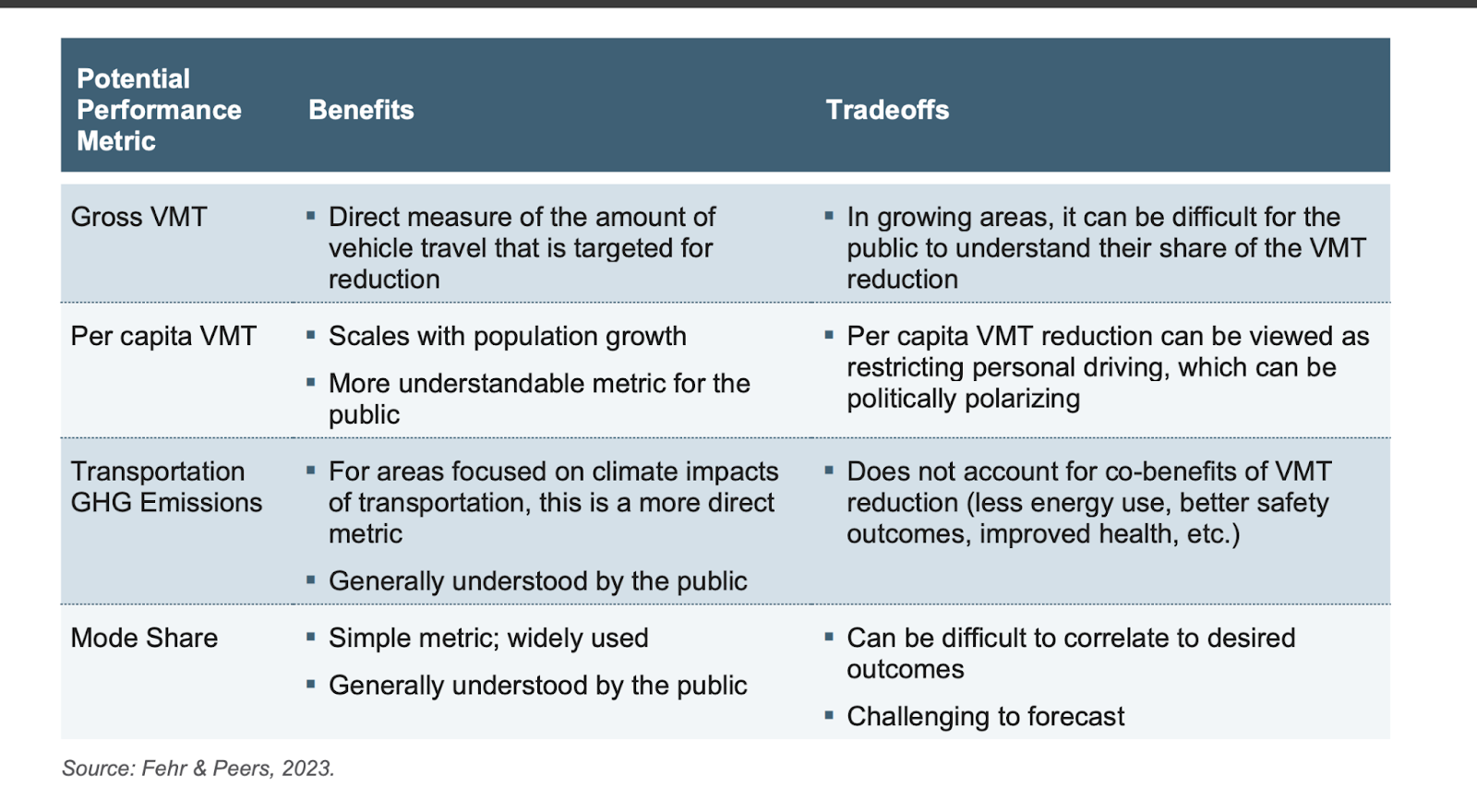
The city of Seattle needs a clear mayoral directive that ensures that every project that touches our city encourages a mode shift away from single occupancy car trips and reduces gross (not just per capita) vehicle miles travelled (VMT). This needs to include City of Seattle projects, which must be required to demonstrate how they reduce VMT, and projects where city streets and state highways meet.
In 2008, Washington State set a goal to reduce per capita VMT by 50% by 2050. This was followed by a report released 2023 that looked at strategies for how our state could meet these targets (the only time we did was during the first year or so of the pandemic). Unfortunately, since the report was released, there’s been little forward momentum and insufficient funding for meaningful VMT reduction work.
HB 2134, which died in this legislative session, was a step in the right direction, giving Regional Transportation Planning Organizations in some of our more populated regions the ability to monitor the plans of local jurisdictions to ensure they are working towards meeting carbon pollution and VMT reduction targets.
We’ve all seen plenty of well-intentioned climate, transportation and public health policies that look good on paper, but lack the political will or structure for implementation. For example, the Seattle Department of Transportation (SDOT) released the Climate Change Response Framework in 2023 , which set the goal to reduce the number of vehicle trips that use an internal combustion engine from 65% to 35% by 2030. We are nowhere near meeting that target, nor the projected increases for the percentage of transit, walking and biking trips defined in the SDOT framework.
Re-allocating street space is a powerful tool that can be unlocked with a mandate to reduce VMT. But without a well-designed and implemented mandate, projects that maintain the status quo will continue to coast through our planning process.
Here’s an example of how that works: a WSDOT-led Judkins Park workgroup planning a ramp reconfiguration design for I-90 and Rainier got stuck debating whether we could reduce the number of general purpose lanes on Rainier Avenue S. Seattle’s Comprehensive Plan cites 2045 Puget Sound Regional Council traffic projections that show that while projected population for the area increases and the percentage of car trips is reduced, the total volume of car trips will not decrease.
Because of these projections, which are codified in our comp plan, WSDOT was arguing for the need to maintain all six lanes. As of February 5, WSDOT seems to be walking back from this assertion after models show that, with both current and reduced traffic volumes, four lanes should be sufficient.
What’s clear from this process is that we’re designing our streets backwards. The expectation that we must move the same or more cars through this burgeoning area limits the possibilities of what is feasible for a redesign. Sound Transit is opening a new light rail station and developers are building dense housing around it. Instead of a design that prioritizes how the station area will grow into a community where people want to spend time, we are designing for anticipated car volumes.
If we design a road for current car volumes, we are inducing those volumes to exist, and we’re actively working against our mode shift goals. Add a lane, and it will quickly fill with cars. Only by designing for reduced car capacity can we manifest a reduction in car volume. And only when we design for less car volume can we improve the experience of movement for everyone outside of vehicles.
Fundamentally, we can’t ignore the context in which urban highways were built: often with the explicit intention of displacing non-White and low-income communities. Preserving infrastructure that maintains the current volumes of trucks and cars only perpetuates the public health costs of automobiles in cities, costs that continue to be disproportionately borne by low-income, non-White and immigrant residents. As communities across the U.S. are starting to take steps to address these harms, Seattle can be a leader in this space.
In addition to a directive to reduce vehicle miles traveled, our mayor should convene a project team to take the lead on highway mitigation projects. We need safer and more frequent crossings on Lake City Way in North Seattle, safer and more comfortable crossings of the I-5 ramps at the 45th Street in the U District, and on Albro street in Georgetown. And we need to reconnect South Park by removing Highway 99 and rebuild Aurora Avenue to prioritize local, non-car movement.
All of these will run into the same barrier we’ve encountered with the Judkins Park work: if vehicle volumes are to be maintained, then vehicle throughput has to be maintained, meaning our options to remove slip lanes, ban right turns on red or reduce the number of travel lanes won’t be allowed.
Highway lids are one tactic, and do decidedly make communities adjacent to highways less awful (my kid is fortunate, as advocates in the 1980s fought for a lid on I-90 in Judkins Park; his school sits on the lid instead of next to the freeway.) But lids are the proverbial band aid. By allowing the same volume of cars (and often more cars, as we saw in the Rose Corridor Project in Portland) to travel through the area, all the other harms of vehicle miles travelled still accrue.
As Allison Sant notes in a recent Bloomberg CityLab piece about urban highways in New York: “While capping can have positive impacts in local communities, it will not limit the number of vehicles flowing through the neighborhood or fully mitigate their effects.”
We have to tackle the public health harms that vehicles themselves create. Only then will we be able to have a city with vibrant public spaces and a robust transit network that everyone uses. That means mandating that all road projects must be designed to reduce the overall volume of car trips through and in our communities.
With a clear mayoral directive around achieving our VMT reduction goals, we can start looking seriously at other policies that would help us reach our targets. Where should we create bus-only lanes and traffic diverters to make transit, walking, riding and rolling more appealing travel options? Where can we pedestrianize public spaces, creating play streets and places for all of us to connect with our neighbors, especially in neighborhoods that are being upzoned to include more people?