Transit App is making another leap forward in the world of real-time arrival information. The software already plugs into real-time transit data where available, but its lacking in many places, in part due to transit agencies hoarding their data (hey, Community Transit!) but also because it may not exist at all. That’s left Transit App with only one option: scheduled data as a fallback. In Transit App’s own backyard of Montréal, real-time data is almost non-existent across the whole metropolitan region.
But even when there is real-time data, it may not be perfect. In many places, real-time data can be spotty: channeled for some routes and none for others. Or low frequencies of data getting communicated from vehicles leads to inaccurate arrival times when traffic snarls up, as it is wont to do in Seattle.
The techies at Transit App, however, have worked up a new solution that could not only serve as a patch for scheduled data scenarios, but also improve the overall quality of real-time data in absolute terms. That’s where crowdsourced real-time arrival data comes into play. Earlier in the fall, Transit App launched a new navigation feature called “GO”. The feature works a lot like any other navigation system (e.g., Google Maps, TomTom, and Wayze) on the market, except that it is tuned in specifically for transit and has a few more bells and whistles.
Transit App 4.0: Transit Navigation Revolutionized
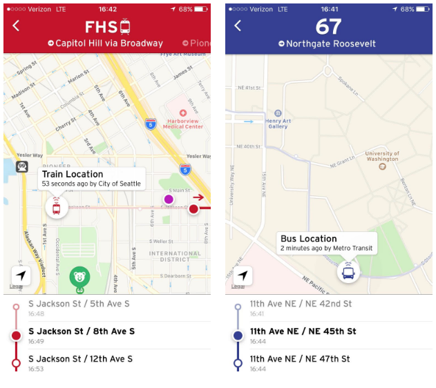
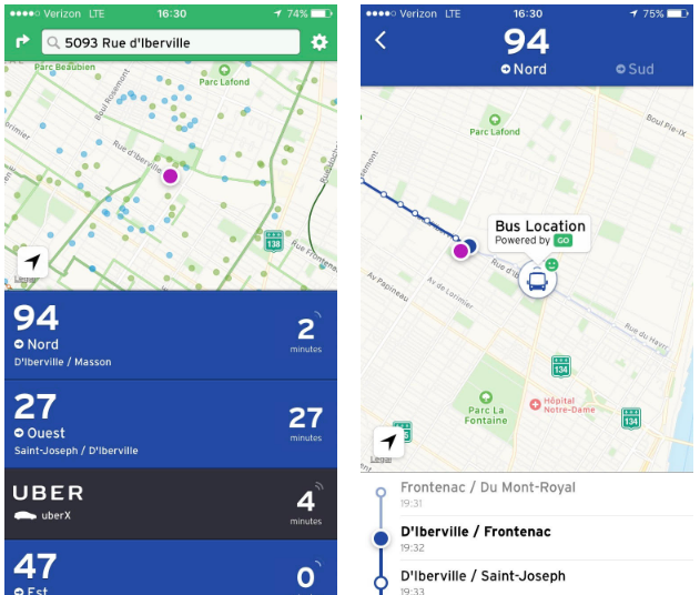
When the GO feature is activated, a user’s location is tracked precisely on the app map and calculates the time to arrival at the user’s intended destination. The user also provides Transit App with data about the specific trip, which includes the location of the vehicle location. In other words, whenever a user is using GO, they are helping to crowdsource real-time data, which can be leveraged by the Transit App system to better inform other users about where a vehicle is and when it might arrive–at least if it works according to plan.
So far, Transit App has released the crowdsourced real-time arrival feature in Montréal and Victoria, but it will slowly roll out to other metropolitan areas. In speaking with Transit App staff on the topic, The Urbanist was told that there is no firm timeline for roll out of the feature in the Puget Sound. But Transit App staff noted that it is high on the list since real-time arrival data–which is active for many Puget Sound services–is somewhat spotty.
Convergence of Forthcoming Real-Time Data Improvements in the Puget Sound Will Be a Boon
In an article that appeared on Seattle Transit Blog this week, Martin Duke broke the news that Sound Transit will release real-time data for Link trains next month, something that riders have long requested from the agency. But Duke also noted that the reader boards installed at many Link stations won’t get the benefit of the new real-time feeds anytime soon:
First, the good news: beginning sometime in January 2017, OneBusAway (and any other application using the data feed) will display actual next train times for OneBusAway [(OBA)]. Not only will mobile devices have accurate information, ST’s IT department says that a software upgrade last September “improved the accuracy of the ETA data” for Capitol Hill and UW Stations.
Unfortunately, there is no clear path to upgrading the other existing stations. The existing “dynamic” screens are severely limited and cannot accept the heavily processed data feed that OBA uses. The study estimated the total cost of replacing the screens at $475,000, which ST deemed “prohibitive.” Blocked there, ST is looking at a “feasibility study” that will figure out what can be done with the existing system, how much it will cost, and funding sources for the work.
While the Sound Transit solution is imperfect, it will be a boon to riders with mobile devices. Riders who have mobile service will get the benefit of real-time data for Link trains both above and below ground. That’s because Sound Transit has deployed mobile service throughout the transit tunnels stretching from the Pioneer Square/International District Station to University of Washington Station, and next year the same mobile service will be added to the Beacon Hill tunnel. For other riders without a mobile service but with a device that has wireless connectivity, there is the option of using WiFi at each of the station platforms in the Downtown Seattle Transit Tunnel, a service that Metro rolled out earlier this year.
This is all good news because transit riders will be able to further benefit from platforms like Transit App that can translate the real-time data into a usable product. If Transit App’s crowdsourced real-time data can deliver as promised, riders may have a better idea than ever when an inbound bus or Link train is due.