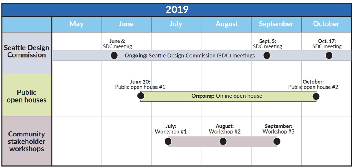
The Washington State Department of Transportation (WSDOT) is seeking community feedback through its SR-520 Online Open House. A series of community workshops will also run through Fall of 2019.
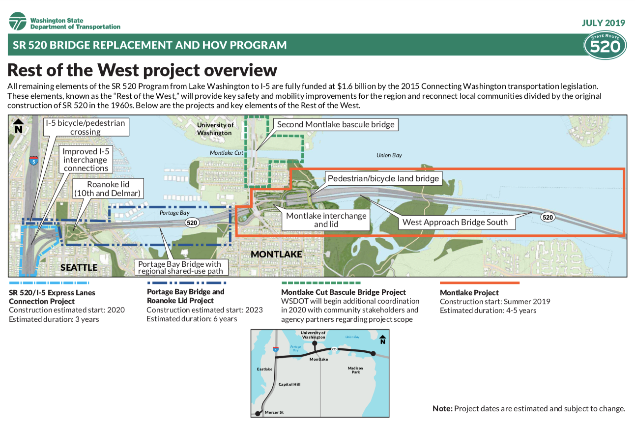
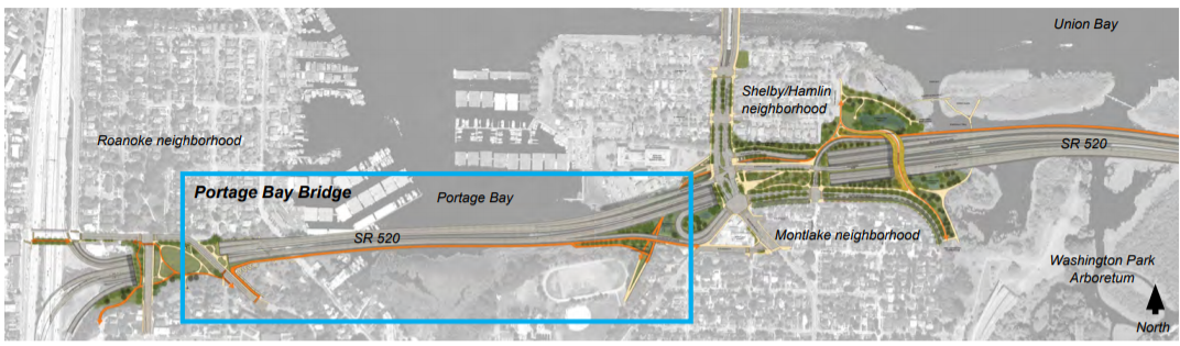
As project crews prepare to break ground this summer on the Montlake Project elements of Rest of the West, the continuation of WSDOT’s multibillion dollar remake of SR-520 between Seattle and the Eastside, the agency is beginning community outreach on its design plans for a new Portage Bay Bridge and Roanoke highway lid.
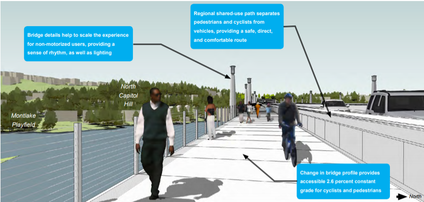
Like the Montlake Project elements of Rest of the West, the new Portage Bay Bridge and Roanoke highway lid are planned to build highway traffic capacity while adding new multimodal connections. The new widened bridge will include the final SR-520 stretch of dedicated transit/high occupancy vehicle (HOV) lanes in each direction. These lanes have been designed run from South Lake Union to Redmond, connecting two technology job centers. It will also expand the regional shared use path that runs along the entire SR 520 corridor. A new 30-foot-wide shared-use crossing over I-5 is also planned, along with bicycle and pedestrian connections that will run through the Roanoke lid that will cover the highway beneath 10th and Delmar.
A project with a complicated past
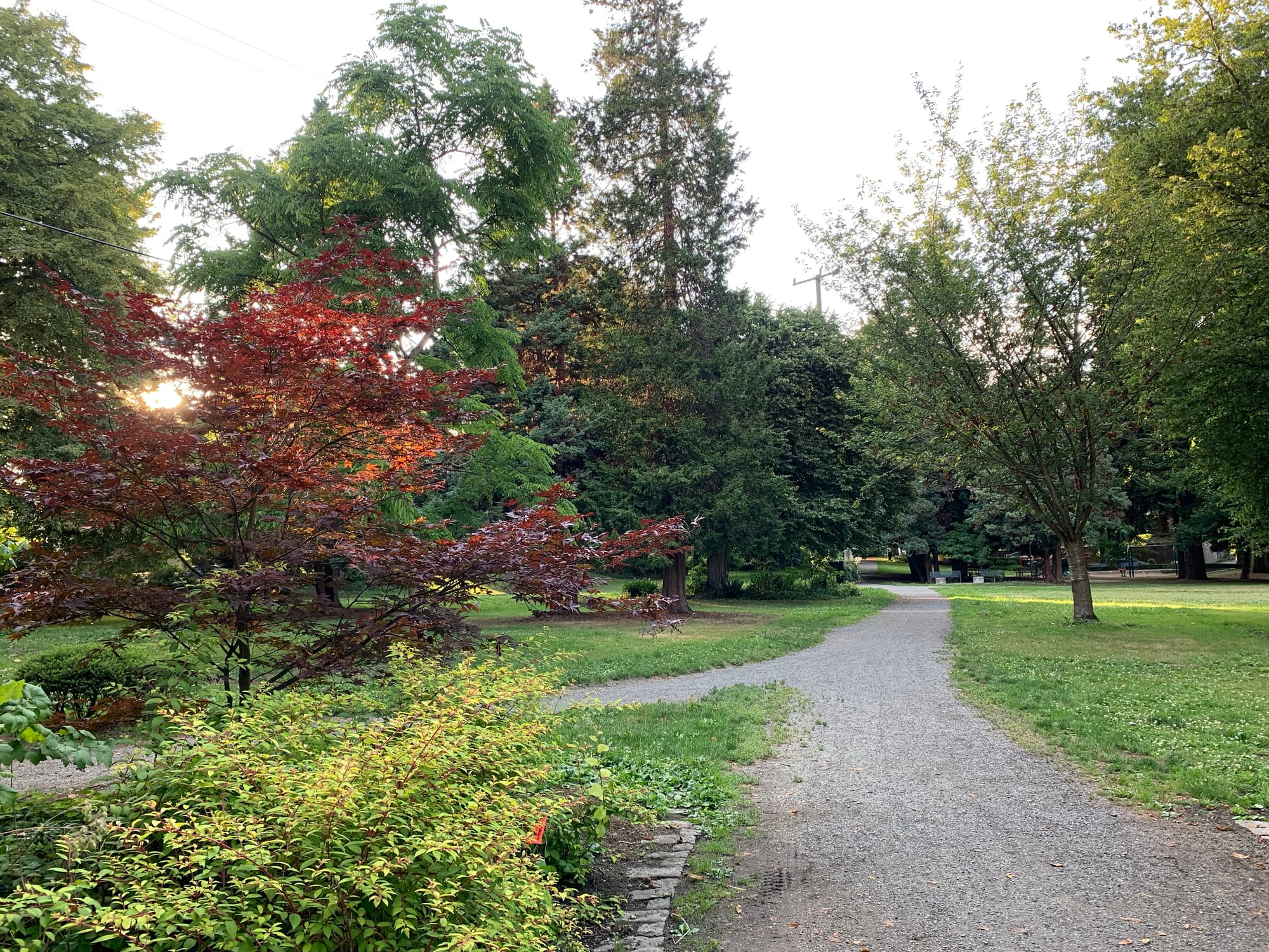
Long before the North Capitol and Montlake neighborhoods came to be dominated by the SR-520 highway, the area was designed around streetcars and bicycles. This early urban design legacy is discernible today through the small business district at 10th Avenue and E Roanoke Street, which was on the route of the Broadway streetcar line, and the lush winding paths of Interlaken Park, initially designed as a bicycle boulevard.

In the 1950’s when the Washington State Legislature approved a plan to construct a second Lake Washington bridge that would connect through Montlake, neighborhood groups expressed concern about how the route would impact surrounding neighborhoods and nearby Washington Park Arboretum. While public opposition delayed the project by six years, the Montlake-Evergreen Point route was opened as the SR-520 bridge in 1962. The large freeway footprint created by both on-ramps and widened roadways that connect SR-520 to I-5 (completed in 1963) devastated the surrounding natural and urban environment.

Neighborhood history laid out on Washington State History Link suggests the freeways were very destructive to the urban fabric.
Nearby neighbors lived through the violent truncation of city streets, prodigious loss of housing stock, a multi-year multi-mile construction site, and… road noise, street congestion, and pollution that increased decade by decade.
Large gracious homes that had faced similar neighbors across peaceful streets were now survivors, their residents peering through front windows at freeway traffic or, later, towering concrete abatement walls. The freeway utterly and permanently altered the organic landform of ridge sloping down to water, slicing the narrow Eastlake neighborhood — the western third of the ridge — away from the rest.
Paula Becker, Seattle Neighborhoods: Portage Bay-Roanoke-North Capitol Hill — Thumbnail History
The Bagley viewpoint is the perfect location to take in the effects of highway construction on the surrounding area. Once the “gateway” to Interlaken Park, a turn of the nineteenth century design for Bagley viewpoint created by superstar landscape architects the Olmsted brothers imagined the connection to Interlaken as a grand concourse [that] included “walks, entrance gates, shelters, etc., including the steep slope down to Portage Bay.” The Olmsted’s plan went even further to imagine a boulevard network, dubbed “Volunteer Hill Parkway” that would run on the bluff west of 10th Avenue all the way to Volunteer Park.
For various reasons most of the plan was never realized, and today the Bagley viewpoint is hemmed in by the highway and a parking lot. However, a visit to Roanoke Park, also designed by the Olmsted brothers, offers a modest glimpse into a quieter and greener alternate history of the area.
Extensive community outreach
When it became clear a couple decades ago that the SR-520 highway infrastructure that slices through this section of North Capitol Hill would need to be replaced, WSDOT took a different approach this time around than it did in the first time around. According to the agency’s SR-520 Public outreach and events page, WSDOT has held 500 public events, including open houses, drop-in events, community design workshops, fairs and festivals, and community organization briefings.
Community participation in the design process has been ongoing since 2010 (and maybe earlier) when the first workgroups were convened to submit feedback on project concepts, and that community participation continues today with community stakeholder workshops and an online open house running through Fall of 2019.
Safer infrastructure and more mobility options
While the project’s big price tag and expanded highway footprint on the surrounding area, WSDOT’s plans for the SR-520 corridor are improving safety and increasing options for pedestrians, cyclists, and transit riders. WSDOT says the Rest of the West’s benefits include:
- Safer travel from replacement of the old, structurally vulnerable west approach bridge and Portage Bay Bridge;
- Improved regional mobility with completion of the final SR-520 stretch of dedicated transit/high occupancy vehicle (HOV) lanes, in each direction, between Redmond and I-5;
- Greater transportation options from a completed regional bicycle and pedestrian trail along the entire SR-520 corridor, and a new, 30-foot-wide shared-use crossing over I-5;
- A community-connecting highway lid between 10th Avenue East and Delmar Drive East, with landscaped open space;
- Improved water quality from a new system for treating SR-520 stormwater runoff; and
- Fewer traffic backups from wider highway shoulders that allow disabled vehicles to pull over without blocking traffic.
At the July 11th community stakeholder workshop, it was clear that participants were enthusiastic about the prospect of improving connections to the SR-520 multi-use trail and increasing green space in the community in the form of a highway lid park.
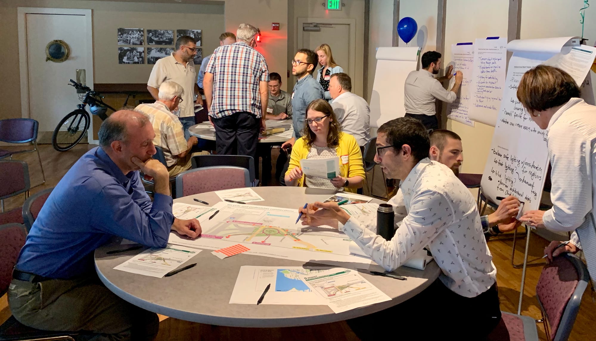
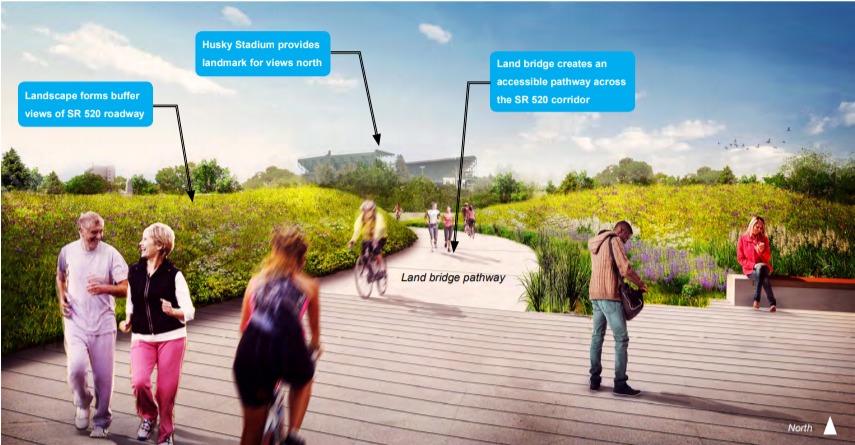
Most of the participants’ questions and concerns centered on how to improve connections between the SR-520 multi-use trail and the surrounding streets. Participants were also eager to learn more about WSDOT’s plans for the three-acre lid park, which will be owned by WSDOT but managed by Seattle Parks and Recreation.
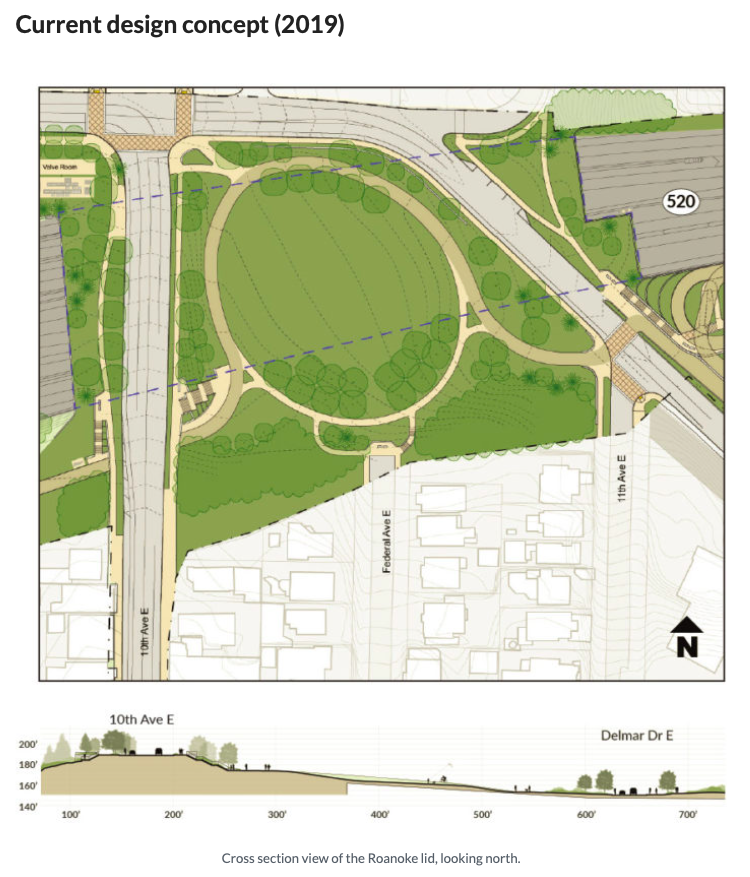
Current plans for the Roanoke lid park are for a walking and cycling trail to encircle an open green space. Strategic use of viewpoints throughout the site are intended to help activate the park and increase the “eyes on the trail.” The Roanoke lid park will connect to SR-520 multi-use trail, Roanoke Park, the planned pedestrian and cyclist bridge over I-5, and a potential greenway on Federal Avenue. As a result, the many different users (operating at many different speeds) will be moving through the park, and the design will need to ensure that all future users feel will safe and comfortable. Steep topography presents a challenge in the area, particularly around the topic of creating ADA accessible connections.
Stakeholders have already voiced opinions about adding a picnicking area on the lid park near 10th Avenue to complement the business district, as well as concerns about pedestrian access on the north side of E Roanoke Street. Future meetings will focus on multi-use trail accessibility, neighborhood connections, Portage Bay Bridge concerns, and more.
If you are interested in participating in a community stakeholder workshop or would like to keep informed about the Rest of the West project, send an email to the SR-520 Program at sr520bridge@wsdot.wa.gov. For registration purposes, please include your name, organization (if applicable), email address, and phone number.