The City of Edmonds introduced Stage Two of their Highway 99 Gateway and Revitalization project on Tuesday, which will begin construction improvements described in the Stage One planning project. This sequence began with the State Route 99 (SR-99) Subarea Plan, passed by the Edmonds City Council and covered by The Urbanist in 2017. The subarea plan aims to improve the land use and transportation environment of the corridor between 244th St SW to 212th St SW.
Stage Two of the project hopes to improve the overall safety of Edmond’s segment of SR-99 with proposed construction of raised center medians, and installation of a high intensity activity crosswalk (HAWK) signal. This is in response to two pedestrian deaths, 15 pedestrian injuries, and five bicyclist injuries along Edmonds’ stretch of SR-99 from 2017 to 2019. That works out to a high collision rate of 7.52 collisions per million miles traveled. The City has been working to improve pedestrian safety with improved signage on left turn opportunities like 224th and 238th in recent years, the package of proposed improvements go much further.
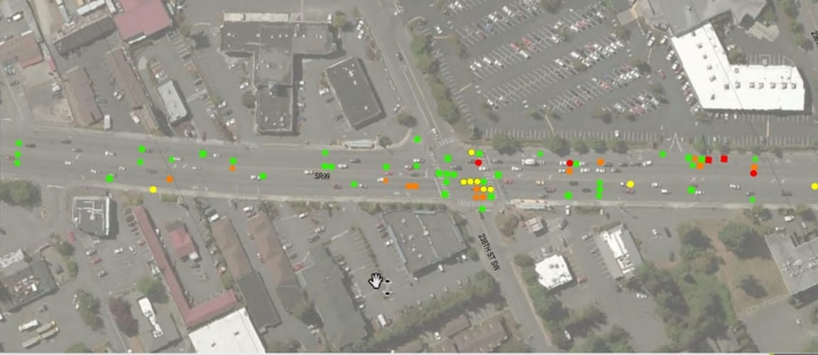
Proposed improvements
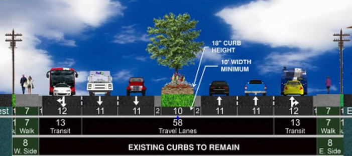
The most significant improvement proposed for this phase are raised landscaped medians along much of the corridor with mid-block left turn/U-turn pockets. The raised medians will replace a center, left turn lane that contributes to the collision-prone environment. They will also require lanes to be redrawn, as the medians will be taking a foot of width from the two outer lanes. The elevated medians will slim down to up to half-foot curbs where left turn/U-turn pockets are proposed.
The process also determined where left turns and U-turns are allowed on Edmonds’ portion of SR-99. They will be allowed in signalized and non-signalized intersections unless previously restricted. U-turns will not be allowed midblock if they’d conflict with left-turn lanes or through-movement queues, and will not be in places with significant crash history. The entire stretch is analyzed for potential left turn and U-turn feasibility in the City report.
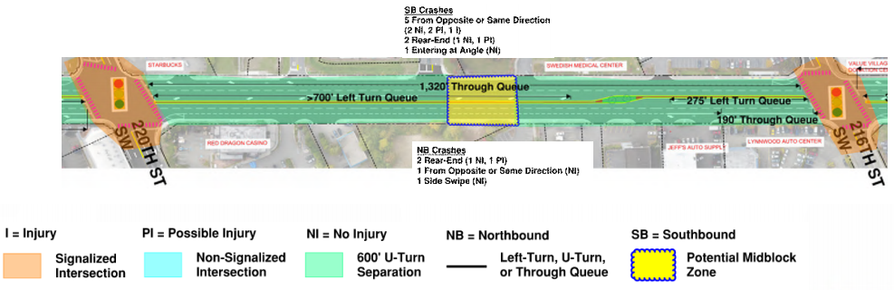
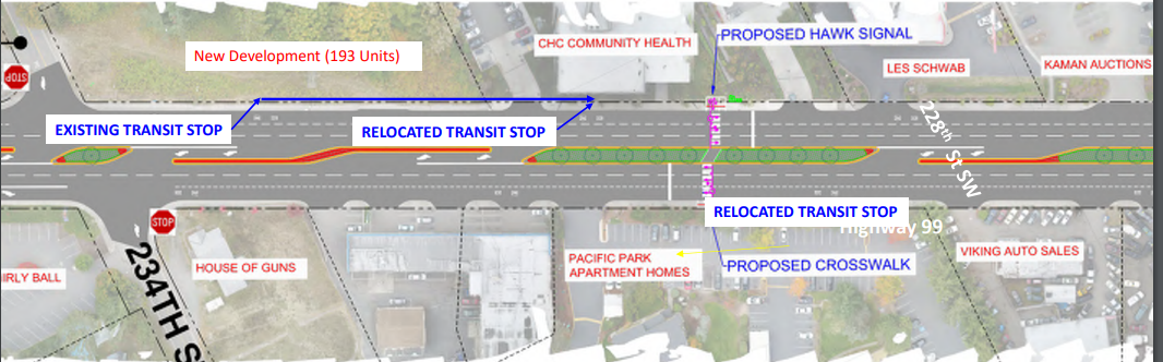
Proposed left turn and U-turn locations are at: 244th St SW, 240th St SW, 238th St SW, 236th St SW, 234th St SW, northbound into Community Health Center of Snohomish, southbound into Pacific Place Parents, 230th St SW, 228th St SW, 224th St SW, northbound into Doug’s Lynnwood Mazda, 220th St SW, 216th St SW, southbound into CarMax, and 212th St SW.
Between 234th St SW and 230th St SW, a HAWK signalized sidewalk is proposed. HAWK beacons are dark until activated by a person. When a person activates the signal, the beacon begins a sequence to alert incoming traffic of an intended crossing, and then allows people to cross after traffic is prompted to prepare to stop. The city will add a new active crossing for people walking, rolling, and biking to actuate. The new midblock crossing will also fill in a 0.7-mile gap between 238th St SW and 228th St SW where no crossing exists, and it will serve two relocated transit stops.
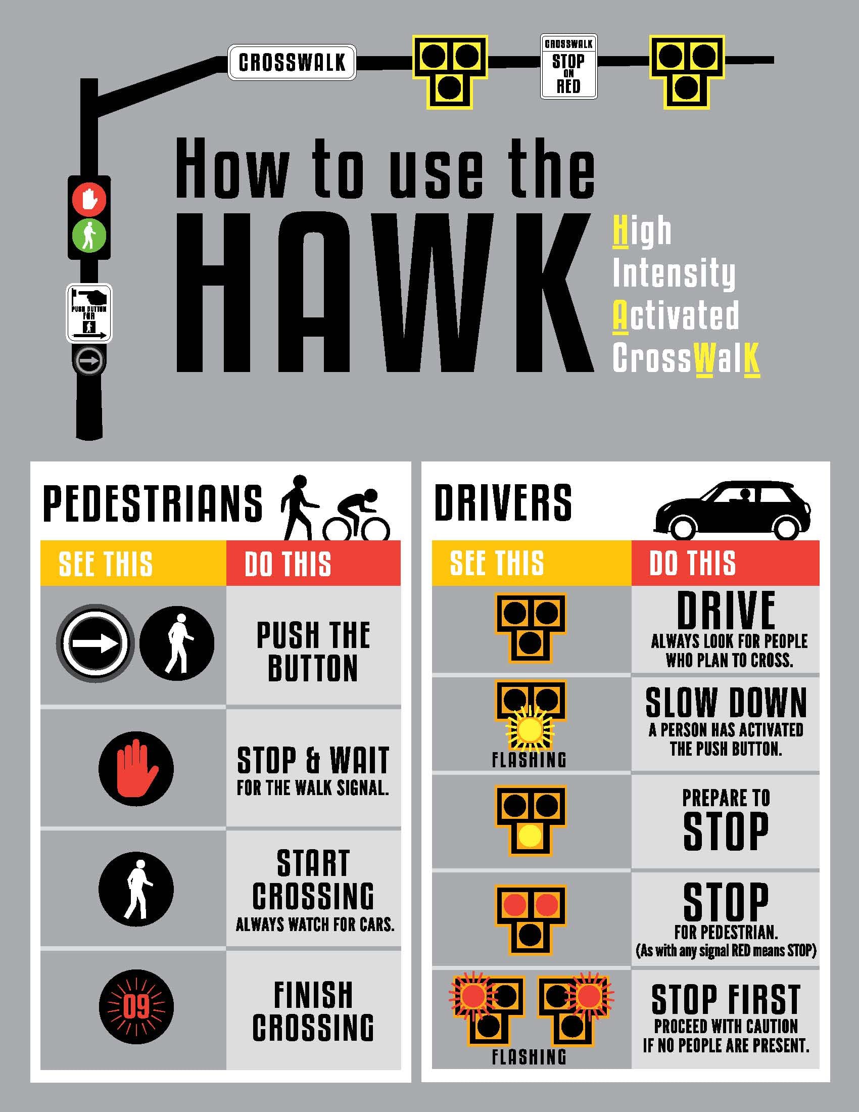
The jury is out though if a HAWK would be an effective tool at this location given the wide nature of SR-99 and speeds, behaviors of people driving, and general flaws of HAWKs. A simpler solution would be a half signal which could be activated for a full pedestrian crossing cycle. Edmonds councilmember Luke Distelhorst also presented a concern of other HAWK signals on SR-99 that are in Shoreline and use red-yellow-green light unlike the HAWK signal proposed on Edmonds’ segment of SR-99. The Edmonds Public Works Department responded with their preference for this signal, as it’ll be consistent with other HAWK signals in the city and that the Shoreline installations are considered pedestrian signals with three-section vehicle heads.
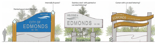
Lastly, Stage Two will begin some beautification efforts with new gateway signage at the northern and southern entry points to Edmonds, roughly at 212th St S and 244th St SW. This will be coordinated with a public taskforce and while it has not been designed at the time of the plans introduced to the city council, examples are shown.
What’s Next
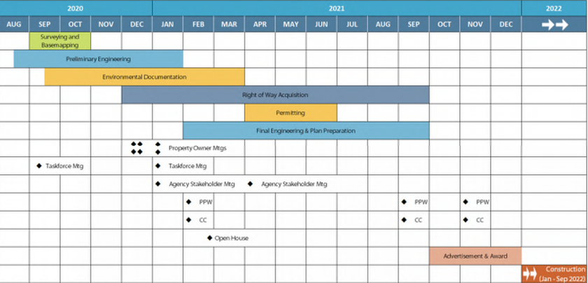
Planning of this stage of the SR-99 gateway and revitalization project is now just approaching the midway point. This month, the city just entered final engineering and plan preparation. If things go smoothly, expect construction to begin at the start of 2022 and complete sometime September 2022. (Meanwhile, the City of Seattle is lurching very slowly toward maybe redesigning its stretch of SR-99 despite a string of injury collisions and road deaths and rampant speeding that suggest a safety crisis.)
Past Stage Two, the scope of the greater project is planned to include wider replacement sidewalks, new street lights, landscaping and softscape treatments, and streetscape improvements. The city is also planning targeted utility replacements, potential undergrounding of overhead utilities, and better stormwater infrastructure.
Edmonds has published an SR-99 corridor overview at their website and will be hosting an online open house on February 25th from 5:30pm to 7pm. The proposals will go before the full council on February 16th.
Update: Comments from Councilmember Luke Distelhorst were added