For more than 20 years, residents of Georgetown and South Park have been advocating for a safer way to travel between the two neighborhoods. Thanks to the advocacy of neighborhood groups like Duwamish Valley Safe Streets, the Seattle City Council finally allocated $600,000 in 2018 to start design work on this connection. In 2020, they added another $5.2 million for construction, spurred on by the Move All Seattle Sustainably (MASS) Coalition that highlighted the ask in its transportation package.
A separated mixed-use trail was selected as the best option through a community process, and the route was narrowed down. Seattle Department of Transportation (SDOT) is currently designing the trail. In April, the agency presented their current early 30% design to the Seattle Design Commission. At this point, we have a pretty good idea of what each segment of the trail is going to look and feel like.
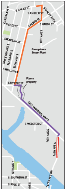
The trail’s northern segment in Georgetown will start on S Bailey Street, between 12th Avenue S and 13th Avenue S, near Georgetown’s Old City Hall building. 12th Avenue is a relatively low traffic street that would connect people directly to and from the Airport Way business district, but the trail won’t provide that connection directly, which would have been great to see.
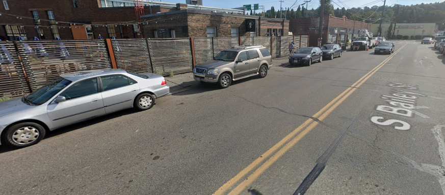
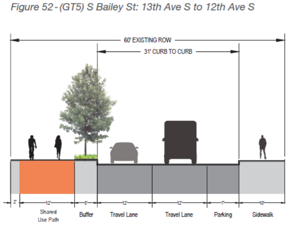
The design for the trail here is representative of the rest of the route in Georgetown: the sidewalk will be expanded to a consistent 12-foot shared use path with a five-foot buffer of trees and plantings. No improvements are planned on the sidewalk on the other side of the street from the trail.
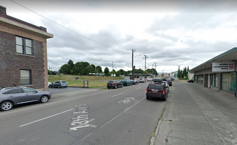
When the route turns onto 13th Avenue S, the trail will cross the street and run along the west side of the street, on the opposite side from Georgetown’s Old City Hall building. When it reaches S Albro Place, it crosses again to run alongside the King County International Airport.
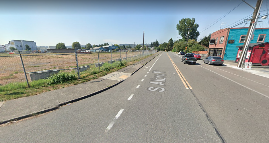
S Albro Place takes a turn to become Ellis Avenue S but the trail will stay on that side of the street all the way until S Myrtle Street.
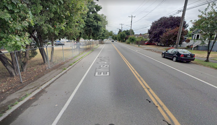
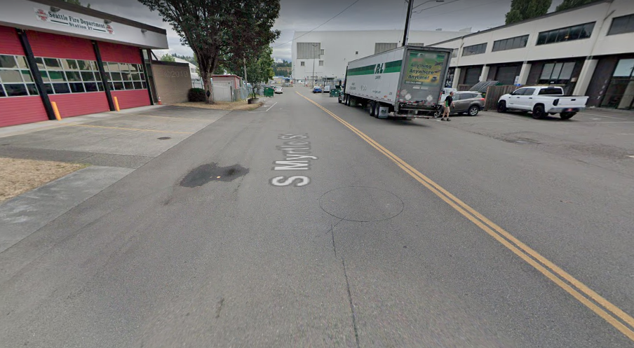
At that point, the trail heads away from the freight corridor on Ellis Avenue S and turns onto S Myrtle Street, a street that currently dead-ends at the airport. The trail will run in front of a Seattle fire station at this point. At the end of the block on Myrtle, trail users will cross the street and continue on the only segment of the trail that isn’t an existing street right-of-way.
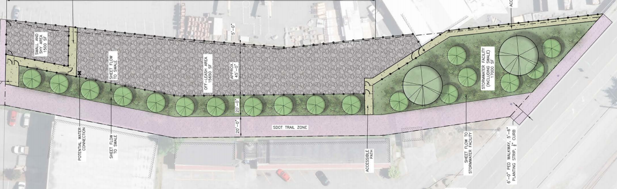
A former Seattle City Light property called the Georgetown Flume is being developed as an off-leash dog park that will provide the connection to East Marginal Way from the rest of Georgetown and a trail fully separated from any street. Amenities are being planned here like benches and bike racks (no restrooms, unfortunately) to make this part of the trail a place where you might want to stop. If you continue heading toward South Park, you’ll find yourself on the north side of East Marginal Way.
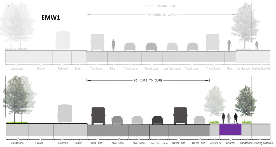
East Marginal Way will be the biggest improvement planned for people walking and biking along this route: the street is currently six lanes wide and traffic is heavy and fast. There are painted bike lanes in both directions on this street, but it’s absolutely a route for only the most assertive cyclists. At certain points, the bike lane swaps positions with a turn lane and people biking have to navigate that with traffic often going well over 30 mph.
The design will use the space currently utilized by those painted bike lanes and consolidate them into the trail along the north side of the street, on the other side of Marginal from the railroad tracks. Some of the travel lanes will get trimmed down from 12- to 11-feet. The sidewalk on this side of Marginal is minimal at best, partially missing at worst. This will be a truly dramatic improvement on a neglected corridor.
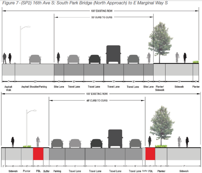
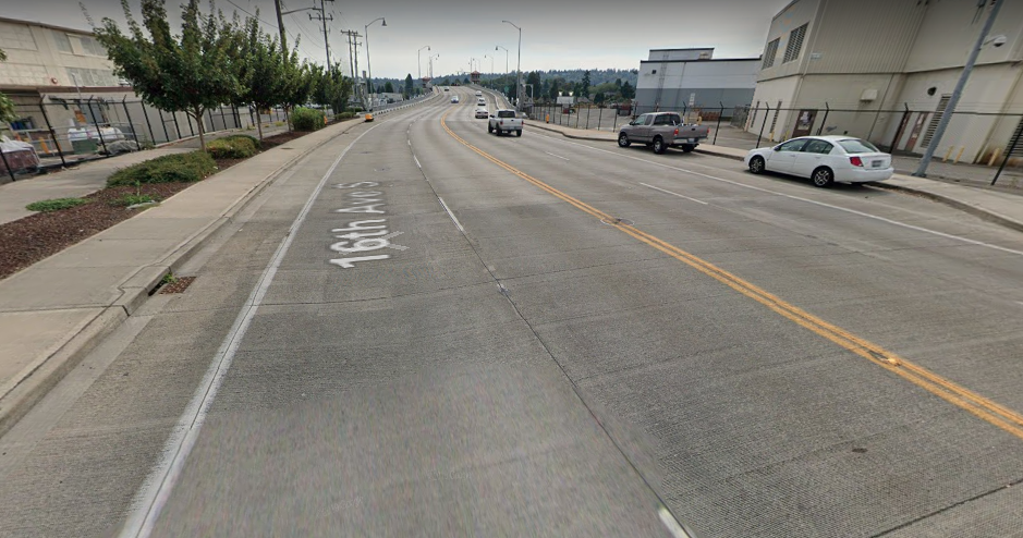
The trail will run along that side of East Marginal Way until it gets to 16th Avenue S. This is going to be one of the trickiest intersections on the entire route and we won’t have a good look at exactly how it’s going to work until the project reaches 60% design. The 16-foot shared-use trail will transition to five-foot protected bike lanes on either side of 16th Avenue S, with expanded sidewalks on either side of the street for people walking or rolling.
That design will run between East Marginal Way and the start of the South Park Bridge itself. No changes are planned on the actual bridge.
The South Park Bridge is under King County’s control. The bridge currently includes paint bike lanes in addition to the separated (but relatively narrow) sidewalks. “I could definitely see in the future, when the West Seattle Bridge does reopen, and when this trail is built, that could be an easy Phase 2, once we have more connections down there, to get the bike lanes protected on the bridge, but right now it’s not feasible,” said Hallie O’Brien, who is SDOT’s Project Manager on the trail, in response to a question from a member of the Seattle Design Commission about improvements here.
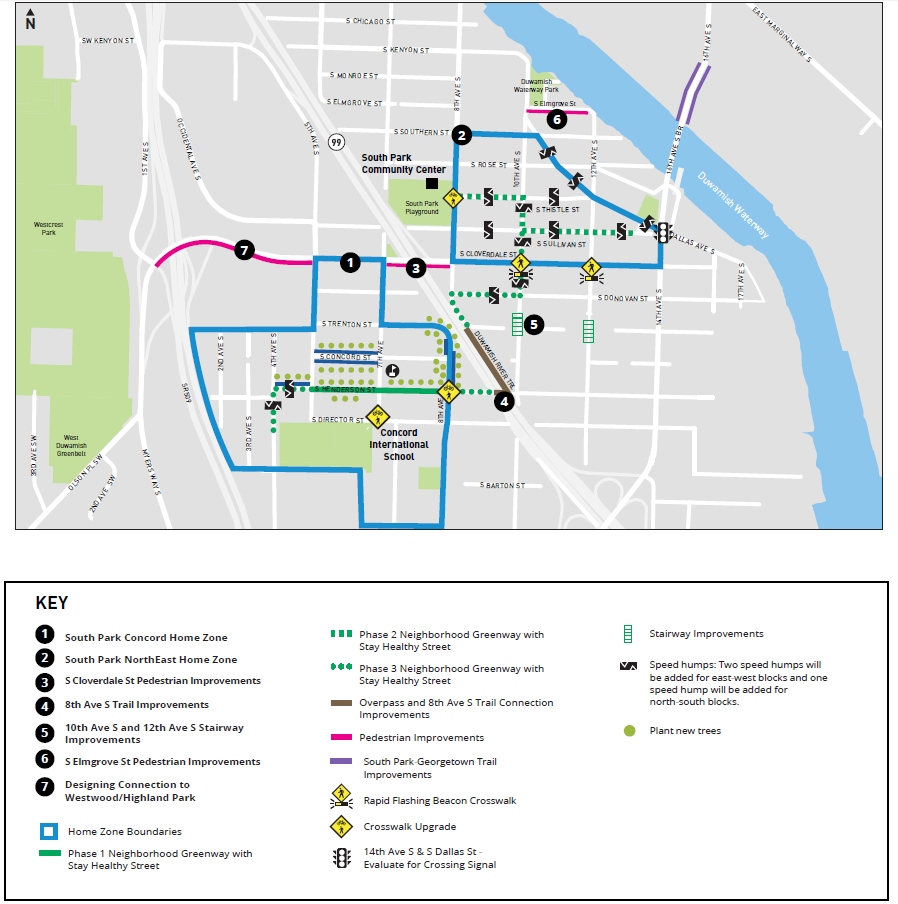
On the South Park side, no improvements are planned as part of this project. But traffic calming improvements coming to the neighborhood as part of the Reconnect West Seattle program are intended to provide the neighborhood with increased walking and biking connectivity. People biking across the bridge will likely turn onto Dallas Avenue S, which is getting speed cushions installed this spring. At 8th Avenue S, you can connect to the Duwamish River Trail but there is an entire slew of improvements planned in South Park to make it easier to travel between portions of the neighborhood, even if none of those improvements include separated bike facilities on an arterial.
On the Georgetown end, the bicycle master plan envisions a bike connection across the Albro Place overpass across I-5 in the future to connect with the relatively new bike lanes on Swift Avenue S. But taking space on an overpass used by freight traffic feels like a heavy lift. A direct connection to Downtown from Georgetown is becoming an urgent community priority and would do much more to connect the neighborhood to the rest of the city.
When will you be able to walk or roll on the Georgetown to South Park trail? Likely sometime in 2023. Construction is currently scheduled to start in late 2022 with an exact schedule not known until the project is closer to full design. Its opening will mark an important moment for Seattle’s bike network. You can keep up to date with the project at its webpage.
Georgetown-to-South Park Trail Will Be a Reality Thanks to Council Budget