Last week, the Seattle Department of Transportation (SDOT) announced that it had “refined” its earlier design of the stretch of the planned Burke-Gilman Trail running on Shilshole Avenue in Ballard known as the “Missing Link.” On the whole, it would be more accurate to say the trail design has been trimmed down, with several planned improvements — such as the relocation of railroad tracks, a wider buffer protecting the trail from motorized vehicles, and the installation of traffic signals — scrapped from the design.
On the bright side, the design changes should cut construction time in half to an estimated seven months, which could lead to the project being completed by 2024, or earlier, if it proceeds ahead as planned.
Even if whittled down to the essentials, the new trail design will improve safety conditions for pedestrians and cyclists along the current 1.4-mile Missing Link. The improvements will be particularly welcome where NW 45th Street and Shilshole Avenue NW currently devolve into a treacherous obstacle course of moving vehicles, railroad tracks, parked cars, unmarked intersections, driveways, loose gravel, and pockmarked pavement.
“Trail supporters, including many of my fellow Ballard residents, are excited about this plan. Creating safe, simple, and connected access for trail users of all ages and abilities to Ballard businesses is a dream come true. The plan, which improves safety for all travel modes, also aligns perfectly with the City’s Vision Zero goals, said Kevin Carrabine of Friends of the Burke-Gilman Trail in a press release from the City.

When that happens, a collective sigh of relief will likely echo from Seattle’s active transportation community, which has fought hard to maintain the preferred connection on Shilshole Avenue NW, despite ongoing lawsuits from local businesses arguing that a trail would interfere with industrial activities on the thoroughfare and create dangerous conditions at driveway crossings. In public outreach, the South Shilshole alternative was the overwhelming favorite, and the move signals SDOT remains committed to it.
Avoiding lawsuits
One advantage of the newest iteration of the trail’s design is that it should skirt future lawsuits by eliminating a need for a full State Environmental Policy Act (SEPA) environmental review. Even so, in a comment to The Seattle Times, Eugene Wasserman, president of the North Seattle Industrial Association and a longtime opponent of locating the trail on Shilshole Avenue NW, did not exclude the possibility of future lawsuits. While the new legal action may be wishful thinking on Wasserman’s part, the cloud cast by the twenty-year-long legal battle surrounding the trail’s completion makes it difficult for supporters to claim victory until the last of the green paint is dry.
“We have built more than 38 miles of bike facilities in the past four years, making many critical connections, but in many ways completing this glaring mile and a half gap in the Burke-Gilman Trail feels like the most symbolically important connection we have yet to build,” SDOT Director Sam Zimbabwe said.
Wasserman is also fighting against proposed bus lanes on Leary Avenue NW through Ballard and elsewhere on the Route 40 corridor, arguing it would slow freight traffic down too much. Ironically, Leary had been the main alternative to the Shilshole Missing Link alignment, favored by some in the business community.
While the prospects for a successful legal challenge to the scaled back plan may seem dim, the last legal challenge also appeared to be a longshot. Nonetheless, lawyers representing the “Ballard Coalition,” which included the North Seattle Industrial Association, were able to convince an Appeals Court judge that City’s Deputy Hearing Examiner Ryan Vancil was biased because he was promoted to Hearing Examiner following the decision. The March 2021 ruling invalidates Vancil’s 2018 decision and forced the City to start the case defending its environmental impact statement over again. Never mind the merits of the case (which are scant) or the fact Deputy Hearing Examiners are routinely promoted Hearing Examiners and we don’t invalidate all the earlier decisions even though most of their work touches policy enacted by the City Council, which also appoints Hearing Examiners.
Missing Link design details
While SDOT has stated that it will release more detailed plans in the coming months, a few major design updates have already been disclosed revealing important differences from the plan’s predecessor.
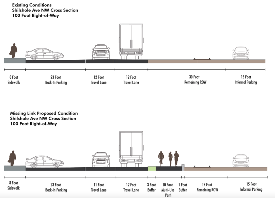
The first is the decision to maintain NW 45th Street as a one-way street for motor vehicles, which allows for the existing railroad tracks to be left in place, which significantly reduces the project’s cost and scope. A rendering from SDOT shows the existing road conditions compared to the planned changes.
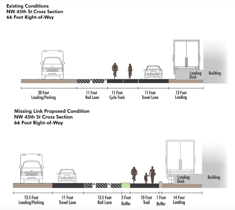
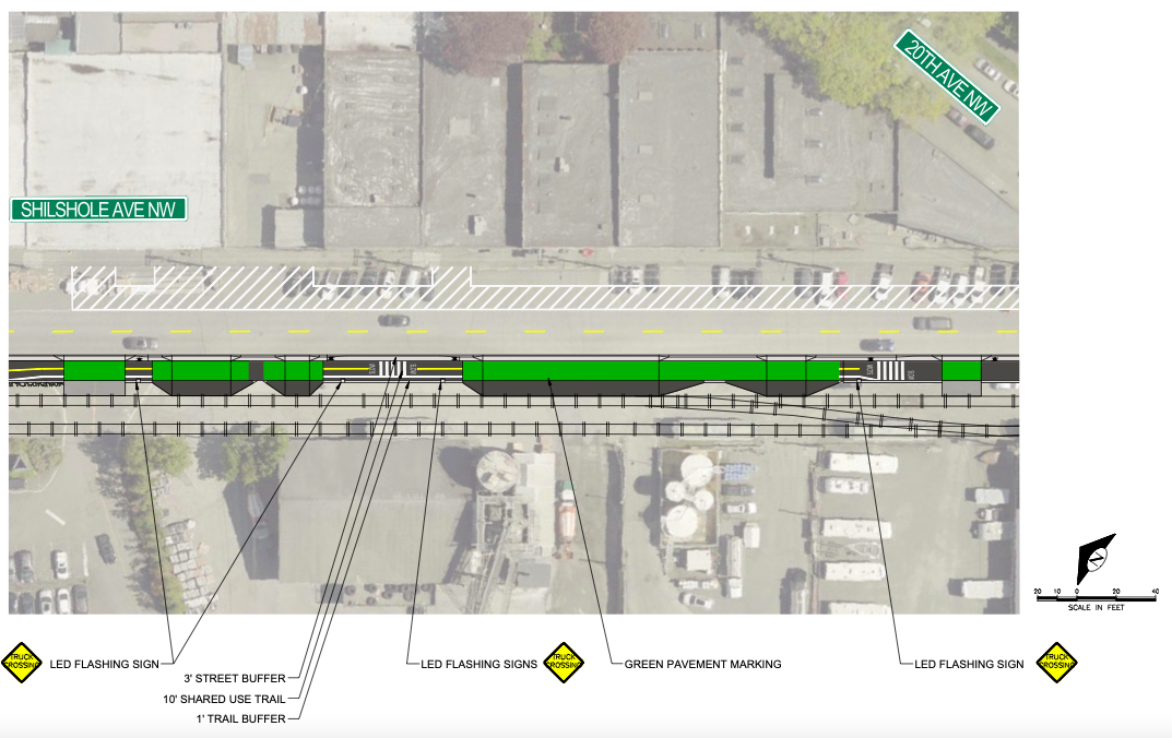
To accommodate the rail line, both the buffer and trail width have been reduced in width, a design change that remains consistent on Shilshole Avenue NW, where there will be an even more complex streetscape to navigate as a result of two different parking configurations.
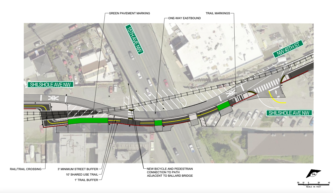
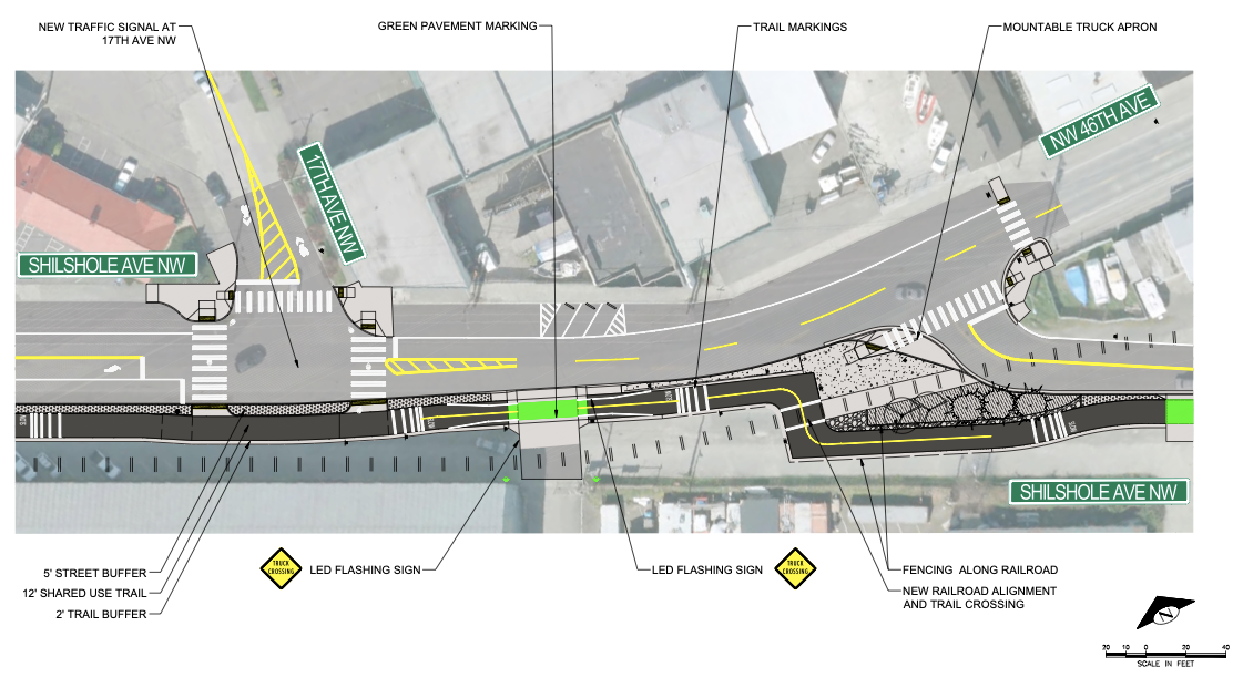
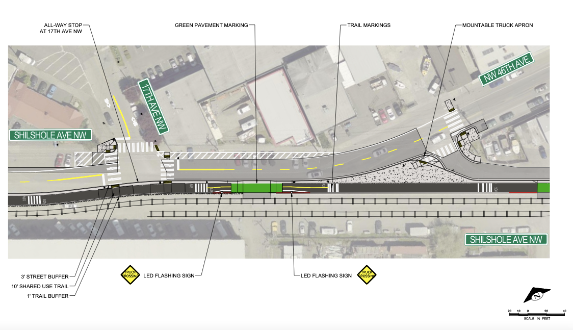
Trail users will need to be aware of a variety of tricky crossings and intersections. An aerial rendering from SDOT of the segment where the trail connects between NW 45th Street and Shilshole Avenue NW illustrates how the new plans intend to use green paint, buffers, and trail markers, to help keep trail users safe.
However, the changes have not come without sacrifice. The narrower trail width could lead to trail crowding during peak hours. Additionally, the loss of the three planned signalized crossings will make connections into the heart of Ballard more complicated.
A side by side comparison of the 2017 plan versus the new redesign casts the extent of the scaling back into relief. For example, a new traffic signal at 17th Avenue NW has been replaced with an all way stop, and curb bulbs and protective fencing have been removed. On the positive side, the decision to leave the rail tracks in their current configuration does, however, eliminate the need for a planned for trail crossing.
2017 Design Plan
2021 “Refined” Design Plan
SDOT’s new design plan for the Missing Link might not spark joy in the hearts of all trail users. It may even prove to be insufficient and need to be expanded on in future years. Yet, if it breaks a stalemate dating back all the way to the 1990s, the scaled back design might provide the city with a valuable gift. Plus, refurbishing and widening of the Burke-Gilman Trail and other key regional bike and pedestrian trails could make for a popular addition to a future transportation levy.
Beyond providing a safer means to traverse a messy stretch of roadway without a car, or even securing a 20-mile regional multi-use trail, resolving the question of the Missing Link will finally grant active transportation advocates a much needed opportunity to focus more attention on other areas of the city presenting dangers to pedestrians and cyclists. Let’s hope that building safe infrastructure on much needed corridors like Rainier Avenue South, Aurora Avenue North, and the connection between White Center and Georgetown can all be accomplished with a whole lot less time, money, and drama.
Readers interested into diving deeper into design plans can check out SDOT’s full new design.
Ballard High Line: Not a Solution for the Burke-Gilman Trail’s Missing Link