Critics of policies that increase urban density often point to negative impacts on tree canopy as reason to oppose zoning changes. Some opponents to Home in Tacoma, an affordable housing initiative, made the claim that introducing more housing types into single-family zoned areas would reduce the city’s tree canopy. Nevertheless, City Council passed Home in Tacoma toward the end of 2021, and over the next year we will see further development of the plan. Public comments have helped shape the overall vision of the initiative, and moving forward, lines will become more clearly defined and the true impact of the plan, down to its most finite details, will take center stage.
In a previous article, I explored the distribution of Mid-Scale housing zoned areas under the Home in Tacoma plan through the lens of Geographic Information Science (GIS). I performed an area-based analysis, breaking up the city into subregions and comparing them against one another. Disappointingly, I found uneven treatment between communities, particularly between privileged and underprivileged neighborhoods, with less Mid-Scale zoning planned for in historically White and affluent areas of the city.
Here, I’ll take a step further to explore the potential impacts of Home in Tacoma on Tacoma’s tree canopy. As a whole, data shows that concerns voiced about negative impacts of the Home in Tacoma zoning changes on tree canopy have been greatly exaggerated. At the same time, tree canopy is an integral component to the health and well-being of city residents, and Tacoma should create a vision of what we want tree canopy to look like under the Home in Tacoma plan.
Save the trees?
Any type of new building will affect the space around it. Utilities need to be placed, roads paved, signs put up, and all that jazz. These disruptions are nearly unavoidable as we shape the physical world to suit humanity’s needs. One way Mid-Scale developments could affect Tacoma’s space is by threatening the tree canopy. Trees may need to be destroyed or relocated, at high cost, to make way for new homes.
In a study conducted in 2018, the City found that Tacoma has a tree canopy coverage of about 20%, a disappointingly low number. For comparison, a 2016 study found that Seattle had about 28% tree canopy cover. Furthermore, according to KIRO7, Tacoma has the lowest tree canopy in the Puget Sound region. The reality is that most of Tacoma actually has less than 20% canopy cover, with open spaces like Point Defiance bringing the city average up.
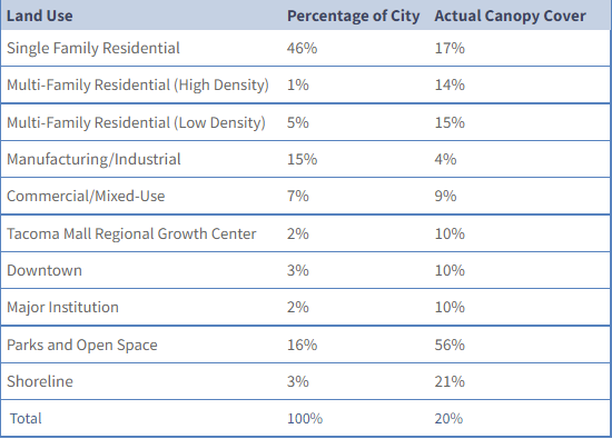
The study of Tacoma’s tree canopy is actually a component of the Opportunity/Equity index I mentioned in my previous analysis. As a reminder, the index uses 29 different variables to measure the health of and opportunities available to communities throughout the city. Tree canopy would fall under environmental health and currently, things aren’t looking too healthy. Even in single family residential zoned areas, tree canopy averages 17%. In multi-family residential areas, the percentage falls to 14%.
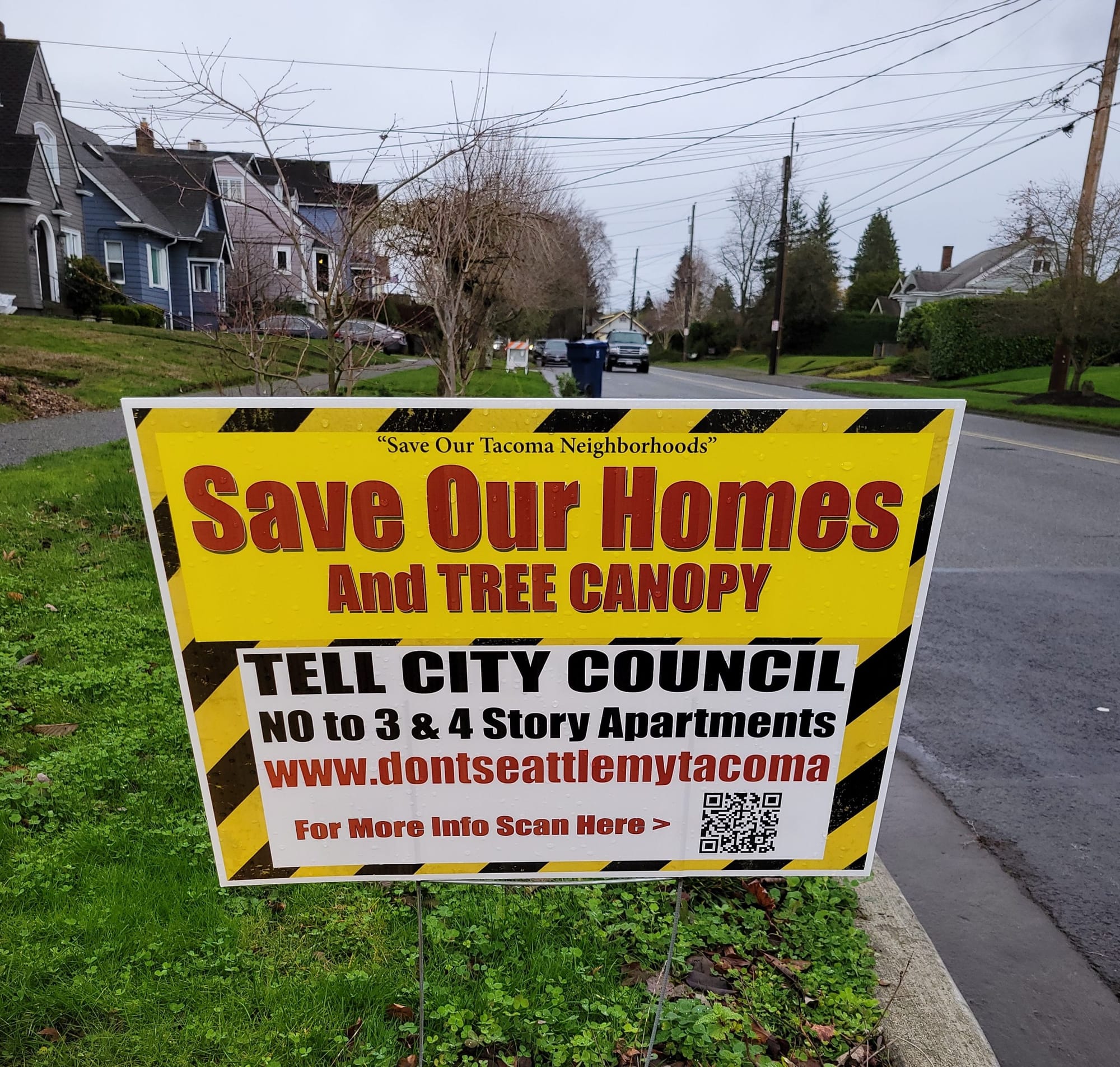
Nonprofit American Forests has assigned Tacoma a tree equity score of 77. The tree equity score takes into account factors similar to those accounted for in Tacoma’s Opportunity/Equity index, such as the number of people of color and people living in poverty in a given area. While Tacoma’s tree equity score comes in at about the national average, it also is much lower than Seattle’s score of 91. Additionally, areas assessed as lower opportunity, like neighborhoods in South Tacoma, have lower tree equity scores than the city average. Unfortunately, our tree canopy’s low ranking has not stopped opponents of Home in Tacoma from weaponizing our few woody friends against affordable housing.
Setting aside the problematic nature of prioritizing trees over human lives, the concern for trees is completely understandable. Not only do they provide the air we breathe, they help filter water as it penetrates the ground and washes out to the Puget Sound. Additionally, maintaining a strong urban forest has been shown to have significant benefits for residents, including increasing energy levels, speeding recovery and reducing power consumption. I’m sure none of us can argue against the benefits of enjoying a green view or saving some money on our power bill.
But how much of the City’s tree canopy would actually be affected by an increase in Mid-Scale housing? Are residents with these yard signs oracles of the future or deluded doomsayers trying to preserve their manicured yards? Evidence points to the latter.
Roots around town
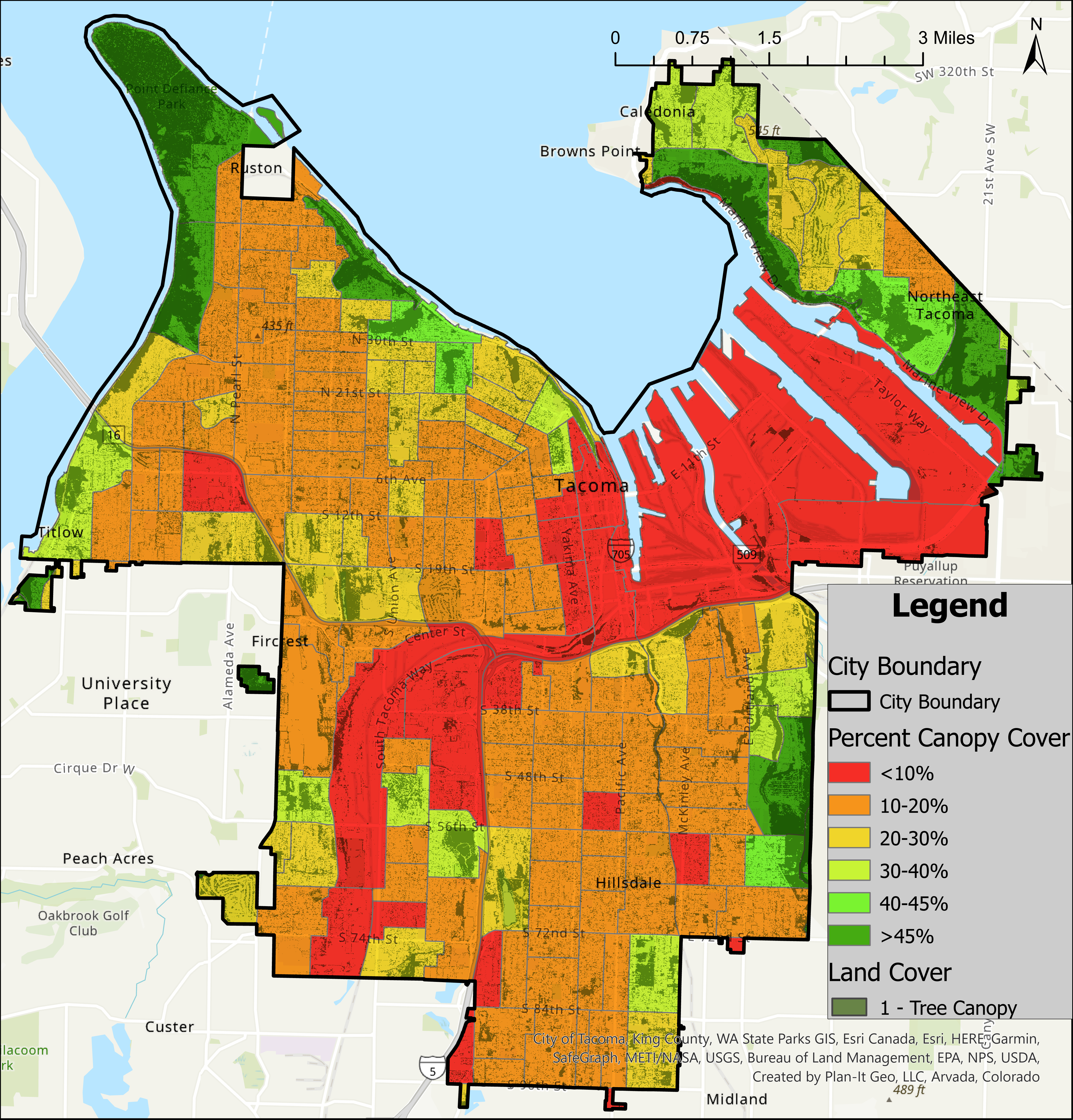
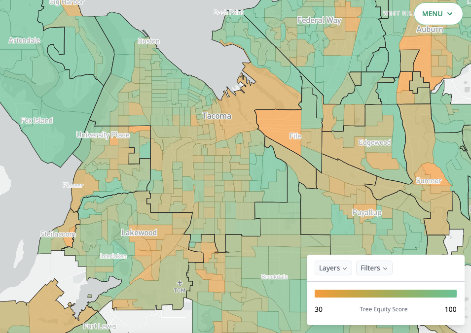
The above image shows the amount of canopy cover by census tract along with where it actually occurs. The colors indicate the percentage of cover while the dark shapes indicate where it is. As has been stated above, the majority of the city is red or orange, indicating less than 20% tree cover.
If you look at Point Defiance, it has a high degree of canopy cover that appears to be located closer to the water. Meanwhile, areas near the Port and Mall appear to have a lower degree of canopy cover, with patches of trees here and there. Throughout the city, you can see many different sized patches of trees. If you zoom in, you can even see where individual trees may be located. Though bear in mind that this is not a perfect map and locations may not be completely accurate. It is, however, a good map to get a sense of the distribution of trees in localities.
Broadly, using Interstate 5 and South Tacoma Way as a dividing line, it appears that North Tacoma has more trees. When you zoom out, the dark spots that indicate tree presence are larger than those to the south, indicating that the northern trees have wider coverage. Additionally, there seem to be more clusters of trees, especially near the coast. This makes sense because North End Neighborhoods are typically older and more preserved, and thus the trees would have had more time to grow.
But regardless of part of the city, the darker areas are spread out with more space than tree in most of the residential areas. While many of these neighborhoods are orange, indicating 10-20% tree cover, this tree cover is spread out across the entire census tract. This indicates that the residential tree canopies are discontinuous and not a connected system. Considering the table at the top of this article, the average canopy cover for residential areas is about 15.3%.
This shows that canopy density is actually lower closer to existing homes. Existing homes take up more space than trees. So if development were to occur on those individual parcels, a limited amount of tree canopy could be affected.
How many homes have fewer than three trees on their lot? Probably a lot, if not most. More than three? Not nearly as much. Dense canopy cover that spills into neighbors’ yards? They exist, but are very uncommon, especially if there’s a Homeowner’s Association involved (or angry neighbor!).
To gain a clearer idea of what tree canopy looks like in your area, open up Google Maps and turn on satellite view. Go to your neighborhood and pick a few houses, comparing the area of each roof against the area of trees you can tell are on the property. Does it seem like there’s more roof or tree? Check out some other neighborhoods as well.
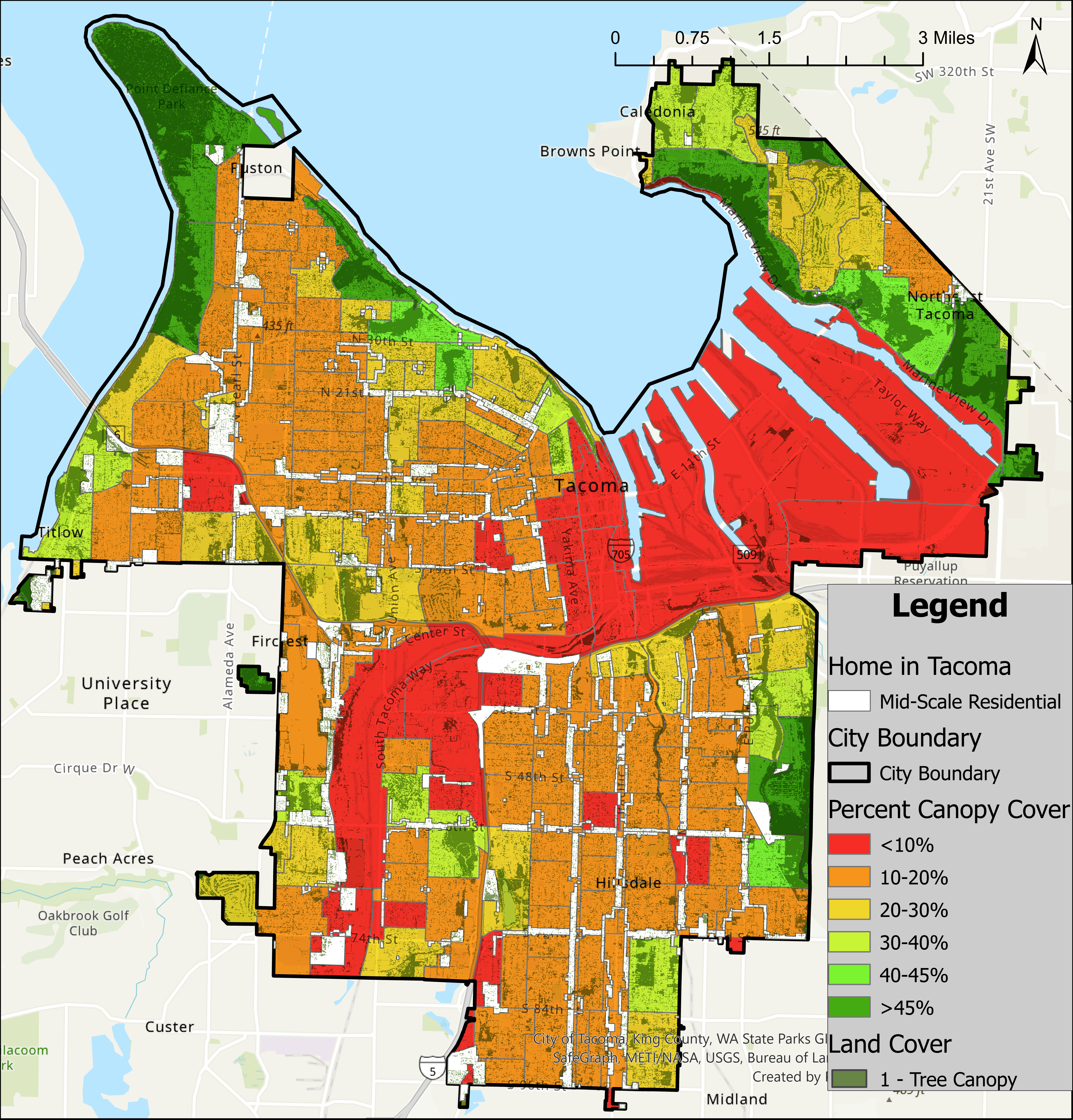
By adding Mid-scale zoned areas to the above map, we can see how much of the City’s tree canopy would be affected by looking at their overlap. And probably to the dismay of whoever put up that “Save Our Home and Our Tree Canopy” yard sign, most of the canopy is unaffected. Admittedly, there are portions of Mid-Scale areas that run into or are directly adjacent to clusters of trees, but these are few in number. All of the larger groups of trees are untouched, and as mentioned previously, some level of environmental disturbance is simply unavoidable.
Much of the Mid-Scale rezone occurs along high transit corridors, where there are often fewer trees anyway, especially in South Tacoma. When you remember that North End neighborhoods are barely penetrated by Mid-Scale, as I found in my previous GIS analysis, the relatively small impact on the tree canopy becomes clear.
Now this is not to say Tacoma’s tree canopy won’t be affected. It will, but the impact of zoning changes in the Home in Tacoma plan on the canopy has been exaggerated by critics. Recall that a majority of the current single family residences will be rezoned to Low-Scale housing. Generally, this means that the building will be untouched, modified or replaced with a similarly sized building. In these cases, the building should not radically change in size. Landowners and developers need only put in minimal effort to work around existing trees.
As has been iterated before, Home in Tacoma is a policy change to increase flexibility and encourage housing development. In no way is the city forcing development to happen aside from giving out incentives. It is on property owners and developers to capitalize on the new flexibility.
Growing into the Future
Wanting to preserve what little urban forest remains in Tacoma is totally understandable. The benefits of urban trees are indisputable. However, preservation of existing tree canopy shouldn’t take precedence over providing housing for residents who cannot afford it. To fight to preserve the existing tree canopy really only benefits those who have stable housing. And as we are all aware, it is becoming increasingly difficult for the typical Tacoma resident – or American – to obtain that.
Instead the focus should be on what we want the tree canopy to look like with the implementation of Home in Tacoma. Perhaps there needs to be a policy of planting new trees on a property for every tree cut down? Or maybe standards around minimum tree coverage per neighborhood block should be instituted. Looking ahead, rather than focusing on maintaining the status quo, is a guiding principle of Home in Tacoma.
We can’t forget that the city is as alive as any of us and will change over time.
The City is well aware of the tree canopy issue and has been working since 2017 to plan and build up Tacoma’s tree canopy through the Urban Forest Management Plan. Essentially, the plan aims to increase canopy coverage to about 30% by 2030 to align with other Puget Sound cities through research, training and policy implementation. Two of the three phases, Research and Action Planning, have already been completed and passed in December of 2019.
Unfortunately, there has been little word about the plan since then. The project’s main website cites the COVID-19 Pandemic disrupting funding and shifting focus to other policies as drivers of inaction. It goes on to say work on tree assessment and protection alongside updates to policy language has been underway in 2021. But it’s unclear when that work will be completed or when the next announcement will be.
With work around the specifics of Home in Tacoma being initiated soon, it is important for the City to advance its Urban Forest Management plan. New development provides the opportunity to add more trees, or other greenery like green roofs, in neighborhoods where they are currently lacking. With the right policies in place, both urban density and tree canopy can grow hand-in-hand in Tacoma.
As always, the City continues to take public comment for the Home in Tacoma initiative at: planning@cityoftacoma.org. Visit the project planning webpage to find more information and sign up for the project newsletter. To explore the Urban Forest Management Plan further, visit the project website. Public comments can be sent to trees@cityoftacoma.org.
Thank you to the Elliot Barnett and the City of Tacoma Planning Services Department for providing data and comments that made this analysis possible.