On Thursday, Sound Transit shared future Link system map and station wayfinding sign concepts with members of the Sounding Board. The system maps and station wayfinding signs are a significant departure from the past with the introduction of station numbering. This strongly suggests that the agency is considering adding specific identification numbers to stations. Right now, stations are identified by a name and corresponding pictogram.
Rapid transit rail systems in cities like Taipei, Seoul, Singapore, Tokyo, and Bangkok use various station numbering systems (sometimes mixed with letters) in signage and map media rather than pictograms. This is because numbering is simpler, more meaningful, and universally understood regardless of language spoken by riders whereas pictograms quickly become burdensome to remember and identify the more that exist in a system — you won’t find people referring to Westlake and Roosevelt Stations as the crown and moose stations. In North America, only two major rapid transit rail systems use station numbering with those being in the Atlanta and Washington, D.C. areas. The numbering systems in those cities usually make it fairly easy to understand where a rider is within the rapid transit system and count how many stations that one must travel between points. Riders can also easily know if they’re headed in the wrong direction.
Legally, Sound Transit is required to use some form of alternative station identification. RCW 81.112.190 explicitly states that the agency “shall incorporate in plans for stations along any light-rail facility signing that is easily understood by the traveling public, including, but not limited to, persons with disabilities, non-English-speaking persons, and visitors from other nations” and that “signage must also use distinguishing symbols or pictograms developed by the authority as a means to identify stations and may identify points of interest along the corridor for persons who use languages that are not Roman-alphabet based.” That latter language suggests that a numbering system could meet the law without pictograms.
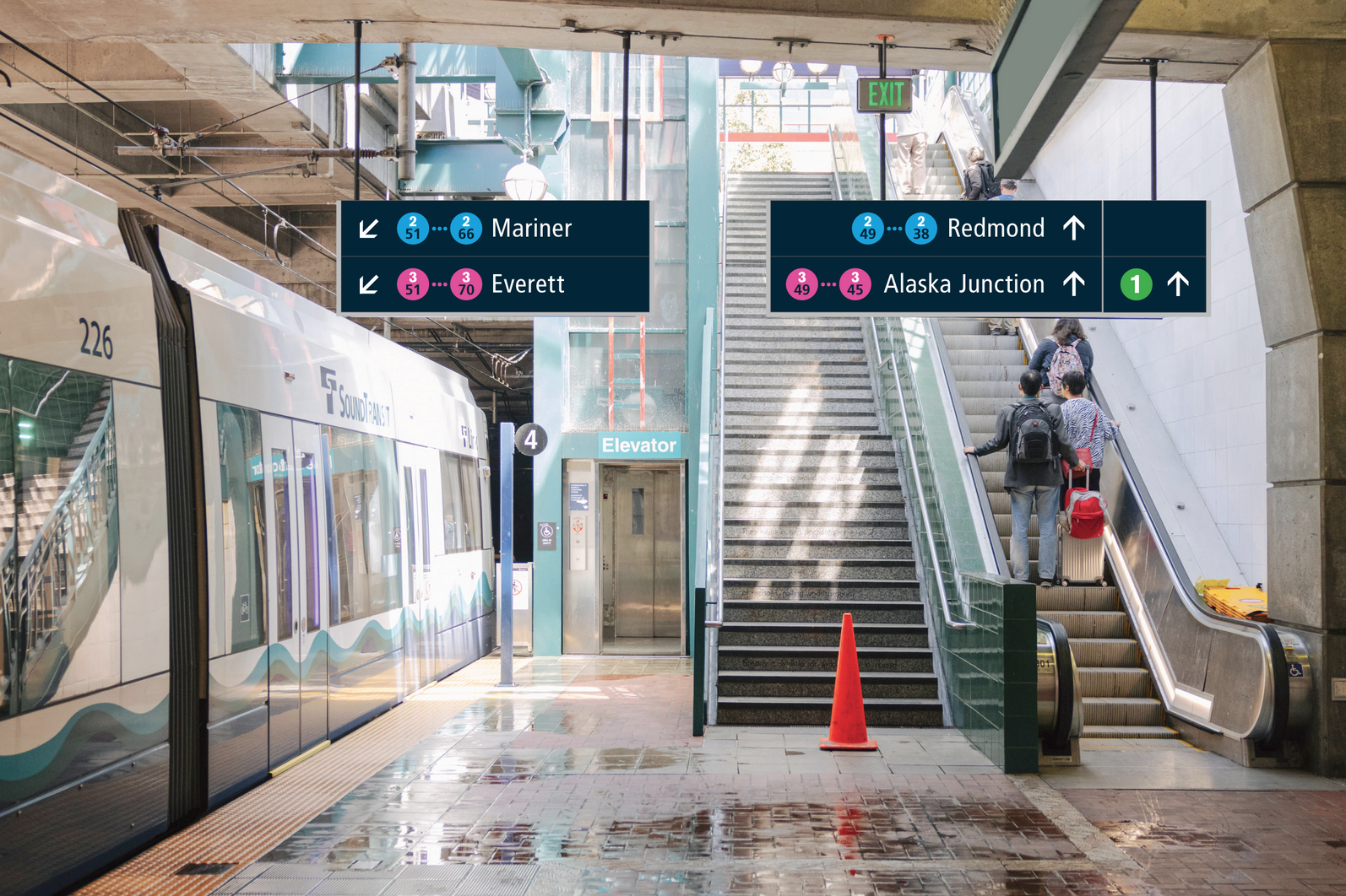
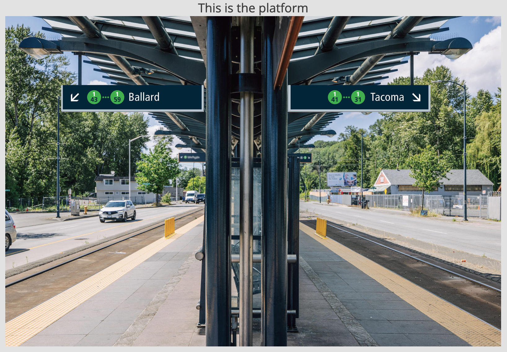
Renderings of the station wayfinding sign concepts show two different platform types. One is a future interchange station (International District/Chinatown Station) and the other is a station that won’t offer interchange service (Rainier Beach Station) as the Link system expands. This is important because interchange stations could have more complex wayfinding signage.
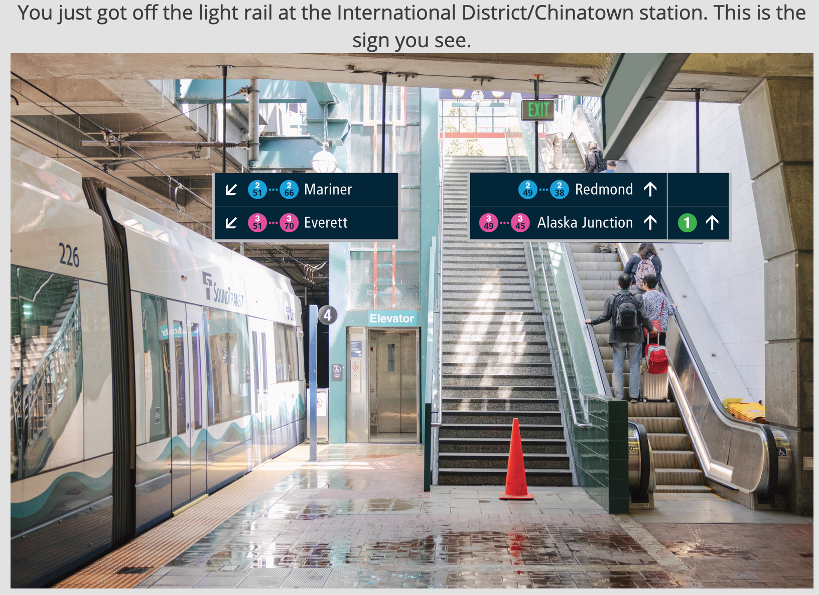
In the International District/Chinatown Station example, the northbound platform is shown with two sets of signage: signage pointing riders to the 2 and 3 Lines serving stations north of the station reachable directly from the platform and signage pointing riders toward the stairs to reach platforms where riders could catch platforms serving the 1 Line as well as the 2 and 3 Lines with stations south and east of the station. With the 2 and 3 Lines shown on the signs, terminal stations of the lines are indicated alongside circle shields with the line number and color plus station numbers included in the shields. In the direction of Mariner Station on the 2 Line, stations numbered “51” through “66” would be served whereas station numbered “51” through “70” would be served on the 3 Line in the direction of Everett. These numbers correspond to conceptual Link system maps.
Similarly with the Rainier Beach Station example, the platform signage would show the direction trains are headed with the appropriate terminal station (in this case Ballard and Tacoma) on the 1 Line. In the Ballard direction, stations numbered “43” through “59” would be served whereas stations numbered “41” through “31” would be served in the Tacoma direction.
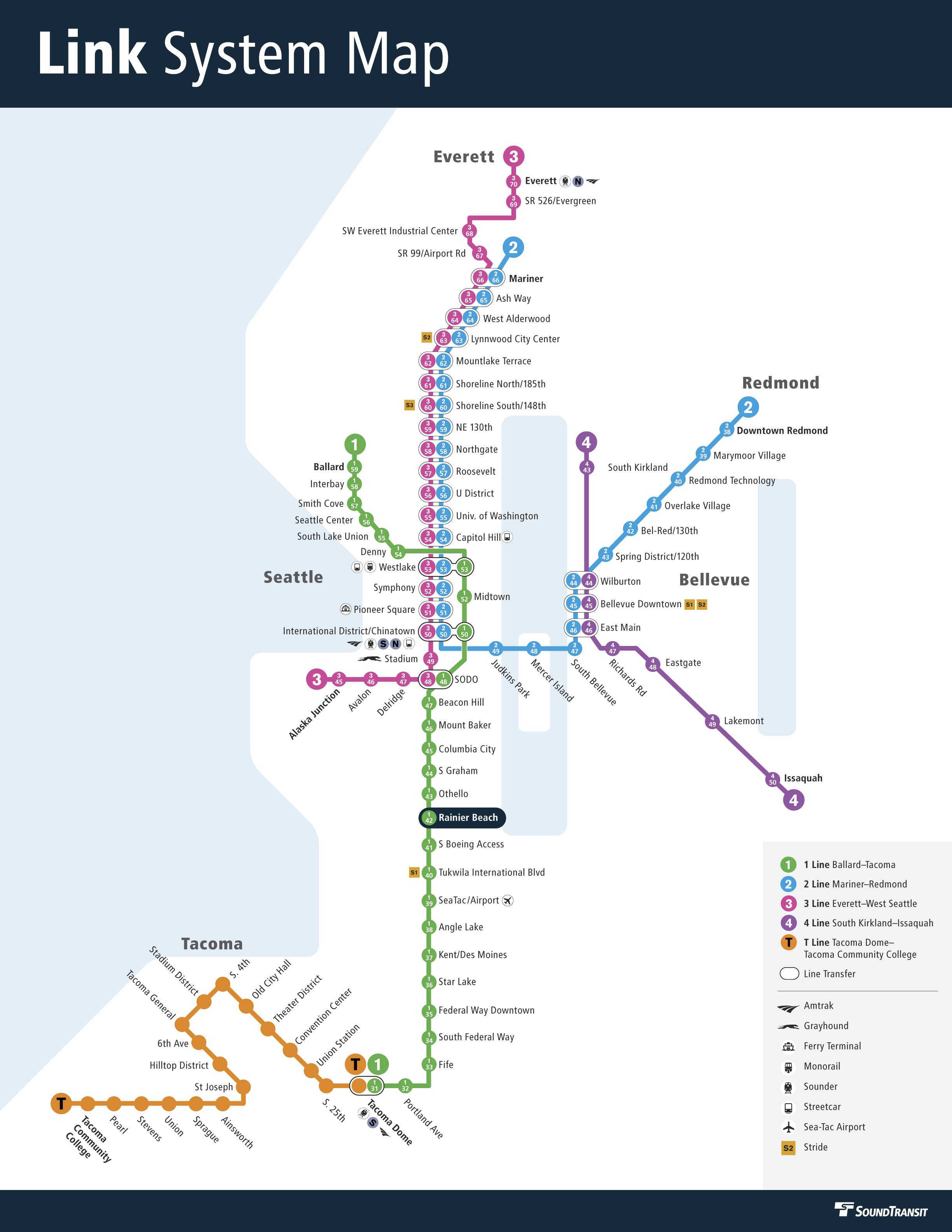
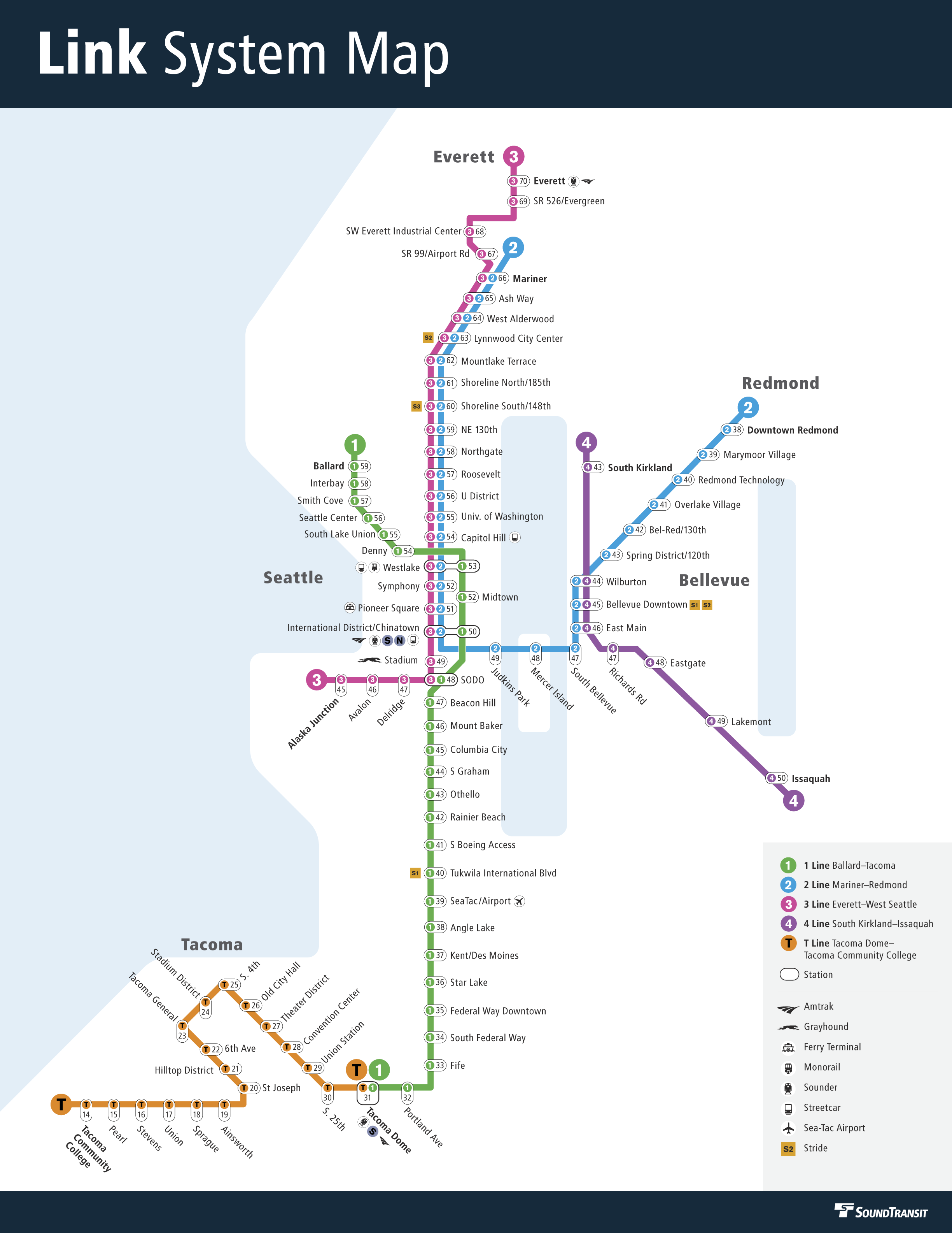
As for the Link system map concepts, Sound Transit is testing three versions with station numbers. All three are close permutations. Lines are shown with typical shields, line colors, and station names in a diagrammatic format, but just one option would number the Tacoma T Line.
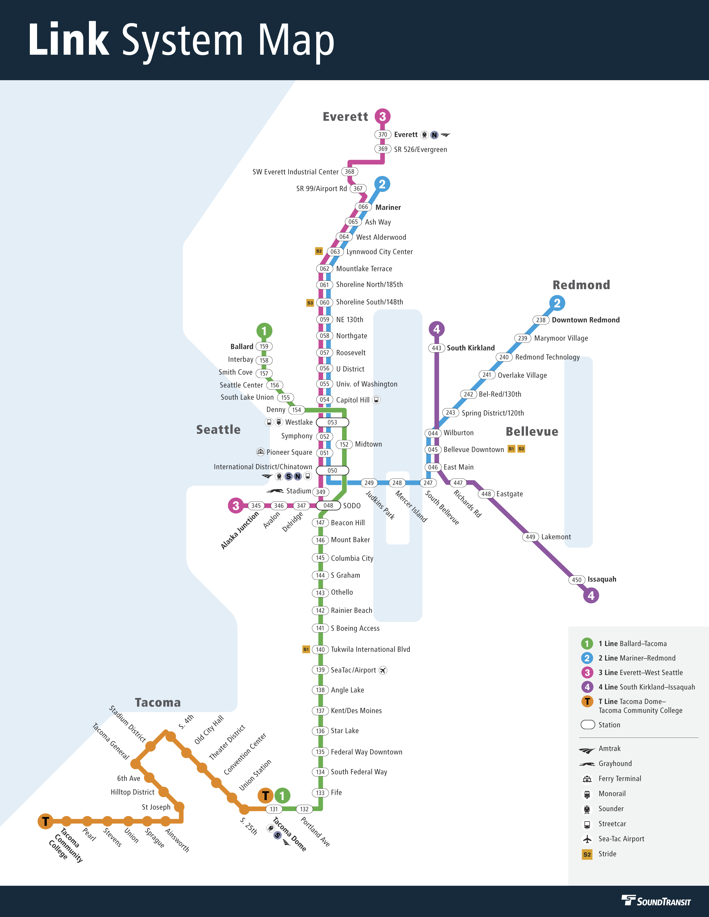
Option 1 would start station numbering at International District/Chinatown Station with “050” since it will be the most important interchange hub in the system. Stations that follow after this station are numbered relative to this with “higher” or “lower” numbers. All interchange stations would use the “0XX” format while stations that don’t offer an interchange would use the corresponding line number as the first number (e.g., “1XX” for the 1 Line and “4XX” for the 4 Line). Clever riders will be able to math their way between stations if they intimately know the logic to the numbering system. Traveling from Mariner Station (066) to Issaquah Station (450), a rider might know to run arithmetic as follows: (0(66) – 0(50)) + (0(50) – 0(46)) + (4(50) – 0(46)) = 24 stations/stops.
Option 2A is somewhat similar, except that lines have color circles that match the line colors and only have a two-digit station number. At the top of the circles, the line number is shown. Arguably, this could be interpreted as a three-digit number. At interchange stations, each line has a circle with the applicable station number. As an example, Westlake Station would have three line circles: “1-53” for the 1 Line, “2-53” for the 2 Line, and “3-53” for the 3 Line. Numbering of the system also starts at International District/Chinatown Station like Option 1.
Lastly, Option 2B adapts Option 2A’s approach by using the line shield for each station on the respective line and drawing a larger bulb around these that includes a station number. Functionally, it works the same as Option 2A, but uses less real estate, especially for interchange stations. At Westlake Station, each line is denoted with the line shield (i.e., “1,” “2,” and “3”) and the station number is added to the far right of these (“53”). Riders would intuit this as “153,” “253,” and “353” for the station. This option would also number the T Line stations “14” through “31” or “T14” through “T31” when including the line identifier.
Perhaps less important, the system maps also show connection opportunities with other key services, including: Stride bus rapid transit, ferries, trams, airport and monorail, commuter rail, and intercity bus and passenger rail.
One member of the Sounding Board, who manages the Safe Lake City Way account on Twitter, shared with The Urbanist that members were given an interactive survey related to the maps. Members were asked to “take a few ‘virtual trips’ using one of the proposed map/signage layouts” and then evaluate all three map concepts. The feedback from that will undoubtedly be important to Sound Transit’s decision-making and refinements around any particular approach.
Already, the concepts are eliciting good public commentary. Oran Viriyincy, a professional transit cartographer, suggested some changes on Twitter today, such as better emphasizing line identity on signage, dropping the station number ranges on destination signage, and grouping line and station numbers for shared segments. Viriyincy even whipped up an alternative rendering of his suggested changes, which added a station name and number sign mockup.