The Seattle Department of Transportation (SDOT) spends millions of dollars per year maintaining and replacing equipment on its traffic signal system, which consists of signals at over 1,100 intersections. Frequently, the department embarks on larger signal upgrade projects, perhaps most famously when it revamped signals along Mercer Street between Uptown and I-5 through South Lake Union with “adaptive signal” technology.
In past years, the department has moved forward these signal upgrade projects, known as Intelligent Transportation System (ITS) projects, in Georgetown, the U District, and north Downtown on Denny Way as part of Climate Pledge Arena’s transportation mitigation measures, in addition to the one on Mercer Street. SDOT has a yearly goal of adding 10 miles per year to the ITS system, a goal it has been able to meet in recent years.
The stated aim of these projects is to move people and goods more efficiently through the existing signal network, but that doesn’t mean there aren’t tradeoffs when SDOT chooses to invest in increasing vehicle throughput through a corridor in an urban environment.
This year, SDOT sought a federal grant for its next planned ITS project, which would upgrade signals on N 80th and N 85th Streets in North Seattle, between I-5 and Crown Hill. “These ITS improvements relieve pressure on the overall system by operating key corridors at maximum capacity. Traffic-management tools, such as signal synchronization, signal optimization, and signal priority for transit, all serve to maximize the throughput of people and goods on a specific roadway. However, the benefits are not limited to specific corridors; they are network-wide,” SDOT’s grant application, submitted through the Puget Sound Regional Council, stated.
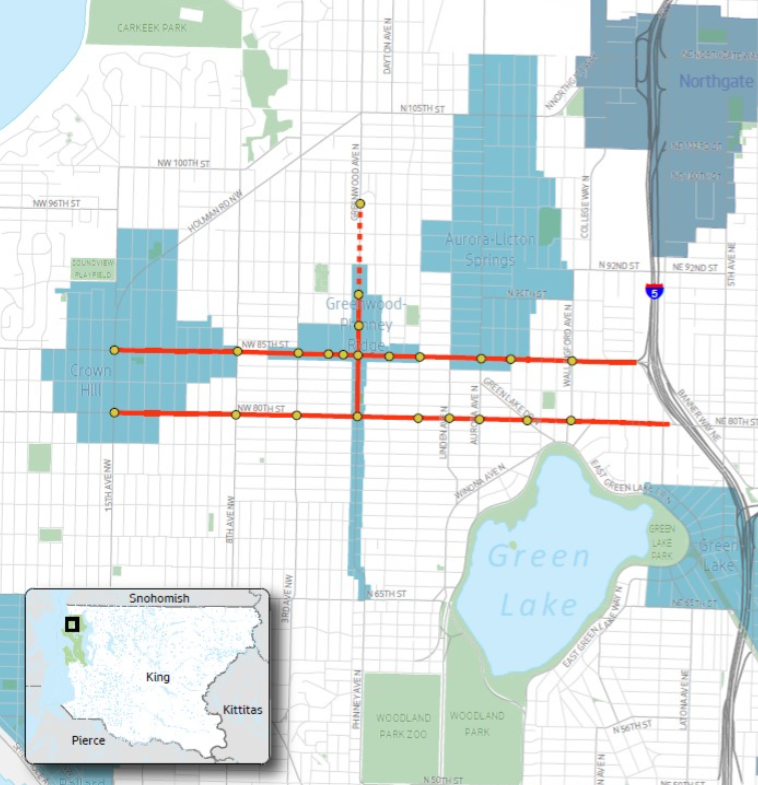
The project would spend $4.8 million to improve travel times by one minute overall, three minutes during times of peak evening travel, although a full traffic analysis hasn’t yet been completed. Though the grant application touts the benefits of keeping transit and freight moving, no dedicated space for either transit vehicles or heavy freight is proposed as part of the project. The application notes the expected growth in the Crown Hill, Greenwood-Phinney Ridge, and Aurora-Licton Springs urban villages — by 7,200 housing units by 2035, or close to 40%.
So is it actually in the best interest of the current and future residents of those neighborhoods (and everywhere in between) for the city to prioritize the movement of vehicles on 80th and 85th?

I asked SDOT whether the project was consistent with other department programs, like Vision Zero, which is aimed at meeting a City pledge to eliminate traffic deaths and serious injuries by 2030, but is far off course as pedestrian deaths continue to climb. SDOT speeds on the corridors average close to 20 miles per hour: Would increasing those speeds align with preventing serious injuries from crashes?
“We have received frequent complaints about the signal operations and delays along these corridors and it is primarily due to the lack of ITS communications along the corridor,” SDOT spokesperson Mariam Ali responded via email. “Looking at travel time data along the corridor, there are opportunities to reduce delays and improve travel speeds during the peak periods, but that does not necessarily mean that travel times during non-peak period will automatically increase. Reducing delays and improving travel time during the peak period would likely reduce stops and idling and would provide some benefit to the environment, which improving climate change is a goal of the City.”
But reducing idling on an individual level doesn’t help the city achieve its climate goals if the free-flowing traffic on 80th and 85th prompts more drivers to use the street. I also asked SDOT how the project could improve travel times for modes the city wants to encourage, like pedestrian trips. Ali told me that the current assumption is that the project will attempt to remove “split phases” at intersections like 85th and 3rd Avenue NW and 8th Avenue NW.
In a split phase, vehicles on one leg of an intersection can make turns and go straight at the same time, forcing pedestrians to wait no matter what direction they’re heading. That would also reduce delays for vehicles as well. Leading Pedestrian Intervals (LPIs), where a pedestrian gets an extra few seconds of walk time before a green light, would also be added, but those are being widely deployed around the city as it is. There don’t seem to be any direct benefits aimed at people walking and biking with this project that would prioritize them over vehicle traffic.
The City of Seattle has (mostly) recognized that it isn’t able to widen city streets to increase capacity for vehicles. But trying to do the same by way of enhanced signal technology also pushed against adopted City goals, namely the need to shift travel away from single-occupancy vehicle trips. Improving travel times by car between growth centers in North Seattle, without setting aside dedicated space for transit, or freight, seems backwards in a city seeking to decreased vehicle miles traveled (VMT) by 20% compared to 2008 levels by 2030.
Late last month, the Puget Sound Regional Council approved an initial list of projects that were approved for grants: the 80th/85th ITS project wasn’t awarded funding, but it was placed on the contingency list in the event other projects become ineligible. Though the project isn’t moving forward immediately, the proposal likely won’t go away any time soon. Ideally, SDOT would turn its attention to how to move transit, as well as people walking and biking, between urban centers around the city and leave prioritizing all vehicles to the traffic engineers of the last century.