Public input requested on the slim pickings for regional light rail station sites.
Sound Transit has an open scoping period for the Everett Link Extension, the initial phase in developing a federally-required Environmental Impact Statement (EIS). The project is slated to be completed in two phases and extend light rail from Lynnwood to Everett Station by 2041, adding 16-miles to Link. The scoping materials show the representative alignment and station locations presented to voters in 2016 as well as a number of alternatives under consideration in each segment. These are very similar to the ones already reviewed in the Level 1 and Level 2 alternatives development phases, but the alternatives have been refined and narrowed down.
Absent from the materials are potentially higher-performing and highly-requested alternatives along SR 99 and I-5 in South Everett. Those alternatives were prematurely cut following efforts by Snohomish County Executive Dave Somers and Everett Mayor Cassie Franklin to quash them before critical analysis. This scoping and EIS processes, however, could bring those alternatives back to the table for consideration. Just as popular comment willed them into the alternatives development process last year, we will discuss how to make that happen again in a second installment on Monday.
For now, let’s dig into the station and station area alignment alternatives on the table.
Overview maps of the Everett Link Extension:
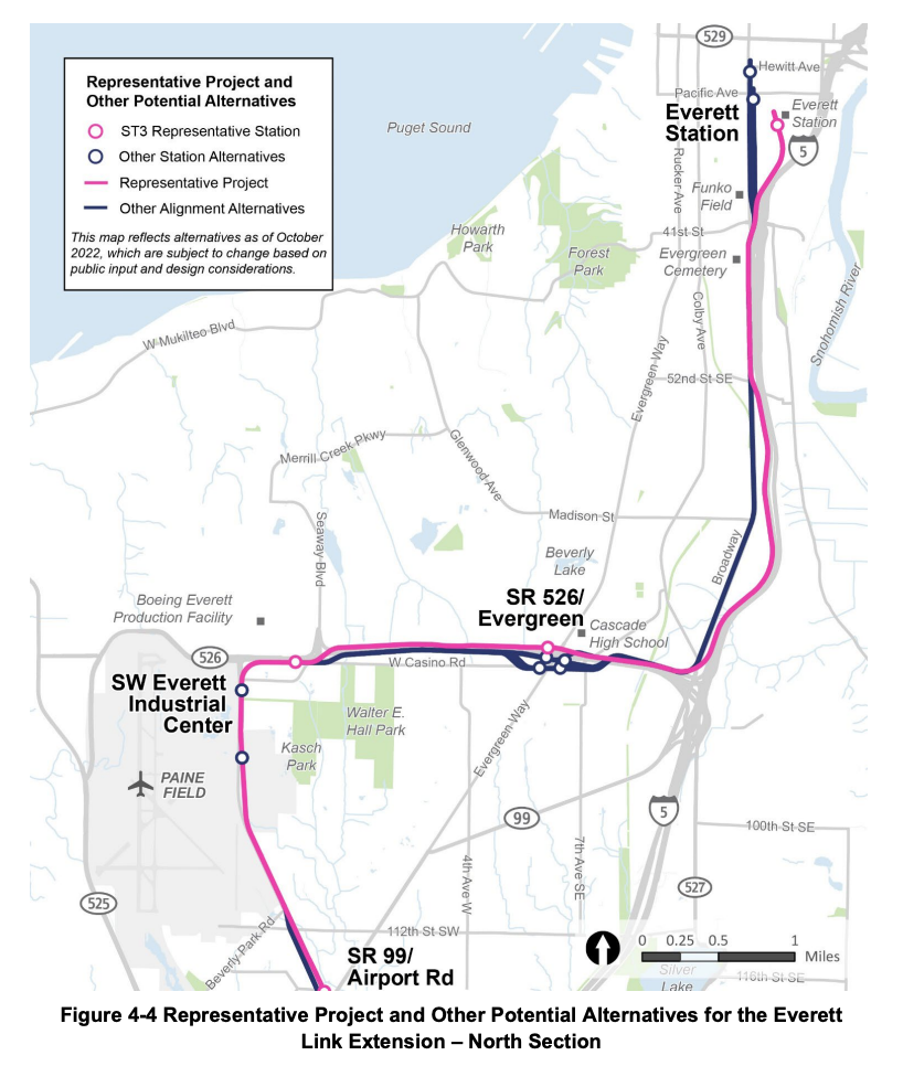
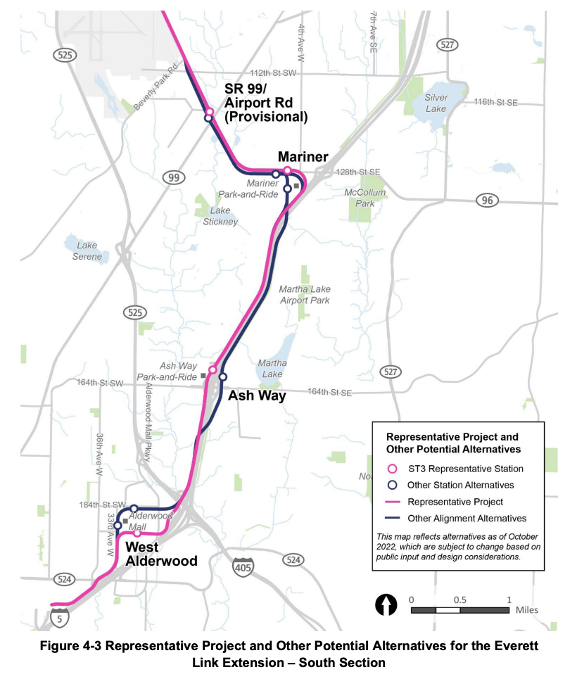
Everett Link Station Location Alternatives.At West Alderwood, potential routing and station locations have been trimmed down to three alternatives.Alternative ALD-F to the north of the mall next to REI and Nordstrom’s.Alternative ALD-D to the west of the mall outside of J.C. Penney.Alternative ALD-B to the south of the mall between the food court and the movie theater.
All of the stations are located on parking lots of the evolving shopping complex. The best station location of the bunch is to the west of the mall because it would provide the widest walkshed. That may require realigning bus service in the future to serve it, but the ALD-D station would see much higher performance because of the local land use implications facilitating more walk-to-station ridership. Alternatives closer to the freeways will not be nearly as amenable to such ridership.
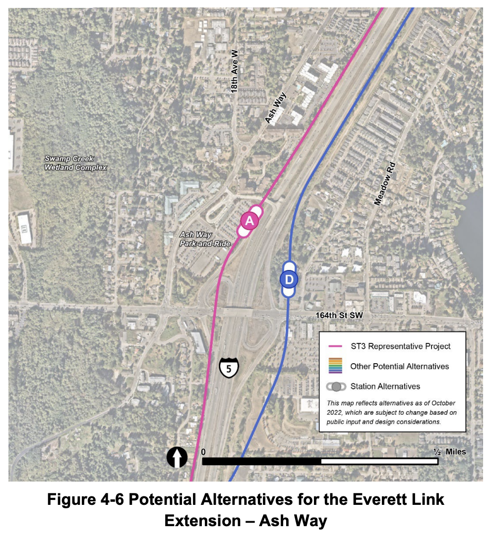
At Ash Way, just two options made it into the scoping process.
- Alternative ASH-A would place an elevated station right next to the existing bus loop at the park-and-ride facility.
- Alternative ASH-D would locate an at-grade station on the east side of I-5 just north of 164th Street SW.
While there are many apartments north of the existing park-and-ride, the area is relatively hostile to pedestrians — in part because of the parking part of the park-and-ride — and the residential developments are very heavily parked. A major habitat corridor and creek also runs north-south two blocks to the west, which limits potential walksheds and bikesheds — though strategic trail crossings could improve that. Station area planning could make this area more useful for walk-to-station ridership, but there may be higher potential to the east of I-5.
More transit-friendly apartments have been popping up east of I-5 and residential development capacity in area may be substantially higher simply because the location is surrounded by fewer parcels of land, most of which are fully built out or in single-family home ownership. ASH-D also would require many fewer residential displacements and would directly tie into the Interurban Trail. Both areas have similar high-density zoning types, but expansion of such zoning further east of I-5 is far more promising.
Ultimately, an ASH-D station may optimize ridership, especially if the parking facilities are located at the existing park-and-ride site and a pedestrian crossing is threaded to the new station. On the cost front, the alternatives each have their tradeoffs with more property acquisition and elevation required west of I-5 and several under/overpasses required on the east side of I-5. It is concerning though that Sound Transit’s early station concept east of I-5 would waste a lot of space in surface bus bays that could easily be covered by residential and commercial structures instead.
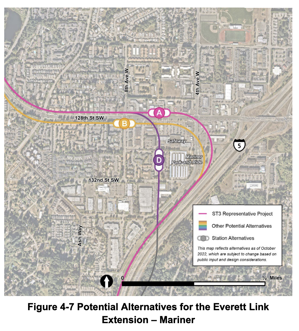
At Mariner, three alternatives have survived, all to the west of the existing park-and-ride.
- Alternative MAR-A would put a station on the north side of 128th Street SW between 4th Avenue W and 8th Avenue W.
- Alternative MAR-B would put a station on the south side of 128th Street SW right at 8th Avenue W.
- Alternative MAR-D would locate a station just south of the existing Safeway.
While MAR-D would be centrally located, its alignment would require substantial property acquisitions, including many residential displacements. MAR-A and MAR-B don’t require that though, but among them MAR-B would be much higher performing for future development and walk-to-station ridership. MAR-B is unquestionably the best of the lot.
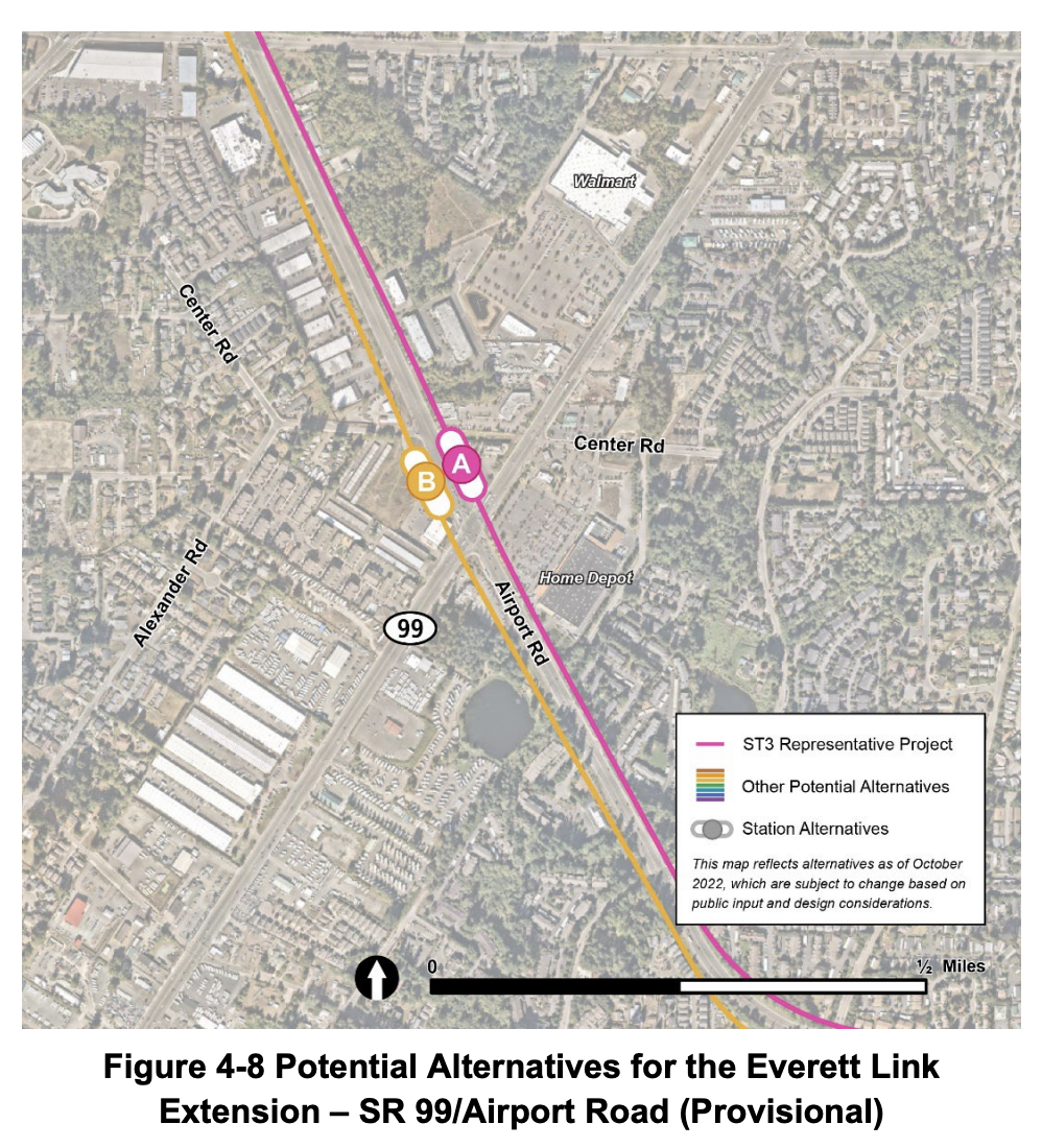
At SR 99/Airport Road, the options have been narrowed to two alternatives west of SR 99 and the provisional station is still unfunded.
- Alternative AIR-A would locate a station on the north side of Airport Road.
- Alternative AIR-B would locate a station on the south side of Airport Road.
Which is better is really a flip of a coin because the area is dominated by the car as far as the eye can see. Whatever option is chosen, policymakers should vastly trim down SR 99 and Airport Road for the safety and well-being of all. Barring that, constructing pedestrian bridges crossing all sides of the monstrous SR 99/Airport Road intersection would be a must. Besides the stations, this segment does show that elevated guideway would go over private property, not in the public right-of-way. Sound Transit must reconsider this obviously absurd assumption and put guideway within the existing right-of-way. Airport Road could benefit heavily from car removal and it would nudge some corridor users to transit. It’s time to start treating transit as a supplantive modal transportation investment, not just an additive transportation investment.
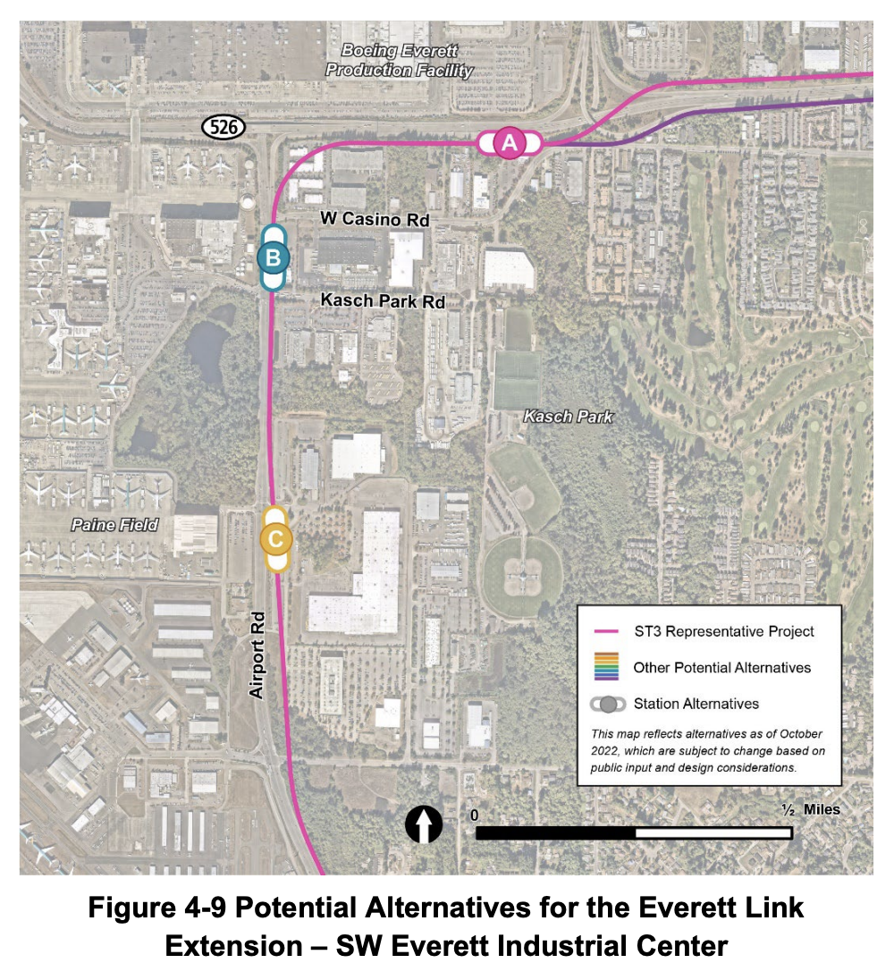
At SW Everett Industrial Center, the same three locations are still being studied. All of these options are abysmal due to the exceedingly suburban, car-first land use orientation of the area and miserable station locations. As The Urbanist documented before, this whole area is a ridership dead-zone with only 4% of area workers use the many excellent and more direct transit services that exist today. That surely isn’t changing in the future with these deeply flawed alternatives, barring some bonkers curveball like Boeing eliminating its hundreds of acres of car parking. Nevertheless, it’s important to examine these lousy station locations.
- Alternative SWI-A would place a station on the south side of SR 526 — a whole six blocks away from the Seaway Transit Center. A best case scenario for this station is a special shuttle bus to Boeing and nearby facilities and new set of pedestrian bridges to reach the transit center and Boeing campus. Ultimately it’s likely to perform incredibly poorly among local employees beyond walk-to-station riders from nearby apartments going somewhere else entirely.
- Alternative SWI-B would locate a station further south on Airport Road midway between W Casino Road and Kasch Park Road. It’s really hard to see how this station alternative does much if any better than SWI-A, but it would be more amenable to existing bus connections, including the Swift Green Line.
- Alternative SWI-C is the closest alternative to the commercial passenger airport. A station would be on Airport Road near 94th Street SW — a full six blocks north of the street that leads to the passenger terminal. It’s unclear why an alternative closer to 100th Street SW isn’t being studied, but if Paine Field ever becomes a major commercial passenger airport, putting a station so far north (an extra 2,000 feet) seems total malpractice. Given the current circumstances, it’s hard to image many suburban airport-going passengers will walk the 4,000 feet to the terminal, so the ridership potential is likely to be similarly awful as SWI-B.
Creating such terrible options here is a true feat, so maybe just offer that feedback to Sound Transit or suggest they literally burn cash instead. None of these are winners.
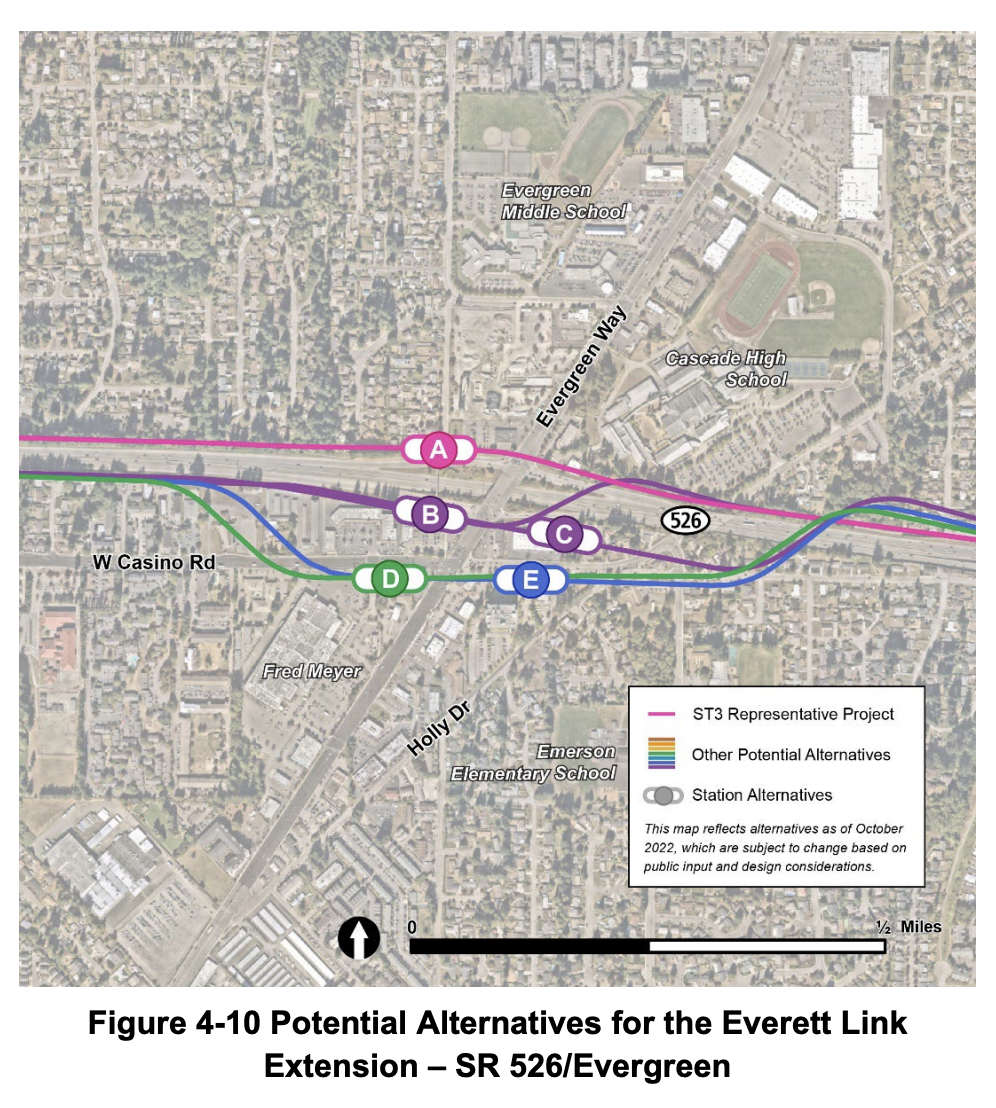
At SR 526/Evergreen, Sound Transit is still studying many alternatives.
- Alternative EGN-A would be north of SR 526.
- Alternative EGN-B would be immediately south of SR526 on the west side of Evergreen Way.
- Alternative EGN-C would also be immediately south of SR 526, just on the east side of Evergreen Way.
- Alternative EGN-D would be on the south side of Casino Road on the west of Evergreen Way.
- Alternative EGN-E would be again, south of Casino Road but to the east of Evergreen Way.
Given the way Sound Transit thinks they might construct these alignments, there is worry of substantial residential displacements. But like so many alignments the agency studies, it’s unclear why in-street elevated alignments are not seriously evaluated while highway-hugging often requiring displacements are. If this issue can be resolved, the clear winner is EGN-D and clear loser is EGN-A. Ultimately, a station on the west side of Evergreen Way is bound to do better given better transit connections. Taming Evergreen Way and Casino Road by eliminating car lanes could also do wonders, but like the SR 99/Airport Road station to the south, adding pedestrian bridges all across the intersection is the absolute minimum.
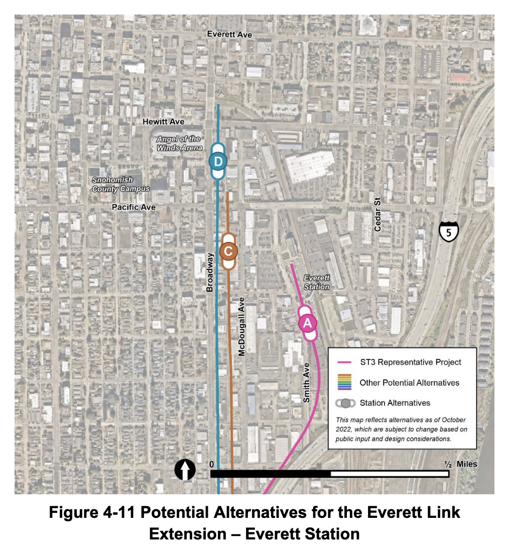
At Everett Station, the alternatives have been winnowed down to three. At this point, the non-Everett Station station alternatives are clear losers.
- Alternative EVT-D puts a station on the east side of Broadway immediately across from Angels of the Wind Arena, but five blocks from Everett Station. It also lacks bus connections and would require scores of property takings for reasons that just don’t make sense — again, just elevate the alignment and station in the middle of the street if this is going to be the chosen station location.
- Alternative EVT-C tries to split the difference between EVT-D and EVT-A by running light rail down the alley between McDougall Avenue and Broadway and locating the station on 32nd Street — two blocks from Everett Station. But again, this alternative would require many very expensive property takings. Unlike Broadway, these takings would be unavoidable by using the alley.
- Alternative EVT-A would route the alignment as close to I-5 as possible and then traverse parking lots to reach Everett Station approximately where the Swift Blue Line bus loop is located. This would ultimately require people to catch a short connecting bus to reach the city center, but that would be no different than it is today.
Transit-oriented development is varied among the alternatives, but EVT-A would preserve the most potential and, if designed well, could offer a logical expandability opportunity northward to better serve the city center with a proper station as well as North Everett neighborhoods and the hospital/college area. Studying an EVT-A location on the east side of the BNSF tracks may also be a worthy endeavor to this end.
So that’s the station and station area alignment alternatives. This is a lot to digest, so please take the weekend. On Monday, we will cover potential Operations and Maintenance Facility (OMF) North locations and the non-station alignment from SR 526 to Everett Station as well as the SR 99/I-5 alternatives issue in South Everett. That article will also include recommended feedback that should be directed to Sound Transit. See you then.
Sound Transit is accepting feedback on the Everett Link Extension alternatives through March 10th. An online open house is available with more materials and sections to provide feedback. Comments can also be sent via email to everettlinkcomments@soundtransit.org.
Snohomish County Leadership Group Squashes Alternatives to Paine Field Light Rail Routing
Elected Leaders Must Press Forward With Study of SR 99 and I-5 Everett Link Alternatives
Direct I-5 and SR 99 Alternatives Reemerge for Everett Link Light Rail