Councilmember Nelson abstained, citing cost worries
On Tuesday, the Seattle City Council passed a resolution supporting the development of freeway lids in the city. Passage of Resolution 32100 marks an important moment in the growing movement to reconnect neighborhoods that have been divided by freeways in Seattle. It also arrives at a critical time as the federal government increases investment in mitigating the negative impacts of freeways on U.S. cities through the Reconnecting Communities and Neighborhoods Grant Program and advocates like the Lid I-5 campaign step up community engagement and grow their grassroots movement.
“This is a big step forward. This resolution represents the first formal council action recognizing an interest in advancing, expanding our lid zones throughout the city,” Councilmember Andrew Lewis (District 7) said. “And I look forward to continuing this partnership with our partners at the Washington State Department of Transportation who are interested in syncing up these planning processes to take full advantage of these opportunities.”
Lewis, who sponsored the resolution, voted in support of the resolution alongside councilmembers Dan Strauss (District 6) and Lisa Herbold (District 1). Councilmembers Debora Juarez (District 5), Kshama Sawant (District 3), Teresa Mosqueda (At-Large) were not in attendance, while Councilmembers Alex Pedersen (District 4) and Sara Nelson abstained from voting on the resolution.
Pedersen refrained from making remarks, but Nelson said that while she was in theory supportive of lidding the freeway she chose to abstain because she did not feel she knew enough about the resolution and the potential impacts of lidding I-5 to make an informed decision at the time of the vote.
“I see the benefits [but] I also read the study findings. Some things say on and off ramps are particularly challenging. This would be more expensive, it would be challenging, it would be expensive, et cetera,” Nelson said. “So I think that because this is just the first step in a series of resolutions, I’m gonna take the time to bring myself up to speed about where potential funding partners are.”
The lid resolution comes on top of a 2022 decision by the Seattle City Council to adopt new amendments in support of freeway lids in growth and transportation strategy sections of Seattle’s Comprehensive Plan, which is slated to receive a Major Update by the end of 2024. A draft of the Major Update is expected to be made public by October 2023.
Building on the Lid I-5 Technical Feasibility Study
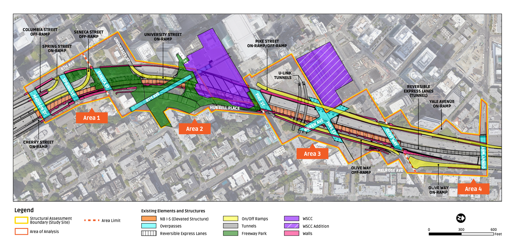
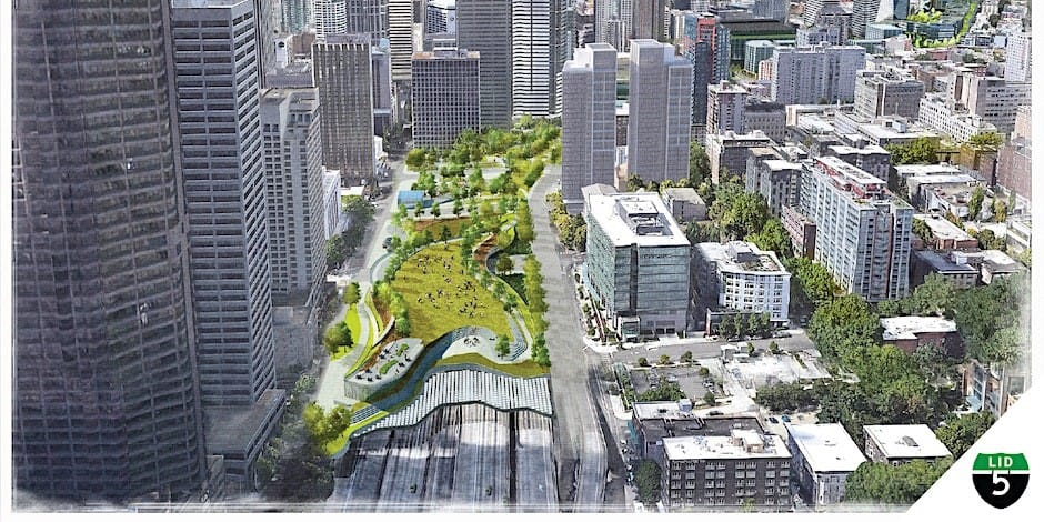
The study findings referenced by Nelson were the results of the Lid I-5 Feasibility Report, published in late 2020 by engineering firm WSP and the Seattle Office of Planning and Community Development (OPCD). The report found that lidding I-5 in Downtown Seattle was technically feasible in the study area between Madison Street and Denny Way, and it presented concepts for what a freeway lid could look like, what could be built on it, potential cost figures for the different development scenarios, and an outline of next steps.
Cost figures in the report ranged from $966 million for a public park concept to $2.3-$2.5 billion for a high density development scenario. A hybrid option including both development and public open space was projected to cost between $1.3 and $1.5 billion.
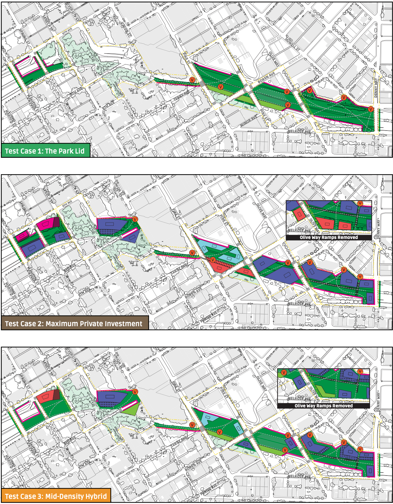
WSP’s cost calculations, however, had to take into account current parking requirements for new development in the lid study area. Noting there would not be enough space to accommodate all the required parking on the lid, they planned for 10% to be built on the lid and 90% to be built nearby in what they called a parking reservoir, although they did not identify where it would be located.
In high density Test Case 2, which included the removal of the Olive Way ramps, this translated into 190,000 square feet of parking (1,100 spaces) on the lid and 1.4 million square feet of parking (9,700 spaces) nearby. For hybrid Test Case 3, also with the removal of the Olive Way ramps, 64,000 square feet of parking (450 spaces) would be built on the lid, and 580,000 square feet of parking (4,000 spaces) nearby, according to WSP’s calculations.
Acknowledging that parking plans contributed significantly to the cost of development scenarios on the lid, WSP stated that “parking demand at the time the lid is designed, would be a major factor for development economics.”
Private investment could also play a critical role in the development of future freeway lids, as Councilmember Dan Strauss highlighted in his remarks in support of the resolution, describing how “this is not something where we need to dump a lot of public money into because there is a private market to make this happen.”
“If you look at Washington DC at the Capital Crossings project, they were able to add seven acres in downtown that was I believe completely privately funded, and what this did was it reconnected the grid and it created new business and new buildings that were all LEED certified,” Strauss said.
“The amount of just these seven acres in DC are estimated to generate $40 million in annual property tax revenue. So it’s not just a nice thing to have when we are able to privately fund these projects, we’re also able to reap the benefits while reconnecting our city,” he continued.
Lids for the U District, 130th Street Station, and South Park?
While Strauss said that he was enthusiastic about the prospect of exploring lids in the Downtown study area and also between NE 45th and 50th Streets in the University District, where the Lid I-5 North campaign led by the U District Partnership has taken root, Strauss also pointed out that he would like to see the concept explored in other areas of the city, notably at NE 130th Street where a light rail station is scheduled to open in 2026. As an infill station, the 130th Street station will have no onsite parking, and safe access for pedestrians and cyclists remains a concern.
The federal government could also be a potential funder for future lid projects. In his public testimony before the resolution vote, Lid I-5 campaign co-chair Scott Bonjukian referenced how the Seattle Office of Planning and Community Development (OPCD) is currently in the process of applying for funding through the Reconnecting Communities and Neighborhoods Grant Program, part of the Biden Administration’s Bipartisan Infrastructure Law. In the 2023 cycle, the program will award $185 million to 45 communities across the U.S. and the funding may be used for planning, technical assistance, and capital construction costs.
Funding for the Lid I-5 project could be used to complete the series of next steps outlined in the Technical Feasibility study. In an article with The Stranger, Bonjukian said he felt that if work continues to advance he could envision “boots on the ground in 10 years.”
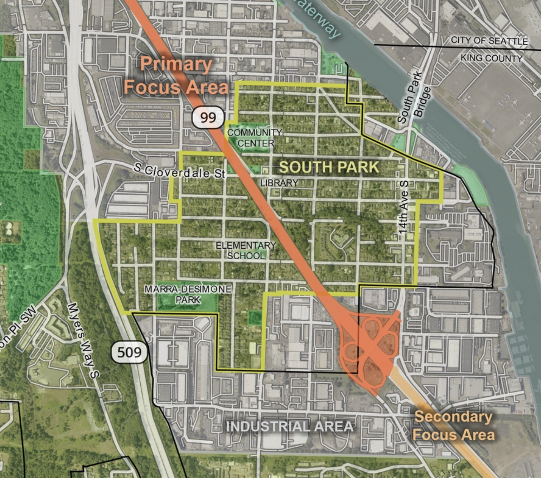
If Lid I-5 is awarded funding by Reconnecting Communities, it won’t be a first for Seattle. In 2022, OPCD was awarded $1.6 million for the Reconnect South Park project, which is exploring how to improve community connectivity near SR-99 in the South Park neighborhood. A Community Vision Report, Equitable Development Plan, and detailed traffic studies are expected to be completed and made public sometime in 2025-2026, according to the Reconnect South Park timeline.
The Washington State Department of Transportation (WSDOT) is currently working on an I-5 Master Plan, which includes a study of freeway entrance and exit ramps. Because ramp configuration will play a critical role in the design of future freeway lids, information gathered in this study will be integral to lidding I-5 in the future. So if the Lid I-5 project succeeds in being awarded funding by the Reconnecting Communities and Neighborhoods Grant program during this round, the timing would work well for moving the project ahead.
With momentum building around lidding freeways in Seattle, the Lid I-5 campaign is stepping up its community engagement efforts. On September 13th, it will be hosting a Reconnections Social at Town Hall, 5:30-8pm (program at 6pm) with Councilmember Andrew Lewis, Representative Nicole Macri (D-43rd Legislative District), and Rebecca Bear, CEO of the Seattle Parks Foundation. (Register online here) Additionally the campaign is encouraging people who live near I-5 to complete a public survey sharing their experience.
Natalie Bicknell Argerious is a member of the Lid I-5 steering committee.
This article was updated at 9am, 9/6/23 to reflect that Rep. Nicole Macri and Rebecca Bear, CEO of the Seattle Parks Foundation, will be speaking at the Reconnections Social at Town Hall.
8 Takeaways from Seattle’s Lid I-5 Feasibility Study
UW Students Are Investigating a Proposed U District Freeway Lid