The Seattle Department of Transportation (SDOT) is advancing work on a small but incredibly important segment of protected bike lane along Yesler Way, connecting the center city bike network with the soon-to-open signature waterfront trail. Though filling a gap of only about 600 feet, the project will be the sole direct and protected connection planned between the facilities.
In 2022, the Office of the Waterfront and Civic Project installed a very short stretch of bike lane on Yesler Way near Alaskan Way, with an awkward diagonal crossing for people biking toward downtown. The odd facility illustrated the degree to which making it easy for people on bikes to get to the $806 million waterfront project had been an afterthought.
Despite the fact that Downtown’s signature bike facility on Second Avenue was only a few hundred feet away, the Seattle Department of Transportation (SDOT) confirmed at the time that it didn’t have plans to bridge that final gap without paying for a costly upgrade to the traffic signal at First Avenue and Yesler Way, with no funding identified for that.
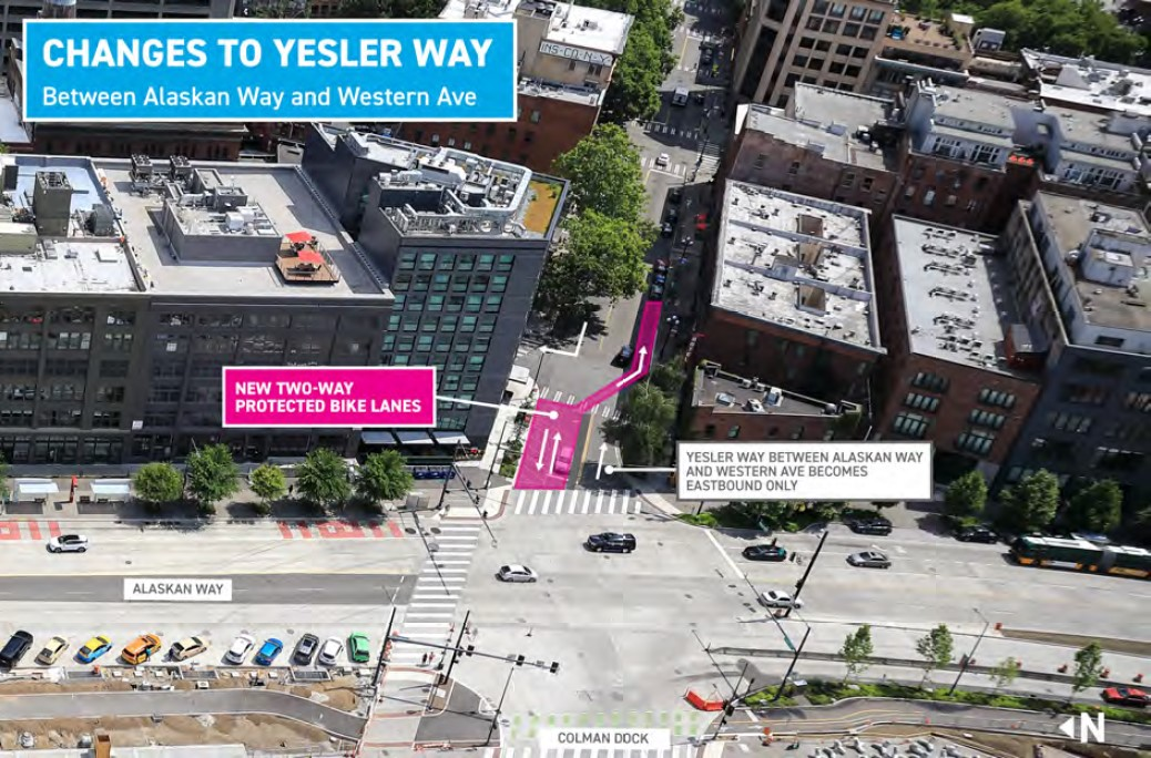
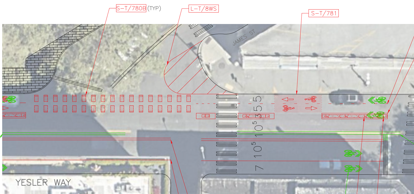
Now SDOT has announced that they have been able to advance a design that fills the gap without replacing the outdated signal that matches the historic district: by restricting turns across the bike lane.
“The project will add turning restrictions prohibiting vehicles from making right turns from westbound Yesler Way to northbound 1st Ave S, and from making left turns from eastbound Yesler Way to northbound James Street,” the new project website states. “This allows the project to provide a protected bike lane without making changes to the signal at 1st Ave S and Yesler Way.”
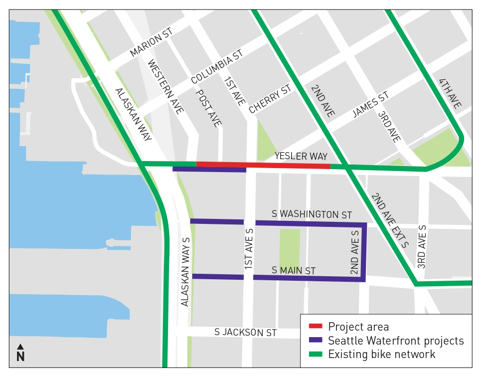
Plans for the connection have already been advanced to 30% design, with SDOT saying that it wants to complete the project by the end of this year, in conjunction with the upgrades to other east-west streets in Pioneer Square that are underway right now, including the conversion of Washington and Main Streets to one-way couplets.
As part of the design, the curb at the awkward diagonal intersection of Yesler and James Street would be extended a bit, but that intersection will likely remain the trickiest part of the route, with a long stretch where people on bikes will be exposed to turning drivers who may disregard signage. But having this connection in place will be infinitely preferable to having scores of people biking trying to access the waterfront trail without any safe way to get there.
The new waterfront trail will ultimately be one of Seattle’s most popular bike routes, a fact that makes design choices like the narrow width and its myriad of twists and turns from Pioneer Square to the Seattle Aquarium more frustrating. As its grand opening approaches, actually ensuring that it’s a part of the downtown bike network is critical.
The trail still includes a tantalizing connection to central Downtown at Spring Street, which won’t actually connect to any bike facilities and will instead just dump riders out onto traffic lanes, a clear missed opportunity to connect people with a fairly direct route to Pike Place Market, using Western Avenue, without having to use any of the elevators further north.
On the north end of the waterfront project’s boundaries, a short bike lane on Bell Street is set to start construction later this year, but that route is still set to involve having to share space with vehicles on a narrow curbless street to get to the rest of the downtown bike network. As part of the next transportation levy, SDOT plans a repaving of Elliott and Western Avenues, a project that will likely involve some resizing of those oversized streets and adding safer bike facilities.
Despite the fact that actually ensuring that the waterfront bike trail would be accessible to the majority of people who get around by bike in Seattle’s center city was an afterthought for the waterfront project as a whole — even with plans being in the works for over a decade — this small project will go a long way toward correcting that oversight.
Seattle Waterfront Park Project Finally Enters Its Home Stretch
Key Bike Connection to Seattle Waterfront Still Remains Unfunded