The armory in Interbay could find itself revamped from a military installation to a new urban district. In 2018, the Washington State Legislature tasked the Washington State Department of Commerce (Commerce) to commission an advisory committee to chart the course on future of redevelopment. To make this work, the Washington Army National Guard would move to a new location near North Bend, vacating the Interbay site, which would be redeveloped and potentially fully fund the move. The advisory committee is composed of several current and past elected officials as well as development interests and Washington Army National Guard, including:
- Representative Gael Tarleton (D-Seattle);
- Senator David Frockt (D-Seattle);
- Port of Seattle Commissioner Courtney Gregoire;
- Former Governor Gary Locke (D-Washington);
- Colonel Adam Iwaszuk of the Washington Army National Guard;
- Brian Lloyd, Vice President of Beacon Development; and
- Doris Koo, a community development and affordable housing expert.
The Interbay Armory Site Needs a New Home
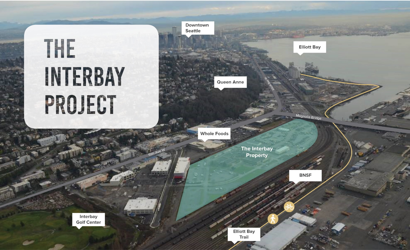
The armory site has served a variety of military uses since its inception during World War II as a Navy supply depot. In the 1970s, the site was handed over to the Army and has served the needs of the Army National Guard with a field maintenance shop, readiness center, and vehicle and supply storage. The buildings on the 9.74-acre site compose approximately 101,200 square feet.
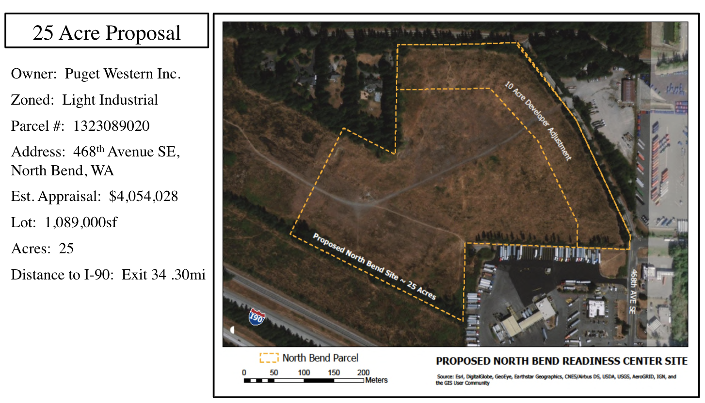
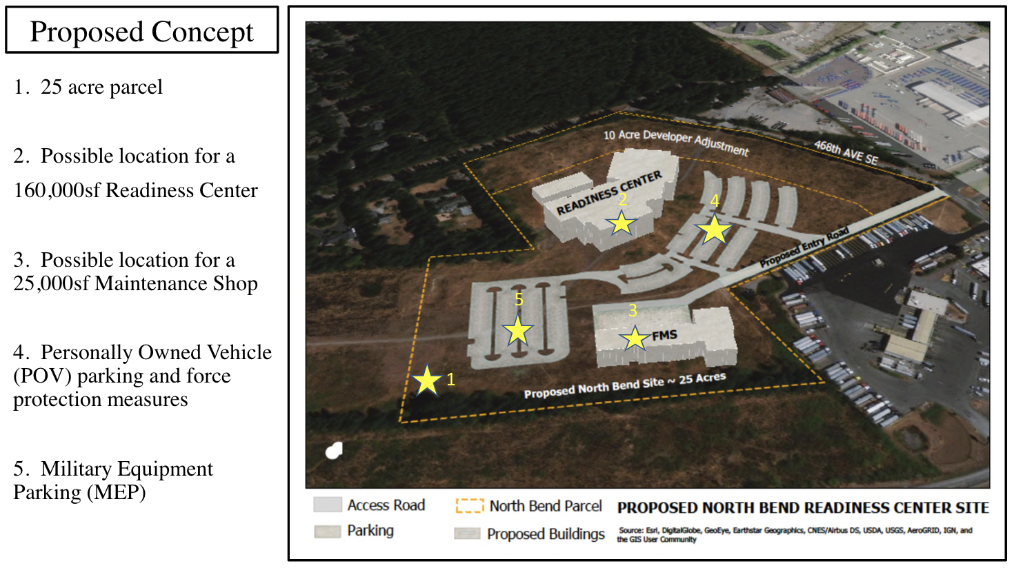
Analysis by the Washington Army National Guard suggests that the site is valued at $32 million in 2017 dollars, given its light industrial zoning. Replacement value of the the site facilities is estimated to be approximately $85 million. The Washington Army National Guard would like to relocate to a new site by 2025, which has been identified near North Bend. The site is approximately 25 acres in size and would include a 172,500-square foot readiness center ($65 million), 25,700-square foot field maintenance site ($18 million), and 9,600-square foot storage facility ($2 million).
Interbay Armory Site Redevelopment Challenges and Vision
The site presents some challenges for redevelopment, especially for visionaries who argue that it should become the epicenter for a dense mixed-use ecodistrict.
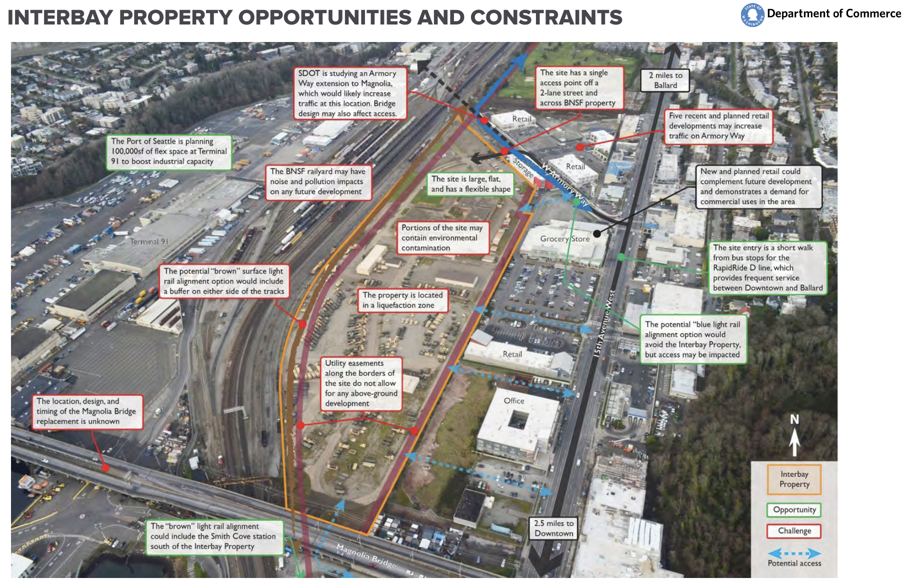
For starters, the site is hemmed in between the BNSF railway, Magnolia Bridge, and large development sites facing 15th Ave W. The site currently has only one access point off of W Armory Way, making it hard to reach from the north, south, east, and west–although great street connectivity is suggested in the proposal. The site is designated as a flood hazard area, liquefaction zone, and is at risk of mass inundation from sea level rise due to climate change.
And on top of this all, zoning of the site is Industrial General 2 with unlimited height (except that there is a 45-foot height limit on commercial uses) and it falls within the Ballard-Interbay-Northend Manufacturing Industrial Center. Changing zoning to enable more mixed uses may be a big lift given regional policies on industrial lands, despite the fact that light rail is slated to serve the area by 2035. But some have argued, despite the challenge, it’s time to reform industrial lands policy in Seattle.
Nevertheless, the zoning of the site is somewhat flexible allowing a range of industrial, manufacturing, commercial, storage, and office uses. It might not be out of the realm of possibilities that another Expedia-like campus could find itself on the site, assuming zoning does not change.
Planners and policymakers may find it desirable to rethink how the area should function, given that a major light rail investment is on the way even with the known site challenges and hazard risks.
Concepts that Commerce is actively considering include market-rate housing, affordable housing, commercial and industrial, and open space. Contracted consultants have researched case studies and developed six high-level options that mix and match these priorities. The options center around two extremes, with one attempt at a Goldilocks just-right option:
- Option 1, the Market-Rate-Focused Alternative, would net the state the highest value of property ($115 million) by emphasizing market-rate housing first, commercial and industrial second, and open space third.
- Option 5, the Social Housing Centered Alternative, would develop the site with affordable housing and open space, recuperating little to no cash for the state.
- Option 2, the Breakeven Blend, would balance all uses and aim to net the state enough to breakeven on property value at $95 million, perhaps making it the most desirable option from Commerce’s perspective.
Community and stakeholder feedback will help guide Commerce charting a path forward on redevelopment of the site, but timing to move ahead on development is tight given the 2025 target opening of the new armory site in North Bend and need for funding.
Aside from the aforementioned constraints, the Seattle Department of Transportation is still grappling with how to rebuild the Magnolia Bridge. Several concepts have been put out there, such as making a new bridge crossing that would connect into Armory Way W, widening Dravus St W, and replacing the Magnolia Bridge. Depending upon what is chosen and implemented, that could further affect the armory site negatively, positively, or not at all.

Port of Seattle Plans Interbay Redevelopment, Too
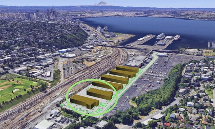
In tandem with this, the Port of Seattle is planning a major redevelopment of their properties just west of the BNSF railway. According to Queen Anne News, the Port of Seattle has set aside $4 million to start planning work on the first phase of redevelopment at Terminal 91, a very large tract of land north of the Magnolia Bridge and east of 21st Ave W.
“The Port’s 2016 Real Estate Strategic Plan proposes the creation of 700,000 square feet of new maritime industrial building space in Terminal 91’s Uplands area,” Queen Anne News reported in late February. “Phase 1 calls for the creation of two 50,000-square-foot light industrial buildings to accommodate maritime and fishing-related manufacturers and suppliers as outlined in the Port’s 2019-23 capital improvement plan.” A second phase could follow to construct another 300,000 square feet of building space, and if successful, a third phase could be commissioned to build out another 600,000 square feet.
Whether or not the Port of Seattle’s redevelopment of Terminal 91 will integrate into the urban fabric of Magnolia is too early to say, but the Elliott Bay Trail, a critical connection for bicyclists and pedestrians, passes by the site, and the site could benefit, too, from the future light rail system. The planned set of uses appear to be industrial and maritime in character, perhaps dashing any hopes of it being ampart of a dense mixed-use ecodistrict. The Port of Seattle projects a major need for the industrial and maritime uses in the years ahead, as vacancies remain low, but, as the planning effort moves ahead, it’s possible the Port of Seattle will consider a course change.
Looking Ahead
Commerce intends to provide a recommendation to the Governor and Washington State Legislature by November 15th. Three additional open houses will occur throughout the spring, summer, and fall in addition to several advisory committee meetings to guide the project and develop a formal recommendation.