Plans for a protected bike lane on Martin Luther King Jr Way S between Mount Baker Station and (still under construction) Judkins Park Station are moving forward with construction still anticipated to start in 2023. This key connection is one of several routes moving forward to begin to connect the southeast quadrant of Seattle to Downtown and other neighborhoods beyond. Downtown and the North End saw the lion’s share of new bike facilities in the first few years of the Move Seattle Levy. It might not have happened if not for the sale of the Mercer Megablock property, which provided a cash infusion to the running-out-of-steam Bicycle Master Plan program.
The project has just reached 60% design, which means most of the design details are fully fleshed out. The Seattle Department of Transportation (SDOT) has a survey up through May 20th to seek feedback on the current plans.
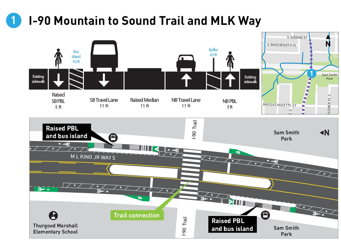
The most important segment of the project is the segment that intersects with the Mountains to Sound trail at I-90. There, transit riders will transfer between the workhorse Route 8 bus (and Route 4) and Judkins Park Station just down the trail at 23rd Avenue, and people riding bikes will mix with all modes as they switch between the bike lane and the trail. The current design shows floating bus stop islands in both directions on MLK Way here, with the bike lane raised up to the same height as the sidewalk and bus island to signal to bike riders that they’re entering a mixing zone. Buses will stop in-lane, with the center turn lane blocked off to prevent impatient drivers from passing the bus. There are also ramps planned to make the transition from the bike lane to the trail easier and reduce conflicts in the crosswalk.
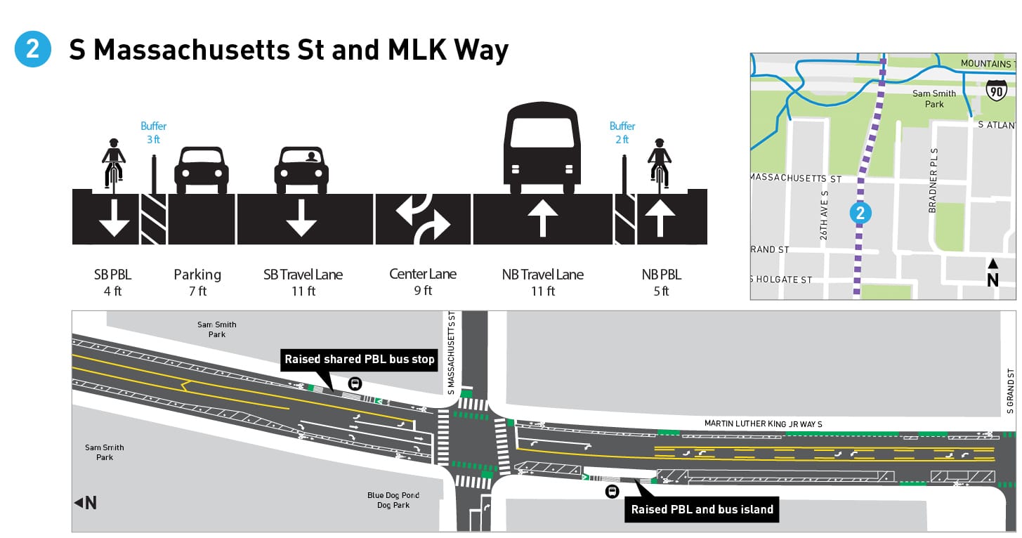
To the south, the southbound bus stop at S Massachusetts Street will be another floating island, but the northbound stop won’t have one — bus riders will enter and exit the bus directly into the bike lane. This is a bus stop design that SDOT has begun to employ more and more often when there are space constraints, but it’s essential to note that space is tight because three southbound travel lanes have been prioritized.
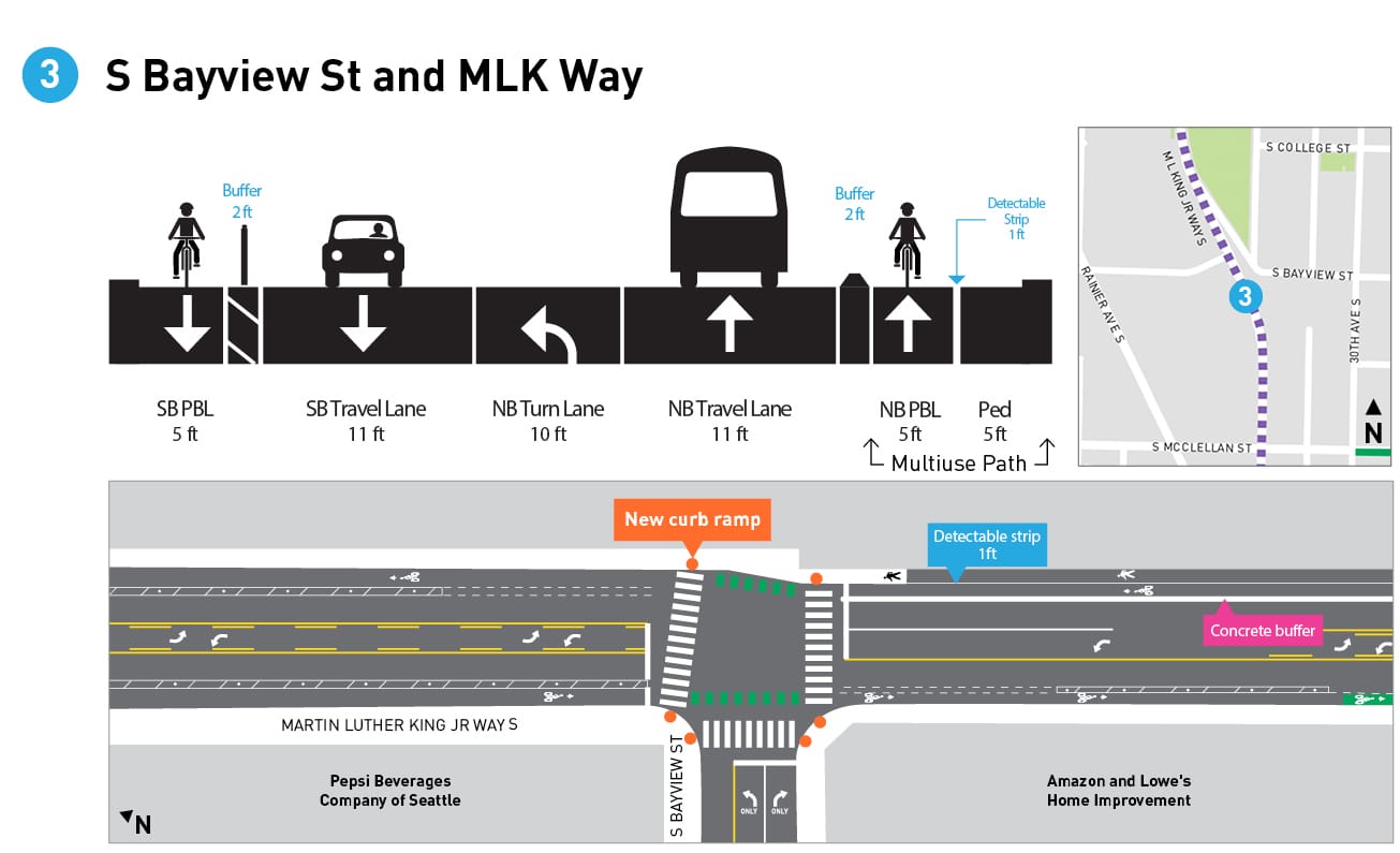
At S Bayview Street, both the northbound and the southbound bus stop take over the bike lane entirely, with the bus stop pulling up to the curb. This increases the likelihood that the bike lane will get blocked by other vehicles. It’s unclear why an in-lane bus stop can’t work here also, given the plans for further north.
Plans for Bayview also show another unique feature: a new path for people walking or rolling. Currently there isn’t a sidewalk on the east side of the street south of Bayview; this project will create space for a pedestrian path alongside the northbound protected bike lane. With that comes the only planned concrete protection for the bike lane in the entire project, stretching from Bayview to McClellan Street, the rest of the corridor will have plastic posts in the buffer for the bike lane. It is great to see a protected bike lane project taking steps to disconnect a gap in the pedestrian network as well.
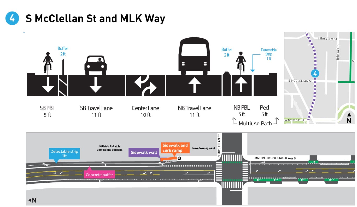
Another out-of-lane bus stop is planned northbound at McCellan Street. McClellan has existing paint bike lanes that start at 30th Avenue but it looks like there are no plans right now to connect to the planned MLK lanes, leaving a frustrating gap.
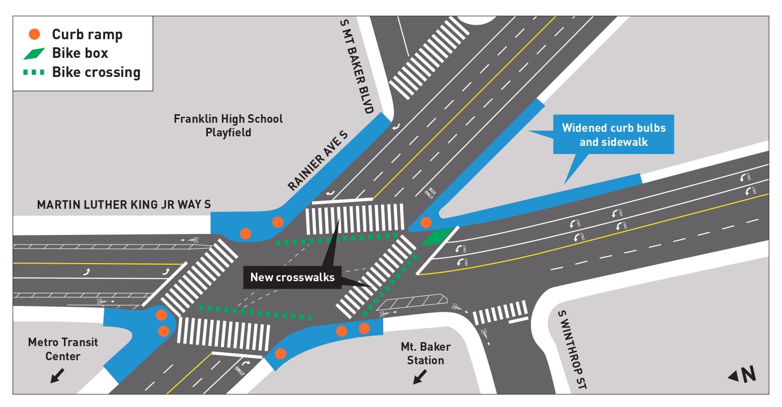
The bike lanes will not continue past Rainier Avenue, except for a short bit of paint to direct southbound riders onto Winthrop Street. People headed to Mount Baker Station will probably use the curb ramp to get onto the sidewalk at that point.
SDOT is folding pedestrian improvements at Rainier and MLK into this project as one phase of the Accessible Mount Baker project, with the biggest change being new marked crosswalks across the two legs of the intersection where they don’t currently exist due to the pedestrian overpass. Sidewalks are also getting widened and no-right-on-red restrictions added; most of these improvements are planned for 2022, a year before the protected bike lane. The vision of the overall Accessible Mount Baker plan of completely reconfiguring the intersection and surrounding area remains dramatically underfunded but isn’t one we should lose sight of.
Will this protected bike lane extend further south to connect more of the Rainier Valley? Likely not for a while. The 2021 budget does include money to study the feasibility of adding a bike lane to MLK Way between Rainier and S Henderson Street in Rainier Beach, but no construction funding has been identified yet. There are likely a lot of people who would not prefer adding a bike lane to that segment of MLK, with high volumes of fast-moving traffic, over Rainier Avenue, which has seen significant reallocation of roadway space in recent years. Add this to the list of debates that will be at the center of the next transportation levy.
You can take the survey on this key missing segment in Seattle’s bike network until May 20th.