However, a recent fatal crash underscores the need for safer conditions for people biking in the corridor.
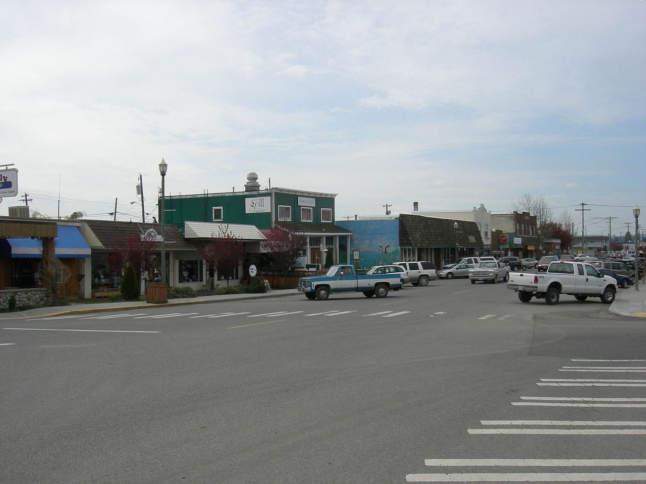
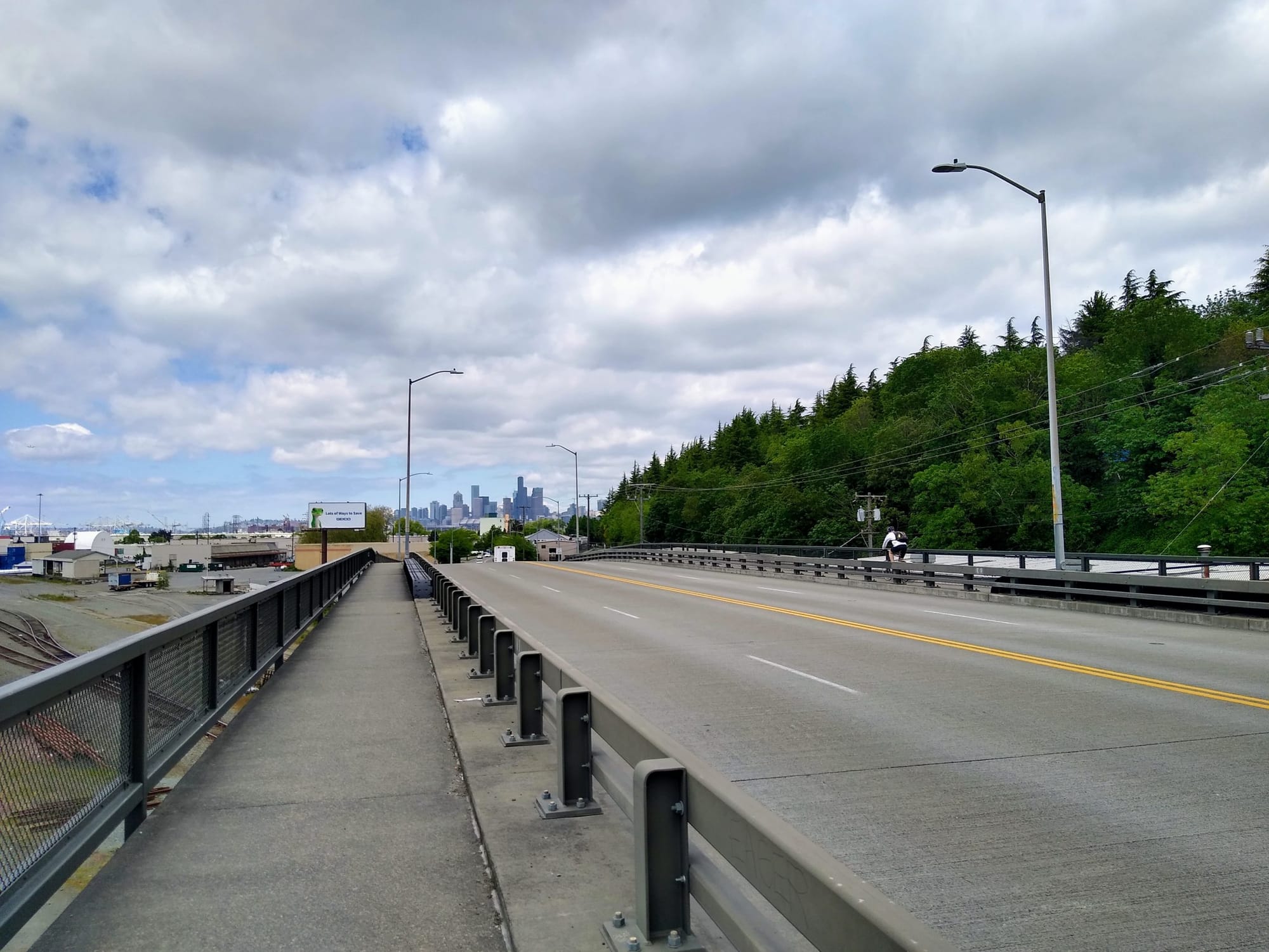
Some of the most dangerous roads in Seattle are all grouped together in the SoDo neighborhood, where heavy freight traffic serving industrial businesses and a network of wide streets form an area all-but-completely hostile to anyone not in a car. Sidewalks in SoDo are unpleasant places to be, and there is virtually no space allocated for people on bikes. Apart from the connection along East Marginal Way to the West Seattle Bridge trail, the only dedicated space to bike in SoDo is a multi-use path next to the Link light rail tracks, away from businesses and disconnected from any other facilities.
The Seattle Department of Transportation (SDOT) has started planning a safe bike route through SoDo south to Georgetown, another area of the city with a clear lack of safe bike facilities. This project is one of several in planning right now as a part of a slate of projects intended to get the department closer to the goals it outlined to voters in 2015 when it was promoting the Move Seattle levy.
The latest fatal crash in SoDo, on May 11th, in which a person biking on the sidewalk of 4th Avenue S near Holgate Street was struck and killed by a driver exiting a parking lot, has put into stark relief this lack of safe facilities. Wide streets are a persuasive problem in the area and have a documented history of creating deadly conditions for people biking.
4th Avenue S is eight lanes wide through SoDo, and Holgate Street, located a few blocks away, is five lanes wide. Last January, Antonio Tiongco was killed while biking across Holgate Street, and his death is not the only to report. In 2017, Celso Diaz was killed by a driver at the intersection of 1st Avenue S at S Andover Street, on a stretch of 1st Avenue S that extends to seven lanes wide. Months earlier, another person on a bike was seriously injured in a crash at 1st Avenue S and S Spokane Street. As alarming as these examples are, they are far from creating a complete picture of the lives devastated by traffic violence in SoDo.
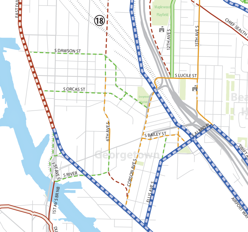
There is a lot we don’t know about the SoDo to Georgetown proposal yet — including what exact type of bike facility will be and what side of any street it will be on — but SDOT has confirmed that among two routes being considered, a 6th Avenue S connection to the SoDo trail is considered the “most feasible” at this point.
Georgetown is separated from SoDo by a sea of train tracks known as the Argo train yard. There are only a few bridges across the tracks, at 1st Avenue S, 4th Avenue S, and Airport Way S. Both options being considered right now by SDOT use the Airport Way bridge, which is the newest of those bridges and offers the most space for people walking and biking.
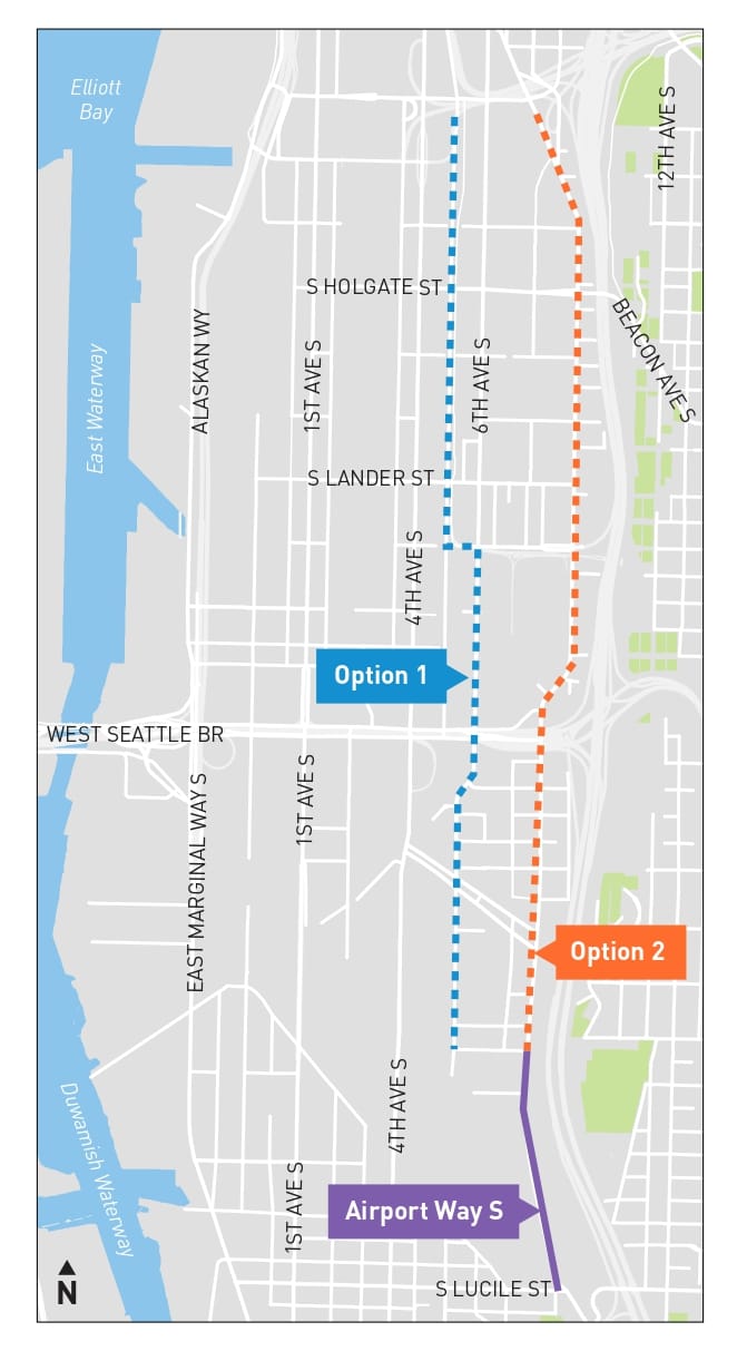
Option 2 would continue on Airport Way all the way north to Royal Brougham Way. This route would be the most direct and easy to understand, but people on bikes would be sharing space with a lot of fast moving vehicles without significant traffic calming on Airport Way, making it unlikely to be fully funded. In 2014, a proposal to create a protected bike lane on Airport Way was included on SDOT’s bike lane implementation plan, but it was removed; the Bicycle Advisory Board was told this was due to the fact that Airport Way is considered an emergency alternative to I-5 and can’t have its capacity reduced. So, there may be more systemic barriers to this option.

Option 1, which SDOT says is currently most feasible, would jog over to 6th Avenue S at S Alaska Street, just north of the bridge, and continue north on 6th Avenue S. This street has much lower volumes of traffic than Airport Way. Currently the street has a lot of cars parked illegally on it, sticking out into the sidewalk area. Again, we don’t quite know what SDOT is proposing here, but the wide intersections at both S Spokane Street and S Industrial Way, which both act more like freeway exits than city intersections, will be particularly tricky to navigate.

The primary benefit of the 6th Avenue S alignment is that it would provide the direct connection possible to the SoDo trail, making this off-street, separated bike facility much easier to access. Between S Forest Street and Royal Brougham Way, the route would run along this trail.

Here are some related points that SDOT has confirmed about the project.
No connection through Georgetown itself is planned
A key component of any safe route between Georgetown and Downtown is clearly the alignment through Georgetown itself. However, SDOT has no current plans to fund a facility running any further south than S Lucile Street at the south end of the Airport Way bridge. A protected bike lane that continues on Airport Way S is what is called for in the 2014 Bicycle Master Plan, but Mariam Ali of SDOT has confirmed that “continuing on Airport Way S has severe traffic and parking impacts as well as signal work that is not funded.”
“There is space for a rail with trail route following a spur track that runs through the heart of Georgetown as called for in the neighborhood’s open space plans, but this would also be expensive and must be left to a future project,” Ali said.
This year, construction starts on the Georgetown to South Park trail, which will run along Albro Place, Ellis Avenue S, and East Marginal Way to the north end of the South Park Bridge. Even that facility won’t fully connect to Airport Way, the main commercial district in Georgetown. But if a facility were to be constructed on Airport Way, the Vale Street “festival street” would serve as the connection between the two. That work has been pushed off into the future, with a contentious parking battle likely.
No connection to Downtown is planned
Both options on the table for a “Georgetown to Downtown” protected bike lane aren’t planned to go any further north than Royal Brougham Way, located far from downtown. SDOT did tell us that they are considering an off-street path on Royal Brougham Way that would connect back to 6th Avenue S; however, that street is currently closed long term north of Royal Brougham due to a permit issued to King County for operation of an enhanced shelter. King County has stated that it plans to extend operation of that shelter.
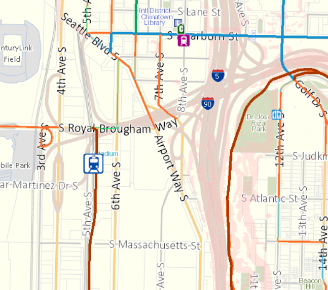
Before King County had announced those plans, the two massive blocks on either side of 6th Avenue S were moving forward toward redevelopment as a large office complex. As part of those plans, protected bike lanes on either side of the street were planned at minimal cost to the City. Now SDOT tells us that this project has been paused. “We will be working within SDOT and with the developer to see what access is possible during this time,” Ali said.
If that 6th Avenue S facility did come together, it still wouldn’t connect to any other separated bike facilities. “At this time we are not including improvements farther north than Seattle Boulevard, but a future project may upgrade the basic bike lanes to protected bike lanes.”
Thus the current plans for the Georgetown to Downtown protected bike lane would not serve most of Georgetown or connect to Downtown. The primary factors pushing for a 6th Avenue S alignment all seem to stem from an attempt to create a route that won’t really take much space away from drivers or create disruptions. Additionally, one of the project goals as listed on its website is to “retain as much parking as possible along the corridor.”
“Do I think that people need to be able to bike through Sodo? Yes. On every street? No. There need to be safe corridors,” Erin Goodman, the executive director of SoDo’s Business Improvement Area, told David Kroman of the Seattle Times this week. Of course, if people need to access businesses and services in SoDo, an out-of-the-way bike connection isn’t helpful. Shunting people onto side streets to preserve parking spaces goes against the spirit creating conditions in which people can bike safely on the streets they choose — and need — to use.
SDOT says it’s currently planning for a budget of $4.75 million for the Georgetown to SoDo project, and has funding on hand for planning and design, but not construction, while regional grants are being eyed for the remainder of that cost. As the City pursues these funds, it should work to ensure that the investment into this treacherous corridor truly improves safety conditions and makes biking a viable choice for traveling within and through Georgetown and SoDo.
What the Georgetown to South Park Trail Will Look Like
Georgetown Community Development Authority Seeks Input on Plans for 150 Affordable Homes