“Seismic” buttons in Seattle’s elevators hide ubiquitously in plain sight. When I was new to the city last year, these buttons were a reminder that I had moved in beside a quiet danger. I was intrigued by other reminders. Signage announcing seismic improvements to elementary schools. Housing built beneath slopes obvious to be serious landslide hazards. Conversations with friends veered into zombie-apocalypse territory almost instantly. We would survive with kayaks, liquor and scaling buildings. When I would broach the science around Seattle’s geological threats, plans trended back towards the liquor.
Seattle ranks highest among the nation’s cities for risk of exposure to a major disaster. In spite of this, preparedness is an ongoing challenge among residents, with many not understanding all of the threats that exist and the most important preparations to make.
A layer cake of geology nightmares
Most hazards faced by the city of Seattle result from the area’s geology and climate. The blend of conditions – high-density urbanization with high seismic and volcanic activity, steep terrain, and so much rain – means that hazards do not occur alone. An event in one category should be expected to trigger events in others.
The result is what I call a “geology nightmare layer cake.” Imagine a hastily conceived science fair project of mud, gravel, and cut-up sponges on a wobbly table, and then imagine what you would have to do to get something solid to stay put on top while standing in the shower. Two ill-conceived years of engineering geology school had accustomed me to the hidden perilousness of such challenges. More interestingly, it accustomed me to the people who think about them for a living. One professor, a man with an infectiously sunny disposition, would sketch undesirable soil profiles on the chalkboard and explain short-sighted building mistakes via stick-figure orphanages falling into sinkholes. This was a class filled with real photos of people’s cars and homes partially buried in swamps. It was a good class.
Seattle’s layer cake starts with a cracked plate. The seismic risk under the city itself comes from the Seattle Fault Zone, which extends from the Cascades to Whidbey Island, running directly under the city and the Sound. Earthquakes of historic proportions occur a few hundred years apart, but can be wildly destructive in the span of a few minutes’ shaking. Many residents remember the Nisqually quake of 2001, a magnitude 6.8 earthquake which caused 40 seconds of shaking and injured 200 people. Some may also recall the 6.5 magnitude quake of 1965 which killed three people and caused roughly $12 million in damages and closed the state Capitol building in Olympia due to damages.
In spite of the danger, our region owes much to these crustal movements: mountain ranges come from “wrinkling” under the stresses of tectonic pushing and pulling. The dumbfounding transition from high desert to rainforest over the Cascades is owed to our mountains’ rain shadow effect, in which a mountain range acts as a kind of “scraper” for directing atmospheric moisture downwards to one side.
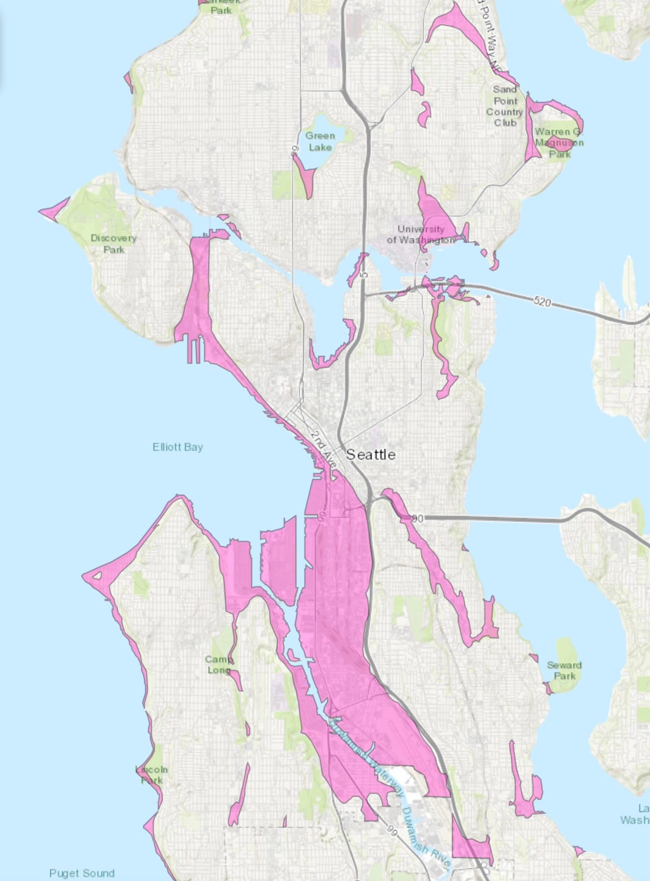
Atop our broken cake plate is a crumbly mess of dessert. The rock and soil under our pavement is a combination of loose gravel and sand deposited when much of the area was covered in glacial ice, as well as finer layers of mud deposited as the glaciers melted and retreated northward. There are also peat deposits, which form in wetlands when plant matter cannot completely decay and instead turns into a layer resembling a soggy sponge. These conditions make many areas in the city vulnerable to liquefaction. Liquefaction is a process in which wet compacted sediment can turn from solid to quicksand when shaking begins, and back to solid again once it stops, trapping submerged objects, vehicles, and even segments of buildings.
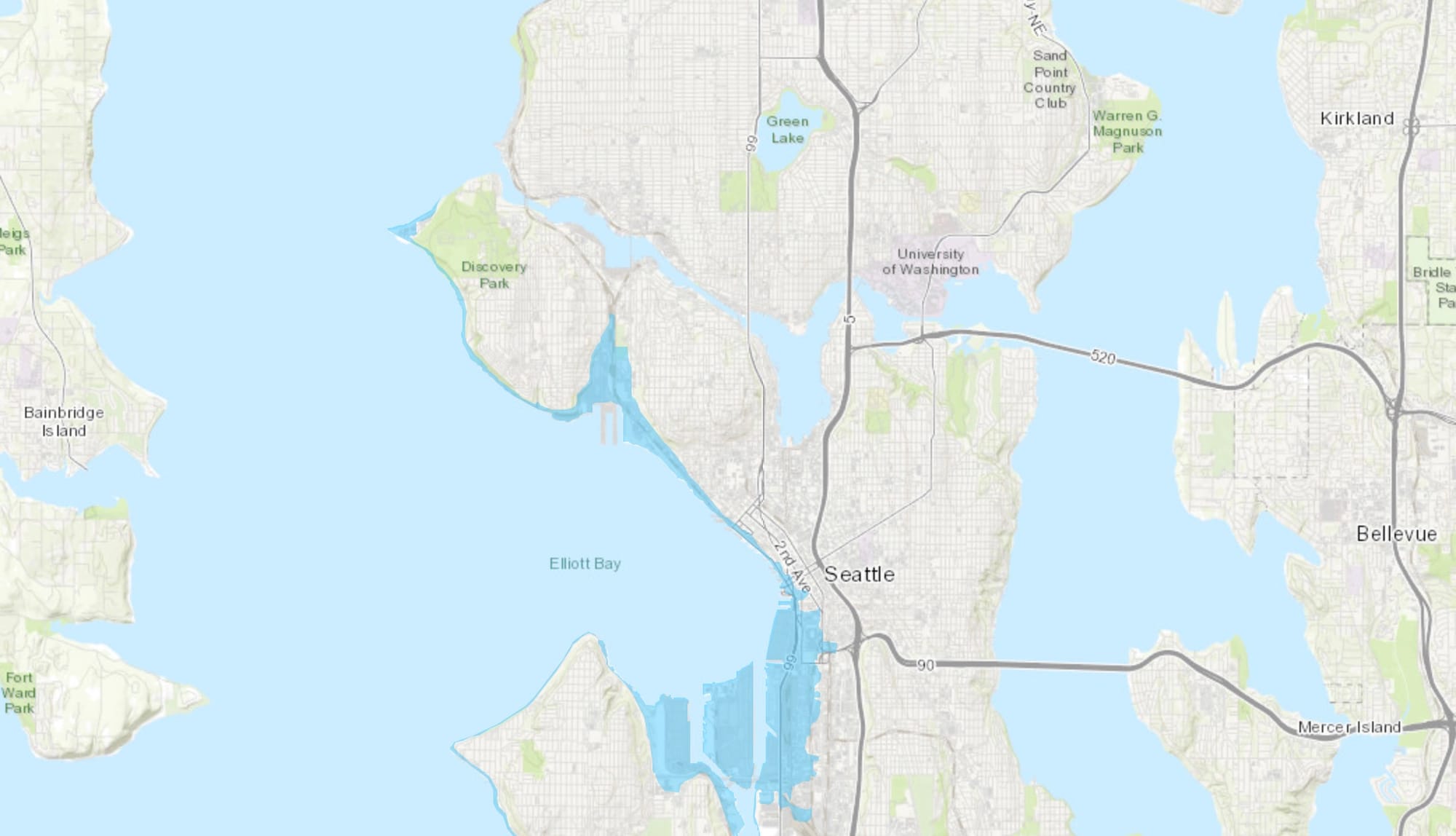
Many neighborhoods immediately surrounding Elliott Bay are also at risk for tsunami inundation after an earthquake. These include the low-lying areas of Magnolia, Interbay, Queen Anne, downtown along Elliott Avenue and Alaskan Way, and areas around Harbor Island. A tsunami generated in the Pacific will likely dissipate in the complex shape of Puget Sound. But a worst-case Seattle Fault earthquake tsunami could cause serious inundation damage because it would come from the Sound itself. Seismologists have determined that such a quake occurred in 900 A.D., and two similar events occurred since humans settled in the region 16,000 years ago.
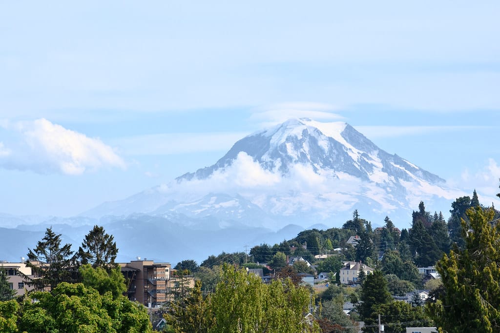
Tectonic movement can also be triggered by volcanic activity. Fortunately, much of nearby Mount Rainier’s daily volcanic activity is benign. Most do not realize that stereotypical lava and explosion is not the only dangerous volcanic activity. Events can include the venting of dangerous gasses, hot ash, or an especially difficult hazard called pyroclastic flow or lahar.
Lahars are flash floods of hot lava, ash, and debris. If an eruption lacks the pressure to send lava skyward, eruptions can push lahars down the volcano’s slopes of the volcano and through surrounding terrain at upwards of 100 miles an hour. They are nearly solid, capable of erasing any structure and even carving through existing terrain. Search and rescue attempts are complicated lahar quicksand-like texture, maintained for weeks after the initial event and made likelier in the Cascades by the glacial ice a lahar would melt and incorporate while descending.
Fortunately, Seattle itself is not at risk from these flows, but several towns in the Puyallup River Valley, such as Orting, Puyallup, Sumner and Fife sit atop solidified lahar flows that are only around 500 years old. Such flows travel along river valleys and could reach as far as Tacoma. Concerningly, lahars can also occur without any eruption at all. The deposits of volcanic ash and mud which active volcanoes produce over time can be loosened into sliding by heavy rainfall, earthquakes, or melting glaciers caused by unusually hot weather. The primary issues Seattle itself would face from volcanic activity are poor air quality and ashfall.

The Cake Topper
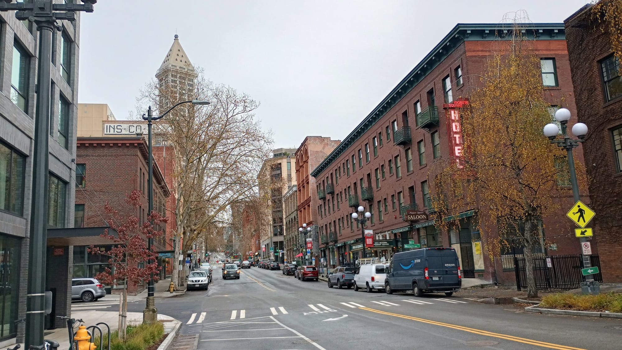
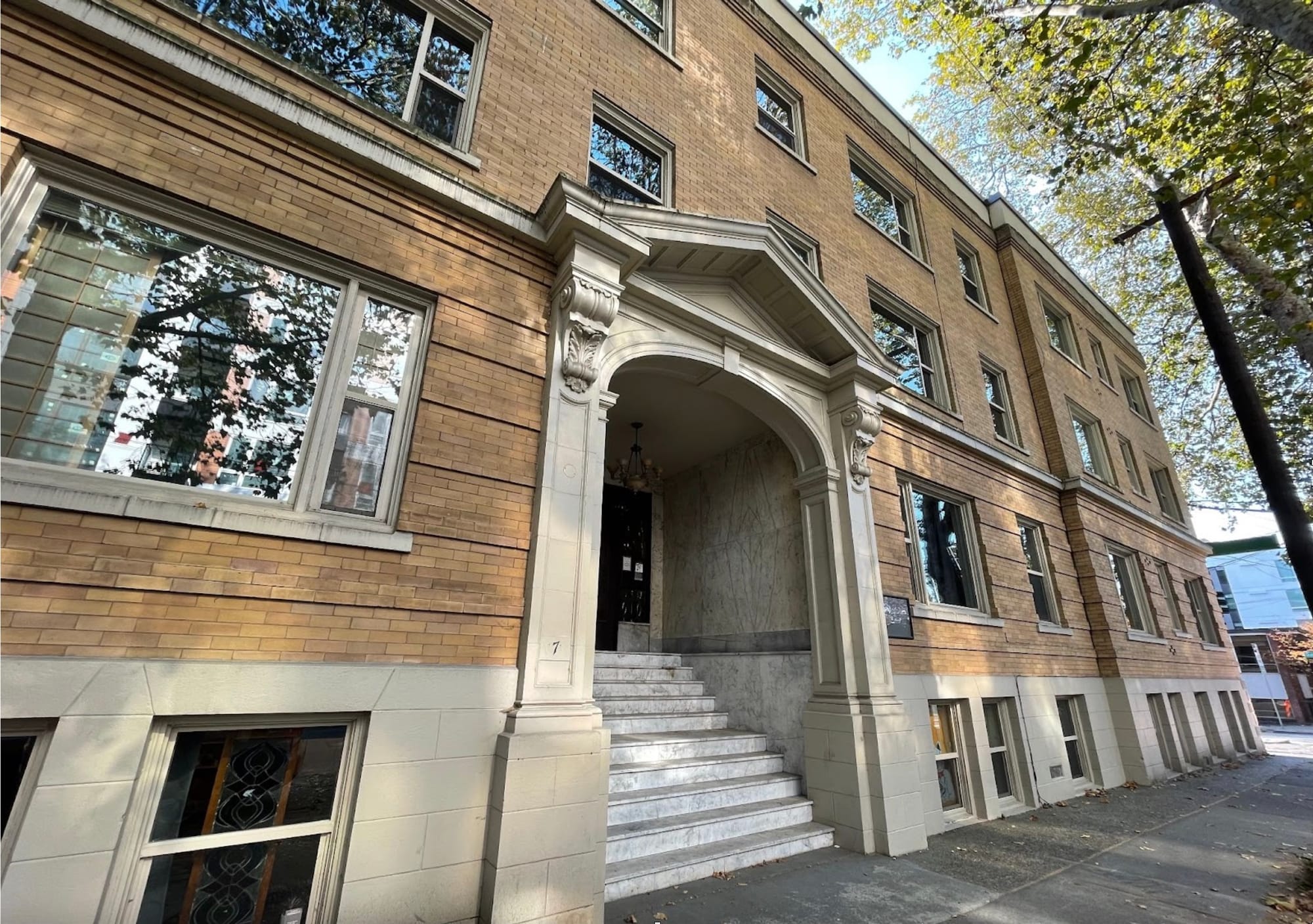
Now that we have a mushy cake, rigged with explosives and deadly icing, atop a cracked plate, let’s build something on it. Due to constant appearances of 1970s-era date stamps on geologic maps, papers, and research being presented as best-available science, I was reminded that we live in a town chock-full of buildings which predate seismic codes. Really, they predate widespread public understanding of geology as a field altogether. My neighborhood, Lower Queen Anne, is named for such houses; quaint, desirable, and dangerous. Passing by luxuriant, private-dock bearing homes built under the eroded lip of slopes above beaches drives me to make sidelong comments about listening to your geologist.
If, at this point, you find yourself in a similar anxiety-seeking mood, I suggest looking up your home and workplace on Seattle’s list of unreinforced masonry buildings (URM). These are historic brick buildings from before modern seismic improvements were required. A process has been underway since January 2013 to catalog these buildings and codify necessary retrofitting guidelines, but retrofitting is not currently scheduled to become mandatory.
This year, the Seattle Department of Construction and Inspections has hired a program manager to begin drafting the retrofit program, and Seattle City Council has proposed a resolution outlining the mayor and council’s “intent to consider strategies to ensure that all unreinforced masonry buildings in Seattle are seismically retrofitted.”
Previous attempts to create such a program have been hampered by concerns about cost, as well as the desire to avoid simply demolishing historic structures. However, a minority of these buildings are already retrofitted. Telltale signs include diagonal steel beams visible in windows, and bolts in exterior walls which are the ends of rods stabilizing interior floors. The city has released retrofit guidelines for owners of detached homes, but property owners are not currently legally obligated to retrofit. Residents can check whether they live or work in a URM using the Seattle Hazard Explorer.
Post-earthquake reality: “worst camping trip of your life”
My fascination about the region’s geology comes from a place of absolute curiosity. But, perhaps my discussion about preparing for digging out of The Big One is a bit morbid. Friends’ looks became wary as they examined my face for signs of paranoia until they had decided the science was sufficient. Some would eventually relax into the common atmosphere of gallows humor; others would simply beg me to stop. Perhaps the second response is more natural.
For many, the words “disaster preparedness” evoke images of stashes of water and canned food; this contains the implicit assumption that authorities and neighbors are of no use. The reality is that much of the burden of protecting citizens from the initial event falls on city governments to take action – often expensive, invisible and therefore unpopular action – before disaster strikes. Dealing with URM buildings is a perfect example. Though now moving, it has taken a decade and will not be immediately mandatory.
In October, former Seattle Office of Emergency Management Director Eric Holdeman published a short piece on his disaster-focused blog repeating the title message “No One is Coming to Help.” Grim, yes. And honest. Even the best-prepared city government cannot solve every citizen’s post-disaster situation right away.
Facing this lahar of good news, I wished to speak with a city employee to confirm whether my uninspiring impressions from conversations with friends reflected a widespread problem. I contacted Kate Hutton, Communications Coordinator and Strategic Advisor for Seattle’s Office of Emergency Management. She explained how, on a city-wide scale, unassuming things swell to outsize importance in the aftermath of disasters. Supply chain issues become compounded with the closure or damage of ports; visually unharmed buildings cannot be re-entered because of the risk of electrical fire or burst pipes. As we spoke, I was reminded of the reality checks many faced a few months into Covid: panicked people will dogpile onto less-than-stellar solutions, such as stockpiling extreme amounts of food and water and forgetting to ask who is going to watch their kids.
Worse, the stereotypical “prepping” scenario is a nuclear family with a garage of survival equipment. Since it is not accessible to most people in Seattle, many residents decide to do nothing. Hutton also described an “awareness gap,” which is the product of a city with lots of transplants and young people. Many are too young to remember the Nisqually quake of 2001, never practiced stop-drop-and-hold earthquake drills in school, or simply think “it won’t happen while I’m here.” This cultural knowledge can be replaced by what she called a “Hollywood-type awareness,” in which people picture themselves climbing out of lava’s reach, being rescued from highrises by helicopters, or defending against streets swarming with looters.
Hutton described a post-earthquake scenario which is much less adrenaline-fueled. Her words were “the worst camping trip of your life.” People should expect to stay within their immediate neighborhoods sharing food and assistance with neighbors and local businesses, because damaged infrastructure will make getting across or out of the city challenging or even impossible. Fortunately, in spite of media focus on looting, Hutton stated that people are overwhelmingly likely to group together and help after disasters.
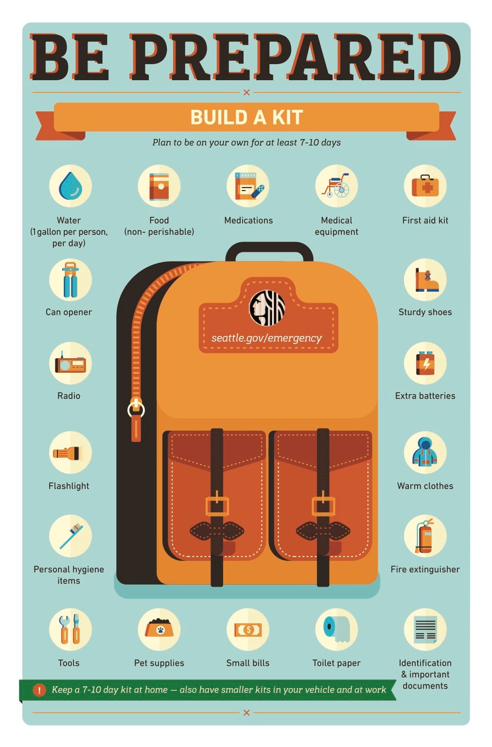
Hutton herself lives in a small apartment and said that it would take an entire “disaster room” to accomplish preparedness on an individual level. Rather, befriending your neighbors and talking to your friends means that you will find an immense pool of physical resources, as well as a team for handling post-disaster struggles. She also explained that if you ask for too much, people will do nothing. If you can store a few gallons of water and boxes of shelf-stable food, do it. But it’s more effective get to know neighbors, gather friends, and discuss who can do what. Is your neighbor a nurse who can help with injuries? Can anyone share camping equipment? What’s the plan for getting people back together if roads are clogged or damaged?
In that way, preparation for Seattle’s looming disasters is not all bad news. Sure, we live on a quivering mess of geology and the movies have us believe we’ll need to shoot our way out. But that is not the reality of emergency situations, and there are very effective ways for urban dwellers to get ready natural disasters. As Hutton emphasizes, in a city full of young singles in one-bedroom apartments, social connections are far more useful than typical “prepping.” Storing fuel, food and water is costly; having a conversation costs nothing.
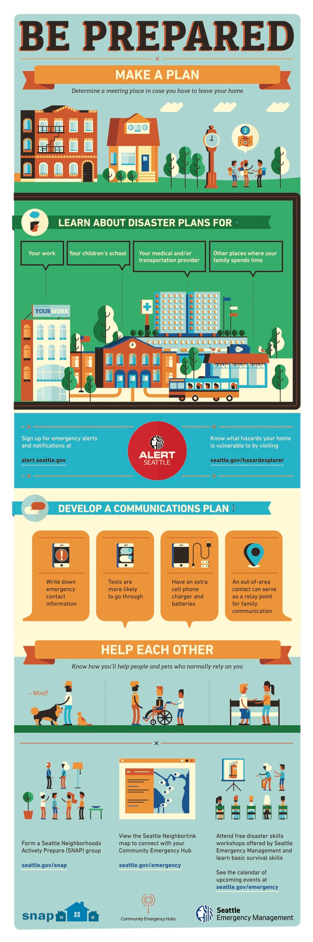
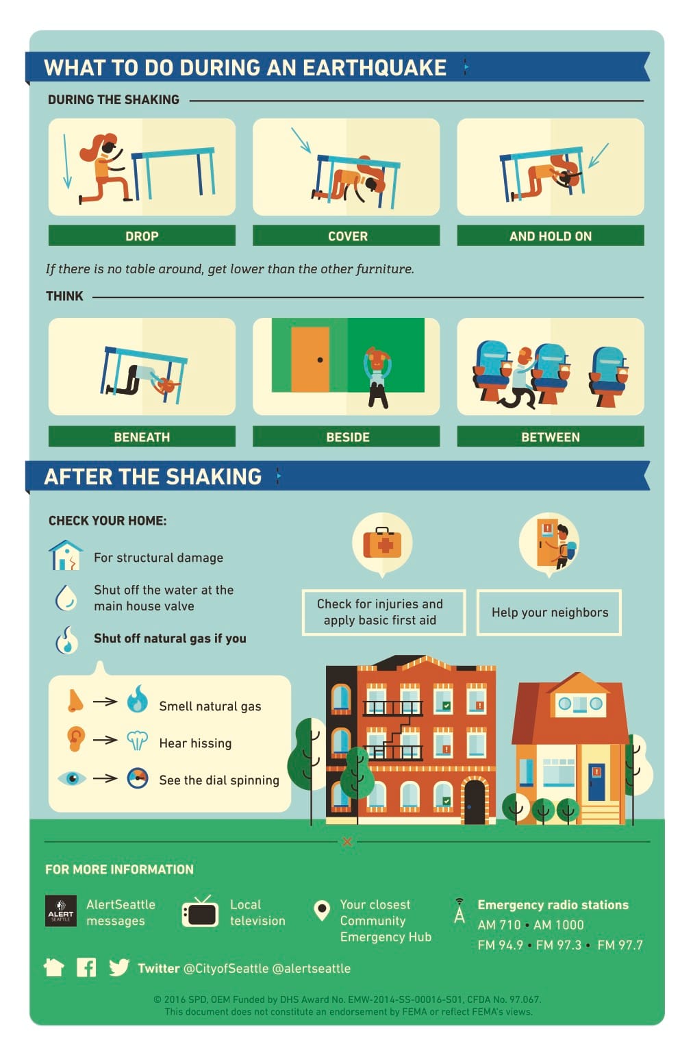
For practical information on how you can prepare, the City of Seattle has compiled a list of resources to help you and your loved ones get ready for earthquakes and their aftermath. This includes supply lists, a disaster plan template, and other helpful readiness information.
The City also offers hands-on classes for those who want to gain skills to respond to disasters.
Council Ponders Unreinforced Masonry Buildings and Rezones Madrona Site