The folks at the Seattle Depart of Transportation released an online public survey yesterday to gain public input on the Madison BRT project which will connect the Downtown Seattle Waterfront with First Hill and Madison Valley. (We previously covered this project back in November.) This survey primarily concerns the potential terminal locations, in Downtown Seattle and in the Madison Valley as well as the potential routes to get there.
Downtown Seattle Segment
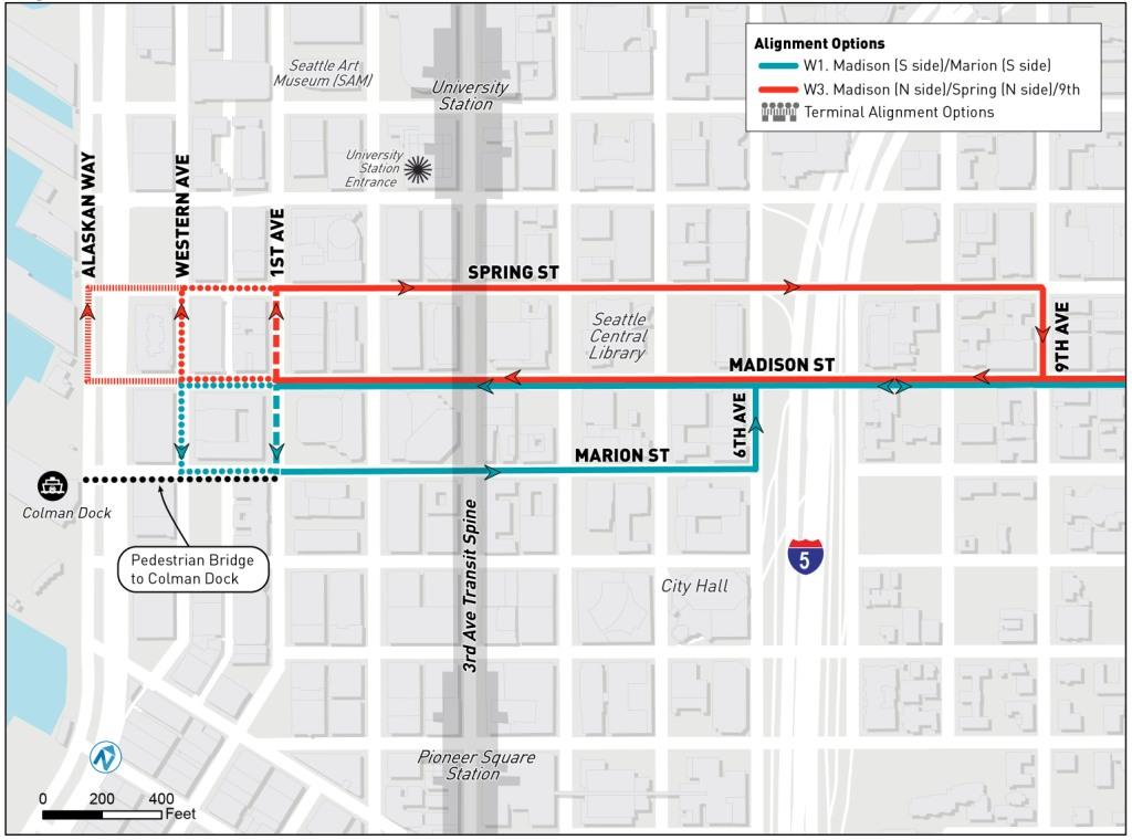
I would like to advocate for the Madison St/Spring St couplet (in red on the map) because it:
- Continues the connection to the Washington State Ferries Colman Dock;
- Provides a connection to the Center City Connector Streetcar (1st Ave/Madison St);
- Provides a better connection to the University Street Light Rail Station;
- Provides an excellent connection to the Central Library;
- Provides improvements to the King County Metro Route 2 on Spring St through the use of exclusive lanes, traffic signal priority, and enhanced station amenities;
- Provides a connection to Town Hall at 7th/8th Ave & Spring St;
- Removes the difficult turn at 6th Ave & Madison St; and
- Improves access to Virginia Mason Hospital while maintaining similar access to the Polyclinic.
Madison Valley Segment

For the eastern portion of the Madison BRT line, I would like to advocate for the MLK Jr. Way/29th Ave terminal (in red on the map) because it:
- Provides needed bus service to nearby residential communities;
- Supports planned construction in the area;
- Supports the businesses located in this area with improved access to Downtown/First Hill;
- Provides increased multi-modal connection opportunities;
- Provides enhanced station amenities for King County Metro Route 11 passengers where the lines overlap; and
- Removes a sharp turn and heavy traffic on 23rd Ave.
Madison BRT Alternate Bicycle Routes/Dangerous Intersections

In addition, the survey also seeks the public’s input on dangerous intersections throughout the corridor that are in desperate need of improvement for pedestrian and cyclist safety. In this case, I would advocate for Alternative 2 (in blue on the map):
- The route is a much more direct which is safer, less confusing, and more likely to be utilized; and
- As part of the First Hill Public Realm Action Plan, Union/University Streets on First Hill have already been identified as the location for an East-West cycle track.
As for the dangerous intersections, I will leave that up to those who are directly familiar with them and who have to make use of them each day (they all need fixing).
Potential Stop Locations
Here I would advocate for the following stop locations:
| Eastbound
|
Westbound
|
To participate in the survey, click the grey “Start the Survey” button or simply click here.
Full disclosure: I am a resident of First Hill and I am on the Board of the First Hill Improvement Association (FHIA) and sit on the Transportation Working Group. These are my personal opinions and while in sync with FHIA, they should not be construed as the official position of FHIA. Illustrations are courtesy of SDOT and used with permission.