Just over a week ago, Sound Transit’s Chief Executive Officer, Peter Rogoff, announced that his agency would reverse course on branding of the light rail line running between the University of Washington and Angle Lake. The transit agency had recently begun implementation of its new systemwide branding effort, which sought to call the initial operating corridor the Red Line until becoming the Green Line in 2035 when the Ballard extension is slated to open. In listening to community members, staff heard clearly that many were concerned about the name, given the historic effects of “redlining” practices that were applied to communities of color in communities now served by the light rail line.
Context of redlining
Before getting into how Sound Transit ended up with line’s name and highlighting system rebranding and usability options, it is important discuss the context of redlining. A primary facet of redlining was a financial risk assessment practice where banks and insurance institutions would not lend or insure real estate in areas that were considered to be poor and risky investments.
“These discriminatory practices caused widespread damage and inequities that have had a lingering impact to this day,” said Jackie Martinez-Vasquez, Sound Transit’s Chief Equity and Inclusion Officer in an agency blogpost. “In response, we are going to identify a new system for identifying our routes. It’s the right thing to do, and we are grateful for the community members who encouraged us to take this action.”
Redlined areas closely tracked with where people of color lived. In Seattle, that meant the Central Area, Chinatown-International District, Beacon Hill, and parts of the Rainier Valley were designated as “hazardous” and functionally identified as red on security risk maps, hence redlined. Yellow-lined areas often had the same practical effects and were even more widespread.
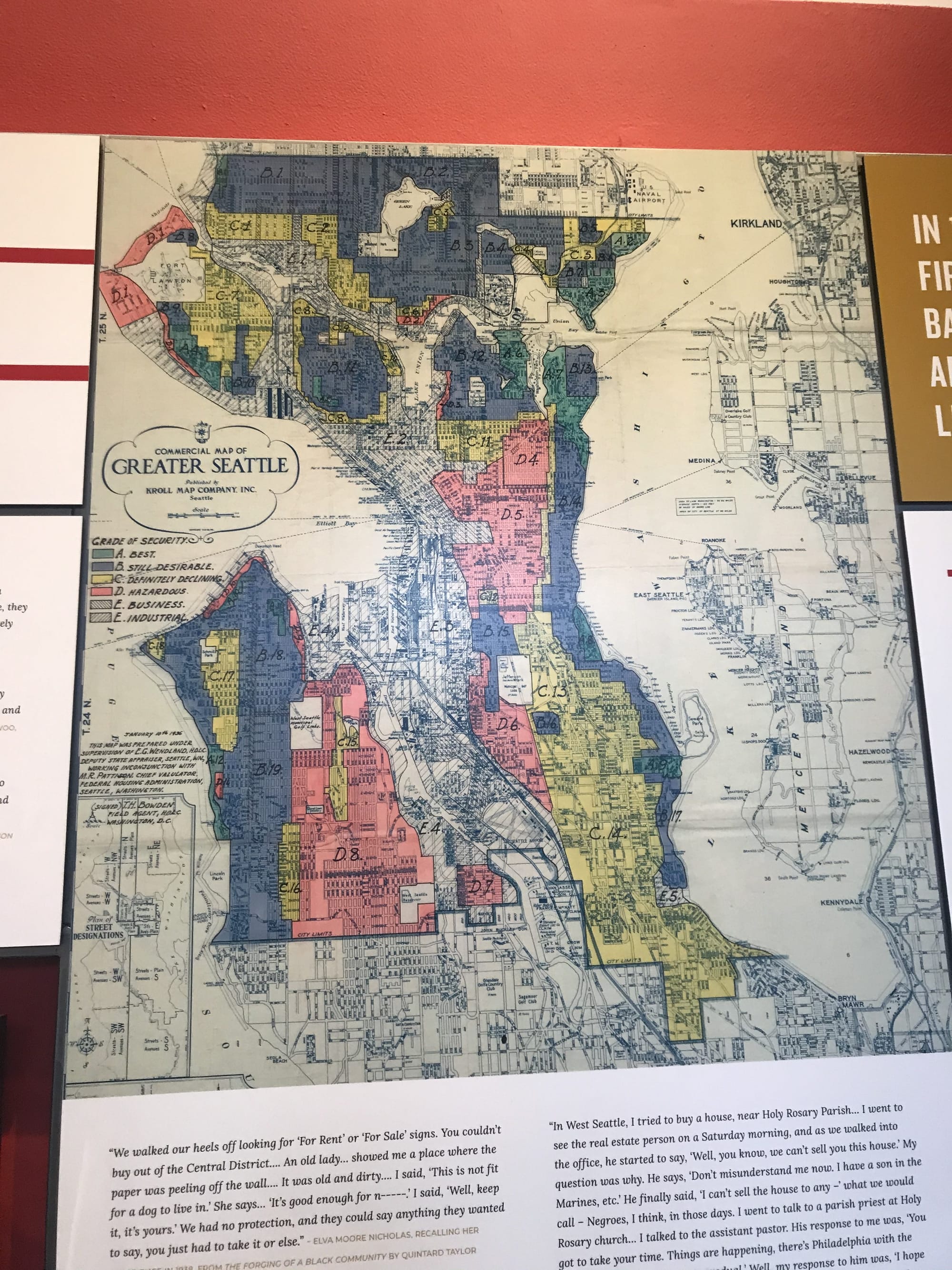
In the mid-1930s, the federal government began a process of establishing these risk classifications through the Federal Home Loan Bank Board and Home Owners’ Loan Corporation, which financial institutions relied upon for investment decisions. Regardless of the actual condition of neighborhoods, racial makeup was a driver in determining risk. Predominantly Caucasian neighborhoods fared better in the risk ratings and many had restrictive covenants in place that precluded non-Caucasian individuals from owning property. Other prejudicial history played a socioeconomic role in how people came to live in places of American cities, such as the “alien” land laws, Jim Crow laws, racial steering, and racial zoning laws.
Fundamentally though, the process of redlining was systematic and used to protect the interests of privileged people while restricting opportunity, extracting and holding down wealth, and concentrating people that were considered lesser than the privileged ruling class. This was then further exploited through later processes, such as blockbusting and White flight, which drained capital from central cities and further harmed communities of color, essentially locking them in. So it is understandable then why people might object to a light rail line being called a “Red Line” in areas still marked by this painful history and stigma.
How we got here
The process of how Sound Transit ended up with the Red Line goes back to 2012. That year, the Sound Transit Board of Directors approved a policy framework for the light rail system naming process.
The policy framework indicated that Sound Transit would implement “a comprehensive naming structure for the entire Link light rail system that uses a color scheme and naming conventions for planned and future Link light rail lines.” It also outlined criteria that “[e]ach line will have an ‘end-of-the-line’ destination name and an associated color, which is [Americans with Disabilities Act (ADA)] compliant.” The suggested initial colors were red (for the north-south line) and blue (for the east-west line).
Geoff Patrick, Deputy Executive Director of Communications for Sound Transit, explained additional factors that led to choosing the current color approach and name. “[S]taff relied heavily on peer practice, as well as [Federal Transit Administration] and ADA guidance to use primary colors for initial lines, choosing colors for adjacent lines that provided greatest contrast,” he wrote. “This approach is also reflected in other systems. Of 24 mass transit systems nationally, 21 have a red line. Of those 21 systems with red lines, 10 use the name Red Line.” Examples are abound, such as Washington, D.C.’s Metrorail and Boston T. The New York City Subway also has several red lines, but these are general referred to by individual service number (i.e., 1, 2, or 3) for each branch line.
According to Patrick, Sound Transit also sought professional assistance from design specialists and public feedback in developing system branding. “The agency engaged a signage consultant to verify and confirm signage standards and best practices as they related to staff’s recommendation for a red and blue line for initial services,” he wrote. “Prototypes of maps developed by the consultant were tested in a survey given to riders. Approximately 220 surveys were received in which riders confirmed that the colors were clear and easy to understand.” Comments from that process did not indicate concern for using the preferred color approach.

However, Patrick noted that “[the] survey did not specifically test reactions to the names Red Line and Blue Line.” Doing so may have helped avoid the predicament that the transit agency now is in. But it is also possible that the breaking work and growing community consciousness surrounding redlining may not have yet been as significant in 2012 when the process began.
Fundamentally, the choice of colors became solidified in a staged process and to provide strong contrast that would avoid problems for people who have color-distinguishment challenges. The Red Line and Orange Line were be the first colors put into use and with no overlap in the system or through maps.
Sound Transit decided that the process of color implementation would be staged:
- The Red Line would be the primary north-south line and sequentially extended as extensions opened to Northgate, Federal Way, and Lynwood. This would remain functionally unchanged until at least 2030.
- In Tacoma, the Link streetcar would be the Orange Line for the foreseeable future.
- In 2023, the Blue Line would be introduced, operating from Northgate through Downtown Seattle and then to Eastside, and then being extended to Lynnwood and Downtown Redmond when those extensions opened in 2024.
During this timeframe when the Red Line and Blue Line overlapped, their bold contrast would be unmistakable. However, once 2030 rolled around, things could have wound up changing with the slated opening of the West Seattle extension. Could this have forced the introduction of the Green Line or the Red Line? Or for the temporary West Seattle stub line? Or could have it resulted in a different combination? That remains unclear.
By circa 2035 though, the map and naming convention certainly would have fully shifted with a portion of the Red Line, including the portion through the Rainier Valley and south of Chinatown-International District becoming the Green Line while the remainder from there and north staying the Red Line (see map above). This swap still would have maintained the kind of contrast necessary to keep color lines clear.
What could be instead
Sound Transit is now committed to developing a new naming convention for light rail service. A first step to this, however, is to end use of the Red Line term through communications and announcements. The transit agency says that they intend to just use the term “Link light rail”–which is already common and its official name. Riders on the other hand, may be less familiar with this name despite its branding for the system, including signage and use in announcements. More jargony is “Central Link”, which is what the former program name was for the line running through Seattle.
Sound Transit hopes to have a new naming convention adopted by March, which leaves a very short four months to draw up and test out ideas and then get consensus on a single approach. The timing is somewhat constrained because the transit agency needs lead to time redesign signs and maps to facilitate the change for implementation in 2021 as part of the Northgate Link extension. That extension opening is widely expected to occur in early 2021 since construction remains well on-schedule and within the six-month construction schedule float.
It is possible that another color will simply be chosen, but some on social media suggested that alternative color variants for red like ruby or cherry could simply supplant it, either in name only or as a literal mapped color change. That seems to go against the concept of primary colors and use of the most common terms, for which Sound Transit has a stated preference. Choosing more obscure terms for colors could confuse people who do not speak English as a first language. It also could fail to provide the kind of contrast that Sound Transit prefers for system identification on maps, icons, and signage.
Alternatively, Sound Transit could wind up using entirely different approaches, depending on where the short-term rebranding journey takes staff in the next several months. Could lines, or a combination thereof be referred to by names, letters, numbers? When asked about this, Patrick was not definitive. “We’ll take some time to consider our options and methodology for updating our naming system and at this moment will hold off on speculating,” he wrote. So perhaps it is indeed open-ended.
Setting aside very real challenges and drawbacks to rebranding options for a moment, there are several approaches beyond a named system by color that Sound Transit could choose from.
If Sound Transit elects a letter-based or number-based naming convention, service could be easily understood by riders. Sound Transit could choose any set of colors and could be less choosy about contrast, though primary colors would still be preferable. A number-based naming convention would probably be a much smaller hurdle than letters if only because King County Metro and other transit agencies would likely be amenable to eliminating the use of single-digit bus route numbers from their networks. Sound Transit could choose to call their light rail service a “line” or “train” which is highly distinguished from local transit parlance of “route” for individual bus services. But Metro could retire several of its line names in the A through D range–although it might not be excited about rebranding it’s most popular lines.
Another option is to name lines with memorable names, like the London Underground’s Piccadilly Line, Hong Kong’s Tsuen Wan Line, or Vancouver’s Millennium Line. Sound Transit could use a single theme or mix of themes, such as geographic references (e.g., Mount Tahoma or Rainier Valley), honorary references (e.g., Chief Sealth or Landes), or historic references (e.g., Independence or Interurban). The main drawback is that these references may be less understandable to tourists and people who do not speak English as a first language or have low literacy skills.
System branding hurdles
There are some obstacles to renaming the light rail system though. King County Metro already uses letter-based identification for the RapidRide bus network. They hope to use the full alphabet in the time period that Sound Transit plans to build out its Sound Transit 2 and Sound Transit 3 light rail expansions. Having a Sound Transit “A Line” or “A Train”–as that is almost assuredly what the Red Line would be called in such a system–meet an A Line RapidRide route in SeaTac seems like a recipe for travel disaster. For local riders, “A Line” is used in common parlance and having two overlapping ones would introduce unnecessary confusion and lack of confidence. This is especially problematic for infrequent riders or visitors.
Technically, Metro’s own existing RapidRide branding with color is confusing, especially when overlapping with Sound Transit’s Red Line on static and digital maps. Relatedly, Community Transit’s Swift bus network uses a color naming and branding convention that is in conflict with Link, or at least could be in the future. Community Transit has both a Blue Line and Green Line in operation as part of Swift, but neither currently intersect with Link. That will change as light rail approaches Lynnwood, and in 2024, Community Transit plans to extend its Swift Blue Line to the Link station opening that year at NE 185th St in Shoreline. This would result in the convergence of two Blue Lines, which undoubtedly will present some level of unnecessary confusion.
This competition among local transit providers for service branding is problematic, but Sound Transit probably will not be able to resolve that initially through its own rebranding effort.
Additional system usability options
Going a step further, Sound Transit could enhance system usability. For instance, each station could be assigned unique letter-number pairs. This is commonly used in Asian systems (e.g., Bangkok and Tokyo) for easy navigation. Usually, a train line is assigned a letter and numbering occurs sequentially from a terminus.
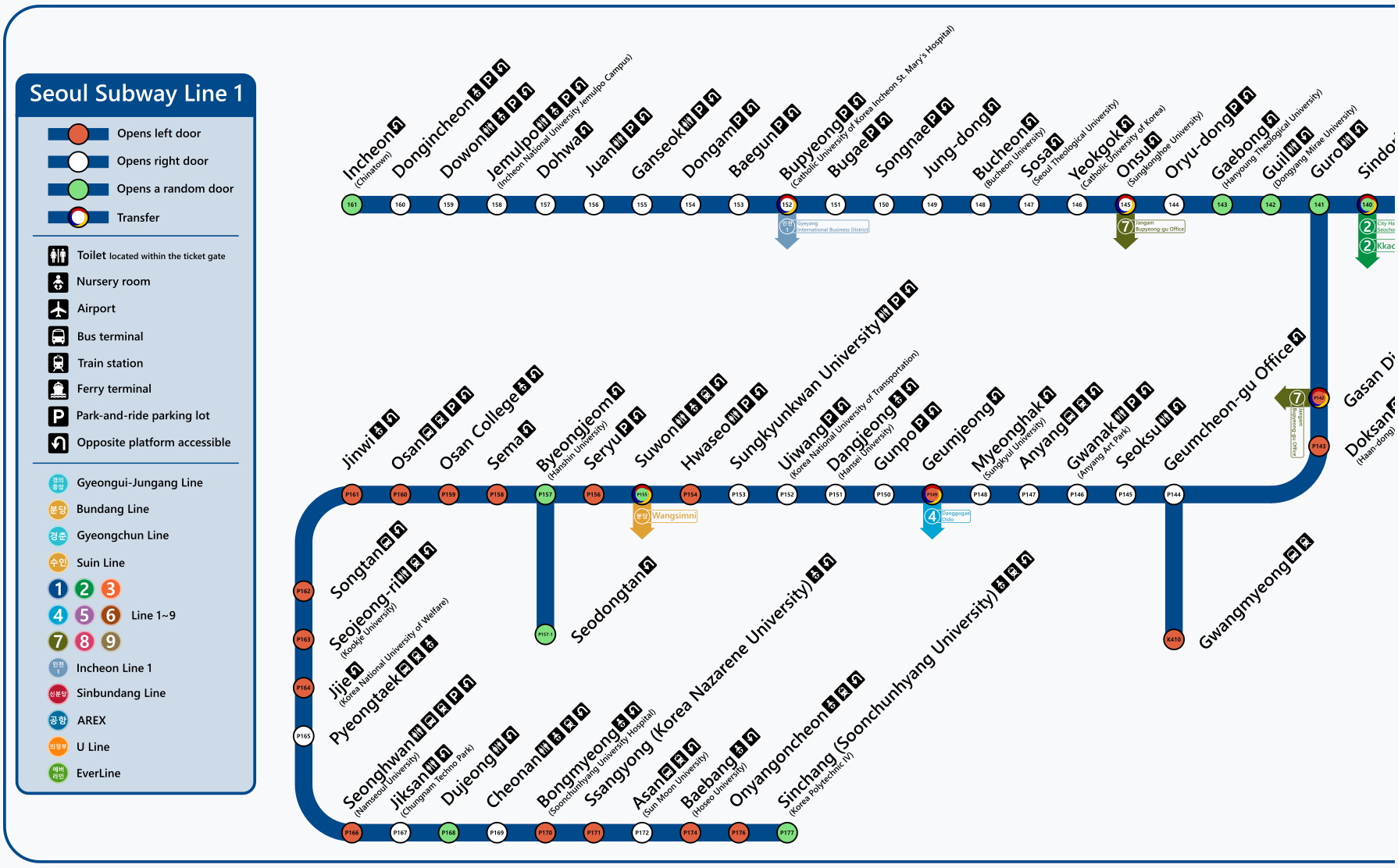
Applying this approach to the Central Link line, Sound Transit could start a letter-numbering plan from Northgate (though it would need to be modified once the Lynnwood extension opens). This could wind up starting as “A1” and go sequentially up for stations to the south, which would result in Westlake Station being “A6”. For riders, this allows for an easy mental calculation where they can place themselves within the system and know where they want to go. Getting to Westlake Station is just a five-stop ride. In some cases, stations would have multiple station codes. The usefulness of this is mostly in printed maps and system diagrams with stations. A variation on this is Seoul, which primarily uses a three-digit station numbering system that corresponds to line numbers.
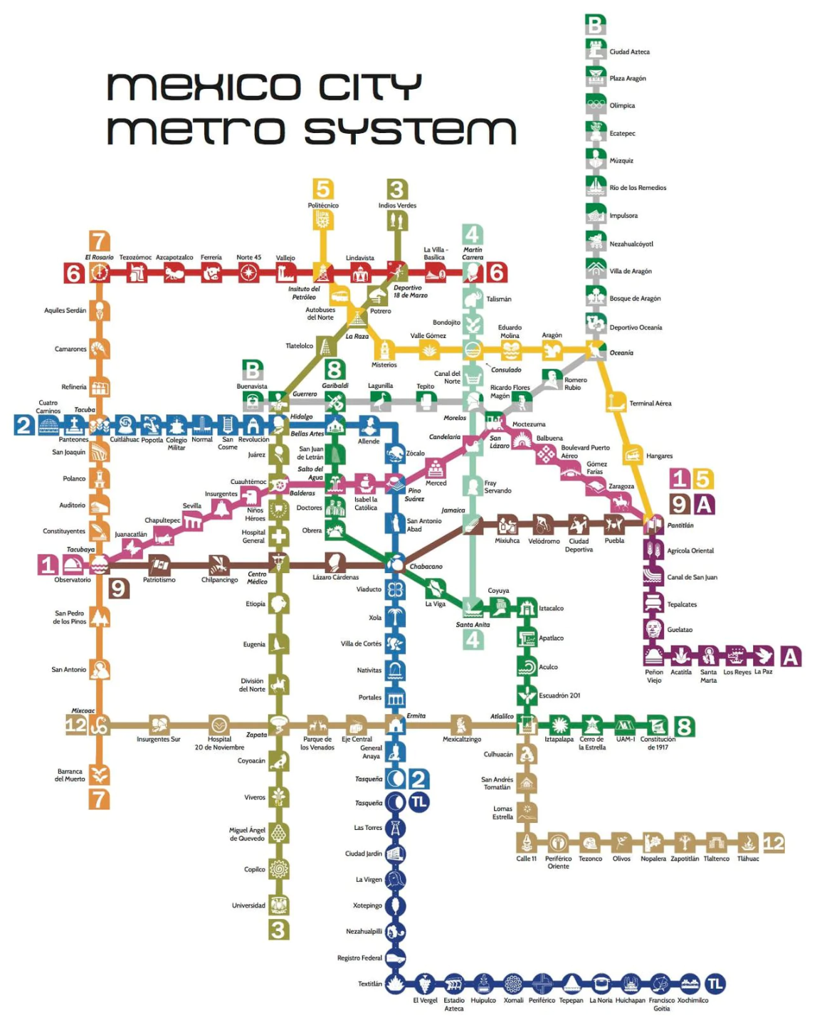
Another option could be a revamp of the pictograms, which were launched as part of the University Link extension in 2016. The chosen set of pictograms in use are largely unmemorable and difficult to describe. The best example of pictograms in use for transit is found in Mexico City, which much more clearly related images to station name or context. Pictograms also appear as a shield in with the line-assigned color. Where more than one line meets at a station, the shield mixes the line colors diagonally. While this is not terribly useful in calculating stops between stations or being describable to other riders, they are useful in quick identification of a station or visually remembering if the written or spoken station name is not easily intelligible to a rider.
Uncharted future
The bottom line is that while the Red Line decision was abrupt, it was the right call for Sound Transit to make. All transit systems should be welcoming spaces to riders. Invariably, mistakes can be made but making things right goes a long way to building goodwill. This case also presents a unique opportunity for the transit agency to actively engage community that it might not have had for years to come in reconsidering how the system could be functionally more understandable and accessible to riders, but only if Sound Transit fully seizes the moment to do so. Will the naming conventions change? And can system usability take a leap in tandem with this process? We will know in a few short months.